Ohio County is a compact southeast Indiana county where Rising Sun sits directly on the Ohio River and steep creek-cut hills fill most of the interior. You can download the high-resolution JPG ZIP directly from this page. The larger files are useful for reading road shields, branch and creek names, and elevation shading. This Ohio County Indiana Map page combines the Rising Sun road pattern with a one-place city index, Ohio River and interior tributaries, and a 139–281 meter relief surface that rises sharply away from the river.
Rising Sun is the simplest place to use for orientation. Indiana State Library materials identify it as the Ohio County seat, and the general map places the developed area against the eastern river boundary. U.S. 56 follows the river side, State Road 156 continues south along the same edge, and Route 262 turns inland across the hill country. That combination makes it easy to separate the narrow river corridor from the more rugged western interior.
The terrain changes quickly once the map leaves the Ohio River. Mud Lick Creek, Willow Creek, Arnold Creek, Bear Creek, and smaller branches cut narrow valleys through densely packed ridges. The elevation legend reports an actual range of about 139 to 281 meters and a mean of 222 meters. The river edge and larger creek bottoms remain green and low, while much of the center and west climbs into tan and brown uplands over a short distance.
Table of Contents
Rising Sun anchors the river road while Route 262 reaches into the interior hills
Rising Sun has the clearest developed footprint on the general map and sits immediately beside the Ohio River. U.S. 56 provides the strongest north–south road reference along the river, while State Road 156 continues through the lower river side. The Ohio County Courthouse label appears near Rising Sun, reinforcing the city’s administrative role as well as its geographic importance.
West of Rising Sun, the road network becomes noticeably more winding. Route 262 is the most obvious inland number, but many local roads curve along creek valleys and around ridge slopes rather than following a broad regular grid. The northern boundary is deeply indented and the southwestern side also bends repeatedly, so county shape and road curves are often useful orientation clues.
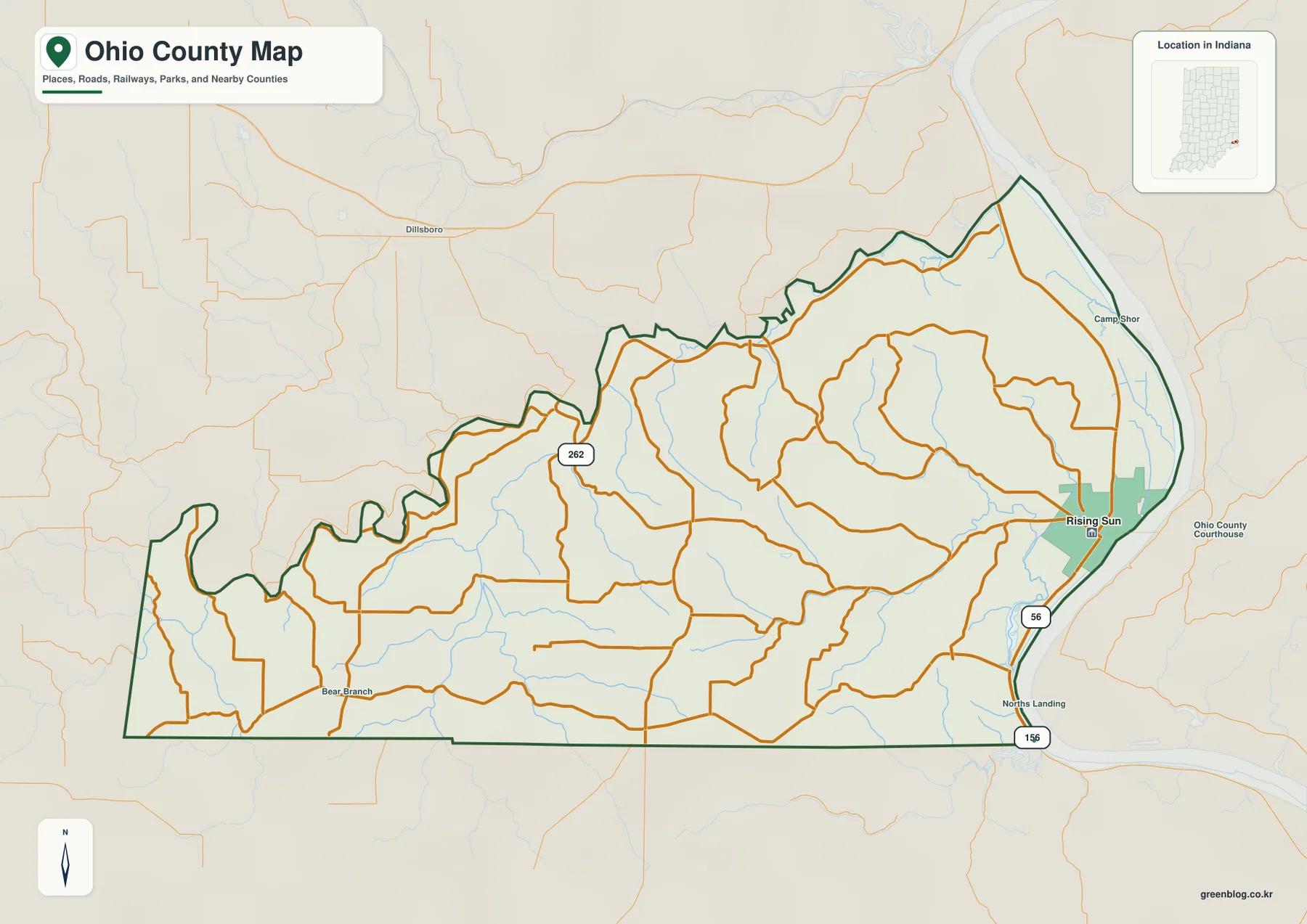
Camp Shore appears near the northeastern river side and Norths Landing provides another small reference farther south. Bear Branch sits toward the southwest. None of these places has the visual weight of Rising Sun, but they help divide the county into northeast, southeast, and southwest sections where large town labels are absent.
Dillsboro appears beyond the western county boundary and can be used only as outside context. The map’s main subject remains the road pattern inside Ohio County: a riverfront city and highway on the east, followed by increasingly crooked local roads through the interior. That contrast becomes even clearer on the water and elevation views.
The city index highlights Rising Sun as the single major city entry
The supplied city index contains one major-city entry: Rising Sun, printed at 2,474. That number belongs to the supplied map edition rather than a live demographic feed. Because there are no other ranked places on this view, the map is most useful for confirming Rising Sun’s location on the eastern Ohio River edge rather than comparing several cities.
| Rank | Place | Value printed on map | Position |
|---|---|---|---|
| 1 | Rising Sun | 2,474 | Eastern Ohio River edge |
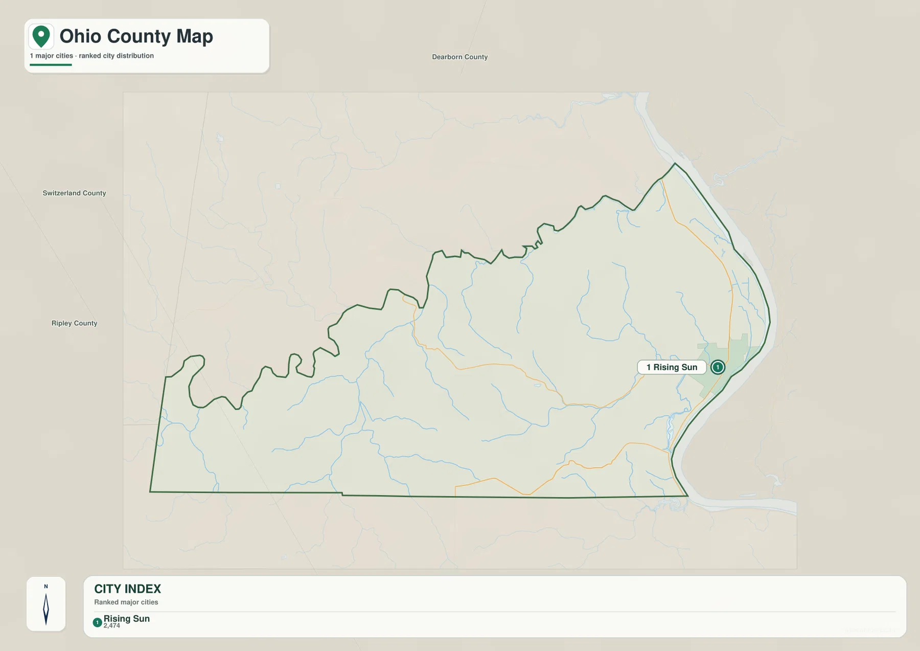
The index deliberately leaves out smaller labels such as Camp Shore, Norths Landing, and Bear Branch. Return to the general map when those places or their connecting roads matter. In a county with only one highlighted city, the simplified view serves more as a locator than as a ranking graphic.
Indiana State Library and state county information identify Rising Sun as the county seat. Treat the printed value as part of this specific map edition, not as a current population total. For present-day demographic work, use the latest Census or other official statistics instead of carrying the index number forward as live data.
Ohio River lowlands meet a dense network of interior creek valleys
The Ohio River dominates the eastern edge of the terrain-and-water map. Its broad channel creates the largest lowland in the county, while the interior rises sharply almost as soon as the map moves west. Starting with the river makes the smaller tributary valleys much easier to understand because nearly all of them descend from the hill country toward the eastern drainage system.
Mud Lick Creek and Willow Creek cut long valleys through the west-central interior. South Fork, Dry Branch, and Murray Branch add smaller lines around the same area. Bear Creek and Bear Branch provide southwestern references, while Logson Branch appears farther northwest. The waterways are narrow compared with the Ohio River, but they are critical to the shape of the terrain because each one separates neighboring ridges.
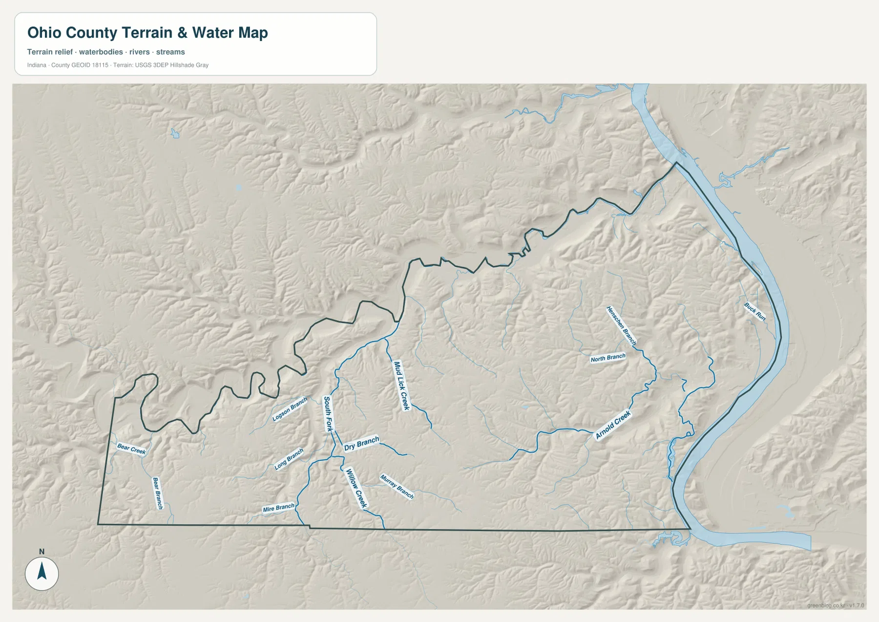
Arnold Creek is a strong central-eastern tributary, and several smaller branches cut through the northeast. Duck Run is labeled near the river side north of Rising Sun. These water lines explain much of the irregular road pattern: local routes repeatedly follow valley floors, cross tributaries, or bend around steep slopes instead of maintaining a simple rectangular layout.
This water image is a geographic and terrain reference rather than a flood or navigation product. It does not establish current river stage, water quality, legal stream limits, property ownership, or safe navigation conditions. Those decisions require current information from the appropriate USGS, FEMA, state, or local agency.
The 139–281 m relief climbs quickly from the Ohio River into steep interior ridges
The elevation legend gives an actual Ohio County range of about 139 to 281 meters and a mean of 222 meters. The lowest terrain follows the Ohio River and larger creek bottoms in green. Just inland, the surface changes rapidly through yellow and tan into broad brown ridge tops, producing one of the sharpest river-to-upland contrasts in this county map series.
The center and west are not one continuous plateau. Mud Lick Creek and Willow Creek cut green corridors into the high interior, and smaller branches create additional notches between neighboring ridges. The result is a tightly dissected landscape of short ridge crests and deep narrow valleys rather than a smooth high plain.
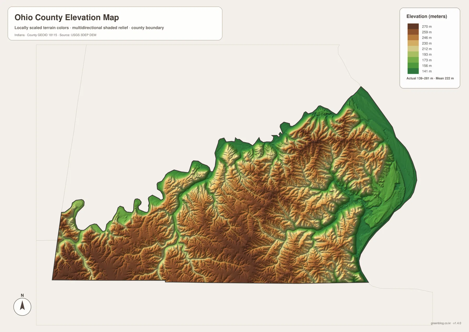
The northeastern river margin also stays low, but the ground rises sharply inside the county boundary. Arnold Creek and other branches remain green through higher slopes, while the ridges between them turn tan and brown. The same contrast continues south of Rising Sun, where the riverfront roads occupy a narrow low corridor beside much higher inland terrain.
The 139–281 meter range is intended for county-scale comparison. It is not precise enough for a parcel corner, building pad, roadway grade, or drainage design. Those uses require original elevation data such as the USGS 3D Elevation Program or measurements from a qualified survey.
Keep Rising Sun fixed while comparing river roads, tributary valleys, and interior ridge height
For roads and place labels, start with Rising Sun on U.S. 56. Add State Road 156 along the lower river side and Route 262 into the interior. Camp Shore, Norths Landing, and Bear Branch provide smaller anchors when the map moves away from the city. This sequence is more useful than trying to locate every local road at once.
The city index has only one major entry, so use it simply to confirm Rising Sun’s riverfront position. The general map is the better choice for smaller place labels and road detail. If a current population total is needed, use an official statistical source rather than the map’s printed 2,474 value.
For physical geography, locate the Ohio River first and then trace Mud Lick Creek, Willow Creek, and Arnold Creek inland. Switch to the elevation image at those same locations and the pattern becomes obvious: the water corridors stay low and green while ridge tops rise quickly around them. This side-by-side view explains both the county’s rugged appearance and the winding road network.
The WebP images on this page are reduced previews. The Ohio County archive contains four original 3638×2572-pixel JPG files covering the general county map, city index, terrain-and-water map, and elevation map. The larger originals are better for printing or reading small road, branch, creek, and place labels.
A useful comparison is to keep Rising Sun fixed as the riverfront reference. Find Routes 56, 156, and 262 on the general map, confirm Rising Sun on the city index, trace Ohio River and Mud Lick Creek on the water map, and finish on the elevation image by comparing those low corridors with the surrounding brown ridges.
Frequently Asked Questions
What is the county seat of Ohio County?
Indiana State Library and state county information identify Rising Sun as the Ohio County seat. On the supplied map, Rising Sun sits directly beside the Ohio River near U.S. 56 and State Road 156, making it the easiest city reference in the county.
Which waterways are easiest to recognize?
The Ohio River forms the dominant eastern water boundary. Mud Lick Creek, Willow Creek, Arnold Creek, Bear Creek, Duck Run, and several smaller branches cut low corridors through the interior hills. The water image is for geographic orientation rather than flood, property, or legal-boundary decisions.
Can the 139–281 m elevation range be used for exact site measurements?
No. The image gives a county-wide range with a mean of 222 meters and is intended for comparing the Ohio River lowland and creek valleys with the higher interior ridges. For an Ohio County parcel, building site, roadway grade, or drainage plan, use original elevation data or a qualified survey rather than this county-scale relief image.
Map File Information
The Ohio County ZIP combines the general road-and-place map, one-place city index, terrain-and-water map, and elevation map as full-resolution JPG originals.
- File Type: ZIP containing four 3638×2572px JPG files
Related Maps
Sources and References
The article is based primarily on the supplied Ohio County map set and asset manifest. The following official sources provide Rising Sun, county, boundary, hydrography, and elevation context.
- Indiana State Library – Ohio County – official state reference identifying Rising Sun as the county seat and providing county-history resources
- Indiana Counties – state county reference for Ohio County, Rising Sun, and local administrative information
- U.S. Census Bureau TIGER/Line Shapefiles – boundary reference for Ohio County and nearby places
- USGS National Hydrography – reference data for Ohio River, creeks, and branches
- USGS 3D Elevation Program – source terrain data for detailed elevation work
Green Map creates custom-edited map images using open geographic data sources such as geoBoundaries, Natural Earth, OpenStreetMap, and government open data.
These maps are edited visual materials, not raw data files, and are provided for education, documents, presentations, and graphic reference.