Marion County is dominated by the Indianapolis urban area, but the map also separates Lawrence, Speedway, Beech Grove, Southport, Meridian Hills, and several smaller towns within and around that broad city footprint. You can download the high-resolution JPG ZIP directly from this page when you need larger road, rail, water, or terrain labels. This Marion County Indiana Map page connects the Indianapolis settlement pattern with White River, Fall Creek, the Eagle Creek system, and an elevation surface that places a long central lowland between higher western and eastern ground.
The county is easiest to understand by starting in Indianapolis and then locating the smaller incorporated places around it. Lawrence occupies a large northeastern area, Speedway sits west of the center, Beech Grove is southeast, and Southport lies near the southern edge. Meridian Hills, Williams Creek, Crows Nest, and Rocky Ripple form much smaller northern references, while Warren Park and Cumberland mark the east. The result is a county map with unusually dense settlement labels compared with the more rural Indiana counties nearby.
Water and relief create a second organizing framework. White River runs down through the center of the county and provides the clearest low corridor, while Fall Creek approaches from the northeast. Little Eagle Creek and Big Eagle Creek divide the west, Pleasant Run and Buck Creek cross the east, and Little Buck Creek lies in the south. The supplied elevation legend reports an actual range of about 86 to 279 meters and a mean of 239 meters, with the White River corridor notably lower than the higher terrain along both sides of the county.
Table of Contents
Indianapolis fills the center while smaller cities and towns form distinct local pockets
The general map labels “Indianapolis city (balance)” across the broad central area, and major roads and rail lines radiate in several directions from that urban core. Ascension Saint Vincent Hospital appears in the north and Community Heart and Vascular farther northeast, providing recognizable map references inside the larger city fabric. The map does not need every road number to make its main point clear: Indianapolis occupies most of the county, while several separate municipalities interrupt or border that footprint.
North of the center, Williams Creek and Meridian Hills appear close together, followed by Crows Nest and Rocky Ripple nearer the White River side. Their footprints are small, so they are easier to miss than Lawrence or Speedway, but they are useful when comparing the detailed general map with the city index. Rocky Ripple is particularly easy to relocate on the water view because of its proximity to the White River corridor.
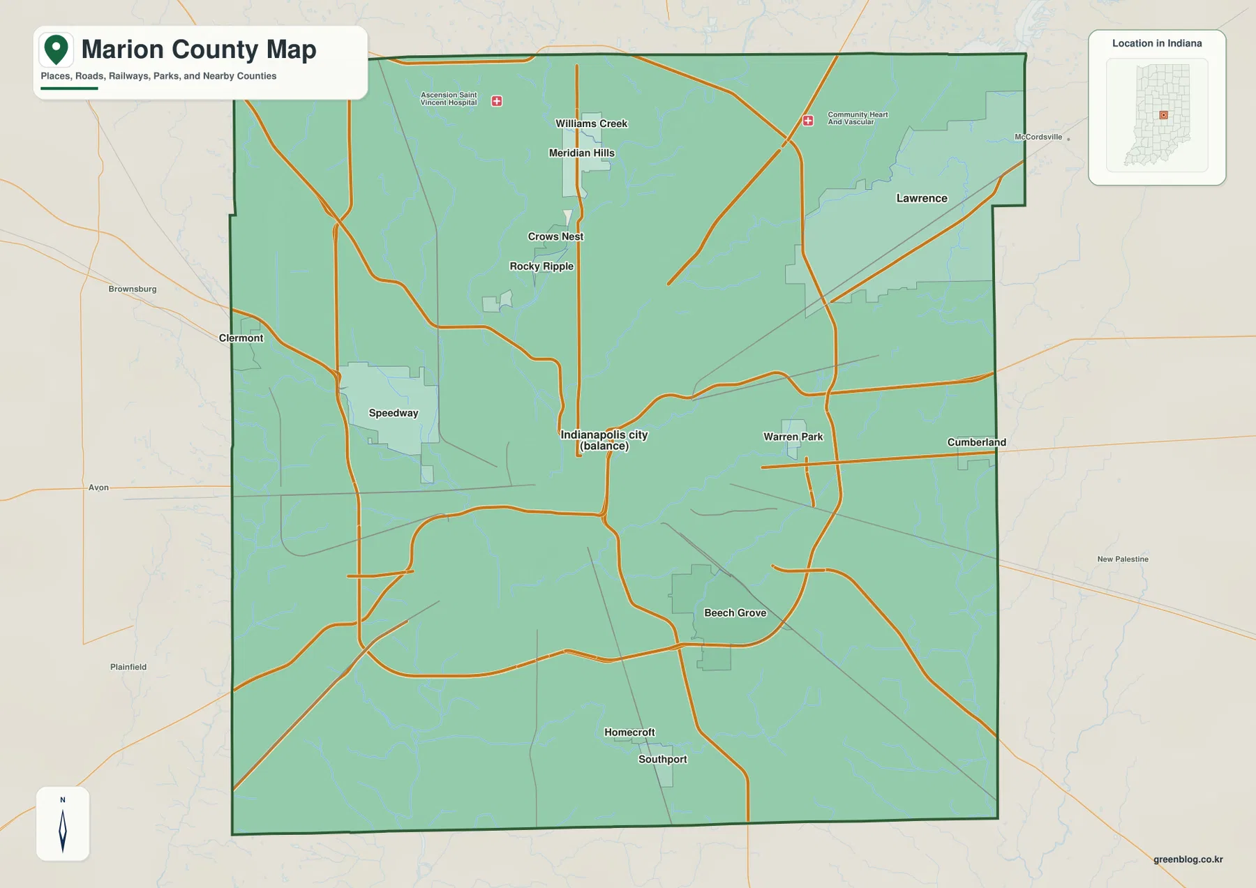
Speedway is the strongest separate western city reference, with Clermont farther toward the county line. Beech Grove creates another distinct municipal area southeast of central Indianapolis. Warren Park and Cumberland are smaller eastern references, while Homecroft and Southport sit close together in the south. Looking at these places together makes it easier to see that Marion County is not represented by one uninterrupted Indianapolis polygon.
Lawrence is different from the smaller enclaves because it covers a broad northeastern area. It reaches close to the county’s upper and eastern edges and is visually much larger than Meridian Hills, Southport, or Warren Park. That makes Lawrence, Speedway, and Beech Grove especially useful as three directional anchors when moving between the road map, city index, and water map.
The city index makes the scale gap between Indianapolis and the surrounding municipalities easy to see
The supplied city index highlights six places. Indianapolis City (balance) is printed at 885,860, Lawrence at 49,517, Beech Grove at 14,913, Speedway at 13,968, Southport at 1,975, and Meridian Hills at 1,767. These figures belong to the supplied map edition rather than a live population feed. Their main use on this page is to show the enormous difference in scale between Indianapolis and the other highlighted municipalities, while also preserving their separate positions around the county.
| Rank | Place | Value printed on map | Position |
|---|---|---|---|
| 1 | Indianapolis City (balance) | 885,860 | Most of the county center |
| 2 | Lawrence | 49,517 | Northeast |
| 3 | Beech Grove | 14,913 | Southeast-central |
| 4 | Speedway | 13,968 | West-central |
| 5 | Southport | 1,975 | South |
| 6 | Meridian Hills | 1,767 | North-central |
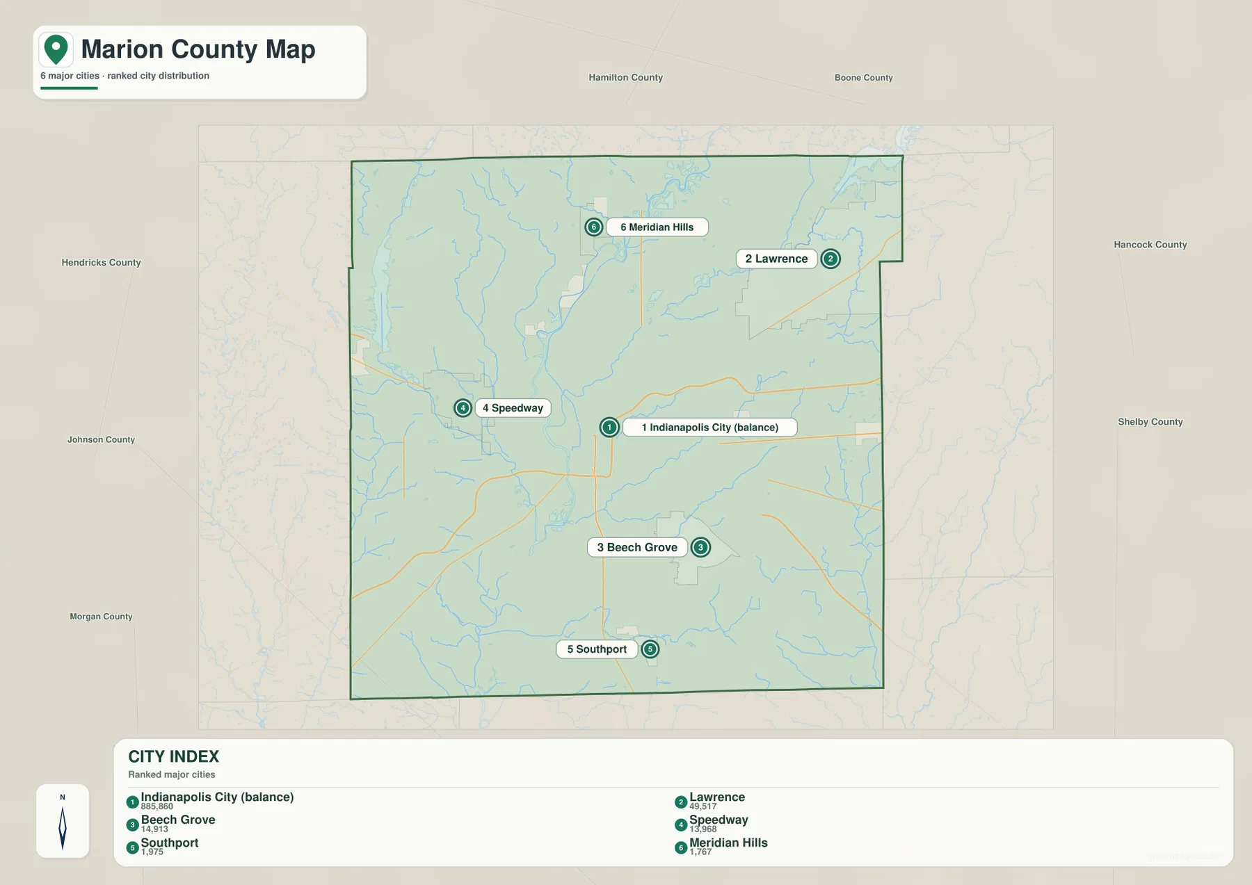
Lawrence is a clear second place in the printed index, yet the gap to Indianapolis remains enormous. Beech Grove and Speedway are close to one another in the printed values even though they lie on opposite sides of the central city. Southport and Meridian Hills are much smaller and work best as fine-scale location references rather than major county centers.
The detailed map contains additional names such as Williams Creek, Crows Nest, Rocky Ripple, Warren Park, Cumberland, Homecroft, and Clermont that do not appear in the six-place index. Use the general map whenever those smaller municipalities or road connections matter. Use the city index when you want a cleaner comparison of the six highlighted areas. Current demographic analysis should rely on a current official source rather than the printed values alone.
White River and Fall Creek create the strongest low corridors through the Indianapolis urban area
White River is the clearest water feature on the terrain-and-water map. It enters from the north, bends through the middle of Marion County, and continues toward the southwest. Sullivan Lake and West Lake help orient the west-central section around the White River and Eagle Creek drainage. Once the city labels disappear, the river’s long curving path becomes the easiest way to recognize the county center.
Fall Creek approaches from the northeast near Indian Lake and continues toward the White River side. Ravenswood Lake, Shore Co Lake, Lake Kesslerwood, and Maxinhall Lake appear as smaller nearby water landmarks. Indy Parks describes the White River Trail as following White River from Riverside Regional Park toward White River State Park, providing an official local example of how closely the river corridor is tied to Indianapolis.
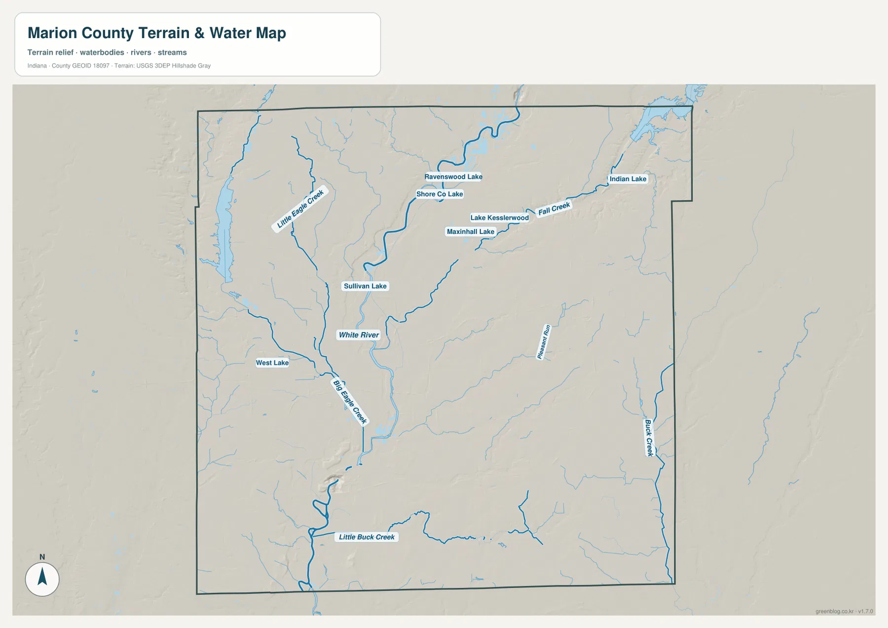
Little Eagle Creek descends through the northwest, while Big Eagle Creek runs through the western interior toward the White River side. West Lake and Sullivan Lake make those western drainage lines easier to relocate. This side of the county is a good example of how the water map can simplify a dense urban road map: the blue drainage lines remain recognizable even when most streets and municipal labels are removed.
Pleasant Run and Buck Creek divide parts of the eastern half, and Little Buck Creek provides a long southern reference. Rather than one river draining the entire urban area by itself, Marion County shows a network of creeks feeding and paralleling the White River corridor. Those smaller channels become even more useful on the elevation image because they often appear as low cuts through higher surrounding terrain.
The supplied water map is for geographic and terrain reference. It does not establish flood risk, current water level or quality, navigation rights, legal stream limits, or parcel boundaries. Anyone making a property, engineering, or hazard decision should consult the current USGS, FEMA, or Indianapolis/Marion County source designed for that specific purpose.
The supplied 86–279 m elevation legend places a long central lowland between higher western and eastern terrain
The elevation map’s legend reports an actual Marion County range of about 86 to 279 meters and a mean of 239 meters. Green indicates lower ground, while yellow, tan, and brown mark progressively higher terrain. The most obvious feature is the north-south green corridor associated with White River and nearby drainage. Higher ground spreads across both the western and eastern sides of that central lowland.
The White River valley broadens through the Indianapolis center, and Fall Creek adds another low approach from the northeast. When the water and elevation views are compared directly, the strongest named channels line up with elongated green corridors. That relationship is more useful than treating the entire Indianapolis urban area as a uniformly flat surface.
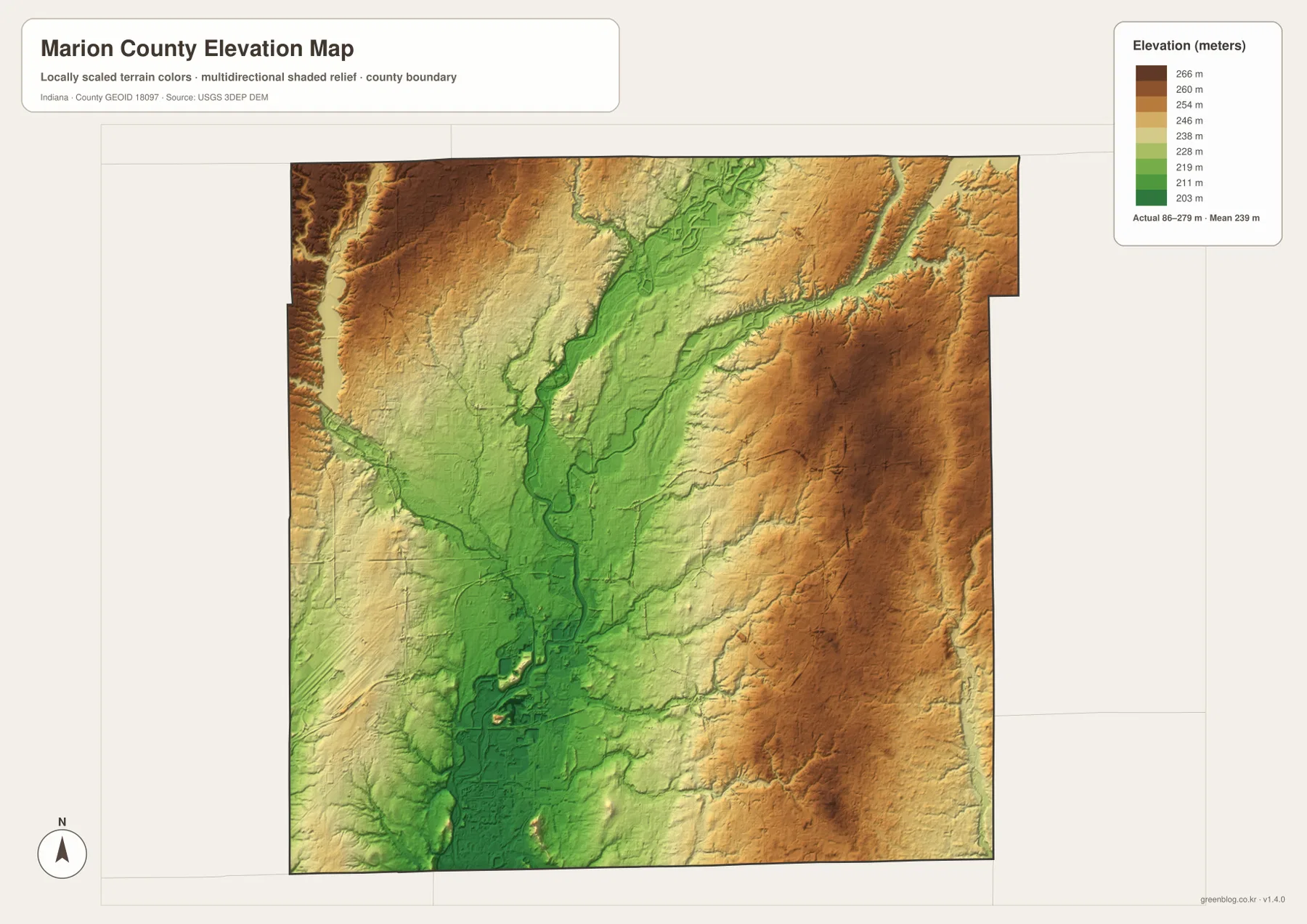
The western side rises toward broad tan and brown terrain near the county edge, while Big Eagle Creek and Little Eagle Creek carve lower lines back toward the center. Around Speedway and the west-central interior, the colors transition into greens and lighter tones before reaching the White River valley. This creates a stepped visual change from the outer high ground to the central lowland.
The east is also broadly elevated, especially through the east-central and northeastern sections. Fall Creek, Pleasant Run, and Buck Creek interrupt that higher surface with lower green valleys. The southern county remains largely within the central lowland but includes several small raised areas, so the bottom of the map is not a perfectly level basin.
This relief image is intended for county-scale comparison rather than site surveying. The elevation values come from the supplied map legend and are used here to describe relative terrain differences visible in that map. For a parcel, building pad, road grade, or drainage project, use source elevation data such as the USGS 3D Elevation Program or a qualified survey rather than this generalized image.
Keep Indianapolis fixed as the reference point while switching between city, river, and relief views
For settlements and transport context, begin with the general map. Find Lawrence in the northeast, Speedway in the west, Beech Grove in the southeast, and Southport in the south while keeping Indianapolis at the center. The dense road and rail network makes the detailed map the best choice for understanding how the smaller municipalities sit within the broader urban county.
The city index is useful when you want to strip that complexity down to six highlighted places. Indianapolis City (balance) dominates the printed values, Lawrence provides the northeastern second center, Beech Grove and Speedway form opposite-side mid-sized references, and Southport and Meridian Hills provide smaller markers. For current population totals, consult a current official dataset rather than treating the index as a live demographic table.
For physical geography, locate White River first and then add Fall Creek and the Eagle Creek system. Switch to the elevation map at those same positions and the central lowland becomes obvious between the higher western and eastern terrain. Pleasant Run, Buck Creek, and Little Buck Creek can then be used to trace additional low corridors across the eastern and southern parts of the county.
The WebP images on this page are reduced previews. The download archive contains four original 3638×2572-pixel JPG files: the general county map, city index, terrain-and-water map, and elevation map. The larger originals are better for printing or reading small municipality, rail, road, creek, and lake labels.
A useful comparison is to keep Indianapolis fixed as the center. Find Lawrence, Speedway, and Beech Grove on the general map, compare the highlighted municipalities on the city index, move to the water view to trace White River and Fall Creek, and finish on the elevation map by comparing the central lowland with the higher ground on both sides. That sequence turns a dense metropolitan map into a much clearer set of geographic relationships.
Frequently Asked Questions
Which places have the largest values on the supplied city index?
Indianapolis City (balance) is printed at 885,860, followed by Lawrence at 49,517, Beech Grove at 14,913, Speedway at 13,968, Southport at 1,975, and Meridian Hills at 1,767. These figures belong to the supplied map edition rather than a live population feed.
Which waterways are easiest to recognize?
White River is the strongest central reference, with Fall Creek entering from the northeast. Big Eagle Creek and Little Eagle Creek organize the west, Pleasant Run and Buck Creek mark the east, and Little Buck Creek lies in the south. The map shows geographic location rather than flood status, current water conditions, or legal water boundaries.
Can the supplied 86–279 m elevation range be used for exact site measurements?
No. The map legend reports that county-wide range and a mean of 239 meters, and the image is intended for comparing the White River lowland with higher surrounding terrain. For a Marion County parcel, building site, road-grade question, or drainage project, use original elevation data or a qualified survey instead of this county-scale relief image.
Map File Information
The Marion County ZIP combines the general road-and-place map, six-place city index, terrain-and-water map, and elevation map as full-resolution JPG originals.
- File Type: ZIP containing four 3638×2572px JPG files
Related Maps
Sources and References
The article is based primarily on the supplied Marion County map set and asset manifest. The following official sources provide Indianapolis–Marion County, White River, boundary, hydrography, and elevation context.
- Indy.gov – Indianapolis & Marion County – official digital city hall for Indianapolis and Marion County
- Indy Parks – White River Trail – official information on the White River corridor through Indianapolis
- Indy Parks – Holliday Park – official Marion County park information along White River
- U.S. Census Bureau TIGER/Line Shapefiles – boundary reference for Marion County and its municipal framework
- USGS National Hydrography – hydrography reference for White River, Fall Creek, Eagle Creek, and smaller channels
- USGS 3D Elevation Program – source terrain data for checking precise elevations beyond the county-scale map
Green Map creates custom-edited map images using open geographic data sources such as geoBoundaries, Natural Earth, OpenStreetMap, and government open data.
These maps are edited visual materials, not raw data files, and are provided for education, documents, presentations, and graphic reference.