Fulton County sits in northern Indiana, with Rochester near the center of the county and smaller communities spread in several directions. Akron lies to the east, Kewanna to the west, and Fulton to the south, while places such as Talma, Leiters Ford, and Lake Bruce help fill in the northern half of the map. This Fulton County Indiana Map page separates roads and settlements, city connections, waterways, and elevation into clear views. The same maps shown here are also available as high-resolution JPG files in one ZIP download near the end of the article.
Rochester is the easiest place to begin. On the general county map, routes marked 14 and 31 cross near the city, making Rochester a useful reference point for finding Akron, Kewanna, Talma, and the southern part of the county. The city-connections map then simplifies the picture by showing Rochester as the hub for three nearby communities. A separate terrain-and-water map brings the Tippecanoe River, Manitou Lake, and named creeks into focus, while the elevation map shows how lower western areas contrast with higher ground in the north and east.
The supplied elevation map lists an actual countywide range of 217 to 313 meters and a mean elevation of 240 meters. The water map labels the Tippecanoe River along with Eddy Creek, Mud Creek, Mill Creek, Grassy Creek, several ditches and smaller streams, and a group of lakes that includes Manitou Lake, Nyona Lake, Town Lake, and Mud Lake. These maps are designed for county-scale orientation and comparison. They should not be treated as parcel, flood-regulation, navigation, engineering, or survey products.
Table of Contents
Rochester provides the clearest reference point for roads and settlements
The general county map puts Rochester in the most visually prominent position. Its built-up area is shaded near the north-central part of Fulton County, and the numbered roads around it make the city easy to relocate after looking at the other maps. The road marked 14 runs generally east and west through the Rochester area, while 31 forms a strong north-south reference. Together they give readers a simple framework for understanding where the other towns sit without turning the map into a turn-by-turn navigation guide.
Kewanna appears west of Rochester, close to another north-south road line. Farther northwest, Leiters Ford is labeled near a small green settlement area, and Lake Bruce appears along the western side of the county. To the east, Akron sits close to the entrance of Fulton County’s eastern extension, with the road marked 19 continuing through that part of the map. Talma lies north of Rochester and west of the eastern extension, adding another useful point for understanding the northern section of the county.
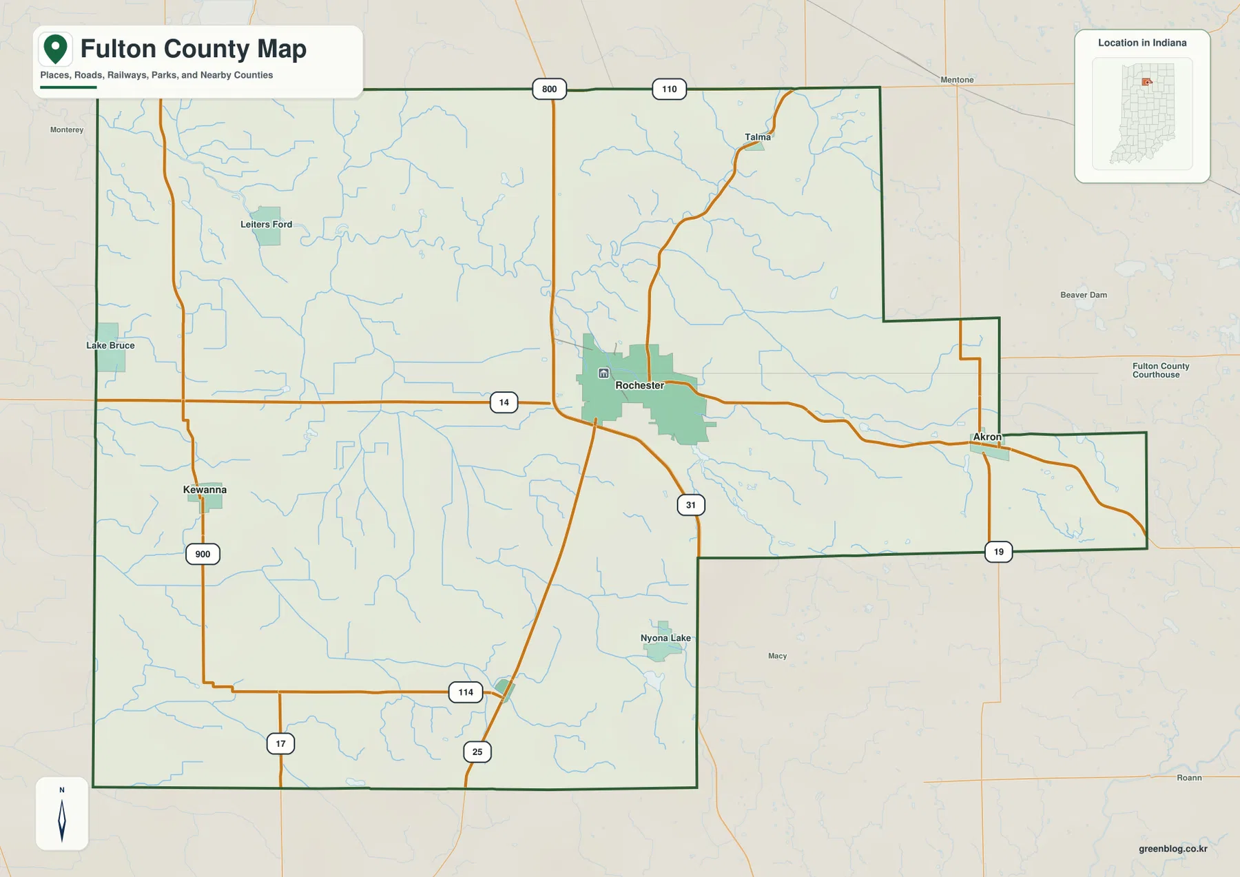
The county outline itself is worth noticing. Much of the western and southern area forms a broad block, but the eastern side steps outward in two sections rather than following one straight edge. Akron is positioned near the point where this extension begins. Remembering that shape makes it easier to recognize the county on the water and elevation maps, where roads and town names are no longer the dominant visual features.
Several road numbers are visible besides 14 and 31, including 19, 25, 17, and 114, along with local-looking numbers such as 800 and 110 in the north. The map is useful for seeing the direction of these corridors and which communities they pass near. It does not identify every road classification, current construction project, traffic restriction, or driving condition. Anyone planning a trip should use an up-to-date road source for those details.
Blue lines show many small streams and drainage features across the county, even on the general map. They are especially dense north and west of Rochester and continue into the eastern portion of the county. Most are intentionally subdued so that roads and settlements remain readable. Readers who want to identify individual waterways will get more from the dedicated terrain-and-water map later in the page.
City connections show Akron and Fulton 9 miles from the Rochester hub
The city-connections map removes many secondary labels and focuses on Rochester, Akron, Kewanna, and Fulton. Rochester is marked as the hub. The map gives a direct distance of 9 miles from Rochester to Akron, 9 miles from Rochester to Fulton, and 12 miles from Rochester to Kewanna. These are straight-line distances between the mapped points, not driving distances along the road network. Road mileage and travel time can be longer and should be checked separately.
The simplified layout makes direction more obvious than on the general map. Akron is east of Rochester, Kewanna is west, and Fulton is to the south. Rochester therefore works as a practical center for comparing the three communities even though Fulton County contains additional named places. The map is especially useful when a reader wants to understand relative placement before returning to the more detailed road map.
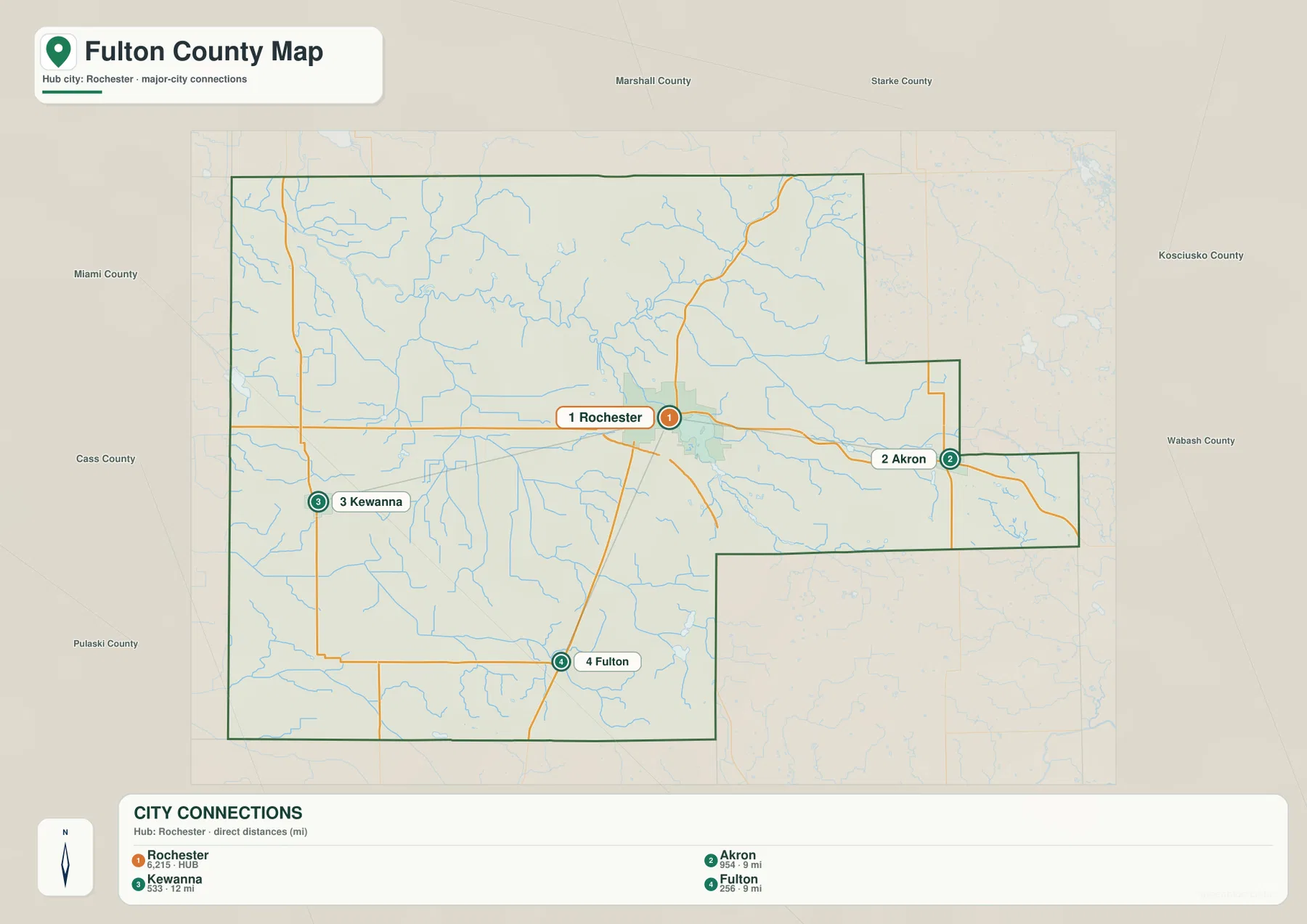
Names of surrounding counties appear outside the Fulton County boundary. Marshall County and Starke County are shown to the north, Kosciusko County and Wabash County to the east, and Miami County, Cass County, and Pulaski County on the western and southwestern sides. These labels help place Fulton County within the broader northern Indiana landscape. They also make it clear why communities near the county edge may be closer to places outside Fulton County than to some communities within it.
The connection panel includes numbers next to the town names: Rochester 6,215, Akron 954, Kewanna 533, and Fulton 256. On this page, those values are treated only as the city-index values printed on the supplied map rather than as a claim about current population. Population figures change over time, and a reader who needs current demographic data should verify them in a current Census product. The spatial relationship among the four places, rather than the age of those index numbers, is the main purpose of the map.
Using the general and city maps together works well. First locate the community on the simple connections view, then return to the detailed map to see the road lines and the county boundary around it. This is particularly helpful for Akron because it lies near the eastern extension, and for Kewanna because it sits well west of Rochester. Fulton, in the southern part of the county, becomes easier to place when the north-south road lines are visible again.
The Tippecanoe River and Manitou Lake anchor the water map
The terrain-and-water map gives the Tippecanoe River the strongest blue line in the northern half of the county. Its bends make it easy to follow across the map, and smaller waterways connect to it from several directions. Eddy Creek is labeled in the northwest. Smith Ditch and Chippewanuck Creek are labeled farther east, while other unnamed tributaries branch through the surrounding terrain. The combination of water lines and shaded relief makes the river valleys easier to recognize than on the road-focused map.
Manitou Lake is another major reference point. It appears near the central part of the county and is large enough to stand out immediately. South of it, the map labels Lake Mt Zion, Nyona Lake, and S Mud Lake. Farther southwest, Fletcher Lake appears close to the county’s lower edge. In the eastern extension, Town Lake and Mud Lake provide additional landmarks. These labels show that the county’s visible surface water is distributed across several areas rather than concentrated in a single lake district.
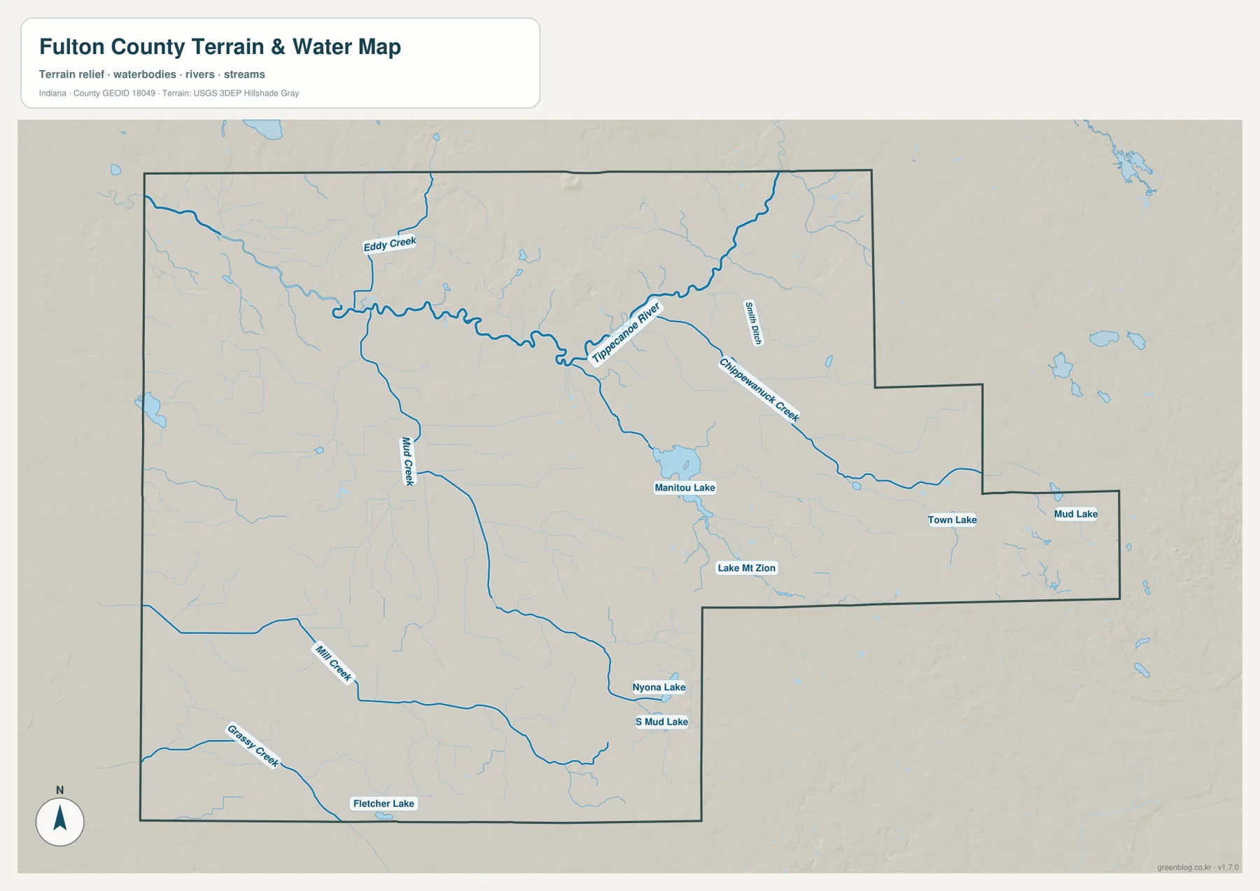
In the southern and western portions of the county, the map labels Mud Creek, Mill Creek, and Grassy Creek. These waterways are thinner than the Tippecanoe River but remain useful for matching low terrain with named drainage features. When the general map looks crowded with many small blue lines, the water map makes it easier to separate the larger named features from minor branches.
Comparing this map with the elevation view reveals a simple relationship: many stream corridors correspond with lower strips of terrain. The Tippecanoe River valley can be followed through lower shades in several places, and smaller creeks also occupy visible depressions. The comparison is most useful at the county scale. It does not establish flood elevations, channel ownership, navigability, water quality, or legal shoreline boundaries.
Readers looking for a flood map should use an official flood-hazard source instead. The blue features here are reference waterways, and the relief shading is included to explain the surrounding landform. For current hydrography names and mapped water features, the USGS National Hydrography resources linked in the source section provide an appropriate official starting point.
Elevation ranges from 217 to 313 meters, with higher ground in the north and east
The elevation map reports an actual range of 217 to 313 meters and a mean of 240 meters for Fulton County. Green tones represent lower ground, while yellow, orange, and brown tones mark progressively higher terrain on the locally scaled map. The western and southwestern parts of the county contain broad green areas. In contrast, a prominent patch of higher brown terrain appears in the north-central section, and elevated colors also become common in the eastern extension.
The north-central high ground is broken by many narrow valleys, which appear as greener lines cutting through the warmer colors. The western half is generally lower but still contains subtle ridges and stream channels rather than a perfectly flat surface. The eastern side changes more quickly between lower valleys and higher patches, especially near the outer boundary. This makes the elevation map useful for recognizing broad relief without needing individual spot-elevation labels.
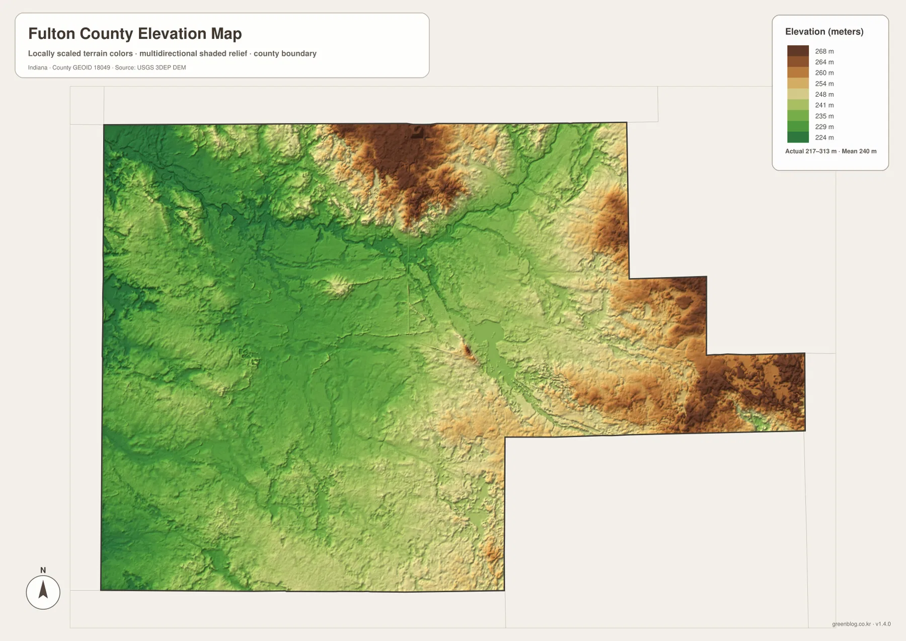
The river and lake map becomes more informative when viewed beside the elevation colors. Lower corridors follow parts of the Tippecanoe River and several tributaries. Around Manitou Lake and the chain of smaller lakes to the south, the terrain is generally gentler than the strongest high-ground areas visible farther north and east. This is a visual county-scale comparison, not a measurement of the exact elevation of a shoreline, road, building, or parcel.
The legend is intended to make relative differences easy to see. A user should not select a color and treat it as a survey-grade elevation for a specific point. Engineering design, drainage work, construction planning, and legal surveying require the underlying elevation data at an appropriate resolution or a field survey. The USGS 3D Elevation Program is a better source when precise elevation data are needed.
Combining the maps gives a clearer picture of Fulton County
A place-based approach makes the set easier to use than reading each map in isolation. Start with Rochester and the roads around it, then compare where Akron, Kewanna, and Fulton sit in relation to the hub. From there, follow the nearby Tippecanoe River and Manitou Lake before checking the elevation colors around the same area. Moving through the maps this way connects settlements, water, and relief without turning the article into a list of map types.
A practical way to use the set is to follow one place through all four views. Start with Rochester on the general map and note the surrounding road lines. Move to the city-connections map to see how Akron, Kewanna, and Fulton relate to it. Then locate the Tippecanoe River and Manitou Lake on the water map. Finally, compare the same area with the elevation colors to see how river valleys and nearby higher ground fit together. This sequence turns several separate map layers into one understandable picture of the county.
Akron offers another example. Its position near the eastern extension is clear on the general map, the city map places it 9 straight-line miles from Rochester, and the water map shows named waterways and lakes in the eastern part of the county. The elevation map then shows that this extension contains substantial areas of higher terrain as well as lower stream corridors. Looking at the same place from these different perspectives prevents the map from becoming a list of unrelated features.
For printing, classroom work, local-history notes, presentations, or a personal reference collection, the high-resolution JPG files are more convenient than the WebP previews embedded on the page. The ZIP contains the general county map, city-connections map, terrain-and-water map, and elevation map as separate JPG files. That makes it possible to enlarge one map without carrying all the other information into the same image. The higher resolution improves readability, but it does not change the intended county-scale accuracy of the source maps.
The downloadable JPGs are suitable for general reference and visual comparison of towns, roads, water, and terrain. They should not be used to establish property ownership, zoning, parcel boundaries, flood compliance, construction grades, or any other legal or engineering determination. For those purposes, consult the current records and data maintained by the responsible public agency.
Frequently Asked Questions
Where are Akron, Kewanna, and Fulton in relation to Rochester?
Rochester is the central hub on the city-connections map. Akron lies to the east, Kewanna to the west, and Fulton to the south. The map gives straight-line distances of 9 miles from Rochester to Akron, 12 miles to Kewanna, and 9 miles to Fulton. These are direct distances between mapped points rather than driving distances on the road network.
Which map is best for finding the Tippecanoe River and Manitou Lake?
The terrain-and-water map is the clearest choice. It emphasizes the Tippecanoe River and labels Manitou Lake along with Eddy Creek, Mud Creek, Mill Creek, Nyona Lake, Town Lake, Mud Lake, and other water features. The elevation map can then be used beside it to compare those waterways with lower valleys and surrounding higher terrain.
Can the 217–313 meter elevation range be used as an exact parcel elevation?
No. The 217–313 meter range and 240 meter mean describe the supplied county-scale elevation map. They are useful for comparing broad high and low areas but do not provide a surveyed elevation for a specific parcel, road point, building site, or shoreline. Precise work should use appropriate USGS elevation data or a professional survey.
Map File Information
This ZIP contains the high-resolution JPG versions of the Fulton County general map, city-connections map, terrain-and-water map, and elevation map. Use them when you need larger images for printing, documents, or closer inspection than the on-page previews provide.
- Included Files: 4 high-resolution JPG maps
Related Maps
Sources and References
For authoritative boundary, hydrography, and elevation data beyond the simplified maps on this page, the following official resources are useful starting points.
Green Map creates custom-edited map images using open geographic data sources such as geoBoundaries, Natural Earth, OpenStreetMap, and government open data.
These maps are edited visual materials, not raw data files, and are provided for education, documents, presentations, and graphic reference.