You can download the high-resolution A3 JPG maps on this page together in one ZIP file. Gibson County sits in southwestern Indiana, where Princeton serves as the county seat and a practical reference point for the surrounding towns, highways, rivers, and lowlands. The western side reaches the Illinois line along the Wabash River, while the Patoka and White rivers shape the northern part of the county. This Gibson County Indiana Map page also provides WebP previews for quick viewing, with separate views for roads and places, ranked cities, terrain and water, and elevation.
Princeton is a useful place to begin because the general map shows roads radiating north, south, east, and west from its urban area. Patoka and Hazleton lie to the north, Fort Branch and Haubstadt to the south, Oakland City and Francisco to the east, and Owensville to the southwest. The official Gibson County site also identifies Princeton as the county seat and describes the county as part of southwestern Indiana. Reading outward from Princeton turns the county outline from an unfamiliar shape into a set of recognizable directions and destinations.
The physical landscape changes noticeably across the same area. The supplied elevation map reports an actual county range of 84 to 194 meters with a mean of 135 meters. Broad green lowland dominates the Wabash side in the west, while broken higher terrain becomes more common toward the northeast, east, and parts of the south. The water map adds the Patoka River, White River, Black River, Pigeon Creek, and many smaller creeks and ditches, making it easier to connect river corridors with the lower portions of the terrain.
Table of Contents
Princeton anchors the road network while the county opens toward the Wabash
On the general map, Princeton is the strongest visual center. Its green urban footprint sits north of the county midpoint, with a north-south route continuing toward Patoka and Hazleton and another major corridor running south toward Fort Branch and Haubstadt. Eastbound roads reach Francisco and Oakland City, while the western side opens toward Owensville, Johnson, and the broad lowland near the Illinois line. This arrangement makes Princeton useful for orienting the map even before individual highway numbers are read.
The southern highway pattern is especially important for understanding how Gibson County connects to the wider region. Gibson County’s official website highlights the intersection of Interstate 64 with U.S. 41 and another intersection of Interstate 64 with Interstate 69. Those corridors appear in the southern half of the supplied map: 64 runs east-west near the bottom, 41 crosses north-south near Haubstadt and Fort Branch, and 69 is farther east. The map is not a turn-by-turn navigation product, but it clearly shows why the southern part of the county has several strong regional routes.
North of Princeton, the shape of the county becomes less regular. Hazleton sits near the upper boundary, and Patoka lies south of it on the route back toward Princeton. On the eastern side, Oakland City lies close to a straighter outer boundary and Francisco appears between Oakland City and Princeton. Smaller places such as Mackey, Somerville, Buckskin, and Johnson add local reference points that are useful when the large towns alone do not provide enough detail.
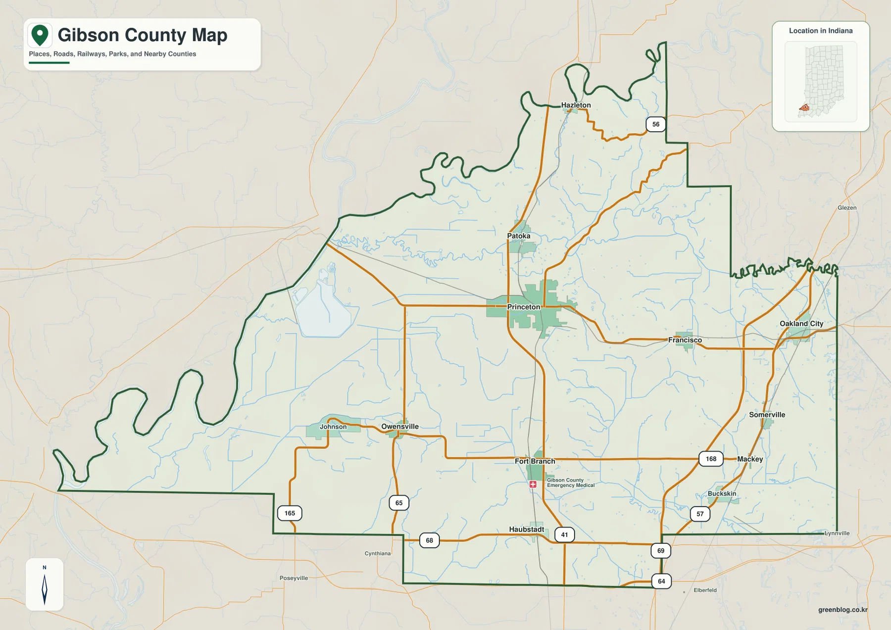
The western boundary is visually different from the straighter lines on much of the east. Indiana public records list the Wabash River as a navigable waterway throughout Gibson County, and a state regulatory filing describes the river as the county’s western boundary with Illinois. That explains the long sequence of bends along the left side of the county outline. The boundary follows the river rather than a simple straight survey line, while portions of the eastern edge are comparatively angular.
Route labels such as 56, 57, 64, 65, 68, 69, 165, and 168 help tie smaller places to the larger network. They are most useful as orientation markers rather than as a substitute for current traffic information. Construction, closures, speed limits, and exact driving routes can change and should be checked with current transportation sources. For the purpose of this page, the general map works best for seeing how towns, roads, county edges, and the larger water network share the same space.
The city index spreads six major places across the county instead of one urban cluster
The ranked-city map removes most of the road detail and emphasizes six places. Its CITY INDEX lists Princeton first, followed by Fort Branch, Oakland City, Haubstadt, Owensville, and Patoka. The figures printed beside those names are 8,372 for Princeton, 3,021 for Fort Branch, 2,262 for Oakland City, 1,905 for Haubstadt, 1,156 for Owensville, and 737 for Patoka. This article treats those numbers as values printed on the supplied map rather than claiming that they are the latest population estimates. Current demographic questions should be checked against a current Census source.
The spatial pattern matters more than the ranking itself. Princeton is slightly north of the middle, Fort Branch and Haubstadt form a clear southern pair, Oakland City occupies the eastern side, Owensville sits southwest of the center, and Patoka is north of Princeton. The six locations therefore describe several different parts of Gibson County. The map does not suggest a single continuous urban strip; instead, it shows a set of separated towns linked by the road system and the agricultural landscape between them.
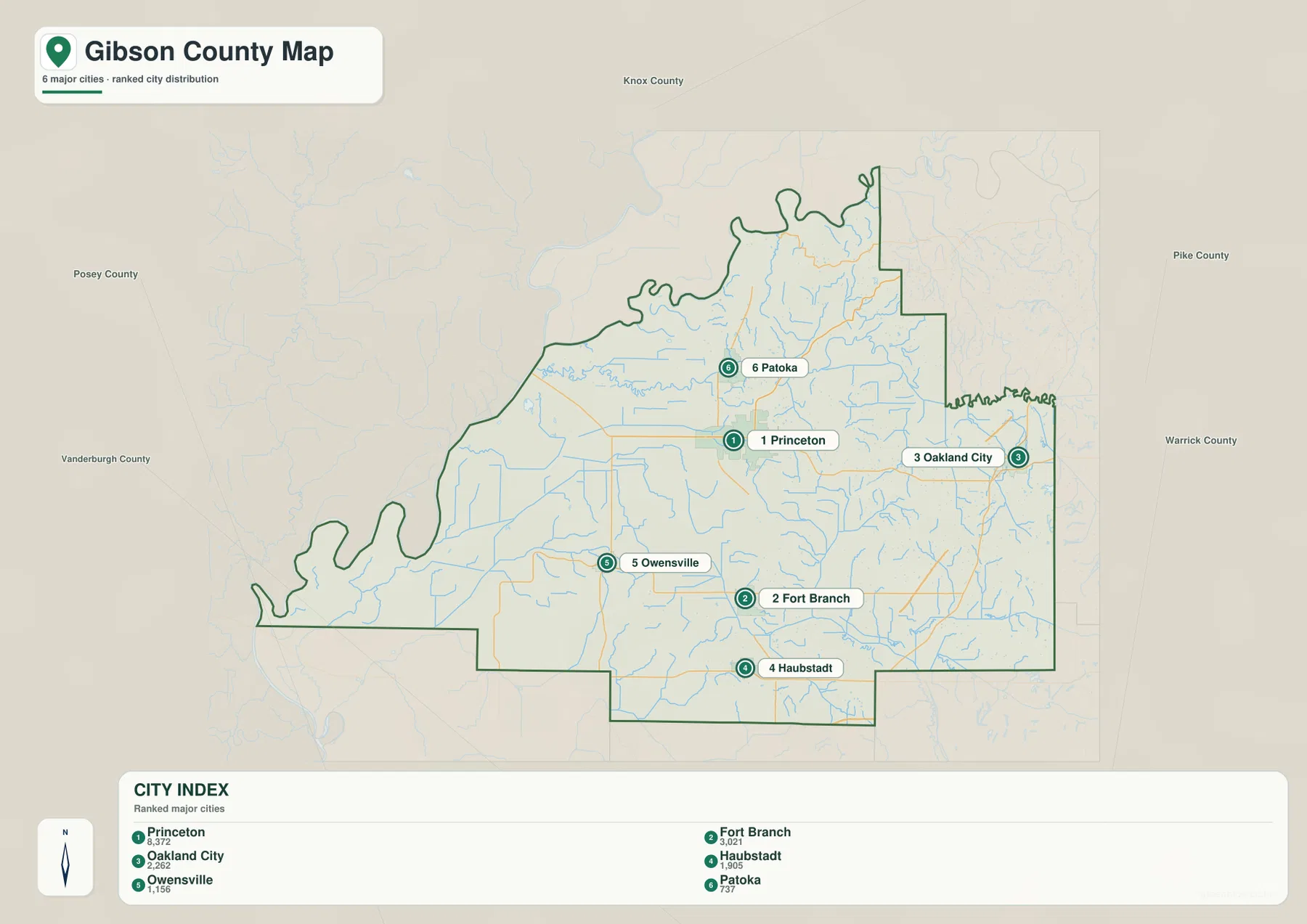
The Princeton-Fort Branch-Haubstadt relationship is particularly easy to see. Fort Branch lies south of Princeton and Haubstadt lies farther south, close to the 64 corridor. That vertical arrangement matches the north-south road pattern on the general map. Oakland City provides a different reference because it sits well to the east, while Owensville shifts attention toward the western lowlands. Patoka adds a northern point that helps balance the map beyond the more heavily traveled south-central area.
Hazleton is visible on the general map but is not one of the six ranked labels on the city map. That difference illustrates why the two images serve different purposes. The ranked map is a fast comparison of six major places, whereas the general map preserves more communities, roads, and contextual features. Switching between the two prevents a simplified city index from being mistaken for a complete list of every settlement in Gibson County.
Neighboring county labels around the city map also help place Gibson County within southwestern Indiana. Knox County appears to the north, with Pike and Warrick counties to the east. The western side reaches the state line, and the broader region continues south toward Vanderburgh and Posey counties. These labels are useful for orientation, but the supplied map remains a county-scale reference and should not be used to determine parcel ownership or a precise legal boundary.
Patoka and White rivers converge toward the Wabash side of the county
The terrain-and-water map makes the Patoka River the most prominent named waterway inside the county. It enters from the east, bends across the northern half, and continues west toward the Wabash system. The U.S. Fish and Wildlife Service describes Patoka River National Wildlife Refuge as extending along the lower Patoka River in Pike and Gibson counties, with its headquarters in Oakland City. That federal refuge context fits the map well because Oakland City lies near the eastern side of Gibson County while the river crosses the northern part of the same landscape.
The White River is another major reference in the northwest. A USGS station page for the White River at Hazleton identifies the site on the Gibson County-Knox County line. On the supplied map, the White River occupies the upper-left area while the Patoka River lies farther south. Indiana’s navigable-waterways roster includes the Wabash, White, and Patoka rivers for Gibson County, confirming that all three are significant named waterways in the county’s geography.
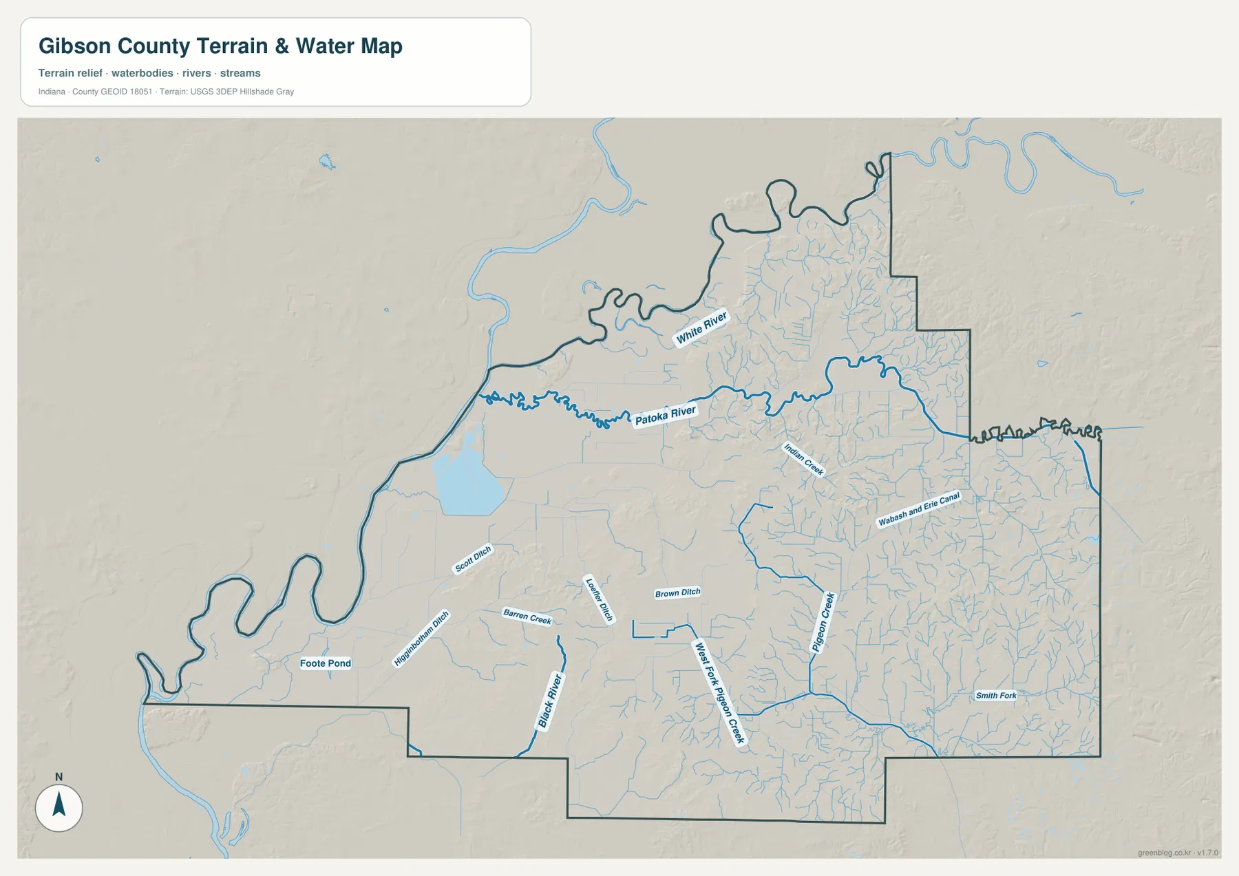
Smaller drainage features become especially dense in the west and south. The map labels Scott Ditch, Higginbotham Ditch, Barren Creek, Black River, Locust Ditch, and Brown Ditch on the western half, while Pigeon Creek, West Fork Pigeon Creek, and Smith Fork appear in the south and east. Numerous thin blue branches connect these named features. They are useful for understanding the general drainage network, but their presence does not identify flood-hazard zones, legal drainage easements, water quality, or navigable limits.
Princeton itself sits south of the Patoka River main stem. Moving west from the city leads toward a broader, lower landscape drained by the Black River and several ditches before reaching the Wabash side. To the east and southeast, the water network becomes a finer mesh around Pigeon Creek and its branches. The map also shows Foote Pond and a larger water body in the western half, giving additional reference points in a part of the county where the general road map is otherwise relatively open.
Relief shading behind the water lines is important. The White and Patoka river corridors occupy broad low areas, while many eastern tributaries cut through more broken terrain. This creates a visible transition from wider lowland in the west and northwest to shorter ridges and valleys toward the east. The pattern becomes clearer on the elevation map, where the same transition is expressed through green, yellow, orange, and brown height classes rather than through stream lines.
An 84–194 meter range separates the western floodplain from higher broken ground
The elevation map states an actual Gibson County range of 84 to 194 meters and a mean elevation of 135 meters. Its locally scaled colors place lower terrain in green and higher terrain in yellow, orange, and brown. The largest continuous low area lies along the western side, where the Wabash River boundary and lower Patoka drainage approach one another. Higher colors are much more common in the northeast and east, with additional ridges appearing in the south-central and southeastern portions of the county.
The color legend itself emphasizes steps from about 115 to 163 meters, while the map separately reports the wider actual minimum and maximum. That distinction is useful when interpreting the image. A green or brown patch should be read as relatively low or high within this county-scale rendering rather than as an exact surveyed elevation for a single point. The broad contrast is reliable for visual orientation, but the precise height of a road, house site, field corner, or stream bank requires the underlying elevation dataset or a survey.
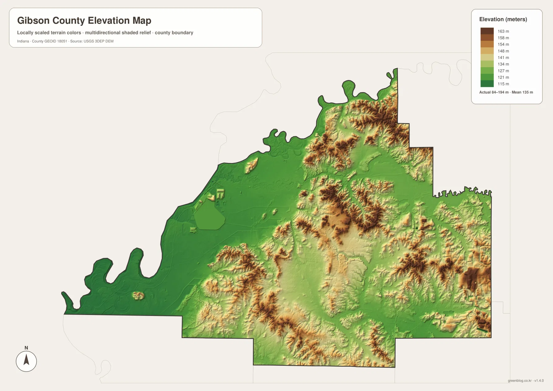
The river map helps explain the green areas. The Patoka and White rivers approach the Wabash across broad lower terrain, and many western drainage channels occupy the same low side of the county. East of Princeton, the elevation surface becomes more dissected, with narrow green valleys separating higher ridges. The difference is not a simple west-east wall; low stream corridors continue through the eastern half, and isolated higher patches also rise from parts of the west. Still, the county-wide contrast is strong enough to recognize immediately.
Princeton occupies a useful middle position between the broad western lowland and the more broken terrain toward Oakland City and the eastern boundary. Fort Branch and Haubstadt in the south also sit in a mixed landscape where small ridges and lower drainage corridors alternate. Following these towns from the city map to the elevation map makes the relief easier to understand than reading the color legend alone.
This elevation surface is intended for regional comparison, not engineering. It cannot establish construction grade, drainage design, property elevation, or a legal flood elevation. The USGS 3D Elevation Program is the appropriate official starting point when a user needs the underlying elevation data at a useful resolution. For ordinary map reading, the supplied elevation image is most helpful for seeing where the county is broadly low, where it rises, and how those changes relate to rivers and towns.
Following the same town across all four maps gives the clearest picture
The four views become more useful when a reader follows one location instead of treating them as unrelated graphics. Start with Princeton on the general map and note its road connections. Move to the ranked-city map and see that Princeton is the first listed place. Then use the water map to locate the Patoka River north of the city and the drainage network spreading westward. Finally, check the elevation map to see how the land broadens into lower terrain toward the Wabash side and rises more irregularly toward the east.
Oakland City produces a different sequence. It lies close to the eastern side on the general map and ranks third on the city map. The Patoka River is north of it, while Pigeon Creek-related drainage occupies parts of the south and east. On the elevation map, this side of Gibson County contains far more orange and brown terrain than the broad western lowland. The same place therefore provides a useful example of how settlement location, water, and relief can be read together.
Owensville is a good western example. The general map places it southwest of Princeton near Route 65, and the city map ranks it fifth. The water map shows Black River, Barren Creek, and several ditches across this part of the county, while the elevation map shows extensive low green ground toward the Wabash. Comparing these views explains the western side through actual local features rather than through a generic description of “flat land.”
For printing, classroom reference, local-history notes, presentations, or a personal map archive, the downloadable JPGs are more practical than the smaller WebP previews embedded in the page. The files are separated by purpose, so a reader can enlarge the road-and-place map without the elevation colors, or use the water map without carrying every city label into the same image. The higher resolution improves legibility, but it does not change the intended county-scale accuracy of the maps.
The JPG files are reference maps. They should not be used to prove property ownership, zoning, parcel lines, flood compliance, construction elevations, navigation rights, or other legal and engineering conditions. Those questions require current records from the responsible county, state, federal, or professional source.
Frequently Asked Questions
How is Princeton positioned relative to the other major places on the Gibson County maps?
Princeton is slightly north of the county center and is ranked first on the supplied city index. Fort Branch and Haubstadt lie to the south, Oakland City lies east, Owensville lies southwest, and Patoka lies north. The general map also shows several roads converging around Princeton, making it the easiest reference point for locating the other communities.
Which map best shows the Patoka River and its relationship to the Wabash side?
The terrain-and-water map is the best starting point. It traces the Patoka River across the northern half of Gibson County and shows the White River in the northwest along with Black River, Pigeon Creek, and many smaller tributaries. Pairing that map with the elevation view makes the broad low ground toward the western Wabash boundary especially clear.
Can the 84–194 meter elevation range be used as the exact height of a property?
No. The 84–194 meter range and 135 meter mean describe the supplied county-scale elevation map. The colors are designed to compare broad high and low areas, not to provide a surveyed elevation for an individual parcel, building, road point, or stream bank. Use appropriate USGS elevation data or a professional survey when precise values are required.
Map File Information
The ZIP contains high-resolution JPG versions of the Gibson County general map, ranked-city map, terrain-and-water map, and elevation map. Use the archive when you need a larger image for printing, documents, or closer map reading.
- Included Files: 4 high-resolution JPG maps
Related Maps
Sources and References
The article is based primarily on the features visible in the supplied Gibson County maps. The following official sources provide additional county, hydrography, boundary, refuge, and elevation context.
- Gibson County official website – About Gibson County
- Indiana State Library – Gibson County Research Guide
- U.S. Fish & Wildlife Service – Patoka River National Wildlife Refuge and Management Area
- U.S. Census Bureau – TIGER/Line Shapefiles
- USGS – National Hydrography
- USGS – 3D Elevation Program
Green Map creates custom-edited map images using open geographic data sources such as geoBoundaries, Natural Earth, OpenStreetMap, and government open data.
These maps are edited visual materials, not raw data files, and are provided for education, documents, presentations, and graphic reference.