You can download the original high-resolution JPG map set for Franklin County as a ZIP file from the map file box on this page. The lighter WebP previews below explain an eastern Indiana county shaped by river valleys, uplands, small towns, and roads that converge around Brookville. This Franklin County Indiana Map guide places Brookville in relation to Metamora, Laurel, Oldenburg, Cedar Grove, Mount Carmel, and other communities, then uses the water and elevation views to show why the Whitewater River system has such a strong influence on the county’s landscape.
Brookville is the best starting point for reading the set. On the general county map, it lies a little east of the county’s center, with Metamora to the west, Mount Carmel to the east, Cedar Grove to the southeast, and Laurel to the northwest. Several numbered routes approach or leave Brookville in different directions, so the town works as a practical reference point when locating smaller communities. The same area becomes even more important on the water and elevation maps because major branches of the Whitewater River system meet near Brookville.
The Town of Brookville’s history page describes the community as occupying both higher ground and a lower river plain at the junction of the East and West forks of the Whitewater River. That description matches the supplied terrain: low green corridors meet around Brookville on the elevation map, while surrounding ridges rise sharply away from the valley. West of Brookville, Metamora adds another water-related feature to the county story. The Whitewater Canal is labeled on the supplied map, and the Indiana State Museum identifies Metamora as the home of the Whitewater Canal State Historic Site.
These maps are meant for county-scale orientation rather than parcel, flood-regulation, or engineering decisions. They are most useful when read together: use the general map to find communities and roads, the city map to compare selected places with Brookville, the terrain-and-water map to identify named rivers and creeks, and the elevation map to see how those waterways occupy lower ground between the uplands. That sequence gives a clear picture of Franklin County without requiring specialized GIS knowledge.
Table of Contents
Roads radiate from Brookville toward Metamora, Mount Carmel, and the southern towns
The general county map contains the widest range of place names, so it is the most useful view for getting oriented. Brookville sits near the middle-right of the county outline. Route 101 approaches from the north, the road toward Metamora runs west, Route 252 continues east toward Mount Carmel, and Routes 1 and 52 appear farther south near Cedar Grove and New Trenton. Rather than treating every numbered line as a route-planning instruction, it is better to use them as visual anchors for understanding how the communities are arranged.
West of Brookville, Metamora stands out where several local roads and waterways meet. Laurel lies farther northwest, while Peppertown is shown south-southwest of Metamora. The southwest corner has a different pattern: Oldenburg and Batesville sit close to the angled county edge, and Route 229 runs through that part of the map. Route numbers 74 and 46 are also visible near Batesville, giving the southwest corner a denser transportation appearance than some of the rural interior.
Southeast of Brookville, Cedar Grove and New Trenton provide another pair of useful landmarks. Cedar Grove lies along a north-south road corridor, with New Trenton closer to the southern edge. Mount Carmel, meanwhile, is well east of Brookville along Route 252. Taken together, these places show that Franklin County does not have one straight settlement corridor. Communities occupy different valleys and road approaches, with Brookville acting as the most obvious central reference.
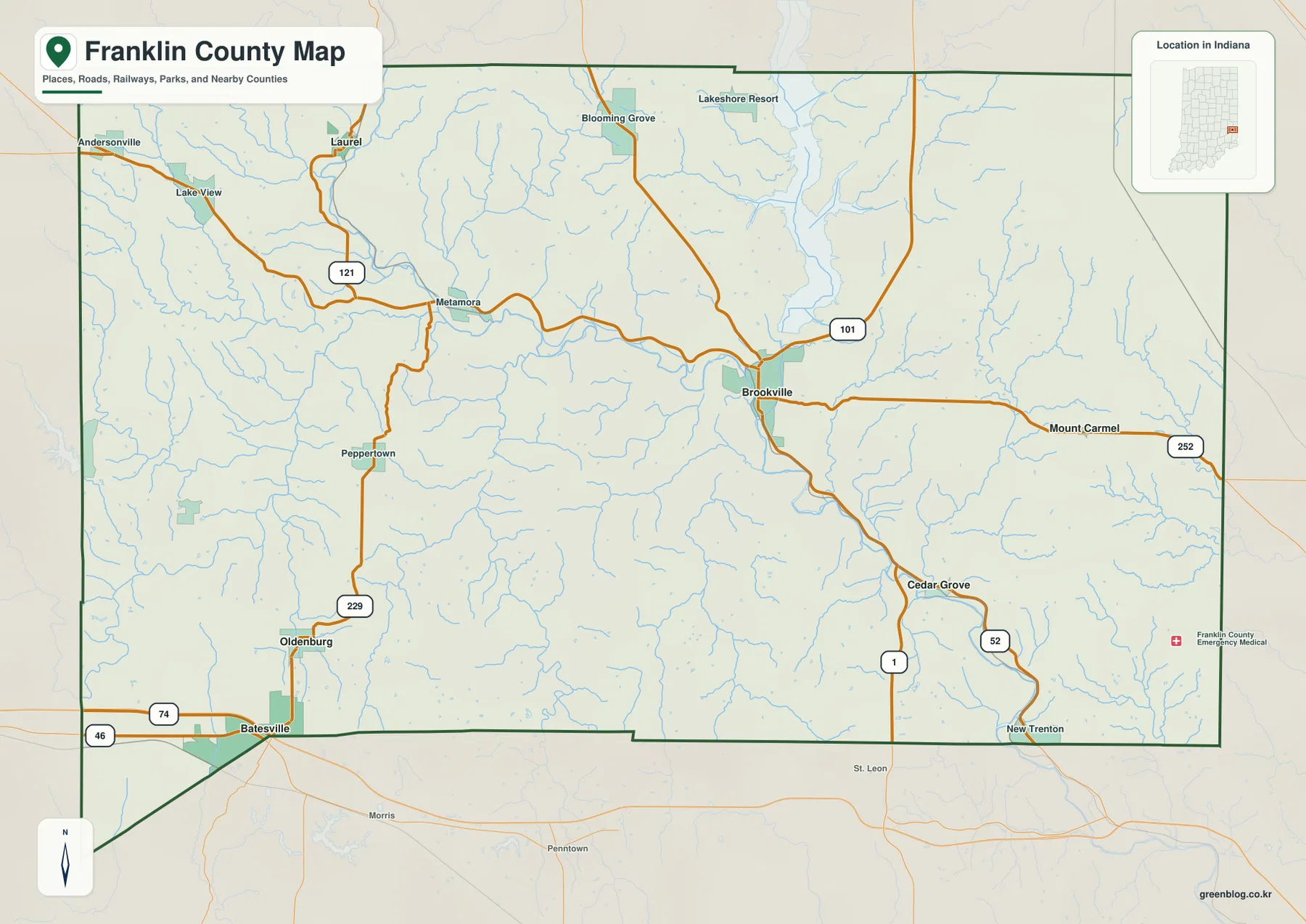
The general map also includes smaller labels that disappear from the simplified city view. Andersonville and Lake View are visible in the northwest, Blooming Grove and Lakeshore Resort appear across the north, and places such as Peppertown and New Trenton provide finer reference points farther south. If you are trying to locate a specific community rather than compare only the largest selected settlements, this is the map to start with.
The county boundary itself is worth noticing. Much of the northern and eastern edge is fairly direct, while the southwest corner bends around the Batesville area in a more irregular shape. That matters when a place is close to the edge because a nearby road or label may fall outside Franklin County even when it looks close on the page. For legal boundary work, however, the map should be treated only as a visual county reference; an official boundary dataset should be used for precise decisions.
As a road reference, the map is intentionally selective. It helps explain where major routes and communities lie relative to one another, but it does not show construction closures, turn restrictions, lane conditions, or every local road. A current navigation source should be used for driving. The strength of this view is that it combines roads with place names, county shape, and waterways so the reader can understand the county as a whole before moving to more specialized maps.
The Brookville hub view reduces the county to four direct-distance connections
The city-connection map strips away much of the detail and uses Brookville as a hub. Four other places are emphasized: Laurel to the northwest, Oldenburg to the southwest, Cedar Grove to the southeast, and Mount Carmel to the east. The printed city index shows Brookville at 2,643, Oldenburg at 770, Laurel at 444, Cedar Grove at 252, and Mount Carmel at 60. Those are values printed on the supplied map and should not be treated automatically as the latest census counts.
The distance labels are especially useful. Laurel is shown 11 miles from Brookville, Oldenburg 12 miles, Cedar Grove 6 miles, and Mount Carmel 7 miles. The legend specifies that these are direct distances in miles, meaning straight-line separation rather than road mileage. A driver may travel farther because local roads follow valleys, ridges, and river crossings. This map is therefore best for quick geographic comparison, not turn-by-turn travel planning.
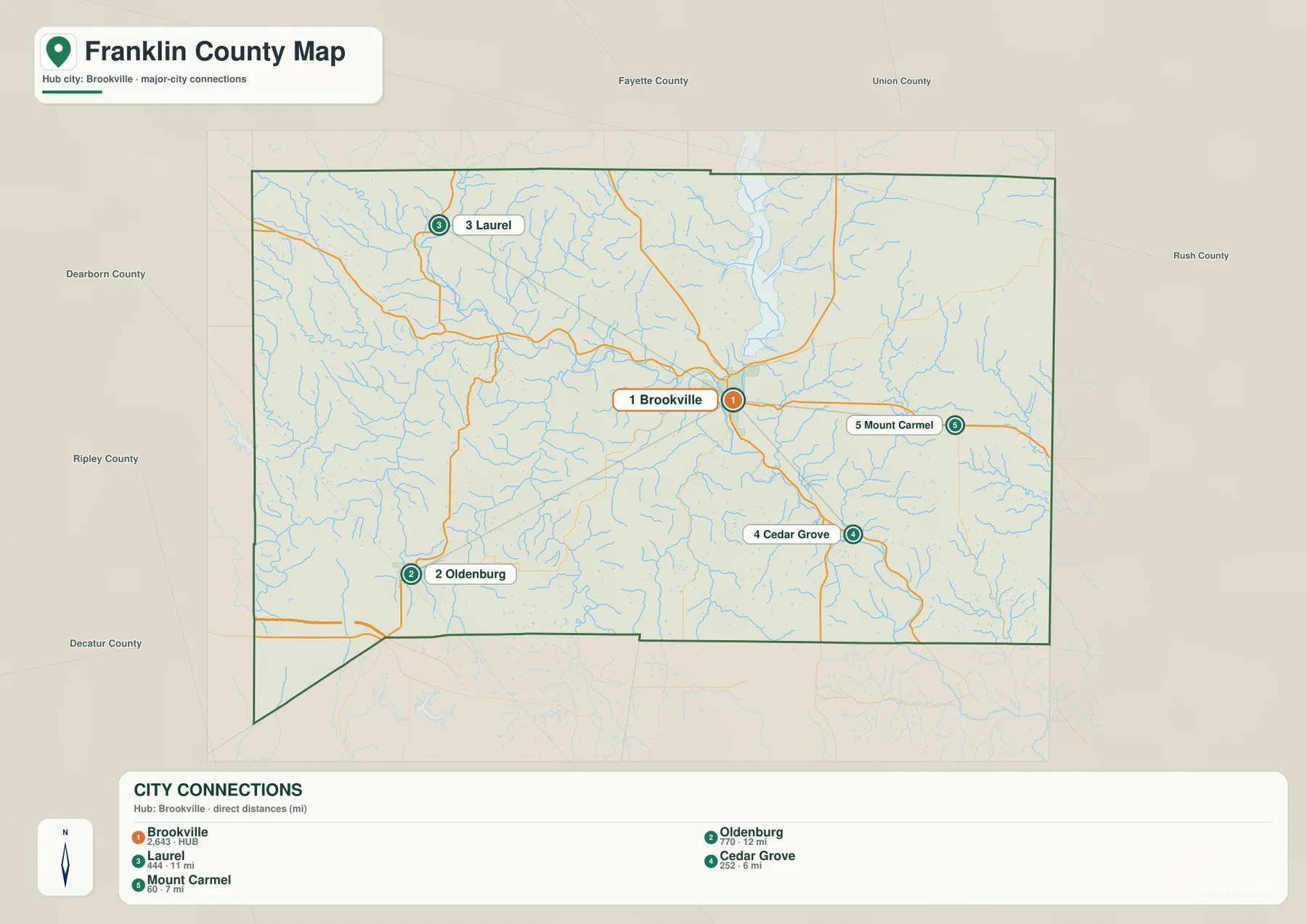
The directional spread of the four places is more informative than the ranking alone. Laurel and Oldenburg lie on opposite sides of the western half of the county, while Cedar Grove and Mount Carmel provide southern and eastern reference points. Brookville sits between them in a way that makes the county’s road and valley structure easier to grasp. If a place such as Metamora or New Trenton is the destination, return to the general map because those locations are not part of this simplified hub selection.
Several surrounding county names appear outside the boundary on this view, including Fayette, Union, Rush, Dearborn, Ripley, and Decatur. Their labels help place Franklin County in the broader eastern Indiana landscape. They should not be read as a substitute for an official adjacency list or boundary survey; the purpose of the city map is to keep the reader focused on Brookville and a handful of selected settlements while retaining enough outside context to understand the county’s position.
A useful way to combine the two settlement maps is to start with the city view and then add detail. First note which direction Laurel, Oldenburg, Cedar Grove, or Mount Carmel lies from Brookville and the approximate straight-line distance. Then switch to the general map to see the numbered roads and smaller communities in between. This keeps the first step simple without losing the local detail needed for a fuller county picture.
Whitewater River forks, the canal, and cedar creeks define the low ground
The terrain-and-water map changes the focus from settlements to drainage. The Whitewater River is prominent in the southeast, while the East Fork Whitewater River enters the Brookville area from the northeast. The Town of Brookville describes the community as being at the junction of the East and West forks, and the map makes that meeting area understandable even without street-level detail. Major water corridors occupy broad, low valleys, while smaller tributaries cut narrow branches into the surrounding hills.
North of Brookville, a large reservoir occupies the East Fork valley. Indiana DNR describes Brookville Reservoir as a 5,260-acre lake in the historic East Fork Whitewater River Valley. On the supplied water map, the reservoir and East Fork form a strong north-south reference leading toward Brookville. This is valuable for understanding the county’s physical layout, but lake levels, boating rules, closures, and recreation conditions should always be checked with DNR because those can change over time.
West of Brookville, the Whitewater Canal label follows another important corridor. The canal is closely associated with Metamora, where the Indiana State Museum operates the Whitewater Canal State Historic Site. That historic context helps distinguish the canal from the natural river system. The terrain map therefore shows two different kinds of water-related features in the same county: natural rivers and creeks that occupy valleys, and a historic transportation canal built to move people and goods through the Whitewater region.
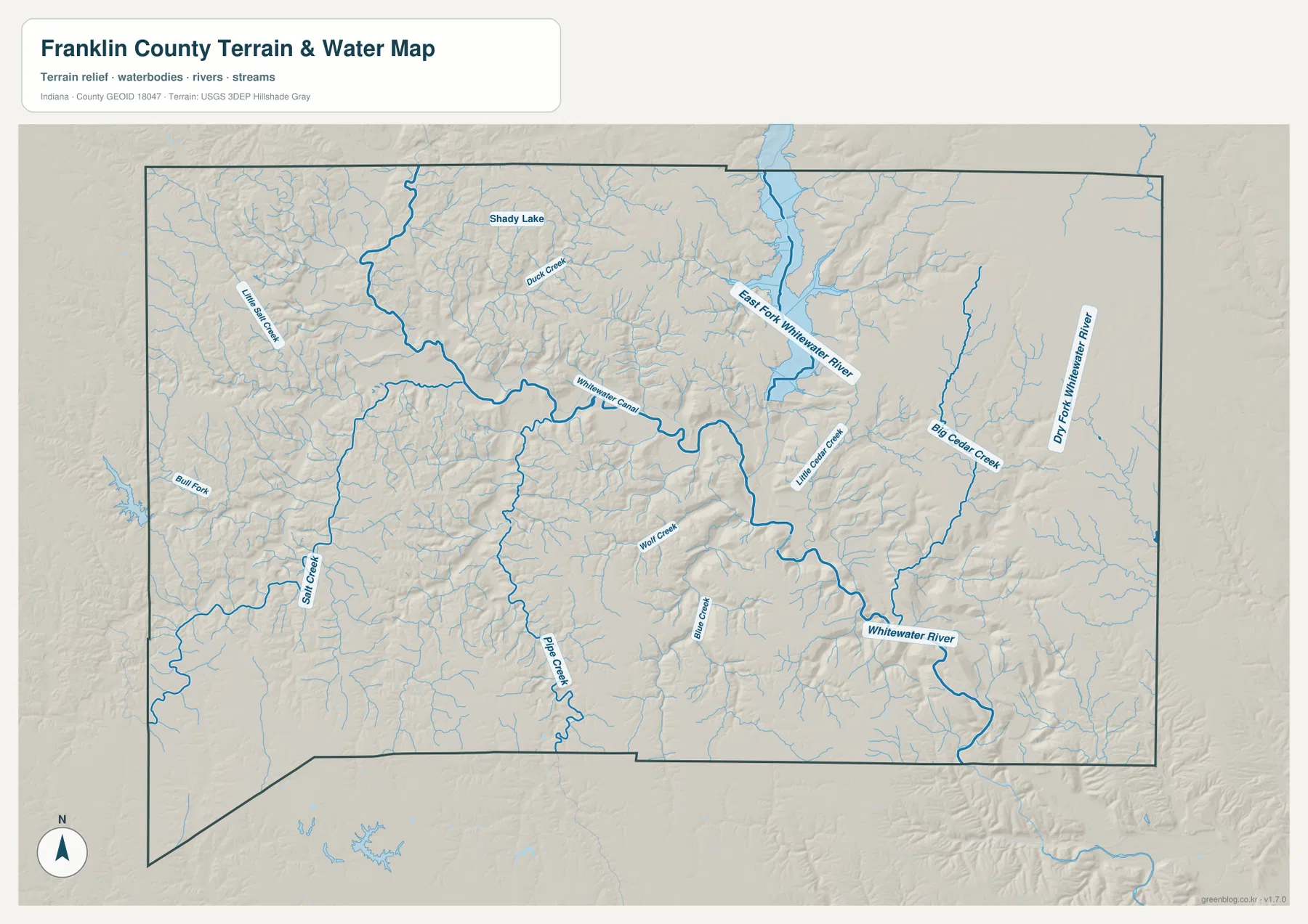
The eastern half contains several named tributaries that are easy to miss on the road map. Dry Fork Whitewater River appears near the eastern side, Big Cedar Creek runs through the east-central area, and Little Cedar Creek is labeled closer to the main Whitewater valley. Their valleys are visible in the shaded terrain and become even clearer on the elevation map. The effect is a branching pattern of low corridors rather than one single broad flat floodplain.
Farther south and west, Salt Creek, Pipe Creek, Blue Creek, and Wolf Creek add more branches. Duck Creek is labeled in the north, Bull Fork appears toward the west, and Shady Lake is marked in the northern part of the county. These names help connect smaller drainage areas to the larger Whitewater system. Readers interested in a particular creek can use this map to find its general position and then compare the same location on the elevation map to see the surrounding relief.
This water map is not a flood-insurance map, navigation chart, parcel boundary map, or legal determination of a stream edge. It shows water features and terrain at county scale. Flood zones, official hydrographic names, water quality, access rights, and channel conditions require current agency information. For the purposes of this page, the map is best used to understand where the main waterways lie and how strongly they shape the county’s valleys.
Elevation from 162 to 326 meters reveals a deeply dissected upland
The elevation map lists an actual county range of 162 to 326 meters and a mean elevation of 278 meters. Lower ground is shown in green, while higher ground shifts through yellow, tan, and brown. The most obvious low corridors follow the Whitewater River and its branches. Instead of one smooth slope across the county, the map shows a network of valleys cutting into higher upland terrain from several directions.
Brookville again provides the clearest example. A broad green corridor arrives from the northeast along the East Fork, while another low valley approaches from the west. After the meeting area, a green band continues toward the southeast along the Whitewater River. The Town of Brookville’s description of higher ground beside a lower river plain fits this pattern well. Even though town labels are absent from the elevation view, the valley junction makes the Brookville area recognizable when compared with the water map.
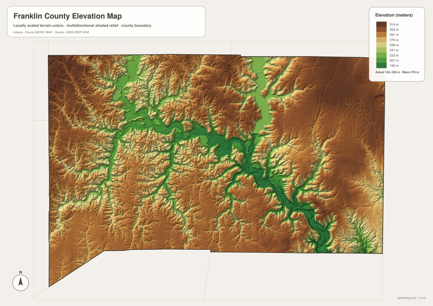
The western and northwestern parts of the county are also broken into repeated ridges and narrow low channels. Tributaries associated with Salt Creek and other streams cut into the uplands, while the Metamora side of the Whitewater valley forms another lower corridor. On the east, broad brown uplands are interrupted by the Dry Fork and Cedar Creek valleys. This makes the county look rugged at map scale even though the absolute elevation range is only a little more than 160 meters from lowest to highest.
The southern half continues the same relationship. Lower channels follow the river and smaller tributaries, and higher ground occupies the areas between them. If you first locate Cedar Grove and New Trenton on the general map and then move to the elevation view, the southeast valley pattern becomes easier to recognize. The same comparison works for Metamora and Oldenburg in the west, where roads and settlements can be related to nearby valleys and ridges.
This elevation surface is generalized for county-wide viewing. It is excellent for seeing relative high and low areas, but it is not survey-grade or engineering-grade elevation. A property corner, bridge deck, road project, drainage design, or construction site requires more precise source data. USGS 3D Elevation Program products or a professional survey should be used when exact elevations are necessary.
Choose the map by question rather than trying to use one view for everything
If the question is where a town or route is located, start with the general county map. It includes Brookville, Metamora, Laurel, Oldenburg, Cedar Grove, Mount Carmel, New Trenton, and many smaller labels along with the main road numbers. If the question is how the selected settlements are positioned around Brookville, the city-connection map is faster because it removes most other detail and adds direct-distance labels.
For river geography, the terrain-and-water map should come first. It names the Whitewater River, East Fork Whitewater River, Whitewater Canal, Big and Little Cedar creeks, Salt Creek, and other waterways. Follow that with the elevation map to see the low valleys those waterways occupy. Brookville is a particularly useful comparison point because the settlement map, river map, and elevation map all show different parts of the same river-junction story.
Metamora is another good example of why the views work better together. The general map provides the town and surrounding roads, while the water map shows the Whitewater Canal and nearby river corridor. The historic-site source explains why the canal remains an important part of Metamora’s identity. For eastern communities such as Mount Carmel or southeastern Cedar Grove, combining the road map with the elevation surface makes the relationship between settlement corridors and nearby valleys easier to see.
For printing, classroom work, local-history notes, or a larger on-screen reference, the original JPG files are more practical than the compressed WebP previews used in the article. Each supplied map is preserved as a separate high-resolution image, so you can choose only the road-and-place view, only the water map, only the elevation map, or compare several side by side. Keeping the subjects separate also prevents labels from becoming overcrowded.
The downloadable images contain the same subjects as the previews but at the original larger dimensions. Use the general map when labels and routes matter, the hub map when selected place-to-place orientation matters, the terrain-and-water map when named streams and the canal matter, and the elevation map when valley and ridge patterns are the focus. The files can be enlarged for easier reading without forcing all four information types into one crowded image.
Higher resolution does not turn these reference maps into legal or survey documents. Property boundaries, zoning, flood regulation, engineering design, exact elevations, and navigation decisions should rely on current authoritative sources. These Franklin County maps are designed to make county geography easy to understand and to provide a convenient downloadable visual reference for ordinary research and presentation needs.
Frequently Asked Questions
Why is Brookville such a useful reference point on the Franklin County maps?
Brookville sits near the meeting area of major Whitewater River branches and is also the hub used on the city-connection map. Roads extend from it toward Metamora, Mount Carmel, Cedar Grove, and other parts of the county. The elevation map shows broad low valleys converging in the same area, so Brookville connects the settlement, road, water, and terrain stories better than any other single labeled place in the supplied set.
Are the 6-, 7-, 11-, and 12-mile city distances driving distances?
No. The city map explicitly labels them as direct distances in miles. It shows Cedar Grove about 6 miles from Brookville, Mount Carmel about 7, Laurel about 11, and Oldenburg about 12 by straight-line separation. Actual road mileage can be longer because routes must follow available roads, river crossings, and the local terrain. Use a current navigation service for driving distance and travel time.
Can the 162–326 meter elevation map be used for surveying or construction?
No. The 162–326 meter range and 278-meter mean describe the generalized elevation surface supplied for county-scale viewing. The map is useful for seeing lower river valleys and higher uplands, but it cannot establish the exact elevation of a property corner, building site, bridge, or road grade. Detailed work should use USGS source elevation data or a professional survey appropriate to the project.
Map File Information
The ZIP contains the original high-resolution JPG versions of the Franklin County general map, city-connection map, terrain-and-water map, and elevation map shown on this page.
- Included Files: 4 high-resolution JPG maps
Related Maps
Sources and References
These official and public sources provide additional context for Franklin County government, Brookville’s river setting, the Whitewater Canal at Metamora, Brookville Lake, hydrography, and elevation. The maps on this page are reader-friendly reference products; current agency source data should take priority for regulatory, engineering, or other high-precision work.
- Franklin County, Indiana official website
- Town of Brookville history
- Whitewater Canal State Historic Site
- Indiana DNR Brookville Lake
- USGS National Hydrography
- USGS 3D Elevation Program
Green Map creates custom-edited map images using open geographic data sources such as geoBoundaries, Natural Earth, OpenStreetMap, and government open data.
These maps are edited visual materials, not raw data files, and are provided for education, documents, presentations, and graphic reference.