You can download the Clay County maps on this page as a high-resolution JPG ZIP for printing or offline use. Clay County stretches much farther north to south than a quick statewide view suggests: Brazil sits along U.S. 40 in the northern section, Knightsville and Harmony are close by, and Clay City lies far to the south in the county’s long lower extension. I-70 crosses the middle-north, while the Eel River forms the most obvious low corridor across the southern half. The maps below connect those roads, communities, waterways and elevation differences in one county-wide view.
The county overview is especially useful because Clay County is not organized around one compact cluster. Brazil anchors the north, Center Point occupies a more isolated position near the middle, and Clay City is separated by a long stretch of rural land. East-west routes cross this elongated shape at several levels, while State Road 59 provides a strong north-south reference. Reading the road map together with the city distribution makes the county’s long outline easier to understand than a simple list of town names.
Water and elevation add another layer. The Eel River bends across the southern interior, Birch Creek runs down the center, and smaller streams such as Otter Creek, Croy’s Creek, Brush Creek and Sixmile Creek divide the surrounding uplands. Lake of the Woods, Dietz Lake and Muir Lake appear as smaller water features. The elevation map reports an actual range of about 155 to 240 meters, with a mean near 185 meters, and shows a broad low zone along the southern river corridor beneath higher northern and eastern ground.
Table of Contents
Brazil anchors the northern road network while Clay City sits far to the south
Start with Brazil when reading the county overview. U.S. 40 crosses the northern part of Clay County and passes through Brazil before continuing toward Knightsville and Harmony to the east. Billtown and Cloverland sit west of Brazil, while Staunton is placed farther southwest. Because several northern communities are close to the U.S. 40 corridor, this part of the county feels more clustered than the long southern extension.
South of Brazil, I-70 cuts across the county from west to east and separates the northern cluster from the broader middle section. State Road 59 continues south toward Clay City, while Route 42 crosses the central-east portion and Route 46 appears farther southeast near Bowling Green. The pattern is useful for orientation: east-west highways intersect a long north-south county, so a destination’s latitude within Clay County matters almost as much as its distance from Brazil.
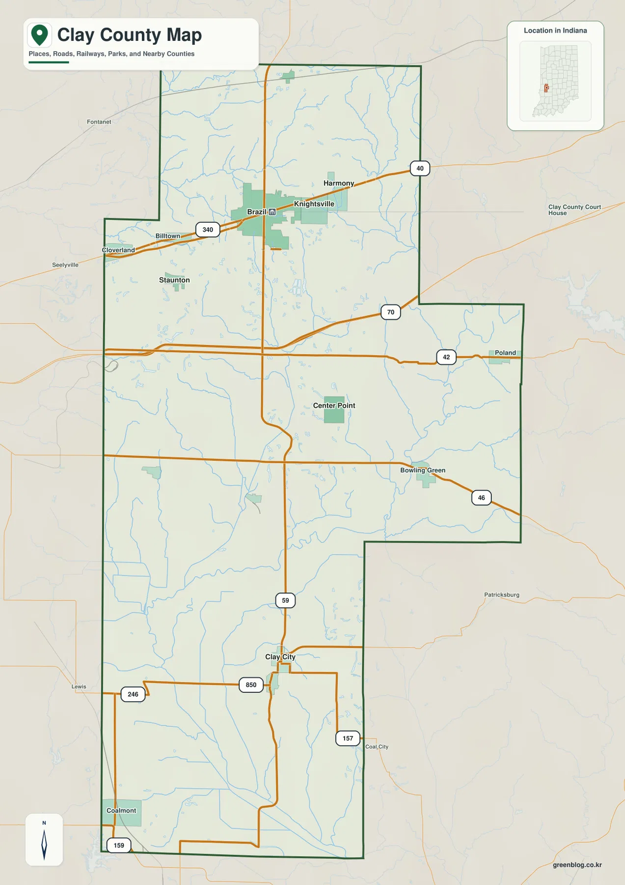
The boundary itself reinforces this geography. The northern portion is relatively broad, the middle changes width as the eastern edge steps inward and outward, and the southern section narrows into a long stem around Clay City and Coalmont. That shape means the county cannot be read as a simple rectangular grid. It is more helpful to think of a northern Brazil area, a central zone around Center Point, and a southern Clay City area linked by the same county boundary but separated by considerable distance.
Six highlighted communities reveal a clear north–south split
The city-distribution map strips away most road detail and emphasizes six places: Brazil, Clay City, Harmony, Knightsville, Center Point and Staunton. Brazil, Knightsville and Harmony form a tight group near the northern edge. Staunton sits to the west of that cluster, Center Point stands alone near the middle, and Clay City is far to the south. The result is a strong visual split between a concentrated north and a much more widely spaced central-southern part of the county.
The index ranks Brazil first and Clay City second among the highlighted places, but the map is most useful for position rather than population comparison. It shows immediately that a trip between Brazil and Harmony stays within the same northern cluster, while travel from Brazil to Clay City crosses a large share of the county. Center Point serves as a useful midpoint reference. These are map relationships, not road-distance measurements; actual driving depends on the route selected and local road connections.
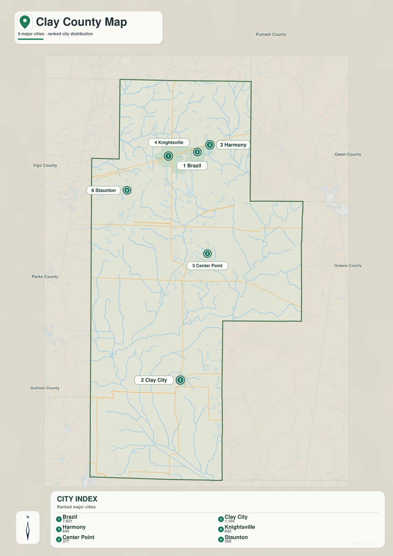
Switching back to the overview explains why the distribution looks this way. Brazil and the smaller northern communities are tied to U.S. 40 and nearby roads, while Clay City sits on the long north-south corridor around State Road 59. Center Point is not part of either tight cluster, so it becomes a natural geographic reference between them. For visitors who do not know Clay County, this two-map sequence is often easier than trying to interpret every road and place label at once.
The Eel River forms the clearest low corridor across the southern half
The terrain-and-water map is dominated by the Eel River in the southern half of the county. It enters from the southwest, bends through the lower interior and continues eastward, with smaller channels and ditches joining it along the way. Conway Ditch and Lafferty Ditch appear south of the main river, while Sixmile Creek approaches from the east. Muir Lake lies near the southern edge, adding another useful point of reference within this broad lowland.
Farther north, Birch Creek runs down the central part of Clay County and connects a large group of smaller tributaries. Brush Creek, Big Slough and Coal Branch occupy the western side, while Otter Creek crosses the northwestern area and Croy’s Creek follows the northeastern side. Lake of the Woods and Dietz Lake are marked within the interior drainage network. The map therefore shows several local water systems rather than one river controlling the entire county.
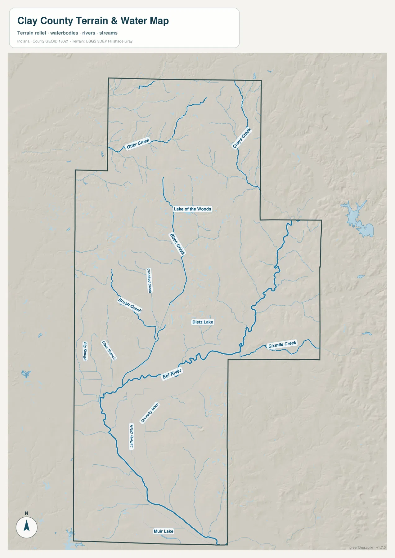
This view is designed for county-scale water and terrain context. It is not a flood-insurance map, a channel-depth chart, a navigation map, or a legal water-boundary product. A low-looking river corridor can help explain the shape of the landscape, but it cannot establish flood risk for a particular property. Property-level flood, drainage, ownership or channel questions require the appropriate official data.
Elevation rises from the Eel River lowlands into northern and eastern uplands
The elevation map reports a county range of about 155 to 240 meters and an average near 185 meters. The broadest dark-green zone occupies the southern and south-central interior, closely matching the Eel River corridor. Other green fingers extend northward along tributary valleys, especially through the central part of the county. This makes the southern half look more open and low compared with the rougher uplands farther north and east.
Higher tan and brown terrain becomes more common in the northern block around and beyond Brazil, and prominent uplands also appear along the eastern side. The western middle contains additional higher patches separated by creek valleys. Clay County therefore does not slope evenly in a single direction. The broad pattern is low along the southern river system and higher toward the north and east, but numerous streams cut narrow lower corridors into the surrounding higher ground.
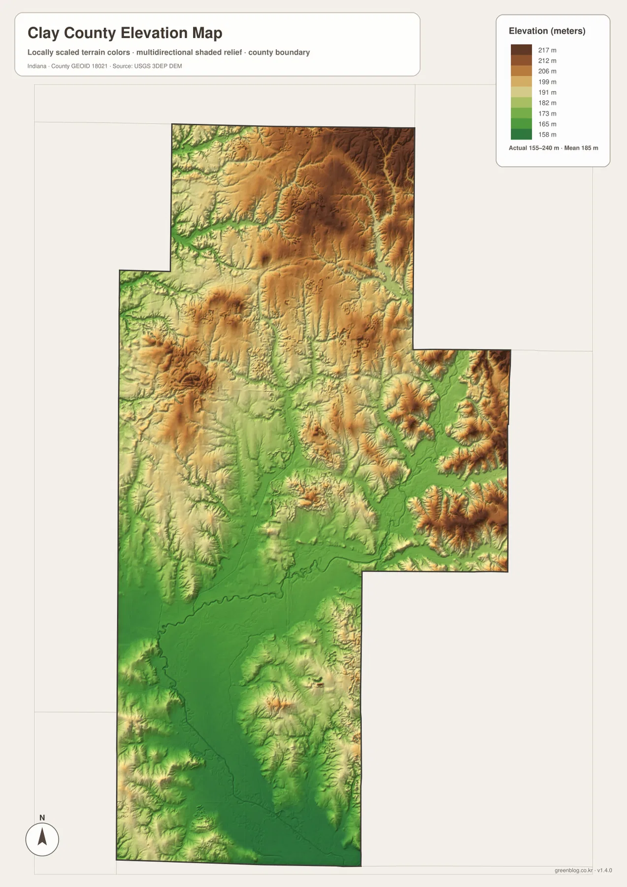
The colors are intended for broad terrain comparison, not survey-grade elevation. Local road cuts, levees, embankments and small property-scale slopes can be generalized at this map scale, and each color represents an elevation range rather than a single exact value. Engineering, construction, drainage and boundary work should use more precise source data. For ordinary map reading, the important relationship is the contrast between the southern river lowland and the higher northern and eastern uplands.
Match the map to the question: roads, settlements, water, or relief
Use the county overview when you need Brazil, Clay City, Center Point, U.S. 40, I-70 or State Road 59 in the same frame. It gives the clearest picture of roads, settlements and county shape. Use the city-distribution view when the main question is how the six highlighted communities are arranged. That simplified screen makes the northern concentration and the large gap to Clay City immediately obvious.
Use the terrain-and-water map for the Eel River, Birch Creek, Otter Creek, Croy’s Creek, Sixmile Creek and the smaller lakes, then compare the same locations on the elevation map. The Eel River valley appears as a broad low band, while creek valleys cut into higher northern and eastern ground. Moving back and forth between those two maps gives a much clearer explanation of Clay County’s relief than either water lines or elevation colors alone.
The WebP maps in the article are reduced for quick browser viewing. For larger labels, printing, or offline reference, the ZIP below contains the original high-resolution JPG versions of all four supplied maps. Each JPG measures 2572 × 3638 pixels.
Use the high-resolution files for orientation, not parcel or engineering decisions
A larger JPG can make labels and terrain colors easier to read, but it does not change the purpose of the map. The overview remains a county-scale road and settlement reference, the city view remains a simplified distribution graphic, and the water and elevation maps remain broad geographic summaries. They work well for understanding how Brazil, Center Point, Clay City, the Eel River and the northern uplands fit together, not for establishing legal property lines or site-level conditions.
The official Clay County site and the City of Brazil site provide local administrative and place context, while Census and USGS resources support boundary, hydrography and elevation reference data. Parcel ownership, official flood determinations, site drainage and construction-grade elevation require the relevant local office, federal program or professional survey. For general orientation and downloadable county imagery, the four supplied maps are most useful when treated as complementary views of the same landscape.
Frequently Asked Questions
Why are Brazil and Clay City so far apart on the map?
Clay County has a long north-south shape. Brazil is in the broad northern section along U.S. 40, while Clay City is near the bottom of the long southern extension. Center Point sits between the two and works as a useful middle reference. State Road 59 is one of the clearest north-south road guides connecting the two parts.
Which map is best for locating the Eel River and Birch Creek?
The terrain-and-water map is the clearest choice. The Eel River is the large curving waterway across the southern half, while Birch Creek runs through the central interior. Checking those same lines on the elevation map shows how each waterway occupies lower ground within the surrounding terrain.
Are Lake of the Woods, Dietz Lake and Muir Lake included in the downloadable maps?
Yes. The downloadable terrain-and-water JPG is the high-resolution version of the map shown on this page, so those named lakes and the mapped creeks are included. The larger JPG is the better choice when you need to enlarge small water labels that are harder to read in the reduced WebP preview.
Map File Information
Download the Clay County maps shown on this page as a high-resolution JPG set. The archive is useful for enlarging road and water labels, comparing the Eel River lowlands with the northern uplands, or keeping printable copies offline.
- Printable Size: 2572 × 3638px each
- File Type: ZIP containing 4 JPG files
Related Maps
Sources and references
- Clay County, Indiana official site — county administration and local information
- City of Brazil official visitor information — local landmarks and place context in Brazil
- U.S. Census Bureau TIGER/Line Shapefiles — county boundaries, roads and place data
- USGS National Hydrography — rivers, creeks and water-network data
- USGS 3D Elevation Program — elevation and terrain data
Green Map creates custom-edited map images using open geographic data sources such as geoBoundaries, Natural Earth, OpenStreetMap, and government open data.
These maps are edited visual materials, not raw data files, and are provided for education, documents, presentations, and graphic reference.