Pulaski County sits at the southern end of Illinois with a shape that widens across the north and narrows sharply toward Mound City at the bottom. Its communities are not gathered around one central place. Mounds and Mound City form a close southern pair, Ullin lies well to the northwest, Karnak anchors the northeast, and smaller reference points such as Olmsted, Pulaski, and New Grand Chain fill the space between them. The county is also defined by water: the Cache River crosses the northern section, the Ohio River follows the eastern and southeastern edge, and a dense network of creeks, sloughs, and bayous occupies the interior. This page connects those features across the supplied maps and provides the matching high-resolution JPG files in a downloadable ZIP.
A useful way to orient yourself is to start with Mounds and Mound City in the south, then trace the numbered roads north and northeast. Routes 51 and 57 rise from the southern section, Route 37 passes Olmsted and New Grand Chain on the way toward Karnak, and Route 169 provides an east-west reference at Karnak. The physical landscape adds another layer. Cache River, Briar Creek, Boar Creek, Hodges Bayou, and Hess Bayou occupy broad or narrow low corridors, while the elevation map shows an actual range of about 89 to 157 meters and a mean near 110 meters. Much of the county is low, but strong ridges in the south-central interior and smaller uplands elsewhere break up the otherwise green lowland surface.
Table of Contents
Roads and County Shape from Mounds and Mound City North
The general county map makes the southern arrangement especially easy to recognize. Mounds sits slightly inland and northwest of Mound City, while Mound City occupies the narrow tip where the county bends toward the broad river corridor. Routes 51 and 57 are the clearest road references in this area, running north from the cluster of southern communities. A separate route angles northeast from the lower county through Olmsted and continues toward New Grand Chain and Karnak. Following these roads from the bottom upward turns an irregular outline into a set of simple geographic steps.
The northern half is wider and the named places are farther apart. Ullin appears in the northwest interior, Karnak is near the northeastern extension, and Pulaski is west of center. New Grand Chain lies between the southern and northeastern groups along the Route 37 corridor. This distribution matters because the county does not have one dominant central cluster on the supplied map. Instead, the reader moves between a southern group around Mounds and Mound City, western and northwestern places around Pulaski and Ullin, and an eastern sequence that leads through Olmsted and New Grand Chain to Karnak.
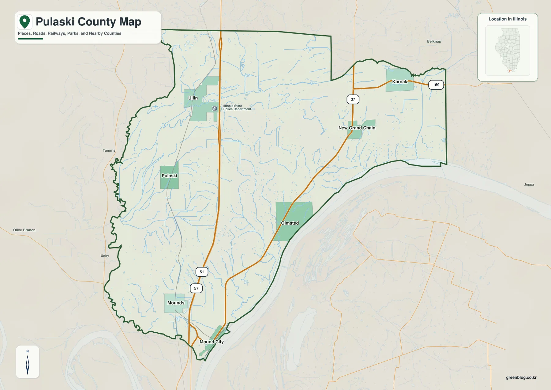
Route 37 is particularly useful for tying the eastern half together. It approaches Olmsted, continues northeast past New Grand Chain, and reaches the Karnak area, where Route 169 creates a clear east-west reference near the county’s northeastern edge. Routes 51 and 57, by contrast, are more helpful for locating Mounds and Mound City and then following the interior northward. These lines make the settlement pattern easier to remember, but the map is not a live traffic product. It does not show current closures, construction, travel times, or road conditions.
The county boundary changes character from one side to another. The northern edge is broad, the northeast projects outward around the Karnak area, and the southern end narrows toward Mound City. The eastern and southeastern side curves along the major river corridor instead of following a simple straight line. Recognizing that outline helps prevent confusion with nearby places shown outside the boundary. The map is useful for general orientation and road relationships, but parcel ownership, legal boundary work, and site-specific property questions require the appropriate official records.
Six Ranked Communities Spread Between the South and Northern Edges
The ranked community map simplifies Pulaski County to six major places. Mounds is listed first and Mound City second, forming the close southern pair. Karnak is third in the northeast, Ullin fourth in the northwest, Olmsted fifth near the southeastern river side, and Pulaski sixth west of center. The value of this map is not the ranking alone. It is the spacing. The southern pair sits close together, while Karnak and Ullin are separated across the width of the northern county and Olmsted occupies a different position along the east.
Mounds and Mound City are easy to confuse because of their similar names, but their positions are distinct. Mounds is farther inland and slightly northwestern, while Mound City sits at the pointed southern end beside the broad river corridor. Olmsted lies northeast of both and acts as a useful step between the southern communities and Karnak. Tracing those three points from south to northeast gives a quick picture of how the eastern side of Pulaski County stretches over a much greater distance than the close spacing of the two southern names might suggest.
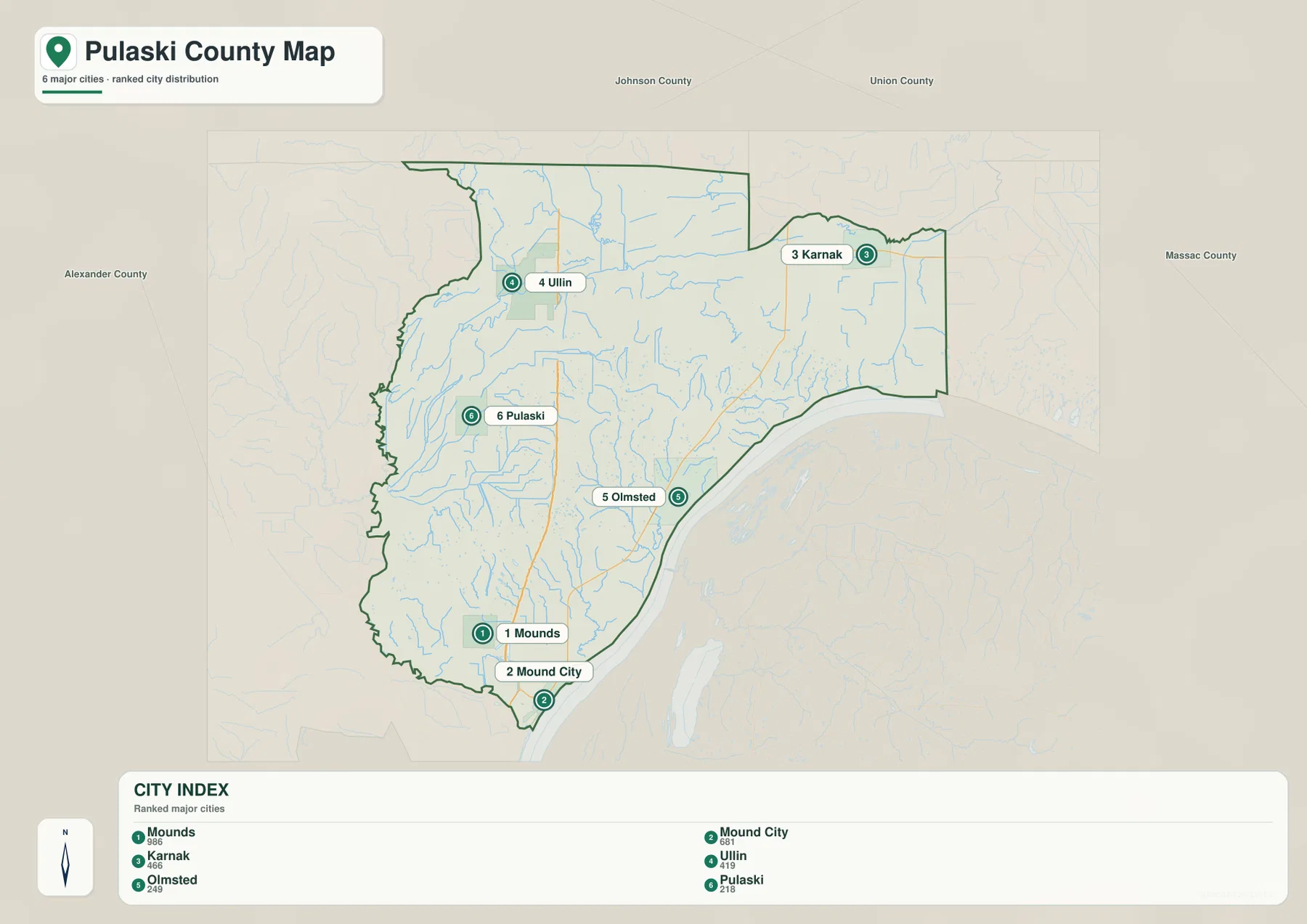
Ullin and Karnak show how broad the county becomes in the north. Ullin is placed toward the northwestern interior, while Karnak is near the northeastern extension. The Cache River runs across the northern section between and around these areas, so the two communities share a broad northern position without occupying identical terrain. Pulaski provides a western central reference farther south, making it easier to divide the county into western, southern, and eastern groups rather than thinking of every place as part of a single compact settlement area.
The ranked map should not be read as a complete list of every named place in the county. New Grand Chain appears on the general map even though it is not one of the six ranked locations, and other names are shown around the county edge for context. Use the community map to establish the large-scale distribution first, then return to the general map when you need roads and additional place names. This two-step approach is especially useful in Pulaski County because the long north-south shape and irregular eastern boundary can make close-looking points feel farther apart once roads and waterways are added.
Cache River, Ohio River, and the Interior Network of Creeks and Bayous
The terrain-and-water map gives Pulaski County a very different appearance from the road map. The Cache River crosses the northern part of the county from west toward east, while the Ohio River forms the broad water edge along the east and southeast. Between them is a dense collection of smaller channels. The map shows that lowland drainage is not confined to one major river. Small creeks, sloughs, and bayous reach through much of the interior and create a network of narrow water corridors between the named communities.
In the northwest, Lence Pond and Mill Creek provide useful labels near the county edge. Farther south and east, Briar Creek becomes one of the clearest named interior streams. Cypress Slough and Pulaski Slough occupy the western side, and Boar Creek extends across the central-western section. These features are especially useful when comparing the map with the location of Pulaski and Mounds. What looks like a broad low surface on a simpler road map is divided by many small channels once the water layer is visible.
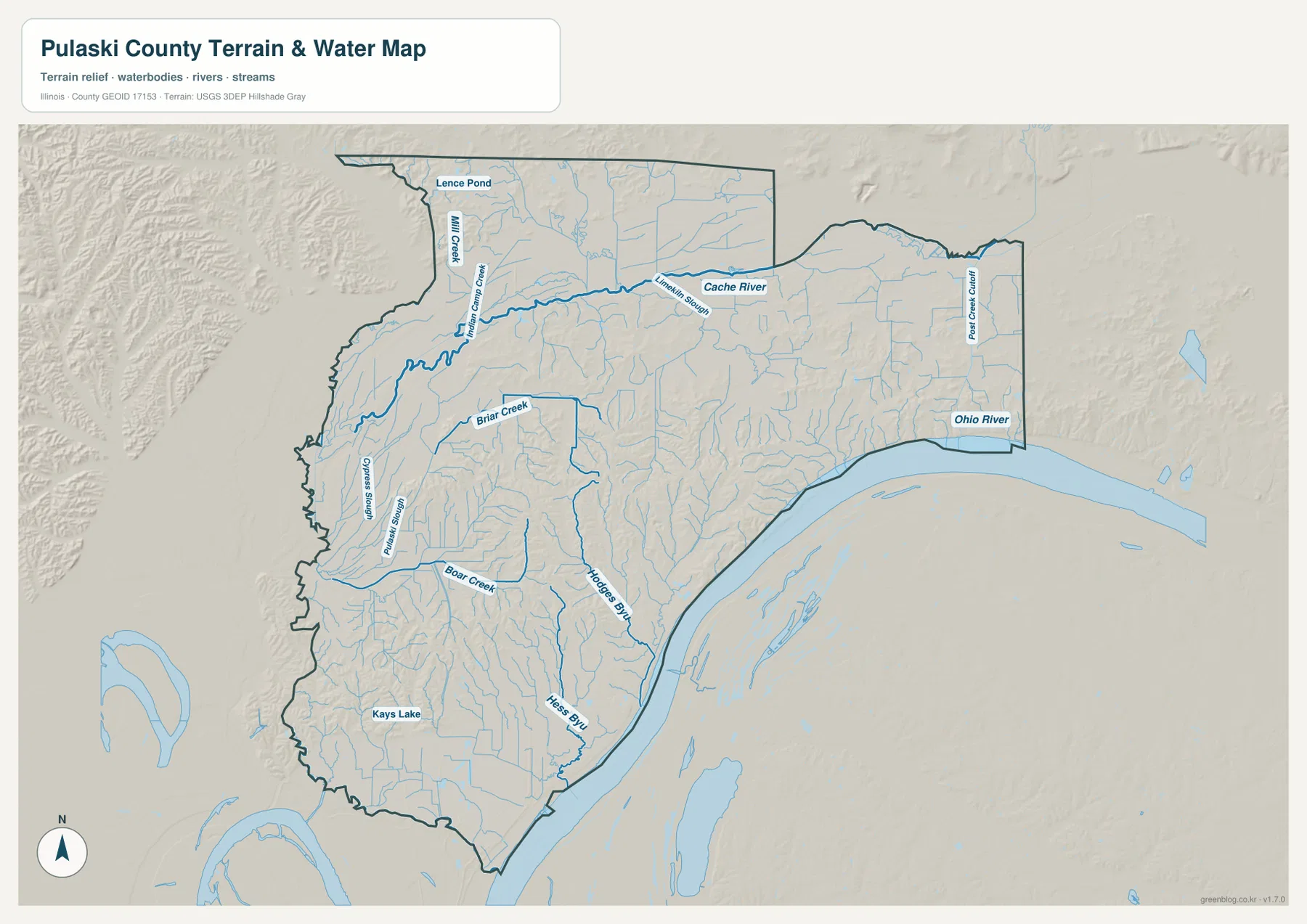
Hodges Bayou and Hess Bayou are the strongest named water references in the central and southeastern interior. Hodges Bayou runs toward the Ohio River through a long low corridor, while Hess Bayou lies farther south. Kays Lake appears in the southwestern portion of the county, giving the lower western side a distinct water landmark. Post Creek Chute is labeled near the eastern side close to the Ohio River. Taken together, these features divide the county into recognizable water areas: Cache River across the north, creek and slough country in the west, bayou corridors in the center and southeast, and the much broader Ohio River along the edge.
This is a reference map for water locations and terrain relationships, not a flood, navigation, wetland-regulation, or parcel product. A labeled creek or bayou does not by itself establish flood risk, water quality, channel depth, or a legal management boundary. Its best use here is geographic: compare where the water features sit relative to Mounds, Pulaski, Olmsted, Karnak, and the county boundary. Then move to the elevation map to see which water corridors occupy broad low ground and which cut through higher ridges.
An 89–157 Meter Landscape with Lowlands and South-Central Ridges
The elevation map lists an actual Pulaski County range of about 89 to 157 meters and a mean near 110 meters. Those numbers describe a generally low county, but the shaded surface is far from uniform. Broad green areas cover much of the north-central and western interior and continue toward the narrow southern end. In contrast, a dense group of tan and brown ridges occupies the south-central interior. Smaller patches of higher relief also appear in the northwest and across parts of the eastern half.
The strongest terrain change is in the south-central section between the low western interior and the Ohio River side. Closely spaced ridges rise above narrow green valleys, creating a textured surface unlike the broad green lowlands farther north and west. Comparing this area with the water map helps explain the pattern. Hodges Bayou and numerous smaller tributaries occupy lower corridors between the ridges, so the water network and the relief are closely connected even though the maps emphasize different features.
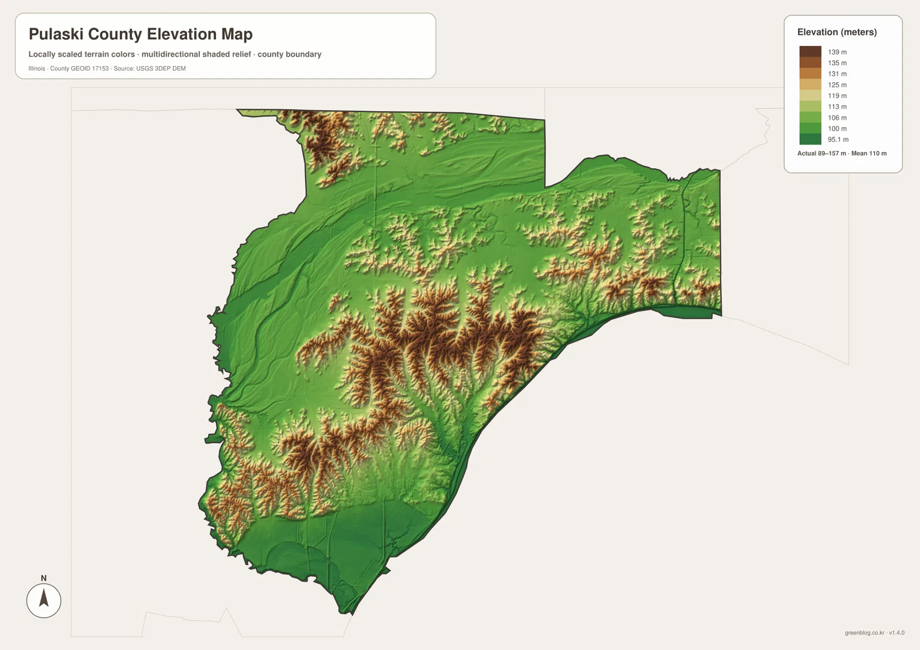
The northwest corner contains another small block of higher terrain, while the eastern half mixes green low corridors with shorter tan ridges. Karnak and New Grand Chain therefore sit in a part of the county that is not simply flat, even though the overall mean elevation is low. The western central area around Pulaski and the broad northern lowlands are greener and less continuously ridged. The narrow southern tip near Mound City is also predominantly low, providing a strong contrast with the higher interior just to the north.
The elevation surface is intended for county-scale comparison, not survey or engineering measurement. It is useful for seeing where uplands and lowlands are concentrated, understanding why waterways occupy certain corridors, and comparing the terrain around different communities. It should not be used to set a building elevation, determine a parcel’s exact slope, or make a site-specific drainage decision. In Pulaski County, the key lesson is that a low average elevation can still contain substantial local relief, especially where the south-central ridges rise above nearby creek and bayou valleys.
Which Pulaski County Map Should You Use First?
For a first look at the county, the road-and-boundary map is the most efficient starting point. It shows how Mounds and Mound City relate to Routes 51 and 57, how Route 37 leads through Olmsted and New Grand Chain toward Karnak, and how the county changes from a broad northern shape to a narrow southern tip. If your question is primarily about where the main communities are rather than how to travel between them, the ranked community map removes much of the road detail and makes the spacing between the six places easier to compare.
Switch to the water map when the Cache River, Ohio River, Briar Creek, Boar Creek, Hodges Bayou, Hess Bayou, or Kays Lake becomes the main question. The water layer reveals low corridors that are nearly invisible on the road view. The elevation map then adds the vertical dimension: broad green lowlands, higher south-central ridges, and smaller uplands elsewhere. Using those two maps together is especially helpful when a stream appears to bend or when a community lies close to both flat ground and nearby ridges.
Mound City is a good example of how the maps complement one another. The general map places it at the narrow southern end beside the main roads, while the community map shows its close relationship to Mounds. The water map places that southern tip beside the broad Ohio River corridor, and the elevation map shows predominantly low terrain around the end of the county. Karnak provides a different comparison in the northeast, where Routes 37 and 169, the Cache River region, and a mixture of low ground and nearby ridges all come together.
The WebP images on this page are sized for convenient on-screen reading. The ZIP below contains the matching high-resolution JPG files for printing and closer inspection of labels and small waterways. These maps are intended for general geographic reference and explanation. Current traffic conditions, legal parcel boundaries, flood determinations, wetland regulations, and survey-grade elevation questions should be checked through the appropriate specialized official sources rather than inferred from these reference layers.
Frequently Asked Questions
How can I tell Mounds and Mound City apart on the map?
Both are in the southern part of the county, but Mounds is farther inland and slightly northwest, while Mound City occupies the narrow southern tip beside the Ohio River corridor. The ranked community map lists Mounds first and Mound City second, making the pair easy to compare. On the general map, Routes 51 and 57 provide an additional road reference for separating the two locations.
Which map is best for following the Cache River and interior waterways?
The terrain-and-water map is the best choice because it shows the Cache River across the north together with the Ohio River, Briar Creek, Boar Creek, Hodges Bayou, Hess Bayou, Kays Lake, and many smaller channels. Comparing it with the elevation map also shows which waterways occupy broad low ground and which pass through narrower valleys. It is a general reference layer, not a flood or navigation map.
What files are included in the Pulaski County download ZIP?
The ZIP contains four 3638 × 2572 pixel JPG files matching the maps on this page: the county road-and-boundary map, the six-place ranked community map, the terrain-and-water map, and the elevation map with an actual range of about 89–157 meters. The larger JPGs are useful when you want to print the maps or inspect small labels more closely than on the page-sized WebP images.
Map File Information
The archive includes the Pulaski County road-and-boundary map, ranked community map, terrain-and-water map, and elevation map as high-resolution JPG files.
- Printable Size: 3638 × 2572 pixels each
- File Type: ZIP containing 4 JPG files
Related Maps
Sources and References
- U.S. Census Bureau TIGER/Line Shapefiles – reference for county boundaries, roads, and place geography
- USGS National Hydrography – reference for rivers, creeks, sloughs, and other mapped water features
- USGS 3D Elevation Program – reference for elevation and terrain relief
Green Map creates custom-edited map images using open geographic data sources such as geoBoundaries, Natural Earth, OpenStreetMap, and government open data.
These maps are edited visual materials, not raw data files, and are provided for education, documents, presentations, and graphic reference.