Pope County has one of the more distinctive outlines in the supplied Illinois county map set. Its northern half is broad, the county narrows as it extends south, and the eastern side follows a long curving river edge. Inside that boundary, short creeks branch through a strongly ridged landscape rather than crossing one broad, level plain. Golconda appears near the eastern river side, while Eddyville is well to the north in the interior. The maps on this page make those differences easy to compare, and the matching high-resolution JPG files are available together in the download archive below.
A useful way into the county is to follow the numbered roads first: Routes 34, 145, 146, and 147 lead to Eddyville, Herod, New Liberty, and the river-facing part of the county near Golconda. From those reference points, Lake Glendale and the dense network of Little Saline River, Lusk Creek, Bay Creek, and smaller tributaries explain why the interior is broken into so many short valleys. The elevation legend adds the final piece, with an actual range of about 92 to 234 meters and a mean near 154 meters. High ground dominates much of the north, while lower terrain follows the eastern river corridor and several interior creek valleys.
Table of Contents
A Long County Outline from Herod to the Southern River Bend
The easiest way to orient yourself on the general map is to begin in the wide northern part of the county. Eddyville sits inland near the center of that northern half, with Route 147 entering from the west and continuing toward the community. Herod appears farther northeast, close to Route 34 and the county edge. These two places establish the upper part of Pope County before the boundary begins to narrow and bend southward. Near the eastern side, the Pope County Courthouse symbol provides another useful reference close to the river-facing portion of the boundary.
Roads 145 and 146 become more useful as the eye moves south. Route 146 crosses the county from west to east through the lower-middle section and heads toward the eastern boundary, while Route 145 runs through the western interior and meets the east-west route. The road arrangement makes the county’s changing width obvious: the broad north allows several routes to spread apart, but the southern extension compresses roads and waterways into a much narrower shape. New Liberty is labeled in this southern section, giving the long tail of the county a named location rather than leaving it as an empty outline.
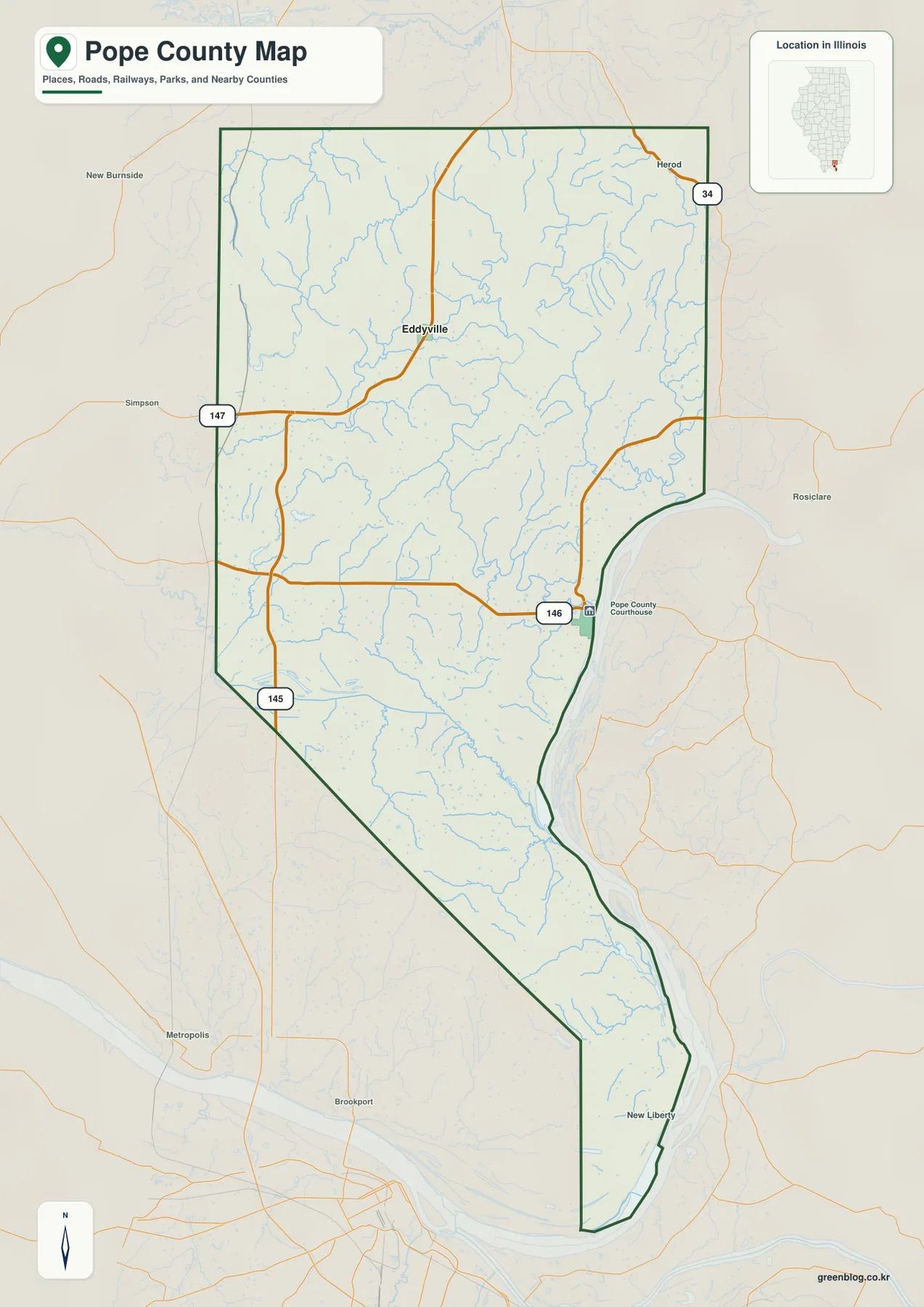
The boundary itself deserves attention because it is not a simple rectangle. Long straight segments define parts of the north and west, but the eastern edge curves around a broad river channel and the middle of the county pinches inward before stretching south. That irregular shape helps explain why a place can look close on a statewide map yet require a very different local route within Pope County. The background also labels nearby places such as New Burnside, Simpson, Rosiclare, Metropolis, and Brookport, which are useful for distinguishing the county interior from the surrounding area.
This map is best used for general orientation: county boundary, named places, and the main road framework. It is not a live traffic map and does not show current closures or construction. It also should not be treated as a parcel or legal-survey product. Its strongest value is that it lets a reader establish where Eddyville, Herod, New Liberty, and the major routes sit before adding the more complicated creek and elevation information from the other maps. In Pope County, that sequence is especially helpful because the physical terrain is much more intricate than the basic road view suggests.
Two Ranked Communities, Far Apart: Golconda and Eddyville
The community map is intentionally spare. It ranks Golconda first and Eddyville second, then removes much of the road detail so their relative positions become the main story. Golconda lies close to the eastern river edge around the middle of the county, while Eddyville is well north and inland. They do not form a continuous urban strip. Instead, the two points are separated by a broad expanse of creeks, ridges, and winding local terrain. That separation is a defining feature of the supplied Pope County maps and is more useful than simply knowing which community is ranked higher.
Golconda works well as the reference point for the curved eastern boundary. Its position makes the large river corridor immediately relevant, and the nearby county-boundary bend is easy to recognize. Eddyville is a better reference for the upland interior. From there, the county spreads toward Herod in the northeast and toward the western boundary, while the terrain-and-water map shows numerous tributaries breaking the land into short ridges and valleys. Switching between these two reference points prevents the long county from being treated as if every part shared the same physical setting.
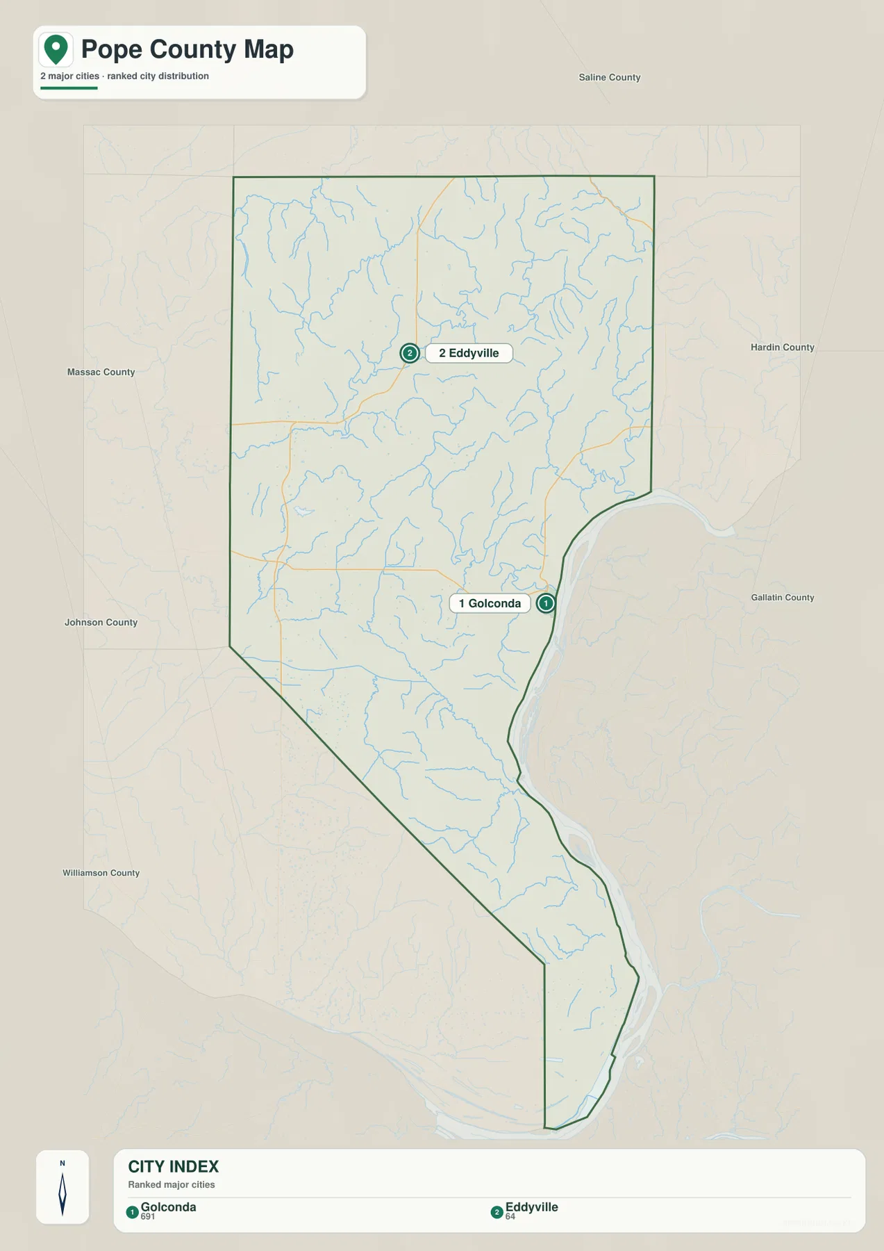
Neighboring county labels add another layer of orientation. Saline County is shown to the north, Hardin and Gallatin counties to the east, and Massac and Johnson counties on the western side of the map. Those surrounding names make the irregular Pope County outline easier to remember. The northern block looks comparatively wide, the central-eastern boundary bends inward around the river, and the south becomes much narrower. A community map with only two ranked places might seem simple at first, but the surrounding labels and boundary shape explain why Golconda and Eddyville represent two quite different parts of the county.
The map should not be read as a complete list of every settlement. The general map also labels Herod and New Liberty, and additional place names appear beyond the county line. The ranked community layer is better understood as a quick comparison tool. Start with Golconda and Eddyville, then return to the general map to add roads and smaller named locations. This two-step approach keeps the large-scale pattern clear before the page moves into the much denser water network and terrain.
Creek Country around Lake Glendale and Lusk Creek
The terrain-and-water map is where Pope County becomes visually complex. Little Saline River appears along the northwest, with Hayes Creek and Sugar Creek extending through the western interior. Lake Glendale is labeled beside Sugar Creek and provides an easy landmark in a part of the county otherwise filled with many similarly sized tributaries. In the center, Lusk Creek is one of the most prominent named waterways. Farther northeast, Little Lusk Creek, Simmons Creek, and Little Grand Pierre Creek occupy separate valleys, while a dense web of unnamed smaller branches fills the ridges between them.
The southern half has a different set of named streams. Bay Creek and Bay Creek Ditch cross the lower-middle part of the county toward the eastern river corridor. Farther south, Barnes Creek and Dog Creek appear in the narrowing section, with additional short tributaries shown on the western side. These waterways are not arranged as one simple north-to-south drainage line. They occupy many short valleys that converge toward larger channels, which is why the shaded relief looks deeply cut even where no single large inland river dominates the map.
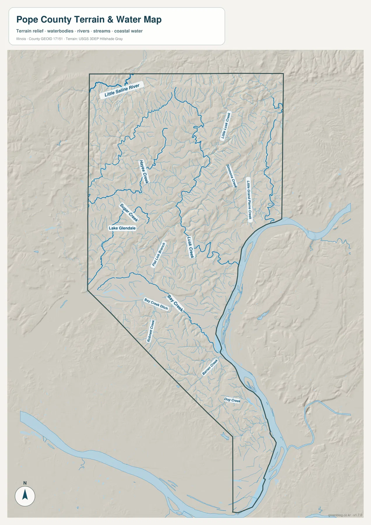
The broad water channel on the eastern side contrasts sharply with the inland creeks. Along the eastern boundary, the water is wide and the county line bends beside it for a long distance. Inside the county, most named streams are narrow and branch repeatedly through the hills. That difference helps distinguish Golconda’s setting from Eddyville’s. Golconda is tied closely to the large eastern river corridor, while Eddyville sits within the tributary-rich interior. On the general map the two places are simply points; on the water map they belong to very different physical environments.
This map is intended for geographic reference, not flood determination, navigation, water-quality analysis, or legal water boundaries. A creek shown on the map confirms its general mapped location and relationship to the terrain, but it does not indicate current water depth, channel condition, or the exact extent of flood-prone land. The most useful way to work with it is to identify a named feature such as Lake Glendale or Lusk Creek, then compare the same area with the elevation map. Low green valleys often align with the waterways, making the connection between drainage and relief much easier to understand.
Relief from 92 to 234 Meters: Northern High Ground and Low River Corridors
The elevation map lists an actual county range of about 92 to 234 meters and a mean near 154 meters. Those numbers are useful, but the color pattern explains the terrain more clearly. Much of the northern section is tan to brown, showing extensive higher ground cut by narrow green valleys. A particularly strong ridge system runs across the upper part of the county, and another elongated area of higher relief stands out farther east. The high ground is not one smooth plateau. It is divided into many short ridges by the same tributaries that appear on the water map.
Lower terrain is concentrated along the large eastern river corridor and through several interior valleys. Green areas broaden near the river and in parts of the central and southern county, while narrow green fingers reach into the tan uplands along creeks. This pattern is important because it distinguishes two different kinds of low terrain: broad river-edge lowlands and narrow inland valleys. Looking at the water map first helps explain which is which. Lusk Creek and Bay Creek occupy long interior lows, while the eastern boundary follows a much wider low corridor.
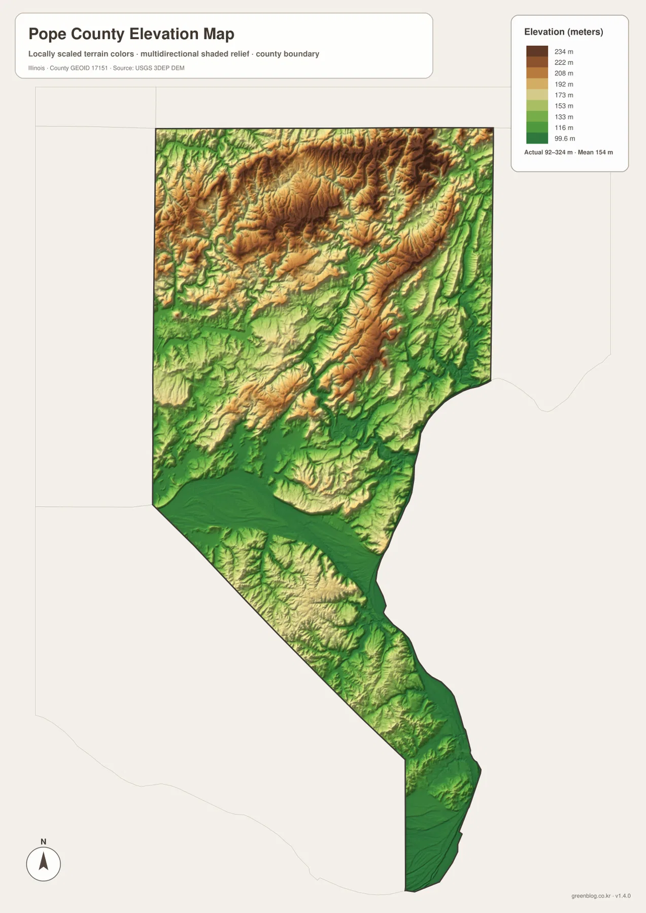
Eddyville’s inland position makes more sense on this map. The community is surrounded by a strongly dissected upland where higher ridges and lower creek valleys alternate over short distances. Golconda, by comparison, is near the lower eastern river corridor. Herod is also in the northern hill country, where the shaded relief shows closely spaced ridges and drainage lines. Farther south, the county remains uneven, but the narrow shape and larger areas of green make the contrast with the high northern block especially noticeable.
The elevation surface is a general regional representation rather than survey-grade measurement. It is excellent for recognizing high and low areas, comparing the northern uplands with river corridors, and seeing how creek valleys cut through the hills. It should not be used to establish an exact building elevation, property slope, engineering grade, or other site-specific measurement. For a visitor trying to understand Pope County, however, the relief map is one of the most informative layers because it explains why the road and water maps contain so many bends and short valleys.
Choosing the Pope County Map That Fits the Question
Golconda is a useful example of how the maps work together. On the ranked community map it is the first-listed major place and sits against the eastern side. The general map adds the county boundary and road framework, including Route 146 approaching the river-facing part of the county. The water map shows that the location belongs to a broad river corridor rather than one of the narrow inland creek valleys. The elevation map then confirms that this eastern edge is generally lower than the high northern interior. Following one place through the maps produces a much richer picture than treating each layer as an isolated graphic.
Eddyville offers the opposite comparison. It is the second-ranked community and lies far north of Golconda. Route 147 provides a clear road reference on the general map, while the terrain-and-water layer places Eddyville among tributary valleys rather than beside the broad river. The elevation map shows substantial high ground around the northern interior. Herod extends the same comparison toward the northeast, and New Liberty helps locate the narrow southern reach of the county. These named points let a reader divide a long, irregular county into understandable sections.
Choose a file by the feature you need rather than by trying to use every layer at once. Routes and county shape are easiest to follow on the road-and-boundary view, while the simplified community view quickly establishes how far apart Golconda and Eddyville are. If the question shifts to Lake Glendale, Lusk Creek, Bay Creek, or the many tributary valleys, the terrain-and-water image supplies the needed detail; the elevation image then shows whether those places lie in lower green corridors or among the higher northern ridges. The WebP images are sized for reading on the page, and the download archive provides the matching larger JPG files for printing and closer inspection.
Combining layers is particularly useful in Pope County because the natural features change over short distances. A road can cross several creek valleys between two named places, and a location that looks close to a river on the general map may sit above a much more uneven interior than expected. The maps provide a strong overview for study, local orientation, and general geographic explanation, but specialist questions still require specialist sources. Current road conditions, parcel boundaries, flood determinations, and engineering elevations should always be checked with the appropriate official records rather than inferred from these reference maps.
Frequently Asked Questions
Should I start with Golconda or Eddyville when orienting myself in Pope County?
Start with Golconda if the eastern river edge and the middle of the county are your main reference, and start with Eddyville if you are looking at the northern interior and Route 147. The ranked community map makes their separation obvious. From there, the general map adds Herod, New Liberty, and the main numbered roads, while the water and elevation maps explain why Golconda’s river-side setting differs so much from the ridged terrain around Eddyville.
What becomes clearer when Lake Glendale and Lusk Creek are compared with the elevation map?
The water map places Lake Glendale beside Sugar Creek and shows Lusk Creek running through the interior among many tributaries. On the elevation map, those waterways correspond to lower green valleys that cut into higher tan and brown ridges. The comparison makes it clear that Pope County’s drainage is closely tied to its rugged relief. The supplied elevation legend gives an actual range of about 92–234 meters and a mean near 154 meters.
What is included in the Pope County download ZIP?
The ZIP contains four 3638 × 2572 pixel JPG files matching the maps used on this page: the county road-and-boundary map, the ranked Golconda–Eddyville community map, the terrain-and-water map with Lake Glendale and named creeks, and the elevation map covering about 92–234 meters. They are suitable for general geographic reference and printing. Legal boundaries, flood determinations, live traffic conditions, and survey-grade elevations require the appropriate official specialist source.
Map File Information
The archive includes the Pope County road-and-boundary map, ranked community map, terrain-and-water map, and elevation map as high-resolution JPG files.
- Printable Size: 3638 × 2572 pixels each
- File Type: ZIP containing 4 JPG files
Related Maps
Sources and References
- U.S. Census Bureau TIGER/Line Shapefiles – reference for county boundaries, roads, and place geography
- USGS National Hydrography – reference for mapped rivers, creeks, and water features
- USGS 3D Elevation Program – reference for the county’s elevation and relief
Green Map creates custom-edited map images using open geographic data sources such as geoBoundaries, Natural Earth, OpenStreetMap, and government open data.
These maps are edited visual materials, not raw data files, and are provided for education, documents, presentations, and graphic reference.