Logan County sits in central Illinois with Lincoln near the middle of the county and several smaller communities spread in different directions around it. Atlanta lies to the northeast, Mount Pulaski to the southeast, Elkhart to the southwest, and Hartsburg and Emden to the north and northwest. That arrangement makes Lincoln a useful reference point for reading the maps, because the main road pattern, the creek network, and the changes in elevation can all be compared from the center outward.
This page includes a county and road map, a ranked city map, a terrain and water map, and an elevation map. You can download the same four maps as high-resolution JPG files in one ZIP from the download box below, while the WebP versions are placed in the article for quick viewing. The maps are especially useful for comparing Lincoln with Atlanta and Mount Pulaski, locating Kickapoo Creek and Sugar Creek, and seeing why the northeast part of the county stands higher than the broad central lowlands.
Table of Contents
Roads radiating from Lincoln across an irregular county boundary
Lincoln is the clearest starting point on the county map. It is near the center of Logan County, where several numbered roads meet or pass close to one another. Route 55 heads northeast toward Atlanta, Route 155 reaches north toward Hartsburg, and Route 10 extends east toward Beason. Roads also continue southeast toward Mount Pulaski and Latham and southwest toward Broadwell and Elkhart. Looking at these routes together shows why Lincoln functions as the easiest geographic anchor for the rest of the county.
The county outline adds another useful layer. Logan County is not a simple rectangle: the northeast boundary steps inward and then extends east again around the Atlanta area, while the southwest and south edges contain additional notches. New Holland and Middletown sit near the western side, and San Jose appears just beyond the northwest boundary. Chestnut and Latham are separated in the southeast, which helps show that the eastern half of the county contains several distinct settlement areas rather than one continuous town corridor.
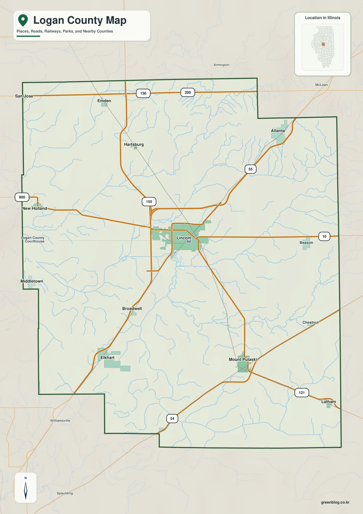
Mount Pulaski stands out in the southern half of the map. From Lincoln, the route toward Mount Pulaski runs southeast through open interior areas before continuing toward Route 121 and Latham. Elkhart lies farther west, while Broadwell sits closer to the Lincoln-to-Elkhart direction. For a reader who wants to understand where towns are located before looking at terrain or waterways, this map is the best first view. It is a geographic reference map rather than turn-by-turn navigation, so current travel planning should still rely on a dedicated road service.
Six ranked cities spread from Atlanta to Mount Pulaski and Elkhart
The city map highlights six places and gives each one a rank. Its index lists Lincoln at 13,281, Atlanta at 1,580, Mount Pulaski at 1,507, Elkhart at 533, Hartsburg at 415, and Emden at 387. The numbers are useful, but the map becomes more informative when they are read together with location. Lincoln occupies the center, Atlanta is clearly separated in the northeast, Mount Pulaski is in the southeast, and Elkhart lies to the southwest. Hartsburg and Emden form smaller northern reference points.
Atlanta and Mount Pulaski are especially helpful for understanding the county’s scale because they sit in opposite diagonal directions from Lincoln. Atlanta is close to the northeastern projection of the county and the Route 55 corridor, while Mount Pulaski is surrounded by the broad southern interior. Elkhart sits on the other side of that southern area, so the three places do not form a tight cluster. Hartsburg and Emden, meanwhile, make it easier to see how the northern communities are separated from both the central city and the southern towns.
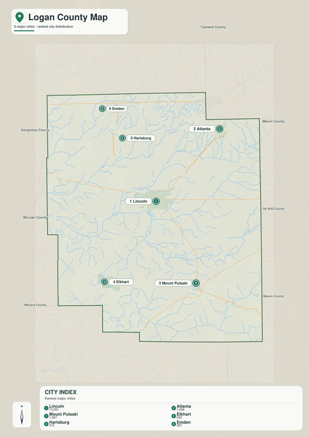
This city view deliberately simplifies the map instead of labeling every settlement. The county map adds places such as Beason, Broadwell, New Holland, Middletown, Chestnut, and Latham, while the ranked map keeps attention on the six largest highlighted communities. Using the two maps together makes it possible to distinguish the major population centers from the smaller places without losing their relative positions.
Kickapoo Creek, Sugar Creek, and a web of smaller branches
The terrain and water map shows a dense drainage network across the northern and central parts of Logan County. West Fork Sugar Creek runs across the northeast, with Sugar Creek and Kickapoo Creek occupying the broad area below it. Prairie Creek is labeled in the northwest, while Deer Creek appears farther east. Near the center, Brainard Branch and Salt Spring Branch add smaller channels around the Lincoln area. Together these waterways show that the county’s apparently open interior is crossed by many shallow valleys and local drainage lines.
The southern half has a different set of names and directions. Elkhart Slough is marked in the west, Lake Fork runs through the south-central area, and Salt Creek follows the eastern side. North Fork and South Fork are labeled closer to the eastern and southern edges, while Pine Lake appears as a small named water body in the southeast. A practical way to read the map is to start with Sugar Creek and Kickapoo Creek in the north, then follow Lake Fork southward and Salt Creek along the east.
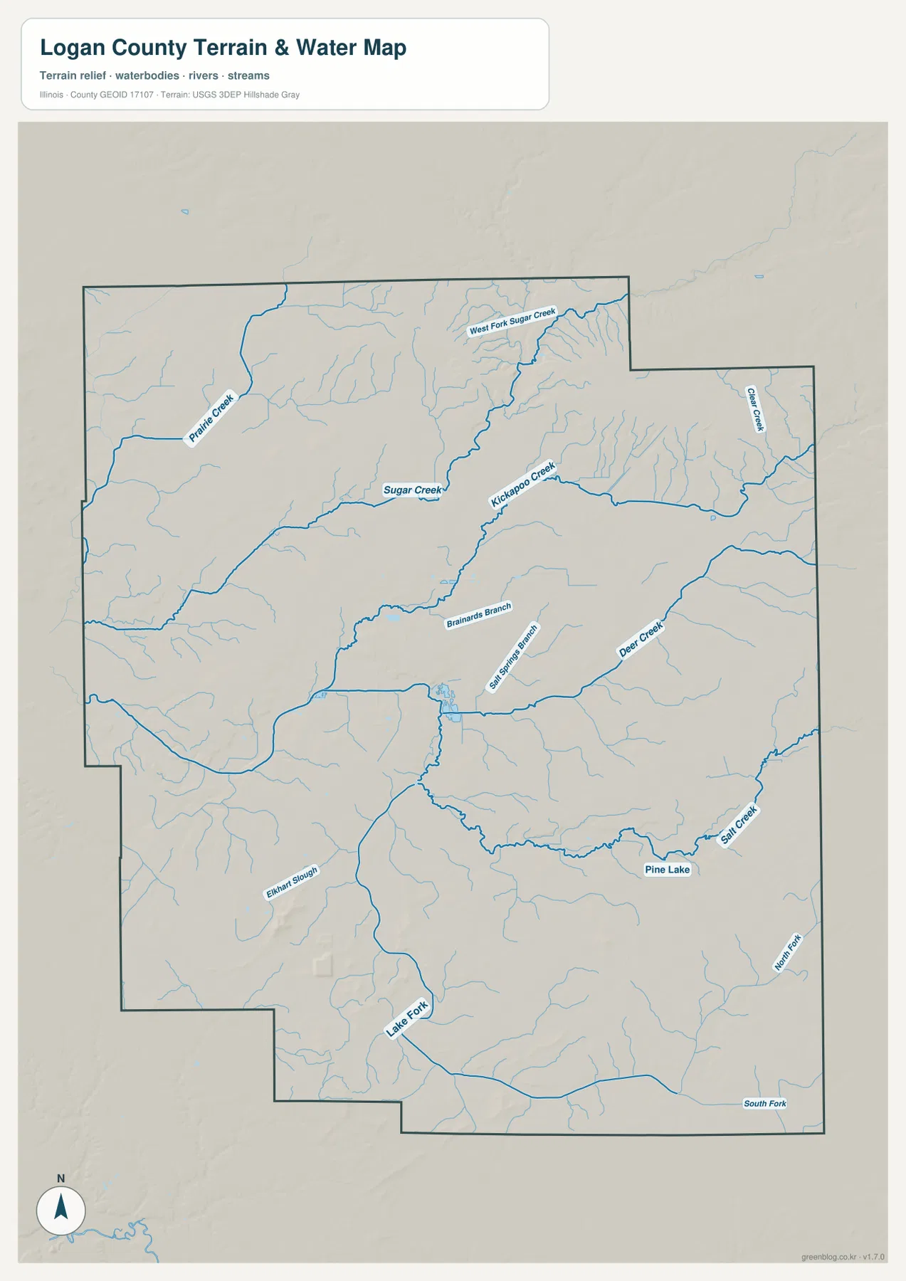
This map is intended for geographic reference, not for flood determination, legal water boundaries, drainage engineering, or navigation. Its value is in showing where named creeks and branches sit relative to the county outline and the surrounding terrain. When it is compared with the elevation map, many of the watercourses line up with lower green corridors, while the higher northeast terrain sits above the main creek valleys.
A 153–233 m landscape with its strongest rise in the northeast
The elevation map reports an actual range of about 153 to 233 meters and a mean elevation of about 182 meters. Logan County is not mountainous, but the color contrast still reveals meaningful differences. The northeast contains the broadest brown and tan high ground, while much of the center and west is shown in greens that represent lower terrain. Stream valleys cut through those lower areas, creating a landscape of broad flats, shallow depressions, and gentle rises rather than steep mountains.
Lincoln sits closer to the broad middle elevations than to the highest ground. The terrain rises more noticeably toward Atlanta and the northeastern edge, where the hillshade also shows stronger relief. The southern half is generally more subdued, although several small local rises are visible around and south of the Elkhart area. This makes the county easier to understand as a contrast between the northeast upland and lower central-western drainage corridors rather than as a simple north-to-south slope.
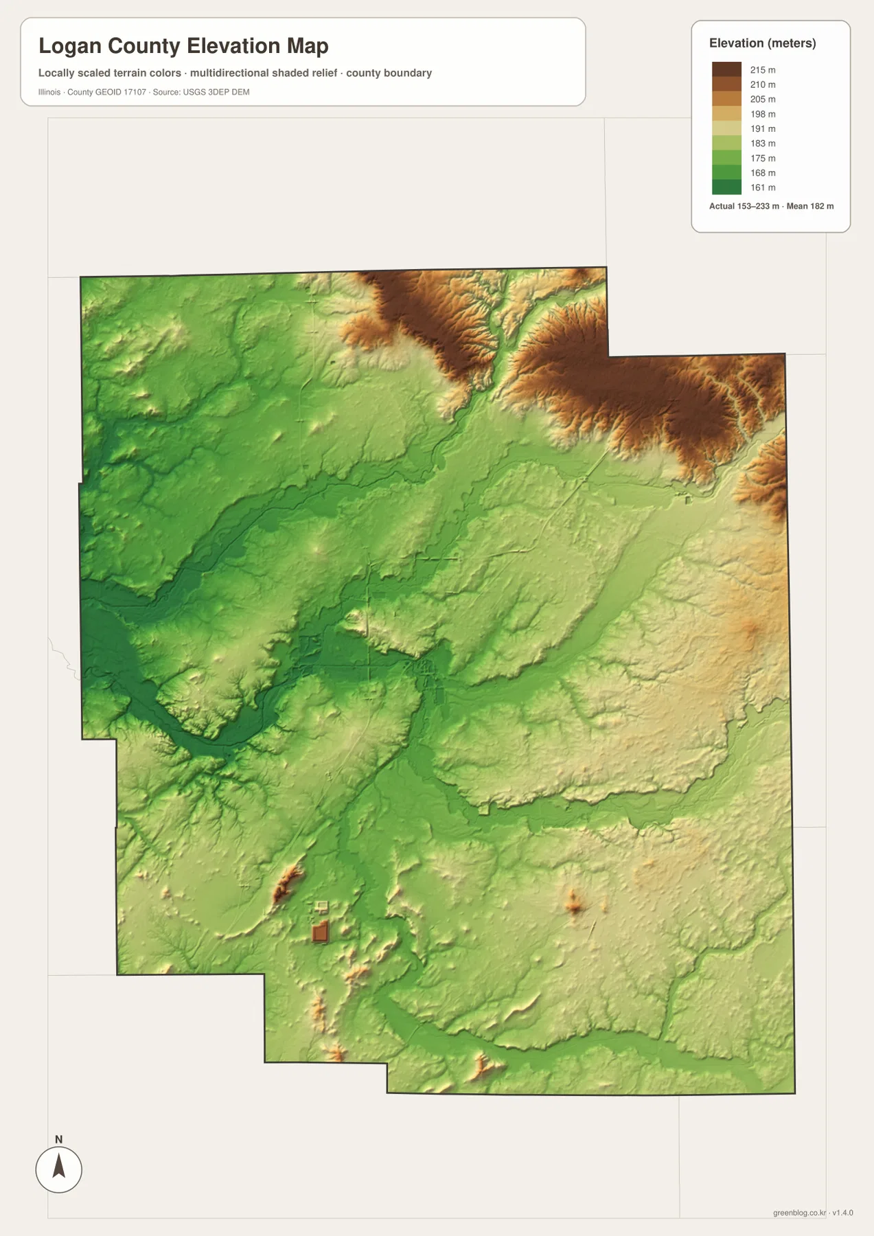
The elevation surface is generalized for county-scale comparison. It should not be treated as a survey, construction elevation, parcel measurement, or engineering model. For ordinary map reading, however, it adds useful context: compare it with the water map and the lower corridors around Sugar Creek, Kickapoo Creek, Lake Fork, and other branches become easier to recognize.
Choosing the map that matches the question
Use the county map first when the main question is where Lincoln, Atlanta, Mount Pulaski, Elkhart, and the major roads sit within the boundary. The city map is better when the goal is to compare the six highlighted communities without the extra road and settlement labels. For named creeks and branches, the terrain and water map provides the clearest view. The elevation map is the right choice for comparing the northeast high ground with the lower central and western parts of the county.
The maps are most useful when two views are compared. Atlanta, for example, can be located quickly on the city map, tied to Route 55 on the county map, and then placed within the higher northeastern terrain on the elevation map. Lincoln can be read in the opposite way: the county map shows its central road position, while the water and elevation maps show the smaller branches and lower terrain around the county center. That combination gives more local context than repeating the same place names on one map alone.
Frequently Asked Questions
Which map is best for comparing Lincoln, Atlanta, and Mount Pulaski?
The ranked city map is the fastest way to compare their locations: Lincoln is central, Atlanta is northeast, and Mount Pulaski is southeast. If road context matters, switch to the county map to see Route 55 toward Atlanta and the routes leading south and southeast from Lincoln toward Mount Pulaski. Elkhart in the southwest gives another useful reference point for the southern half of the county.
Why does the northeast stand out on the Logan County elevation map?
The northeast is shown with the broadest tan and brown areas, indicating higher terrain within the county’s 153–233 m range. The center and west are lower and contain many creek corridors. Comparing the elevation map with Sugar Creek and Kickapoo Creek on the water map makes the contrast between the northeast high ground and the lower drainage areas much easier to see.
What is included in the downloadable ZIP?
The ZIP contains four high-resolution JPG files: the county and road map, ranked city map, terrain and water map, and elevation map. Each image is 3638 × 2572 pixels. The article uses smaller WebP versions for on-screen viewing, while the JPG files are better suited to close inspection and print. The water and elevation maps remain general reference products rather than flood, legal, survey, or engineering documents.
Map File Information
Download the Logan County county map, ranked city map, terrain and water map, and elevation map together as high-resolution JPG files.
- Included Files: Use only the versions confirmed in the article and supplied images
- File Type: Use the confirmed download contents
- Intended Use: Printing, education, presentations, and map-based projects
Related Maps
Sources and references
- U.S. Census Bureau TIGER/Line Shapefiles – county boundaries, roads, and place reference
- USGS National Hydrography – rivers, creeks, and hydrography reference
- USGS 3D Elevation Program – elevation and terrain reference
- Destination Logan County – local information for Lincoln, Atlanta, Mount Pulaski, and other Logan County communities
- City of Lincoln Tourism – local history, Route 66, and visitor information for Lincoln
Green Map creates custom-edited map images using open geographic data sources such as geoBoundaries, Natural Earth, OpenStreetMap, and government open data.
These maps are edited visual materials, not raw data files, and are provided for education, documents, presentations, and graphic reference.