Johnson County in southern Illinois is easiest to understand from Vienna, where the county’s main north-south and east-west roads meet between the higher northern hills and the lower Cache River country. This page shows the county boundary, major roads, community locations, lakes and streams, and the broad elevation change from roughly 71 to 262 meters. You can also download the high-resolution JPG versions of all four supplied maps directly from this page as one ZIP file, which is useful when you need larger labels, a printable copy, or a closer look than the browser previews provide.
Vienna works well as the first reference point because U.S. 45 runs through it from north to south while Illinois Route 146 crosses from west to east. Goreville lies to the northwest, New Burnside to the northeast, Buncombe to the west, Cypress to the southwest, Belknap near the southern edge, and Simpson to the east. Those positions become more meaningful when the terrain is added. The north is cut by closely spaced ridges and narrow stream valleys, while the southern part of the county opens into lower ground around the Cache River and Old Cache River Slough.
The supplied maps separate those ideas so they are easier to see. The road-and-boundary map is the best starting point for direction, the community map makes the scattered settlement pattern clearer, the terrain-and-water map highlights Lake of Egypt, the Little Saline River, Dutchman Creek, Bay Creek, Johnson Creek, and the Cache River, and the elevation map shows where the higher ridges give way to southern lowlands. Rather than treating them as four versions of the same picture, the sections below use each map where it explains a specific part of Johnson County best.
Table of Contents
Vienna gives the county its clearest road reference
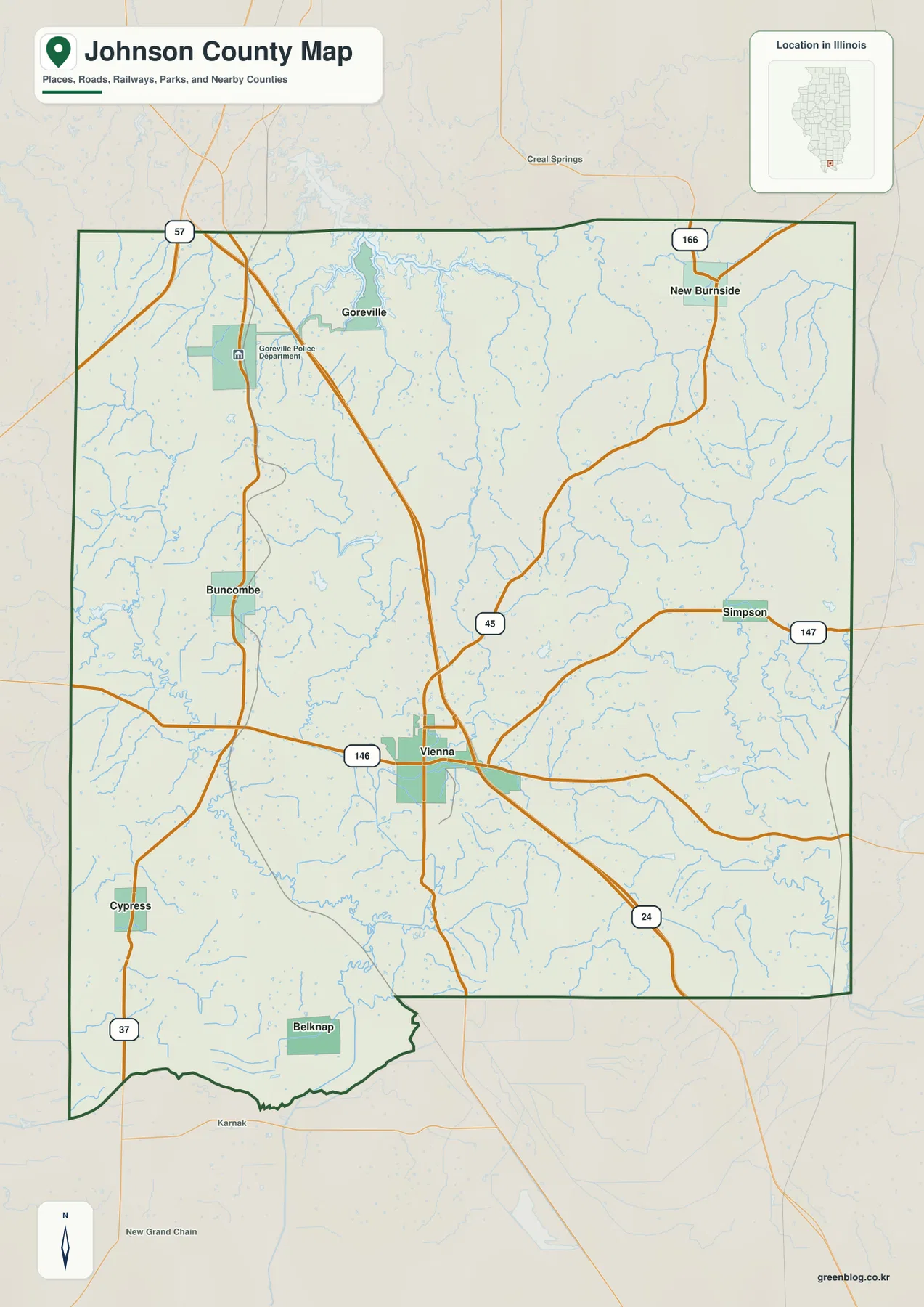
On the county map, Vienna sits close to the middle and provides a practical way to organize everything else. U.S. 45 approaches from the north, passes through Vienna, and continues south, while Illinois Route 146 crosses the county from west to east. Once those two routes are located, Goreville falls naturally to the northwest, New Burnside to the northeast, Buncombe to the west, Cypress to the southwest, Belknap to the south, and Simpson to the east. A statewide map may show only where Johnson County lies within Illinois; this view shows how its main communities are arranged inside the boundary.
The road pattern becomes less regular north of Vienna. Around Goreville, short valleys and ridges create a more broken landscape, and several roads bend around that relief rather than forming a simple rectangular grid. The Illinois Department of Natural Resources describes nearby Ferne Clyffe State Park as part of the Shawnee Hills, with prominent rock formations, bluffs, and deeply cut scenery. The map on this page does not show individual park trails or cliff names, but that official description helps explain why the northern side looks more rugged than the lower country farther south.
New Burnside provides a second northern reference point near Route 166, while Simpson is shown farther east near Route 147. Vienna’s east-west connection along Route 146 makes it easier to place those communities in relation to Pope and Saline counties beyond the eastern boundary. On the other side, Buncombe and Cypress help define the western half, with Union, Pulaski, and Massac counties providing additional orientation outside Johnson County. These neighboring labels are useful because they show where the county sits within the wider southern Illinois road network without requiring a separate regional map.
The southern edge is more irregular, and Belknap lies close to that boundary. Nearby labels outside the county, including Karnak and New Grand Chain, help the reader understand where the map continues into surrounding areas. Roads and settlements are more widely spaced here than around Vienna, and the water network becomes increasingly important to the shape of the landscape. The county map is therefore best treated as an orientation tool rather than a turn-by-turn navigation product; current road closures, construction, and driving conditions should be checked separately.
Vienna’s central appearance also matches its administrative role. Illinois Secretary of State archival information identifies Vienna as the Johnson County seat, a position it has held since the early county period. That history is not the main subject of this page, but it helps explain why Vienna remains such a useful geographic anchor. For a first reading of the county, finding Vienna and then following U.S. 45 and Route 146 outward is the quickest way to establish direction before moving to the more specialized maps.
Communities are scattered across very different terrain
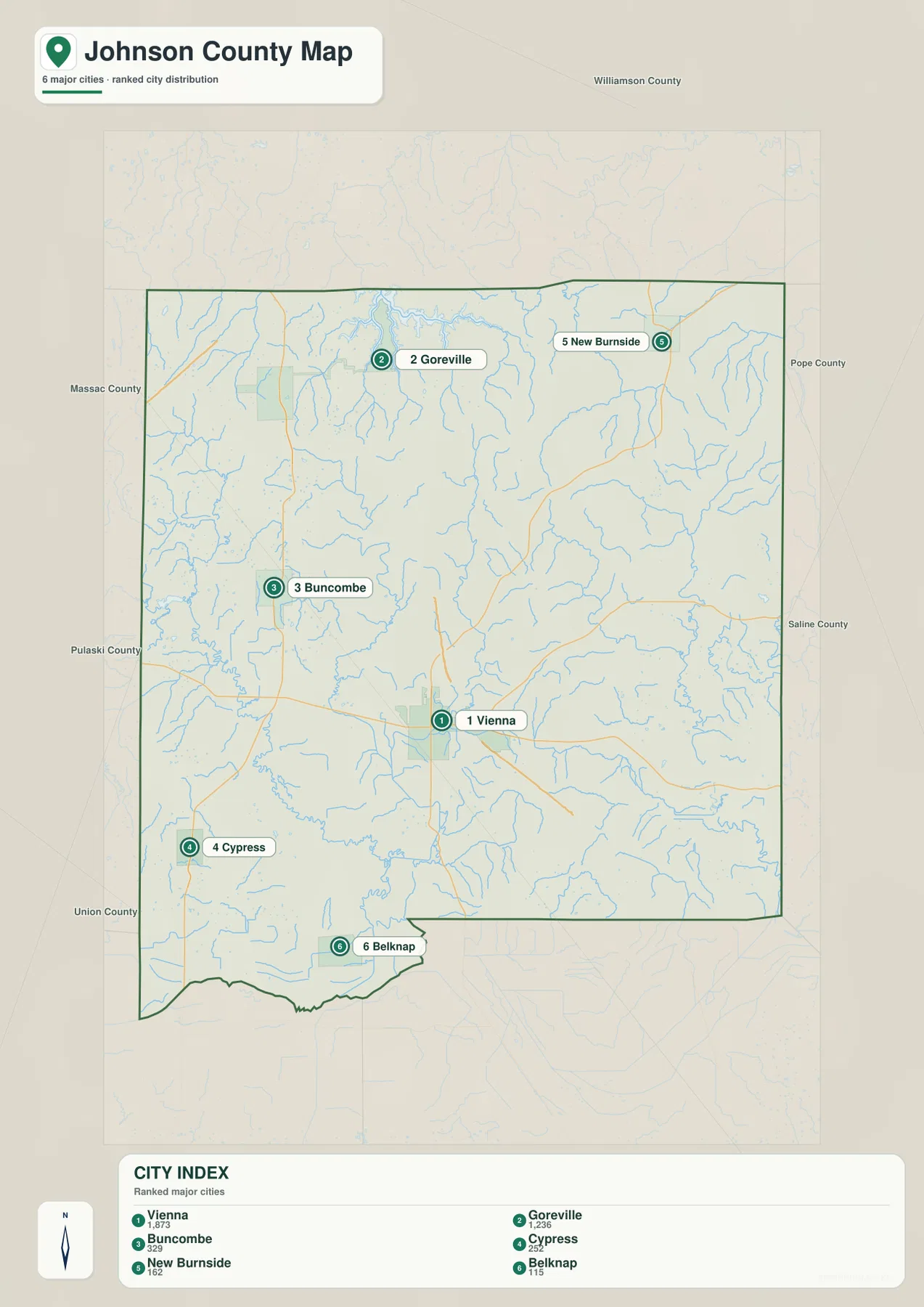
The community map removes much of the road and stream detail so the spacing of six named places becomes easier to see. Vienna occupies a central-southern position, Goreville is well to the northwest, and New Burnside sits in the northeast. Buncombe lies to the west of the center, Cypress is farther southwest, and Belknap is close to the southern boundary. The pattern matters because Johnson County is not a place where several large towns form one continuous urban corridor; its communities are relatively small and separated by hills, valleys, wooded areas, and stream networks.
The index printed on the supplied map lists Vienna at 1,873, Goreville at 1,236, Buncombe at 329, Cypress at 252, New Burnside at 162, and Belknap at 115. Those figures are useful here as reference values that show the relative scale of the labeled communities. They should not be treated as a substitute for the newest census estimate or a current municipal population table. For map reading, the important point is that Vienna and Goreville stand out while the smaller places are spread widely around the county.
Vienna and Goreville illustrate the north-south terrain difference especially well. Vienna is located where the main roads cross in a rolling central area, while Goreville sits closer to the strongly ridged northern landscape. On the elevation map, the Goreville side contains more brown and orange high ground with narrow green valleys cut between ridges. Remembering the two locations from the simplified community map makes that relief pattern easier to recognize later.
Cypress and Belknap are useful reference points for the opposite side of the county. Cypress lies southwest of Vienna, and Belknap is farther south near the low Cache River country. When those two locations are carried over to the terrain-and-water map, the Cache River and Old Cache River Slough appear much closer than they do to the northern communities. The elevation map also shifts toward broad green tones in this part of the county, showing that the settlement setting changes as the land descends toward the southern lowlands.
New Burnside and Buncombe help show the county’s east-west width. They sit on opposite sides of a broad interior that includes Vienna’s northern hills and several drainage lines. A simple list of town names would not reveal that difference, but the map makes it clear that reaching each community involves a different part of the county and a different terrain setting. For classroom work or a regional overview, this simplified map is often the clearest way to introduce the settlements before returning to the more detailed road map.
The water map shifts from Lake of Egypt to the Cache River lowlands
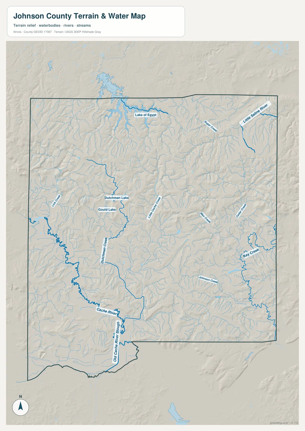
Johnson County does not have one major river running straight through its center. Instead, the map shows many short streams and several distinct water features spread across the county. Lake of Egypt is the largest obvious body of water near the northern edge, with short tributaries entering from the surrounding hills. The Little Saline River and Sugar Creek appear in the northeastern part of the map, where the channels follow narrow valleys between closely spaced ridges.
Moving toward the center and west, Dutchman Lake and Gould Lake provide smaller landmarks. Dutchman Creek runs south through the western half, while Little Cache Creek, Johnson Creek, Bay Creek, and numerous unnamed tributaries cross other parts of the county. The density of blue lines is important because it shows how strongly the terrain is divided by drainage. Even areas that look relatively open on the road map contain many small valleys and watercourses when the terrain layer is added.
The Cache River becomes the defining water feature in the south. Old Cache River Slough is also labeled near the lower boundary, and several smaller channels occupy the surrounding low ground. Illinois DNR describes Cache River State Natural Area as an important wetland landscape extending across Johnson, Massac, and Pulaski counties. The supplied map does not draw the legal boundary of that natural area or classify every wetland parcel, so the presence of a blue channel should not be interpreted as an exact wetland limit.
The relationship between water and relief becomes clearer when this image is compared with the elevation map. In the north, many tributaries occupy narrow green corridors between higher ridges. Farther south, those low corridors broaden, and the Cache River lies within a much wider lowland. Dutchman Creek and Little Cache Creek show the same general tendency on a smaller scale. Instead of memorizing every stream name, readers can use the waterways to locate the valleys and then use the elevation colors to see the high ground that separates them.
This is a county-scale geographic reference, not a flood determination or a navigation chart. Stream-line width does not represent a floodplain, seasonal water levels can change, and the map does not define legal water or property boundaries. Anyone who needs current flooding, water levels, preserve limits, or regulatory information should use the relevant agency product. For general orientation, however, it clearly places Lake of Egypt in the northern part of the county and the Cache River in the lower southern landscape.
Elevation falls from the northern ridges toward the south
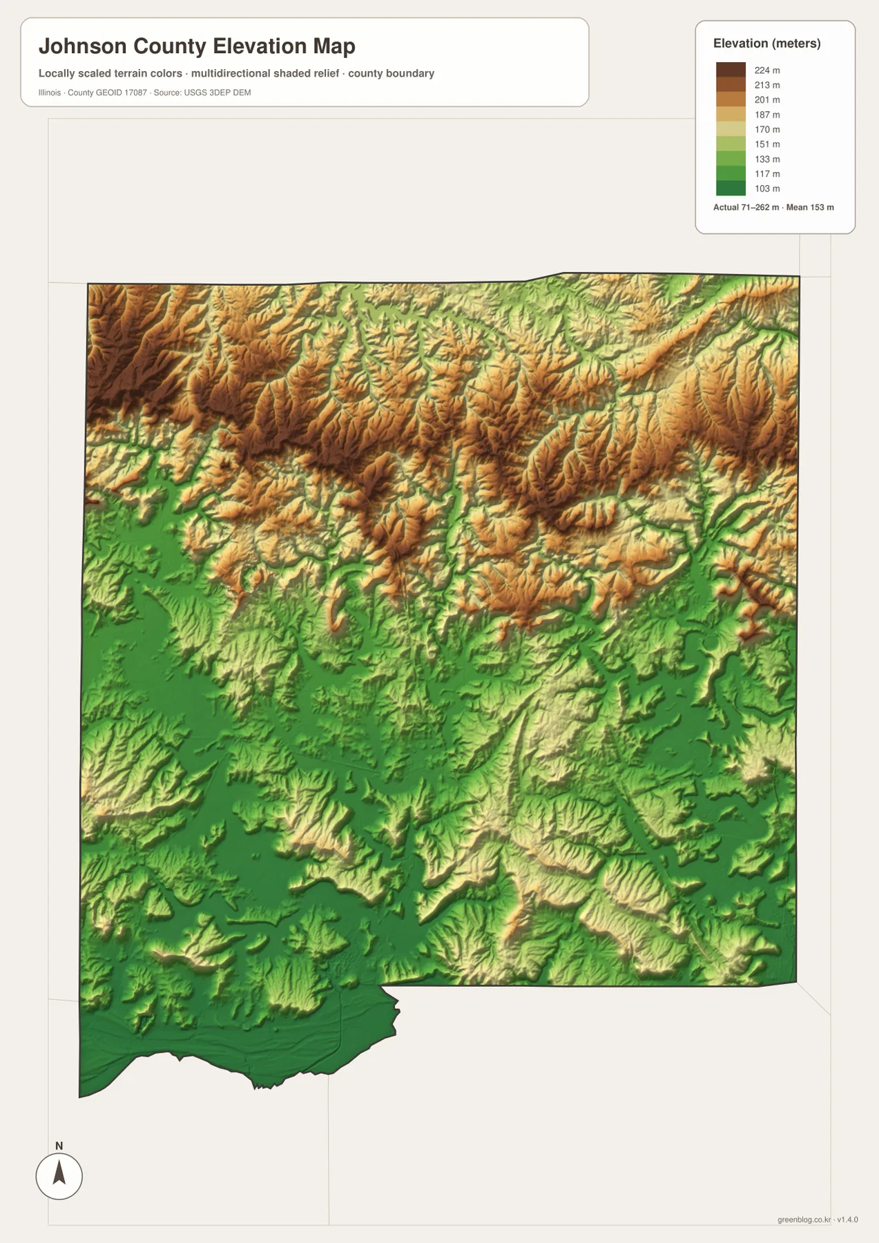
The elevation map provides the clearest single picture of Johnson County’s north-south contrast. Its legend gives an actual range of about 71 to 262 meters and a mean close to 153 meters. Browns and oranges cover much of the northern side, where the higher ground is broken into many narrow ridges. Greens become more common toward the south, especially around the Cache River. The change is broad enough to affect the character of whole parts of the county rather than simply marking one isolated hill.
The most rugged pattern appears around the Goreville side and other northern areas. Ridges branch repeatedly, and narrow low valleys separate them. Nearby Ferne Clyffe State Park gives a real-world example of this terrain; Illinois DNR highlights cliffs, rock formations, and deeply cut Shawnee Hills scenery there. The county elevation map is not a park topographic or trail map, but it places that rugged setting within a larger landscape and shows how quickly the ground changes outside the main valleys.
Vienna lies in a more moderate zone. The surrounding surface is still rolling and crossed by streams, yet it is lower and less tightly ridged than the highest northern areas. That helps explain the map’s visual balance: Vienna is central not only in the road network but also between two different terrain settings. The map cannot prove why every road was built along a particular course, but it does show that U.S. 45 and Route 146 pass through ground that is less extreme than many of the northern ridges.
The southern third provides the strongest contrast. Near Cypress, Belknap, the Cache River, and Old Cache River Slough, broader green areas mark lower ground. Small ridges still rise within the southern part of the county, so it would be inaccurate to call the entire area perfectly flat. A better description is that high ridges are concentrated in the north while the low stream valleys widen toward the south. When the water and elevation maps are viewed together, the Cache River falls directly within that broader low belt.
The elevation colors are intended for county-wide comparison rather than survey work. The 71–262 meter range is useful for understanding why Goreville’s setting looks different from the Cache River side, but it is not precise enough for a property survey, construction design, drainage calculation, or engineering decision. For those needs, USGS 3D Elevation Program data and qualified surveying resources are more appropriate. Here the elevation map is best used as a clear visual summary of the county’s major relief differences.
Matching each map to a practical use
If the main question is direction, begin with the road-and-boundary map. It keeps Vienna, the main numbered routes, the county outline, and surrounding communities in one view, making it the most useful option for explaining how places relate to one another. The community map is cleaner when road detail is unnecessary and the goal is simply to show where Vienna, Goreville, Buncombe, Cypress, New Burnside, and Belknap sit across the county.
For natural geography, use the terrain-and-water map with the elevation map. Locate Lake of Egypt, the Little Saline River, Dutchman Creek, Bay Creek, and the Cache River first, then check the same areas against the relief colors. Northern streams fit into narrow valleys between ridges, while the southern Cache River occupies broader low ground. This paired reading is more useful than a list of stream names because it shows how drainage and terrain fit together.
A classroom or local-history presentation may use the maps in a different sequence. Vienna can establish the county’s main road center, Goreville can introduce the higher Shawnee Hills terrain, and Cypress or Belknap can provide reference points for the lower southern landscape. The maps are designed for those broad geographic relationships. Specialized questions about park trails, parcel lines, flood zones, live road conditions, or engineering elevations require the appropriate official source instead.
The browser maps use WebP images for convenient viewing, but the downloadable files are high-resolution JPGs. The ZIP includes the county road-and-boundary map, community map, terrain-and-water map, and elevation map as separate images. Downloading the ZIP is the better choice when you want to zoom in on smaller labels, print a map, place one image in a presentation, or compare the maps side by side at a larger size.
Frequently Asked Questions
What is the easiest way to compare Goreville and Belknap from Vienna?
Start with Vienna on the road-and-boundary map, where U.S. 45 and Illinois Route 146 meet. Goreville lies northwest of Vienna in the higher northern hills, while Belknap is south of Vienna near the lower Cache River side of the county. The community map makes their positions easy to compare, and the elevation map adds the major terrain difference between the two areas.
How do Lake of Egypt and the Cache River differ on the supplied maps?
Lake of Egypt appears as a large water body near the northern edge, surrounded by short tributaries and strongly ridged terrain. The Cache River lies in the south within a broader lowland, with Old Cache River Slough and other channels nearby. They are most useful as reference points for comparing the county’s northern lake-and-valley landscape with its southern river lowlands rather than as a single continuous water route.
Can the 71–262 meter elevation range be used for a property survey?
No. The elevation map is a county-scale visual reference for comparing higher northern ridges with lower southern terrain. It is not survey-grade and should not be used for construction design, drainage calculations, or an exact property elevation. More precise work should rely on USGS source data and qualified surveying or engineering resources.
Map File Information
Download one ZIP containing four high-resolution JPG maps of Johnson County: the road-and-boundary map, community map, terrain-and-water map, and elevation map. The larger files are useful for examining Vienna and surrounding communities, the Lake of Egypt and Cache River drainage network, and the contrast between the northern ridges and southern lowlands.
- Included Files: 4 high-resolution JPG images
- File Type: ZIP archive containing JPG images
Related Maps
Sources and references
These official sources provide additional context for Johnson County administration, natural areas, boundaries, waterways, and elevation. The maps on this page are intended for general county orientation, so current legal, engineering, flood, or regulatory questions should be checked against the original agency data.
- Illinois Secretary of State – Johnson County – county history and Vienna’s county-seat record
- Illinois Department of Natural Resources – Ferne Clyffe State Park – Shawnee Hills terrain and natural features near Goreville
- Illinois Department of Natural Resources – Cache River State Natural Area – wetland and natural-area context in southern Johnson County
- U.S. Census Bureau TIGER/Line Shapefiles – county boundary and geographic reference data
- USGS National Hydrography – official hydrography data
- USGS 3D Elevation Program – elevation source data
Green Map creates custom-edited map images using open geographic data sources such as geoBoundaries, Natural Earth, OpenStreetMap, and government open data.
These maps are edited visual materials, not raw data files, and are provided for education, documents, presentations, and graphic reference.