The Jackson County Illinois Map download on this page includes the full-size JPG files behind the four previews below. Carbondale and Murphysboro form the central road reference, Route 13 links them across the county, and the other views add the selected city ranking, the Mississippi–Big Muddy water system, and relief ranging from 101 to 259 meters. The maps also make it easy to place De Soto, Ava, Grand Tower, and Makanda around those central points.
Jackson County changes character sharply from west to east and again from the Carbondale area south toward Makanda. The Mississippi River occupies the low western edge, rugged hills rise across much of the west-central interior, lower green terrain spreads across the east, and stronger relief returns in the southeast. Reading the road, water, and elevation files together gives a much more useful picture than treating the county as a single flat surface.
Table of Contents
Route 13 gives Carbondale and Murphysboro a common reference line
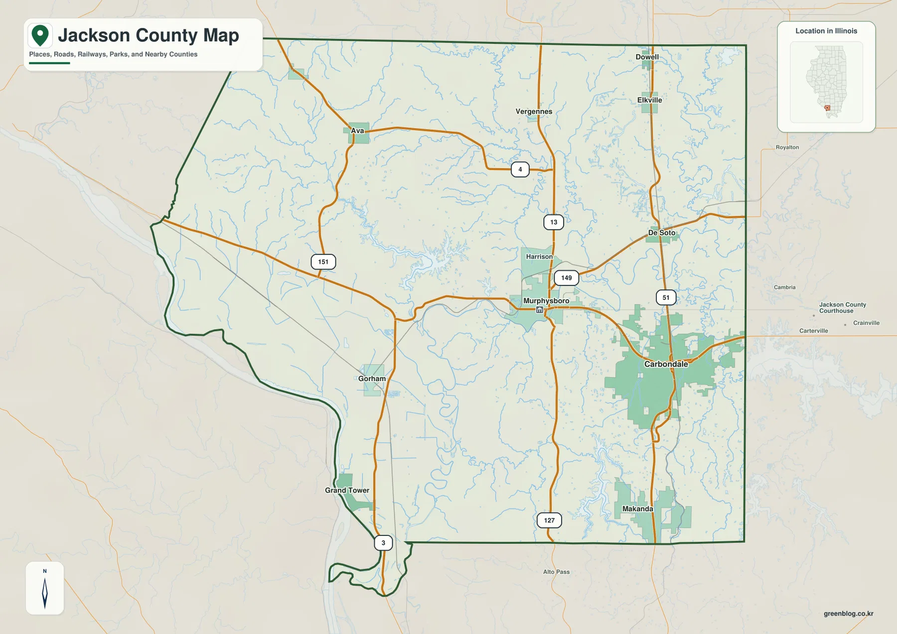
Route 13 is the quickest way to orient the middle of Jackson County. Murphysboro sits west of center and Carbondale occupies a larger built-up area to the east. Route 149 branches southeast from Murphysboro, while Route 51 runs north–south near Carbondale and continues toward De Soto in the north and Makanda in the south. Once those two cities and the Route 13 line are fixed, the rest of the road map becomes much easier to follow.
The northern half adds Ava near Route 4 and Route 151, with Vergennes, Dowell, Elkville, and De Soto spread across the northeast. Ava is noticeably west of the main Carbondale–De Soto corridor, giving the county a second set of rural road references. Farther south, Route 127 runs through the central interior and Route 3 appears near Grand Tower along the southwestern river side.
Gorham lies inland from the Mississippi side, while Grand Tower sits much closer to the river. Makanda anchors the southeast near Route 51. The official Jackson County Community Resources page identifies Carbondale and Murphysboro as the county’s two largest cities and lists Ava, Grand Tower, and several villages including De Soto, Dowell, Elkville, Makanda, and Vergennes. That county list fits the broader settlement pattern visible on the supplied map.
The county outline itself is useful. Its western edge bends with the Mississippi River, the northwest side angles inward, and the southwestern end narrows as the river curves around it. The east and much of the south are straighter. Holding that shape in mind helps when the water map introduces the Mississippi River, Big Muddy River, and the many eastern lakes and creeks.
Carbondale leads a six-place CITY INDEX spread from Ava to Makanda
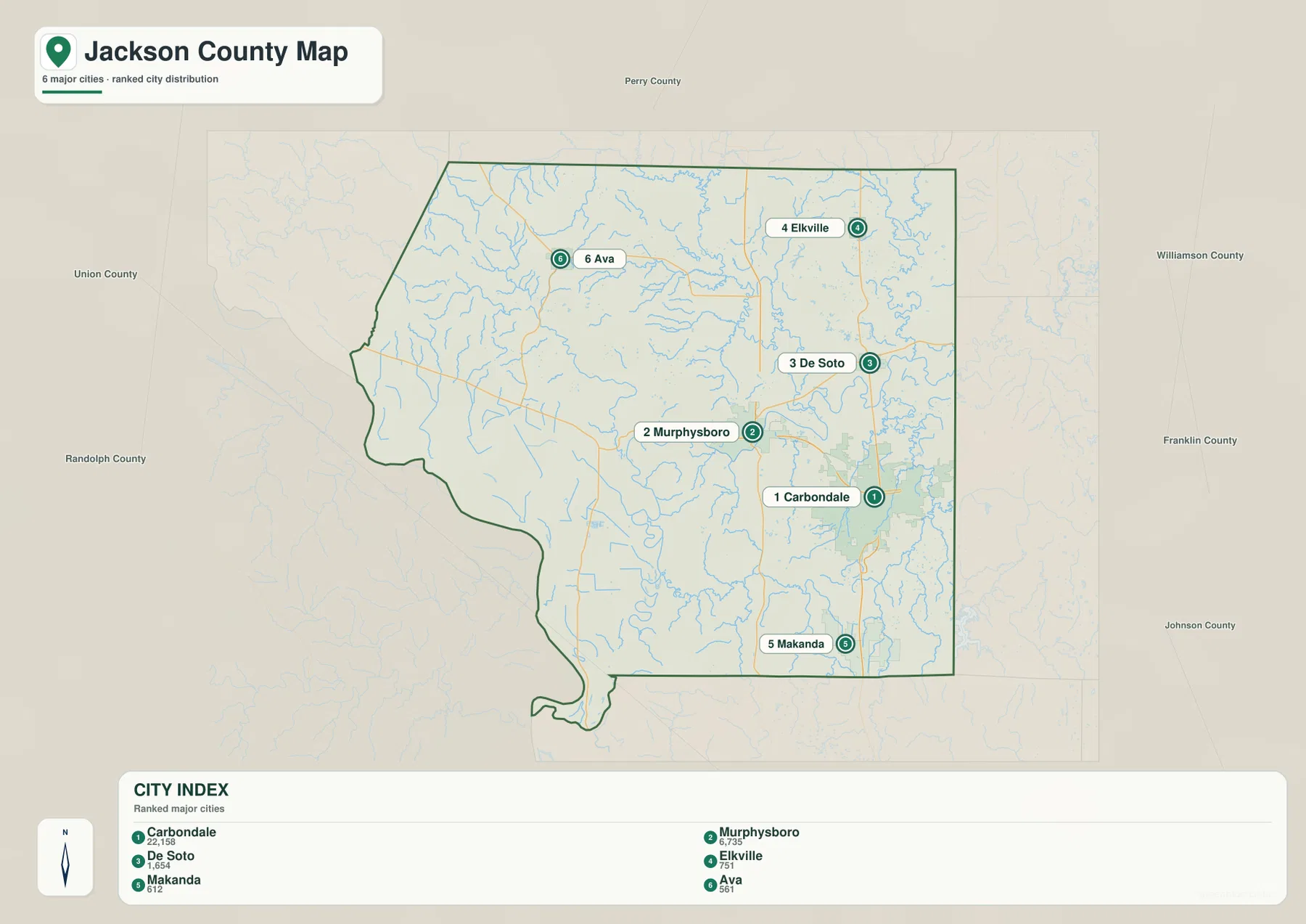
The ranked-city file reduces the settlement layer to six labeled points. Carbondale is first with a printed index value of 22,158, Murphysboro is second at 6,735, and De Soto is third at 1,654. Elkville follows at 751, Makanda at 612, and Ava at 561. These numbers belong to the supplied CITY INDEX and are used to explain that map; they are not presented here as current Census population estimates.
Their positions cover several parts of the county. Carbondale and Murphysboro dominate the central and eastern middle, De Soto and Elkville sit north of them, Ava stands apart in the northwest, and Makanda marks the south. That spread makes the layer useful for seeing settlement spacing rather than merely reading a ranked list.
Neighbor labels provide a regional frame: Perry County is north, Williamson and Franklin counties are east, Johnson County is southeast, and Union and Randolph counties lie to the west. Smaller Jackson County places such as Vergennes, Dowell, Gorham, and Grand Tower are omitted from the ranked layer, so the general road map remains the better choice when every available place label matters.
The Jackson County government’s Community Resources page independently lists Carbondale and Murphysboro as the two largest cities and includes Ava, Grand Tower, De Soto, Dowell, Elkville, Makanda, Vergennes, and other communities. That official list is helpful because it separates the county’s actual community network from the narrower six-point CITY INDEX used in the visualization.
Big Muddy River connects the interior to the Mississippi River lowlands
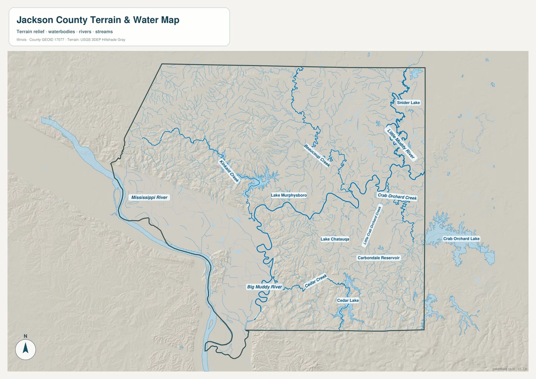
The terrain-and-water map is dominated by the Mississippi River on the west and the Big Muddy River inside the county. Big Muddy bends south and west toward the Mississippi corridor, while Kinkaid Creek approaches from the rugged western interior. Lake Murphysboro provides an easy landmark where the creek and hill country meet, and Beaucoup Creek winds through the north-central drainage.
The eastern side contains a different collection of water features. Snider Lake and the Little Muddy River appear in the northeast, Crab Orchard Creek lies farther south, and Little Grassy Creek crosses the area southeast of Carbondale. Carbondale Reservoir and Lake Chautauqua add small named water bodies near the central-southeastern part of the map. Cedar Creek and Cedar Lake continue the pattern farther south, while Crab Orchard Lake is visible beyond the county’s eastern boundary.
The map therefore separates two very different water settings. The southwest is shaped by a large river and broad low ground, while the east and southeast contain multiple creeks, reservoirs, and lakes set within rolling terrain. Moving from one side to the other explains why a simple road map can hide important differences in drainage and local topography.
The blue features should be read as geographic locations, not as live conditions. The file contains no flood probability, river stage, water quality, navigation status, public-access rule, or property boundary. Mississippi River and Big Muddy River conditions can change substantially over time, and smaller creeks can respond quickly to rainfall. Current USGS or local-agency information is necessary for safety and property decisions.
Western ridges rise well above the low river edge and eastern basin
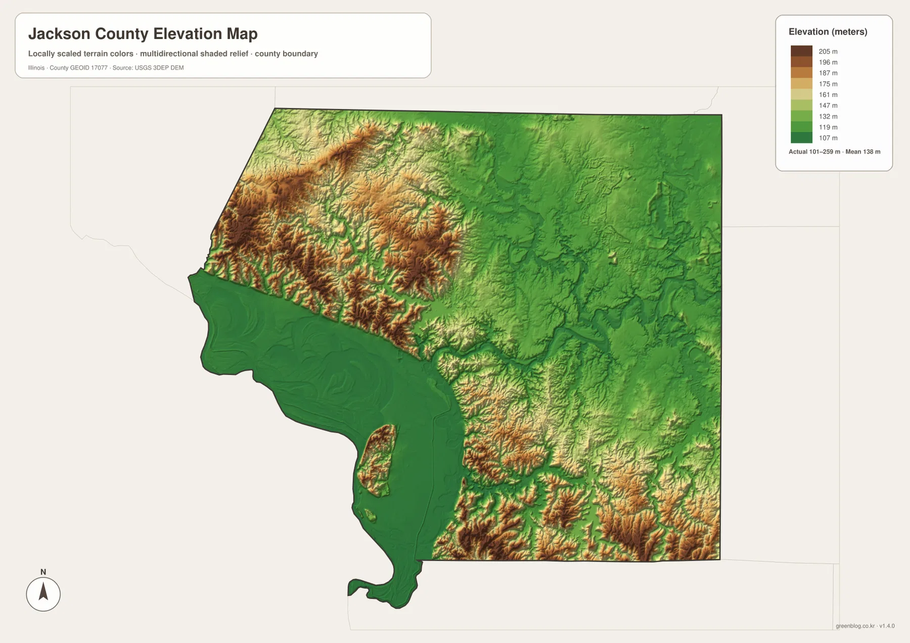
The elevation legend prints an actual range of 101–259 meters and a mean of 138 meters. The displayed color bar itself runs from about 107 to 205 meters. High tan and brown terrain is concentrated across much of the northwest and west-central county, while deep green dominates the Mississippi River lowlands and broad portions of the east. The contrast is one of the strongest visible differences in the Jackson County map set.
West and northwest of Murphysboro, narrow valleys cut through steep ridges, and the colors change quickly over short distances. Those valleys correspond well with the Kinkaid Creek area on the water map. The eastern side around and beyond Carbondale is lower overall, but the southeast rises again toward Makanda, where the terrain becomes more strongly textured and warmer in color.
Giant City State Park provides official context for that southeastern relief. The Illinois Department of Natural Resources describes the park south of Carbondale near Makanda as a landscape of massive sandstone bluffs and narrow rock corridors within the Shawnee National Forest. The downloadable elevation map is not a park trail map, but the stronger relief south of Carbondale helps place that landscape in a county-wide setting.
The elevation file is intended for broad comparison rather than engineering. The 101–259 meter range is useful for describing the county’s low and high areas, but it does not certify the elevation of a parcel, road centerline, building pad, or drainage structure. Precise site work requires source elevation data such as USGS 3DEP and professional field measurements.
Carbondale to Makanda shows how quickly the southeast changes
Carbondale appears as the largest built-up patch on the general map and sits beside Route 51. The elevation view places much of the surrounding area in lower green terrain. Following Route 51 south toward Makanda, the relief becomes more irregular and higher colors return. The water map adds Little Grassy Creek, Cedar Creek, nearby reservoirs, and lakes to the same corridor.
IDNR’s Giant City State Park page helps explain that shift without inventing features that are not on the maps. The park is near Carbondale and Makanda and is known for sandstone bluffs, narrow passages, forest, and hiking terrain. Those details come from the official park source; the county JPGs simply provide the larger position of that rugged southeast within Jackson County.
A westward trip from Murphysboro tells a different story. Lake Murphysboro and Kinkaid Creek lie among the higher western ridges, but farther southwest the Big Muddy and Mississippi river corridor drops into broad green lowland. The county therefore changes from hill country to river plain and back to upland terrain over relatively short map distances.
Choose the Jackson County file by what you need to see
For roads and settlement positions, begin with Carbondale and Murphysboro on the general county map, then use Route 13 as the central east–west guide. Add De Soto, Elkville, Ava, Grand Tower, Gorham, and Makanda only after that central line is clear. The CITY INDEX layer is better when a clean comparison of the six selected communities is all that is needed.
For water, follow the Mississippi River and Big Muddy River first, then move to Kinkaid Creek, Beaucoup Creek, Little Muddy River, Crab Orchard Creek, Little Grassy Creek, and the named lakes. For terrain, use the elevation file to separate the western hills, river lowland, lower eastern basin, and southeastern uplands.
The embedded WebP copies are convenient for fast page viewing, but the downloadable JPGs are 3638 × 2572 pixels and preserve more room for small labels. They are practical for printed handouts, classroom reference, presentation slides, or side-by-side county comparison. Keeping the original aspect ratio avoids distorting roads, boundaries, and terrain.
Legal boundaries, parcels, flood studies, navigation, and engineering require different source products. Census TIGER/Line is appropriate for official geographic reference, USGS National Hydrography for water-source data, and USGS 3DEP for precise elevation information. The maps on this page are designed for geographic orientation and visual comparison.
Full-size JPG files for Jackson County
The ZIP groups the general county map, CITY INDEX map, terrain-and-water map, and elevation map in their original JPG dimensions. Opening the files separately makes small road and water labels easier to inspect than in the browser previews, and placing them side by side is useful when one town or creek needs to be checked against the relief surface.
Frequently Asked Questions
Are the CITY INDEX values current official population counts?
No. They are the values printed on the supplied ranked layer: Carbondale 22,158, Murphysboro 6,735, De Soto 1,654, Elkville 751, Makanda 612, and Ava 561. They explain this map’s ordering only. Current official population figures should be checked with the U.S. Census Bureau.
Is Giant City State Park inside Jackson County?
Illinois DNR places Giant City State Park south of Carbondale near Makanda, with the park extending across Jackson and Union counties. The four county images do not draw the park boundary or trail network, so current IDNR maps should be used for entrances, trails, camping, and recreation planning.
Can the 101–259 meter elevation file be used for surveying?
No. The relief surface compares broad county-scale high and low areas; it does not provide certified point elevations or engineering tolerances. Parcel surveys, building elevations, drainage design, or road grading require original elevation data and professional measurement rather than a color readout from this JPG.
Map File Information
The archive contains the Jackson County general map, CITY INDEX map, terrain-and-water map, and elevation map as high-resolution JPG files.
- Included Files: 4 JPG files
- Printable Size: 3638 × 2572 pixels each
Related Maps
Sources and reference data
- Jackson County, IL – Community Resources: official county information listing Carbondale, Murphysboro, Ava, Grand Tower, and several Jackson County villages
- Illinois DNR – Giant City State Park: official context for the sandstone bluffs and recreation landscape south of Carbondale near Makanda
- U.S. Census Bureau TIGER/Line Shapefiles: official geographic boundary and feature reference data
- USGS National Hydrography: source information for rivers, streams, lakes, and related water features
- USGS 3D Elevation Program: source elevation data when more precision is required than the relief JPG provides
Green Map creates custom-edited map images using open geographic data sources such as geoBoundaries, Natural Earth, OpenStreetMap, and government open data.
These maps are edited visual materials, not raw data files, and are provided for education, documents, presentations, and graphic reference.