The map files for Henderson County, Illinois can be downloaded directly from this page. The article previews the county road-and-boundary map, a ranked-city map, a terrain-and-water map, and an elevation map, while the ZIP provides the original high-resolution JPG files. Together they show Oquawka on the western river edge, Stronghurst and Biggsville farther inland, major routes such as 164, 34, and 94, named creeks and floodplain lakes, and a county-wide elevation range of roughly 148 to 243 meters.
Henderson County is especially easy to understand when the western lowlands are compared with the higher, more dissected ground to the east. The general map gives the fastest orientation, but the water and elevation views explain why the western side looks so different from the interior. The descriptions below stay with features that are visible in the supplied maps or supported by the linked public sources, and the numbered city values are treated as map-index values rather than live population estimates.
Table of Contents
Oquawka and the western river edge
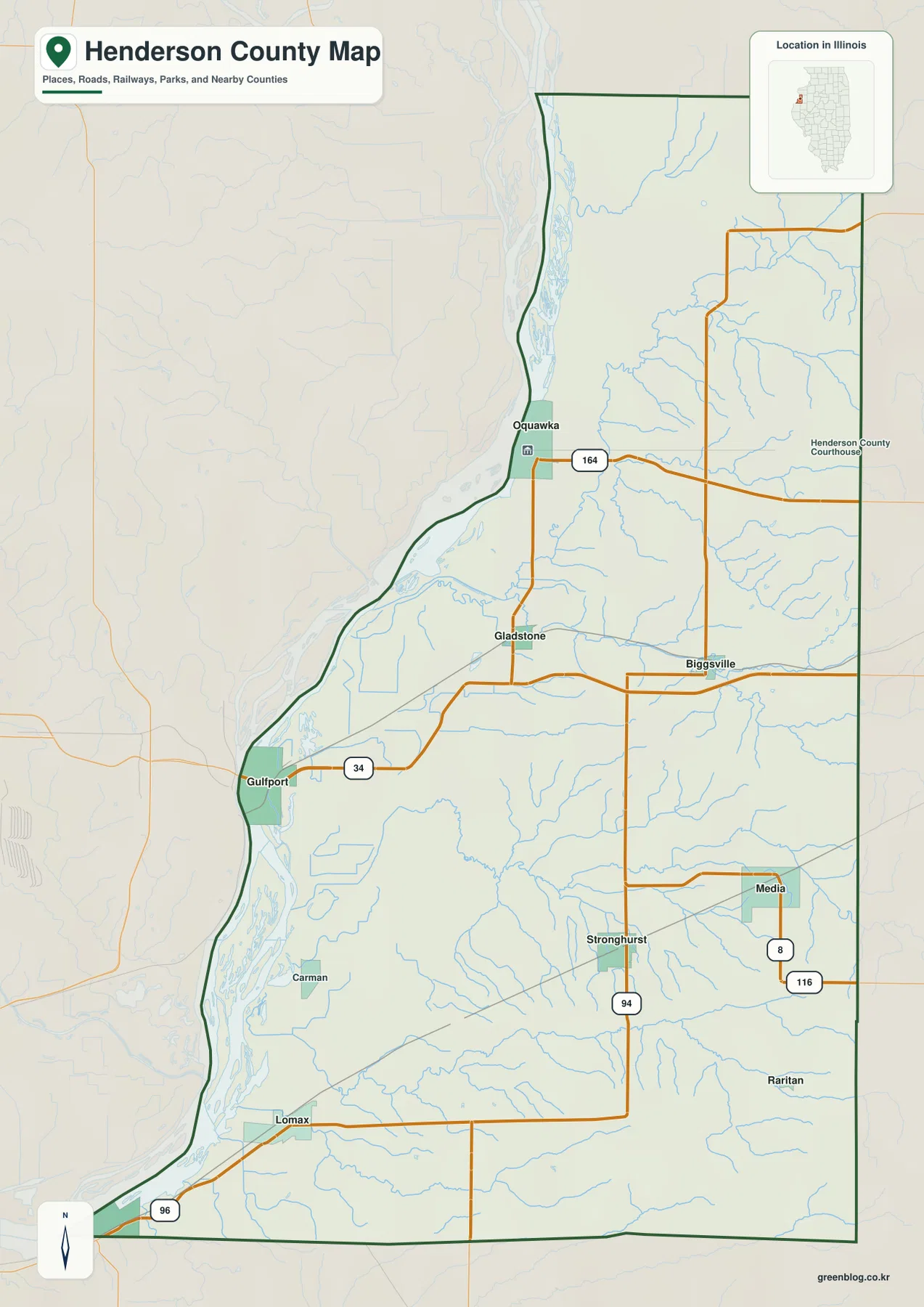
The county outline is distinctive because its western boundary bends with the river while the eastern side is much straighter. Oquawka sits on that western edge and provides a useful starting point for reading the map. Route 164 runs east from Oquawka across the northern part of the county, while Gladstone appears farther south near the river. Continuing down the western side brings Gulfport, Carman, and Lomax into view, all of them separated from the more inland pattern around Biggsville, Stronghurst, Media, and Raritan.
Road labels make the interior easier to follow. Route 34 crosses from the Gulfport side toward Biggsville, Route 94 runs north–south near Stronghurst, and Routes 8 and 116 meet the eastern side around Media. Route 96 appears near the southwestern corner by Lomax. These lines are useful for understanding direction and relative position, but they are not a live traffic layer and do not show current construction, closures, or driving conditions.
The contrast between the county’s two sides is visible even before the relief map is opened. The west has a broad, irregular lowland next to the large river corridor, while the east is crossed by many smaller streams and road lines. That difference becomes more meaningful when the general map is compared with the water and elevation views later in the article. For a first look, use Oquawka, Biggsville, and Stronghurst as three easy reference points before moving to smaller places.
Six mapped communities from Oquawka to Dallas City
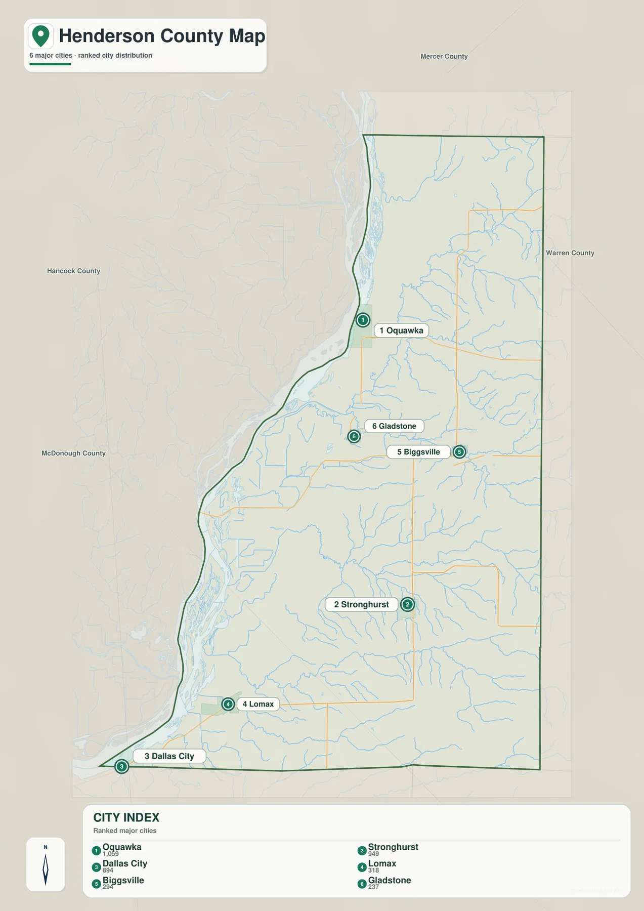
The city map narrows attention to six labeled communities and assigns each one a rank. Oquawka is first with an index value of 1,059, Stronghurst is second at 949, and Dallas City is third at 894. Lomax follows at 318, Biggsville at 294, and Gladstone at 237. These figures are the values printed on the supplied CITY INDEX. They are useful for explaining the ranking on this map, but they should not be presented as the latest official Census population counts.
The spatial pattern matters as much as the rank. Oquawka anchors the northwestern river side, with Gladstone south of it. Biggsville lies inland in the north-central portion of the county, while Stronghurst sits farther south near Route 94. Lomax and Dallas City occupy the southwestern end of the map. Looking at those positions together makes it clear that the selected communities are spread through several parts of the county rather than clustered around one large urban center.
Neighboring county labels help with orientation as well. Mercer County is shown to the north, Warren County to the east, and Hancock and McDonough counties appear along the western and southwestern surroundings. For classroom or regional comparison work, the ranked-city view works best beside the general road map: the city layer simplifies the settlement pattern, while the road map restores the routes and many additional place names.
Henderson Creek, floodplain lakes, and the western water corridor
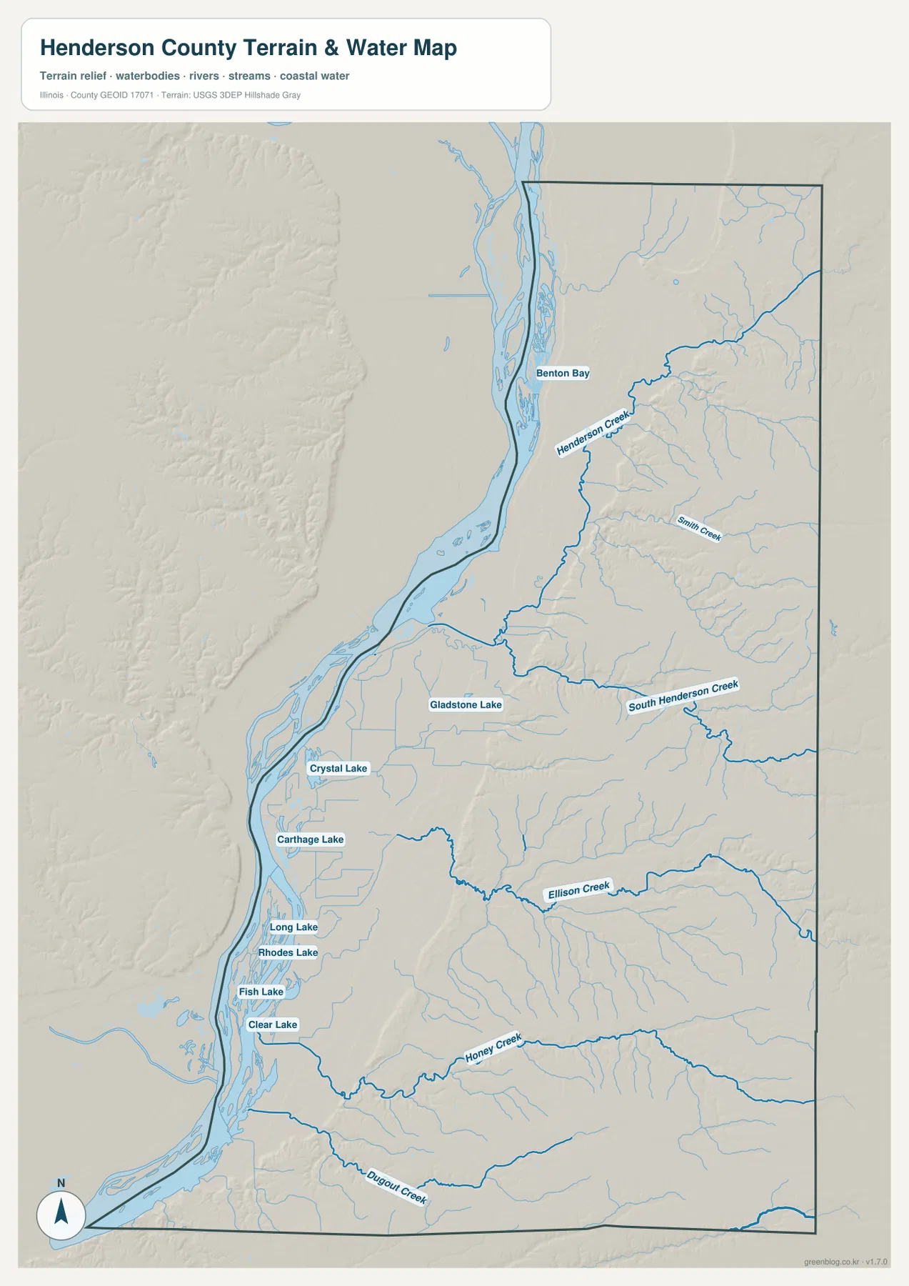
The terrain-and-water map adds a different set of landmarks. Henderson Creek is prominent in the north and bends westward toward the large river corridor. Smith Creek and South Henderson Creek appear farther south, while Ellison Creek, Honey Creek, and Dugout Creek cut across the central and southern interior. Many smaller tributaries branch from these named creeks, revealing a much denser drainage pattern than the simplified blue lines on the general map.
A chain of named water bodies occupies the western lowlands. Benton Bay is labeled near the north, Gladstone Lake sits farther south, and Crystal Lake and Carthage Lake appear in the central-western floodplain. Long Lake, Rhodes Lake, Fish Lake, and Clear Lake continue the sequence toward the south. The concentration of lakes close to the river contrasts with the creek valleys that extend through the eastern uplands.
This map is intended for geographic reference, not for hazard or access decisions. It does not show flood probabilities, levee condition, water depth, navigability, public boat access, or parcel ownership. A blue channel or lake label confirms a mapped water feature, but it does not tell the reader whether nearby land is flooded at a particular time. For safety, insurance, or property questions, current agency data should be consulted separately.
From 148-meter lowlands to 243-meter eastern high ground
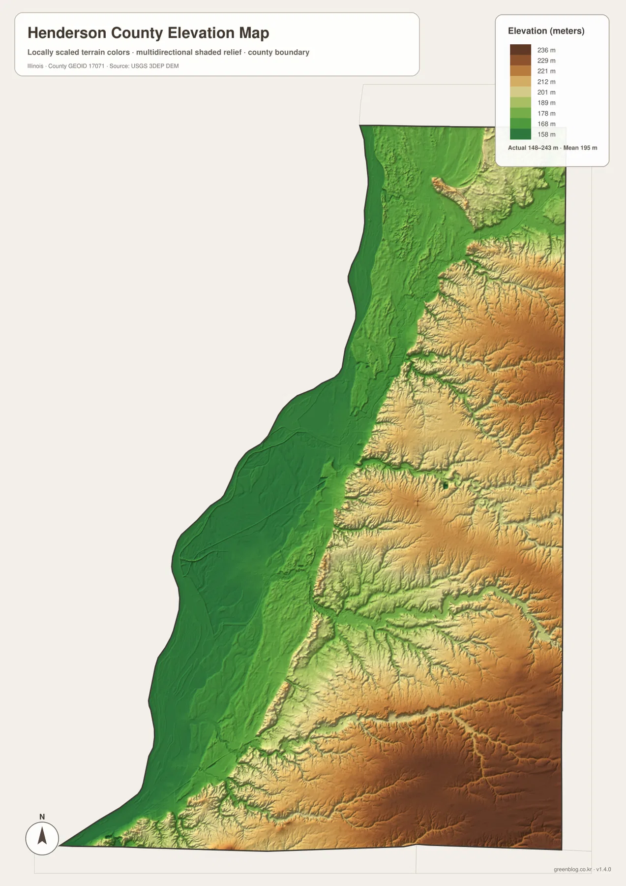
The elevation map reports an actual county range of about 148 to 243 meters and a mean near 195 meters. The lowest green tones form a long band along the western river side. Moving east, the surface shifts through lighter green and tan into higher ground, and narrow lower corridors cut back into the uplands along the creek valleys. The result is not a simple west-to-east slope; it is a broad low plain beside the river followed by increasingly dissected terrain inland.
The northeast and east contain repeated ridges and small valleys, while the southeastern interior also reaches some of the higher colors on the map. The contrast is strongest when the elevation map is compared directly with the water map: the creek courses occupy lower grooves, and the higher ground sits between them. That pairing helps explain why the interior can appear relatively flat on a road-only map even though the shaded relief reveals numerous changes in local height.
These elevation values are suitable for county-scale comparison, not survey work. The color surface generalizes terrain and does not guarantee the exact height of a parcel, road centerline, building site, or field corner. Engineering design, drainage calculations, construction staking, and legal surveying require original elevation data and professional measurements. USGS 3DEP is the appropriate starting point when more precise elevation information is needed.
How roads, water, and relief change the view of the county
A road-only reading emphasizes Route 164 from Oquawka, Route 34 toward Biggsville, and Route 94 through the Stronghurst area. Once the water layer is considered, those same roads sit among Henderson Creek, South Henderson Creek, and many smaller tributaries. The eastern half therefore becomes easier to understand as a landscape of ridges and creek valleys rather than a uniform block of farmland and straight roads.
The western side tells a different story. Fewer interior road lines compete with the large river corridor, floodplain lakes, and broad low elevation band. Following Oquawka, Gladstone, Gulfport, Carman, and Lomax from north to south makes that lowland continuity clear. Moving east toward Biggsville, Stronghurst, Media, and Raritan brings more creek-cut terrain and higher ground into the picture.
Big River State Forest provides useful real-world context for the western part of Henderson County. The Illinois Department of Natural Resources describes it as a state forest north of Oquawka with long-standing forestry demonstrations and an older pine plantation. The article maps are not recreation maps and do not show every facility in the forest, but the official IDNR page helps connect the county’s river-side setting with an actual protected landscape in the area.
Choosing the right Henderson County file
For general orientation, start with the county map and locate Oquawka, Biggsville, and Stronghurst before tracing Routes 164, 34, and 94. Use the ranked-city map when the task is to compare the six selected communities without the clutter of every road and settlement label. The terrain-and-water map is the better choice for Henderson Creek, South Henderson Creek, the western lakes, and other hydrologic features. The elevation view is the clearest file for comparing the low river corridor with the higher eastern interior.
The browser previews are convenient for quick reading, but small stream labels and road numbers are easier to inspect in the downloadable originals. Each JPG is 2572 × 3638 pixels, which gives substantially more room for enlargement and printing than the WebP preview shown in the article. They can be used in classroom handouts, presentations, regional comparison sheets, or personal reference notes as long as the map’s limitations are respected.
None of the files should replace an authoritative parcel map, legal boundary survey, flood study, navigation chart, or engineering-grade elevation product. The purpose here is geographic reference: locating communities, comparing road directions, following named water features, and seeing broad changes in relief. When an exact boundary, current demographic number, flood condition, or site elevation matters, the linked Census and USGS sources provide the appropriate next step.
Download the original Henderson County JPG files
The ZIP below contains the original JPG versions of the four map views used in this article. They are easier to enlarge than the browser previews and preserve small labels for printing or close inspection. Keep the original aspect ratio when resizing so that the county shape, road network, and relief surface are not distorted.
Frequently Asked Questions
Are the CITY INDEX numbers current population estimates?
No. The values are the numbers printed on the supplied ranked-city map and are used here only to explain that map. Oquawka is shown at 1,059, Stronghurst at 949, and Dallas City at 894, followed by Lomax, Biggsville, and Gladstone. Use current U.S. Census data when an up-to-date official population figure is required.
Can the terrain-and-water map be used to judge flood risk?
No. It shows the relative locations of creeks, lakes, the western river corridor, and surrounding terrain, but it does not contain flood probabilities, water levels, levee condition, or emergency guidance. Current flood and river information should be checked separately before making safety, insurance, or property decisions.
Is the 148–243 meter elevation map suitable for surveying?
No. The elevation surface is meant for broad county comparison and is not survey grade. It shows the lower western corridor and higher eastern ground clearly, but it does not provide certified spot elevations or engineering tolerances. Use original USGS 3DEP data and professional surveying for precise site work.
Map File Information
The ZIP contains the Henderson County general map, ranked city map, terrain-and-water map, and elevation map as high-resolution JPG files.
- Included Files: 4 JPG maps
- Printable Size: 2572 × 3638 pixels each
- Intended Use: Printing, education, presentations, and geographic reference
Related Maps
Sources and references
- Illinois DNR – Big River State Forest: official information about the state forest in Henderson County and its location north of Oquawka
- U.S. Census Bureau QuickFacts – Henderson County, Illinois: current official county demographic statistics for checks beyond the supplied CITY INDEX
- U.S. Census Bureau TIGER/Line Shapefiles: authoritative boundary and geographic reference data
- USGS National Hydrography: national source data for rivers, streams, and water features
- USGS 3D Elevation Program: source information for higher-precision elevation data
Green Map creates custom-edited map images using open geographic data sources such as geoBoundaries, Natural Earth, OpenStreetMap, and government open data.
These maps are edited visual materials, not raw data files, and are provided for education, documents, presentations, and graphic reference.