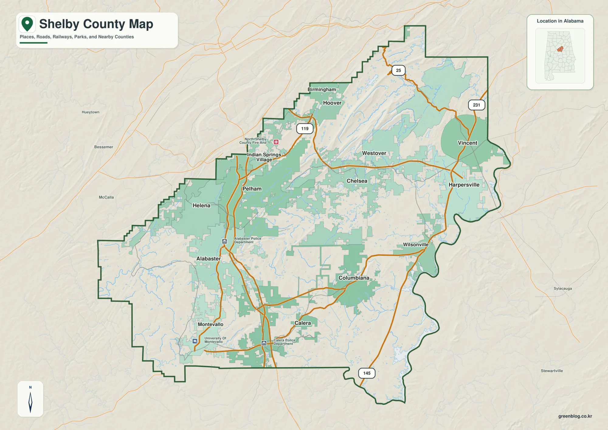
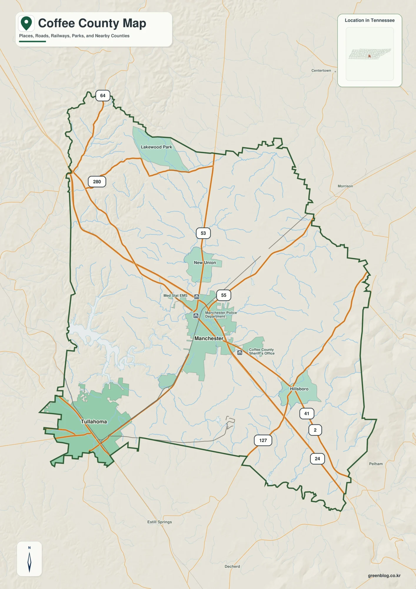
Ford County has an outline that is easy to recognize once you see it on a map. A long, narrow northern section extends past Piper City toward Kempton, while the county broadens sharply in the south around Paxton, Gibson City, Sibley, and Melvin. This page brings the boundary, numbered roads, settlement locations, named waterways, and elevation into one county guide. The map files can also be downloaded below as high-resolution JPG originals in a ZIP archive, which is useful when the browser previews are too small for road numbers, creek names, or printing.
Paxton is the county seat in the southeastern part of Ford County, and the general map marks the Ford County Courthouse. Gibson City sits near the southwestern edge, Piper City is much farther north, and Roberts and Melvin occupy the transition between the narrow upper section and the wider lower section. Sibley lies to the west within the broader southern block. Labels around the county also help place Ford County among Kankakee, Iroquois, Vermilion, Champaign, McLean, and Livingston counties. The official Ford County government site notes that the county was established on February 17, 1859, and was the 102nd and last county created in Illinois.
The supplied maps are designed for different kinds of questions. The general county map is the best starting point for roads, county shape, and place names. The city map gives a cleaner comparison of six ranked settlements. The terrain-and-water map highlights the North Fork Vermilion River, Mackinaw River, creeks, ponds, and named drainage ditches that are easy to miss on the road map. The elevation view shows an actual range of roughly 198 to 265 meters, with a lower north-central corridor and stronger higher ground in the southwest. Using the views together makes the county’s prairie geography much easier to understand than relying on a single image.
Table of Contents
From the Narrow Northern Strip to the Paxton–Gibson City Road Network
The county boundary is not a simple rectangle. The northern arm stays narrow from the top of the county through the Piper City area and continues south toward Roberts. Near Roberts and Melvin, the boundary steps west and opens into a much broader southern section containing Sibley and Gibson City. The southeastern portion then extends east around Paxton. That changing width is important when reading the map because towns that appear fairly close in north-south position can sit in very different east-west parts of the county.
Several numbered roads provide clear orientation. Route 24 crosses the narrow northern section through Piper City, and Route 116 runs east-west farther north. Route 115 forms a useful north-south reference from the Roberts area toward Paxton. Across the broad southern part of the county, Route 9 connects the Gibson City side with Paxton. Routes 47 and 54 are visible around Gibson City, while Routes 45 and 57 appear around Paxton. The result is a denser road pattern in the south, where the county is wider and the two largest mapped settlements are located.
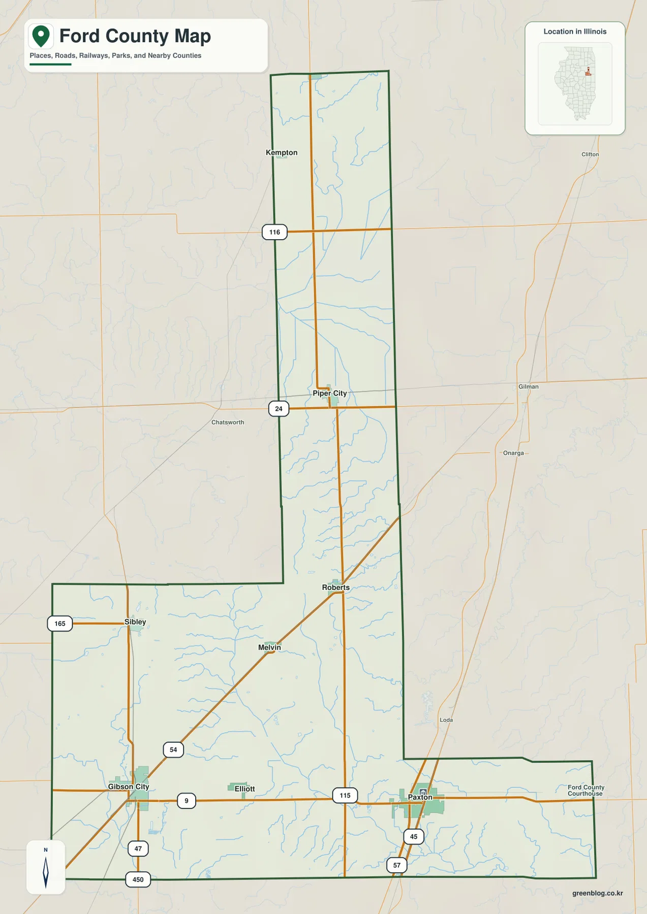
Settlement positions make more sense after the boundary and roads are familiar. Paxton sits in the southeast and serves as the county-government reference point. Gibson City is near the southwest edge, which places it closer to the Champaign and McLean county sides of the map. Piper City lies much farther north inside the narrow section, while Roberts and Melvin sit around the point where the county begins to widen. Sibley is separated to the west in the broad lower block. These locations provide a useful framework for the city and water maps because those views remove some labels and emphasize different features.
Two Southern Centers and a Chain of Smaller Settlements to the North
The city map reduces road detail and highlights six settlements with values from the supplied city index. Paxton ranks first at 4,131 and Gibson City second at 3,343. Piper City follows at 703, Roberts at 487, Melvin at 430, and Sibley at 286. These figures belong to the map’s ranked-city dataset and should not be treated as a current population estimate for the county. Their purpose here is comparative: they show which mapped settlements are larger within this particular index and where those places sit inside Ford County.
The two strongest settlement anchors are separated across the broad southern part of the county. Paxton is on the southeastern side and Gibson City on the southwestern side. Roberts and Melvin occupy intermediate positions, Piper City extends the settlement chain far into the narrow north, and Sibley sits west of the central north-south line. U.S. Census Bureau QuickFacts reports about 485.6 square miles of land area and a 2020 population of 13,534 for Ford County. Seen against that county size, the city map presents a dispersed rural pattern rather than a single continuous urban area.
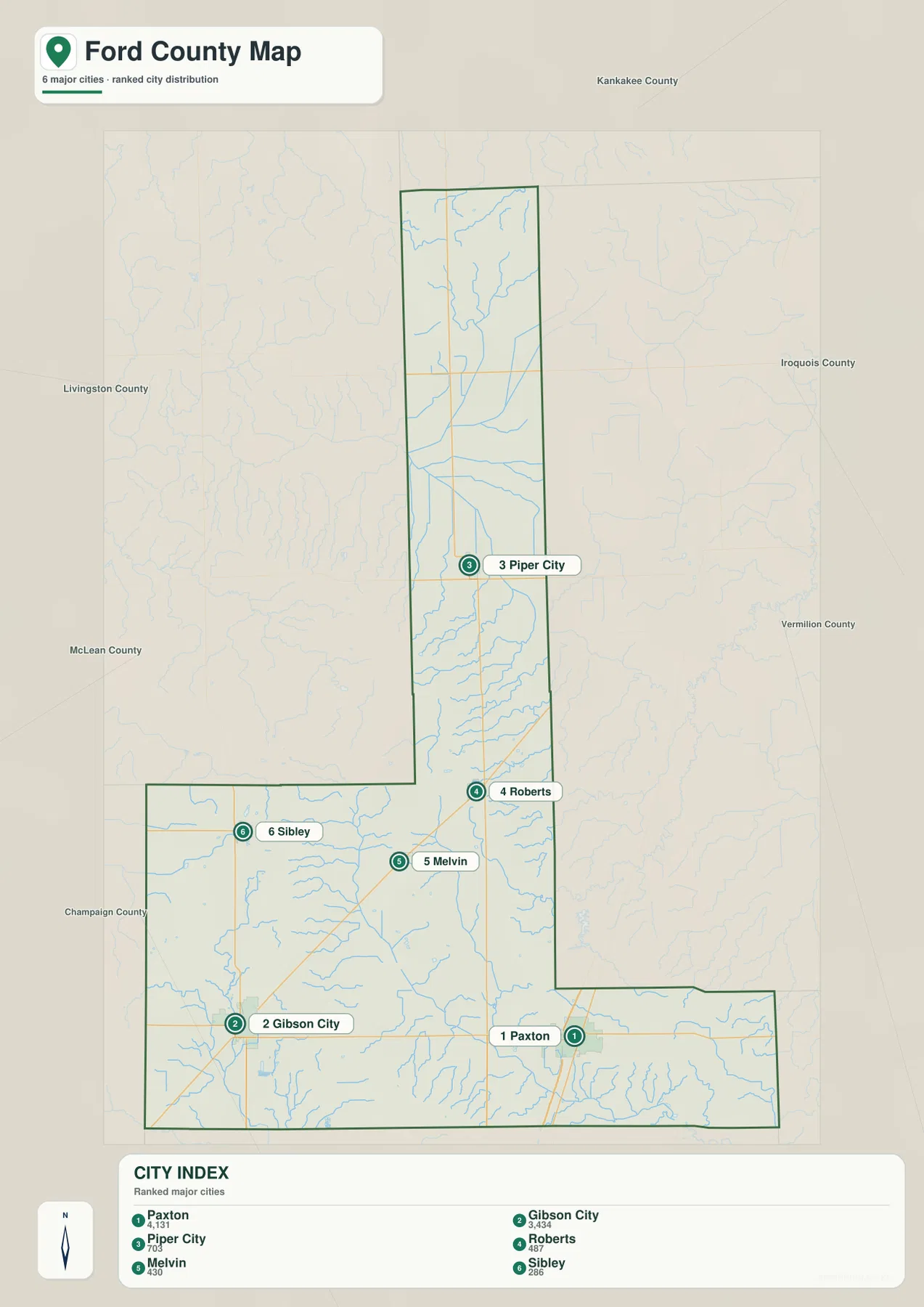
This map is better for relative position than for travel planning. A trip from Paxton to Piper City, for example, should be planned with the general road map and current transportation information rather than by measuring the straight-line spacing on the city layer. For a classroom handout, county profile, or regional comparison, however, the simplified view is useful because it makes the southern concentration and the northward extension of smaller settlements easy to see without many competing labels.
North Fork Vermilion, Mackinaw River, and the Prairie Drainage Network
Water in Ford County appears mainly as rivers, creeks, branches, and drainage ditches rather than large lakes. In the narrow northern section, Kelly Creek is labeled above the North Fork Vermilion River. The North Fork bends through the north-central county and becomes one of the strongest natural reference features on the map. Numerous smaller tributaries enter from different directions, so the water layer looks much more intricate than the relatively straight road network shown on the general map.
The southwest has a different collection of named features. Mackinaw River and Drummer Creek are prominent near the western side, and Lake Sibley and Storm Water Pond are also labeled. Blackford Slough follows the southern area, while the central and southeastern parts of the county include Wall Town Drainage Ditch, Ford Special Drainage Ditch, and The Big Four Ditch. Sugar Creek stands out near the southeastern edge, and Bayless Lake appears just outside the eastern county line as a useful nearby reference. The combination of streams and ditches reflects both natural drainage and the managed water network of an agricultural county.
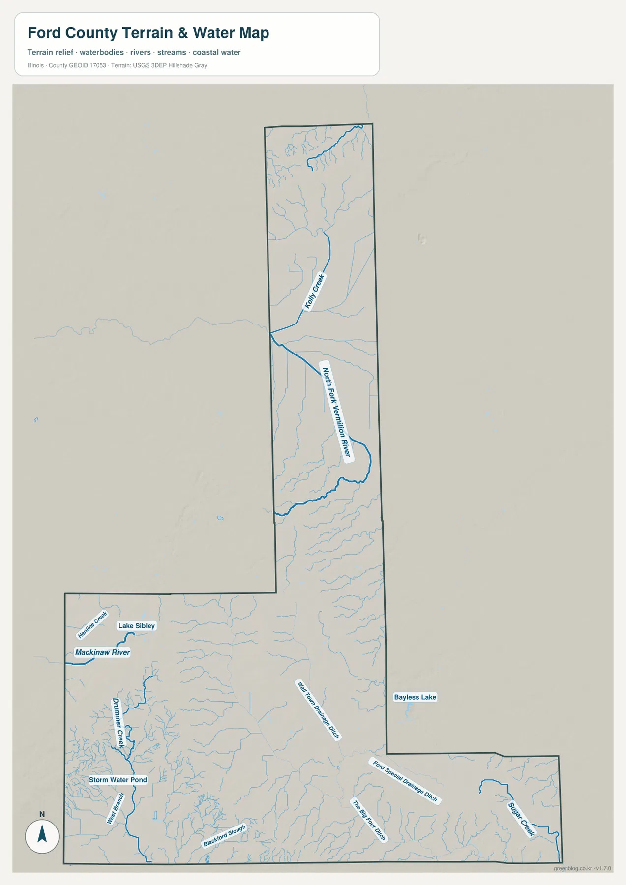
Comparing the water and settlement maps gives each part of the county a clearer identity. Piper City and Roberts are closest to the North Fork Vermilion system, while Gibson City and Sibley are associated more closely with the Mackinaw River and Drummer Creek side of the county. Paxton is surrounded by southeastern drainage features including Sugar Creek and named ditches. The map should not be used as a flood-hazard, navigation, water-quality, or legal-access map. It is a location reference, and current agency information should be consulted for safety, property, or regulatory decisions.
Subtle Prairie Relief from About 198 to 265 Meters
The elevation map reports an actual county range of about 198 to 265 meters and a mean near 228 meters. The difference is modest compared with a hill or mountain county, but the color ramp still reveals clear local variation. Much of the long north-central section is dark green, indicating lower terrain within the county’s own range. In contrast, the broad southwest contains more yellow, tan, and brown, especially west and southwest of Gibson City. Smaller patches of higher ground also appear near the far north and along parts of the southern edge.
The southwest is the easiest place to see the contrast because darker brown bands occupy portions of the broad western block, while the central corridor north of Roberts is predominantly green. Paxton does not sit inside the darkest high-relief area; instead, the southeast mixes greens with lighter yellow-green and tan shades. The map therefore shows a county that is broadly flat but not perfectly level. Small changes in height repeat across the prairie and become easier to notice when the county is displayed with a locally scaled elevation palette.
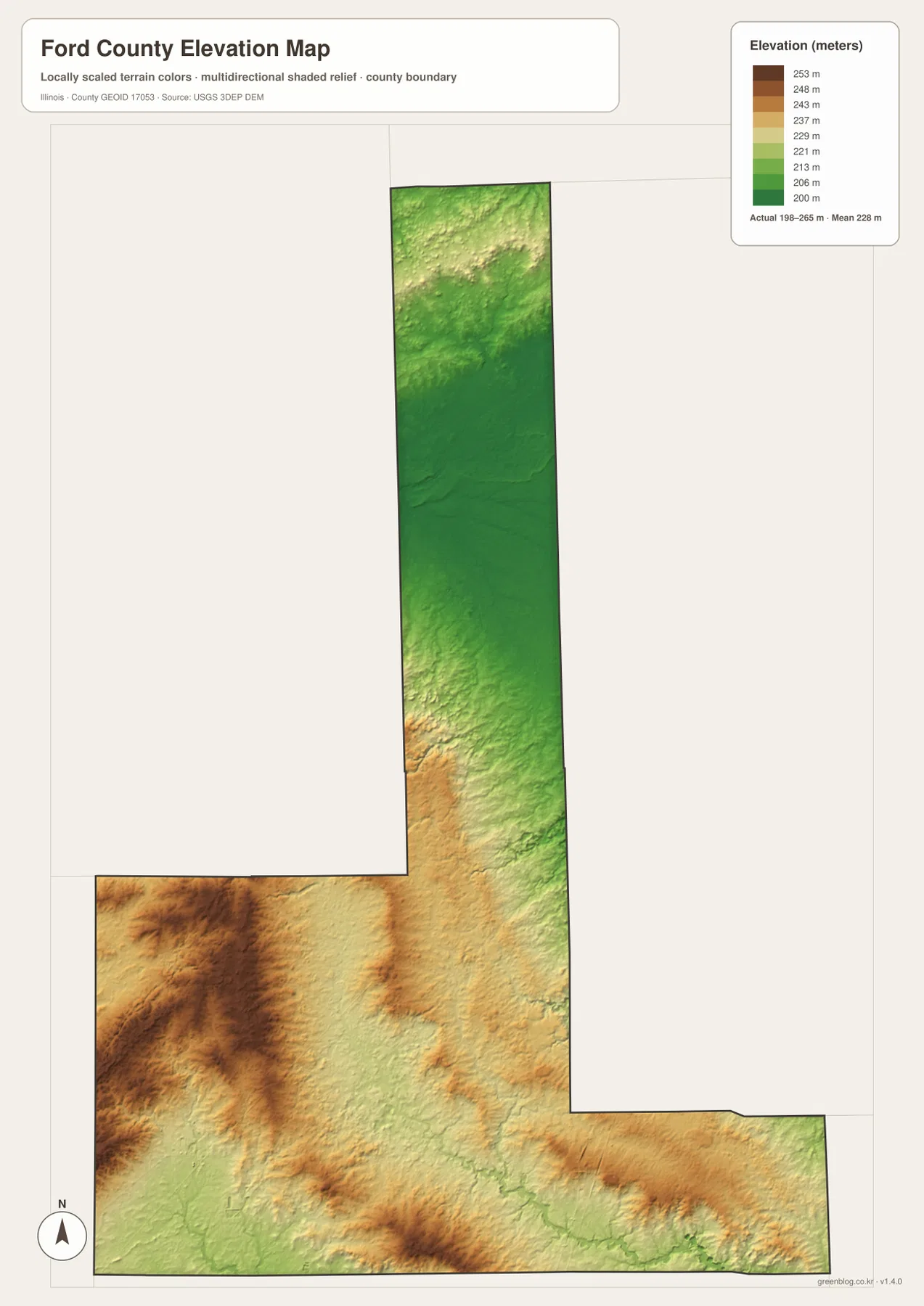
The water map becomes more useful when placed beside the elevation view. Several sections of the North Fork Vermilion River occupy lower green terrain, and parts of the southwestern drainage network follow lower areas between higher patches. That comparison is appropriate at county scale, but the image is not a survey product. It should not be used to set a building elevation, road grade, property drainage plan, or legal benchmark. Those tasks require original USGS elevation data and site-specific professional measurements.
Choosing the Right Ford County File and Using the Full-Resolution JPGs
For a first pass through Ford County, the general map is the most useful place to start. Locate Paxton, Gibson City, and Piper City, then use Routes 9, 24, 54, and 115 to understand the main directions. Move to the city map when the question is how the six highlighted settlements are distributed. Use the water map when the North Fork Vermilion River, Mackinaw River, Kelly Creek, Sugar Creek, or drainage ditches are the main subject. The elevation map is best when the goal is to compare the lower north-central corridor with the higher southwest.
A place-based comparison can begin with any of the major settlements. Around Paxton, the general map supplies courthouse and highway context, while the water map adds southeastern creeks and ditches and the elevation map shows the surrounding low-to-moderate relief. Around Gibson City, Routes 9, 47, and 54 are the clearest road references, and the higher terrain to the west and southwest stands out on the elevation view. Farther north, Piper City is easy to locate with Route 24, after which the North Fork Vermilion River becomes the dominant natural feature on the water map.
The WebP maps embedded in the article are reduced previews for fast browser viewing. The downloadable archive contains the general county, city, water, and elevation maps as original 2572 × 3638 pixel portrait JPG files. Those larger images are better for enlarging small labels, printing a classroom sheet, preparing a local-history presentation, or comparing Ford County with neighboring counties at a similar scale. Keep the original aspect ratio when resizing, and make a proof print when fine road or water labels need to remain readable.
Frequently Asked Questions
Which map is best for comparing Paxton and Gibson City with their roads?
The general county map is the best single view because it combines both settlement positions with numbered roads. Paxton appears near Routes 9, 45, and 57, while Gibson City is near Routes 9, 47, and 54. The city map is useful as a second view when you want a cleaner comparison of the six highlighted settlements without as many road labels.
What is the easiest water feature to identify in northern Ford County?
The North Fork Vermilion River is the most prominent labeled river in the northern and north-central part of the county, with Kelly Creek farther north. In the southwest, Mackinaw River and Drummer Creek become stronger references, while Sugar Creek and several named drainage ditches are easier to find around the southeastern part of the county.
Can the 198–265 meter elevation map be used for surveying or construction?
No. The map is intended for broad county-level comparison, such as recognizing the lower north-central area and the higher southwest. It is not accurate enough to establish site grades, building elevations, drainage design values, or legal survey points. Use original USGS 3DEP data and professional site measurements when exact elevation is required.
Map File Information
Download the Ford County general, city, water, and elevation maps together as high-resolution A3-format JPG originals.
- Included Files: County, city, water, and elevation maps
- Printable Size: 2572 × 3638 pixels each
Related Maps
Sources and Reference Data
- Ford County, Illinois – Official County Government – county government, courthouse location, and county history
- U.S. Census Bureau QuickFacts – Ford County, Illinois – county population and land-area reference
- Illinois Department of Transportation – Highway Maps – official Illinois road and highway map resources
- USGS National Hydrography – hydrography and water-feature reference
- USGS 3D Elevation Program – elevation data and terrain reference
Green Map creates custom-edited map images using open geographic data sources such as geoBoundaries, Natural Earth, OpenStreetMap, and government open data.
These maps are edited visual materials, not raw data files, and are provided for education, documents, presentations, and graphic reference.