Edgar County lies along the Indiana border in east-central Illinois, and Paris is the easiest place to use as a starting point. The county seat and largest city marker sits in the southeastern half, while Chrisman is well to the north, Hume and Brocton line the western side, Kansas reaches into the southwest, and Vermilion lies east of Paris. The roads look fairly orderly at first, but the terrain changes once the dense creek network is added. High-resolution JPG originals of the supplied maps are bundled in one ZIP download for enlargement, printing, classroom work, or presentations.
Edgar County has two especially useful natural references. Brouilletts Creek and its tributaries occupy much of the eastern half, creating a closely branched set of low valleys. North Fork Embarras River appears in the southwest and belongs to a different drainage direction. The elevation image reinforces that division: higher ground is strongest along the northern edge and in the southwest, while much of the east is lower and more deeply cut by streams.
Illinois State Archives records Edgar County as established on January 3, 1823 and lists Paris as the county seat from 1823 to the present. Edgar County’s hazard-mitigation plan also describes the county as gently rolling with broad floodplains and stream terraces along major waterways. Those official descriptions match the supplied maps, where Paris anchors the road network and river valleys strongly shape the eastern and southwestern terrain.
Table of Contents
Paris organizes the southern road network
Paris occupies the clearest road junction in the southern-eastern county. U.S. 150 runs north from the Paris area toward Chrisman, while Illinois Route 1 continues south to the county boundary. Route 133 approaches Paris from the west, and the road marked 900 continues toward Vermilion and the Indiana side. The combination makes Paris easy to relocate on every map view.
The northern county has a different pattern. U.S. 36 crosses from Hume through Metcalf and Chrisman, tying the northern towns together on a nearly straight east-west line. Route 49 forms the main western north-south reference through the Brocton side and continues toward Kansas. Around Kansas, additional labels such as 16, 600, and 125 show the smaller connections that feed into the western edge.
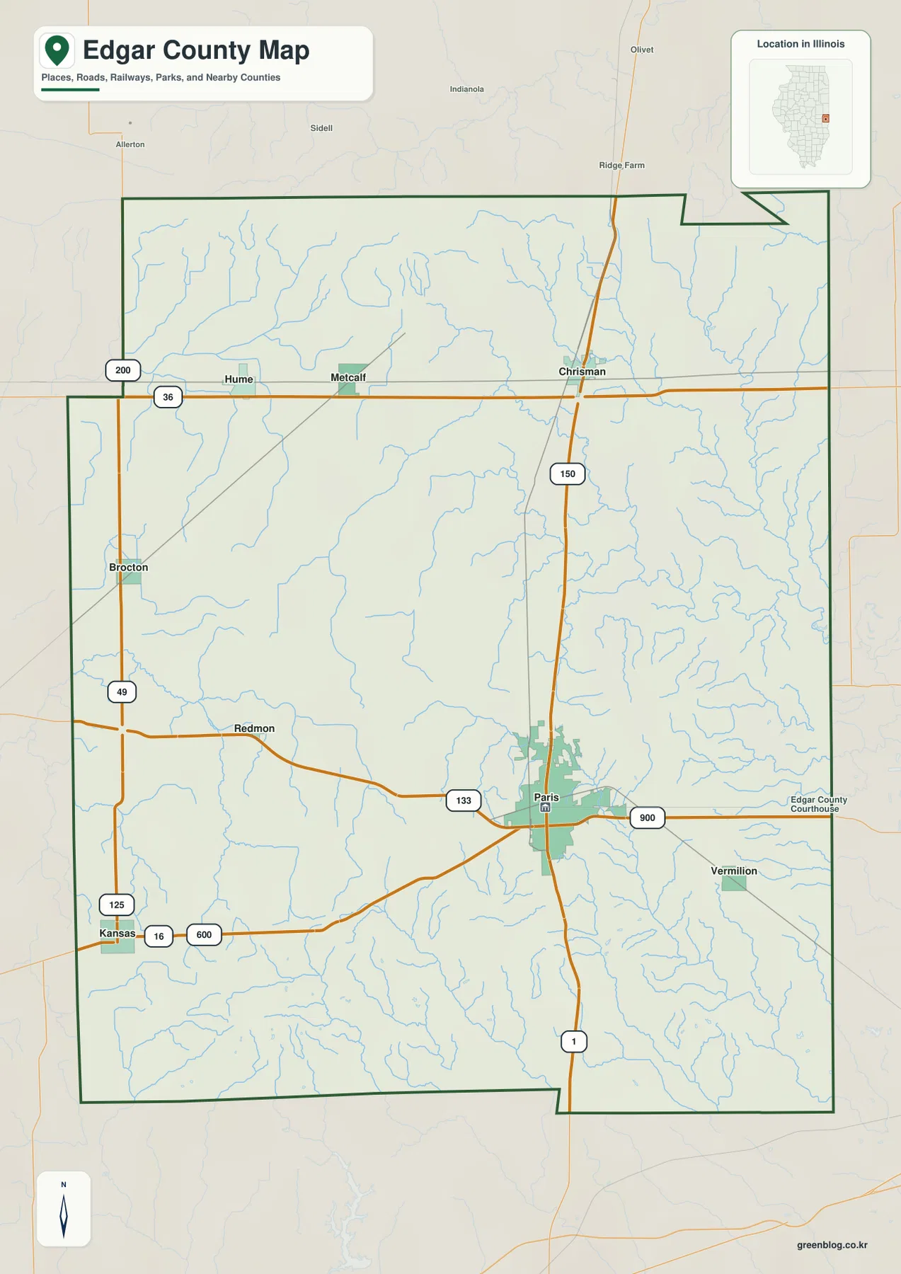
The Edgar County Courthouse is labeled east of central Paris, and railways with several roads reinforce the city’s role as the main mapped center. Chrisman is the second major junction, where U.S. 36 and U.S. 150 meet. Hume, Brocton, and Kansas define the western side at different latitudes. Remembering Paris and Chrisman as the eastern pair, then adding the three western towns, makes the county easier to navigate before the dense stream layer is considered.
Paris has been the county seat since 1823
Illinois State Archives lists Paris as Edgar County’s seat continuously from the county’s creation in 1823 to the present. The current Edgar County Courthouse is also in Paris. Because Paris is both the administrative center and the largest city marker on the supplied maps, it is the most stable reference point for the county.
Paris and Chrisman set the scale of the city map
The simplified city graphic gives Paris the largest marker and Chrisman the second-largest. Kansas is ranked third, Hume fourth, Brocton fifth, and Vermilion sixth. Its printed CITY INDEX lists 8,276 for Paris, 1,214 for Chrisman, 884 for Kansas, 492 for Hume, 275 for Brocton, and 219 for Vermilion.
The graphic does not show a census year or statistical reference date, so this article does not treat those figures as current population counts. The geographic arrangement is more useful: Paris sits in the southeastern half, Chrisman is far north, Hume and Brocton occupy the west, Kansas reaches the southwest, and Vermilion lies just east of Paris near the Indiana side.
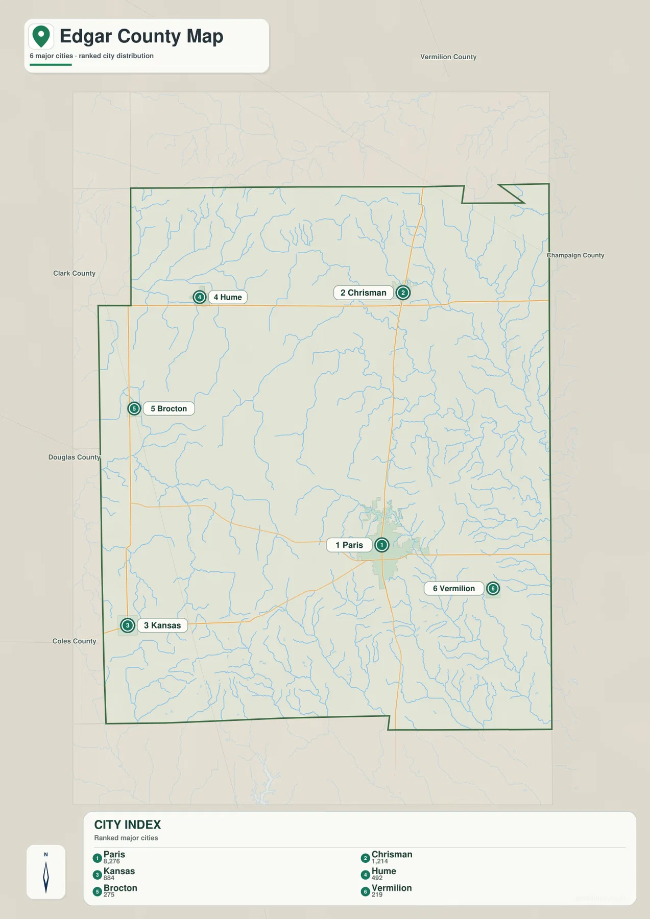
The simplified layout makes the long north-south spacing obvious. Paris and Chrisman are both on the eastern half but are separated by a substantial distance. Hume and Brocton create a western pair, with Kansas farther south. Vermilion gives the Paris area an additional eastern marker. Once those six locations are familiar, the detailed road and water maps are easier to read without losing orientation.
The CITY INDEX is undated map data
Use a source with a stated reference year, such as the U.S. Census Bureau, when current population is required. The supplied CITY INDEX does not identify its date, so the figures on this page are used only to describe the marker ranking and relative emphasis shown by the map.
Brouilletts Creek dominates the east while Embarras water drains the southwest
The eastern half of the terrain-and-water map contains the most complex drainage. Brouilletts Creek and Crabapple Creek collect many short tributaries north and east of the Paris area, while the North Fork Brouilletts system occupies another long low corridor nearby. The density of these channels makes the Chrisman-to-Paris side look far more dissected than the broad western interior.
Farther south, Sugar Creek forms a major southeastern channel, with Clear Creek and Big Creek among the smaller named tributaries nearby. The southwest is different: North Fork Embarras River runs along the lower edge and creates a separate broad low route. Catfish Creek and Hickory Grove Creek occupy the west-central county, and Simonson Branch with Baney Fork adds smaller drainage in the northwest.
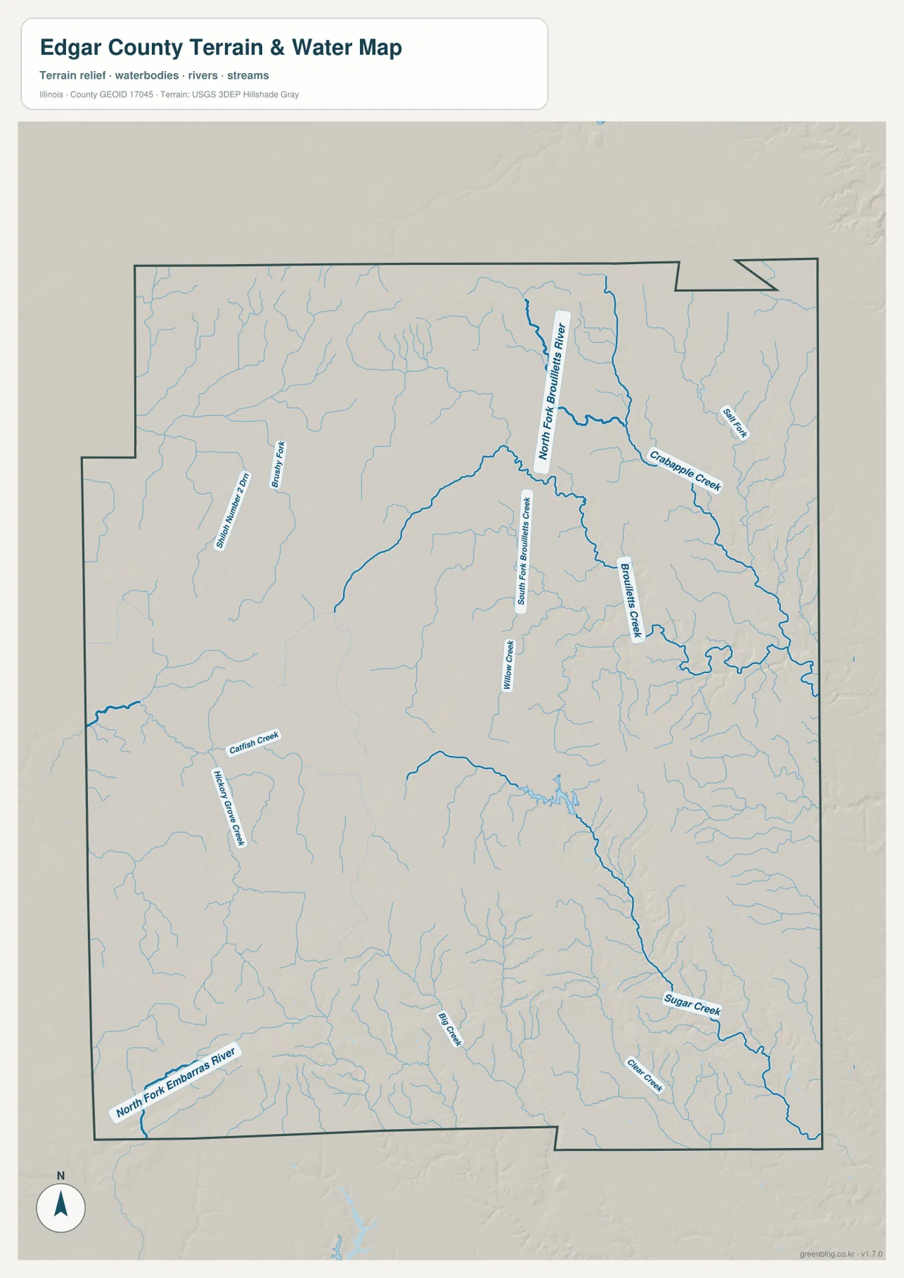
Edgar County’s hazard-mitigation plan describes the county as gently rolling, with broad floodplains and stream terraces beside its major waterways. It also places the western part of the county in the Embarras River watershed and the eastern part in the Wabash River Valley watershed. That county-level description fits the supplied map well: the southwestern Embarras drainage and the tightly branched eastern creek system belong to different large drainage directions.
The water map is not a live flood map
The terrain sheet is intended to show the locations of rivers, creeks, and surrounding relief. It does not provide current stage, flood-hazard boundaries, water depth, or access conditions for Brouilletts Creek or North Fork Embarras River. For present-day flood or safety decisions, use current Edgar County emergency-management and USGS information.
Higher north and southwest ground stands above the eastern creek valleys
The elevation image shows a long band of higher brown and orange terrain across the northern edge, with another broad high area in the southwest and south-central county. The eastern half is much greener and lower. Brouilletts Creek, Crabapple Creek, and Sugar Creek cut narrow low valleys into that eastern terrain, creating the strongest concentration of relief lines on the map.
The map reports an actual countywide elevation range of about 154 to 254 meters and a mean near 203 meters. Its color legend uses narrower bands from roughly 176 to 228 meters, while the separate “Actual” line records the wider minimum and maximum of the dataset. Those endpoints describe Edgar County as a whole and should not be assigned directly to Paris, Vermilion, Hume, or another named place.
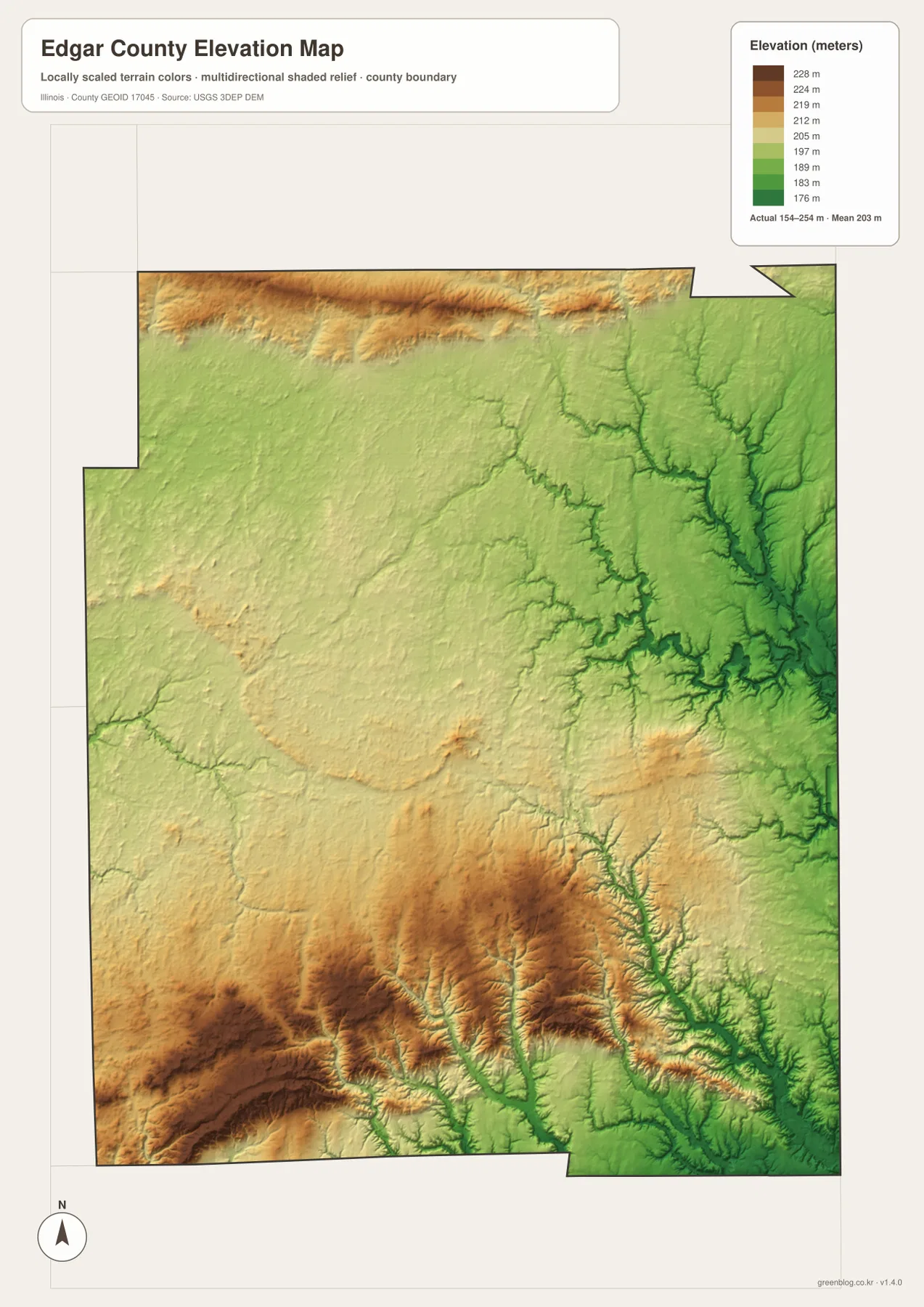
Comparing the elevation and water maps makes the low corridors much easier to identify. Brouilletts Creek, Crabapple Creek, and Sugar Creek occupy greener terrain in the east, while North Fork Embarras River cuts through the higher southwestern country. Smaller tributaries also notch the northern upland. The road map alone hides much of this contrast because its long straight routes cross the terrain without following the stream valleys.
154 to 254 meters is a countywide range
A building site, road grade, drainage plan, or parcel needs point-specific elevation data or a professional survey. The 154–254 meter range is most useful for comparing higher and lower parts of Edgar County, not for assigning an exact elevation to Paris or any other town or address.
Keep Paris fixed while switching between roads, water, and relief
A practical way to use the files is to keep Paris fixed as the anchor. On the overview, add Chrisman to the north, then Hume, Brocton, and Kansas along the western side and Vermilion to the east. The city map simplifies those same relationships and makes the spacing between the six selected places easier to remember.
Next, switch to the water map and follow the Brouilletts Creek network through the eastern half, then compare it with North Fork Embarras River in the southwest. The elevation map completes the picture by showing lower eastern valleys below the higher northern and southwestern ground. Using the same landmarks across the files keeps towns, roads, drainage, and relief connected.
For trip planning, current road information should take priority; population work should use dated Census releases, while river or flood questions and exact elevations require the latest agency or point-level data. Within those limits, the Edgar County maps are useful for printed references, lessons, presentations, and advance geographic orientation.
Frequently Asked Questions
What is the county seat of Edgar County, Illinois?
Paris is the county seat. Illinois State Archives records Paris in that role continuously from Edgar County’s establishment in 1823 to the present, and the current Edgar County Courthouse is also in Paris.
How is Edgar County’s drainage divided?
The supplied map shows North Fork Embarras River in the southwest and the Brouilletts, Crabapple, and Sugar creek system in the east. Edgar County’s hazard plan describes the western portion as part of the Embarras River watershed and the eastern portion as part of the Wabash River Valley watershed.
Does 154 to 254 meters give Paris’s elevation?
No. The elevation image identifies 154–254 m as the actual range across the Edgar County dataset and gives a mean of about 203 m. Exact elevation for Paris or any specific road, building, or property requires point-specific elevation or survey data.
Sources and Reference Material
The article uses the supplied Edgar County maps together with the official references below. For current roads, river stages, flood conditions, legal boundaries, or exact point elevations, consult the responsible agency’s latest material rather than relying on a static county reference map.
- Edgar County Official Website – current county government and Paris administrative information
- Illinois State Archives – Edgar County – 1823 establishment, name origin, and Paris county-seat history
- Edgar County Multi-Jurisdictional Hazard Mitigation Plan – county location, terrain, floodplains, and Embarras/Wabash watershed context
- USGS National Hydrography – river and stream reference data
- USGS 3D Elevation Program – elevation and terrain data
Map File Information
The ZIP file contains the high-resolution JPG originals for the Edgar County overview, city map, terrain-and-water map, and elevation map. Each portrait JPG is 2,572 × 3,638 pixels, so Edgar County town names, route labels, creek names, and the relief shading remain easier to read at larger viewing or print sizes.
- Included Files: 4 high-resolution JPG maps
- Printable Size: 2,572 × 3,638 pixels each
Related Maps
Green Map creates custom-edited map images using open geographic data sources such as geoBoundaries, Natural Earth, OpenStreetMap, and government open data.
These maps are edited visual materials, not raw data files, and are provided for education, documents, presentations, and graphic reference.