De Witt County in central Illinois is easiest to understand by starting at Clinton. The county seat sits slightly west of the middle, with Farmer City far to the northeast, Wapella to the north, Waynesville in the northwest, Kenney to the southwest, and Weldon in the southeast. The towns are spread in several directions rather than clustered tightly together, and a dense network of creeks fills the space between them.
The supplied maps connect that settlement pattern to roads, Lake Clinton, and countywide relief. The overview uses Clinton as the road reference, the city graphic compares six selected places, the terrain sheet follows Salt Creek and the branches around Lake Clinton, and the elevation image shows high north-central ground above the lower lake and creek corridors. High-resolution JPG originals are included in one ZIP download for enlargement, printing, classroom material, or presentation use.
Illinois State Archives records show that DeWitt County was established on March 1, 1839 and that Clinton has served as the county seat from the beginning to the present. The current DeWitt County Courthouse is also in Clinton. That unusually consistent county-seat history makes Clinton a particularly useful reference when moving between the road, city, water, and elevation maps.
Table of Contents
Clinton organizes the road network
Route 54 is the clearest east-west line on the county overview. It passes through Clinton and continues northeast toward Farmer City, while extending west to the county boundary in the opposite direction. Route 51 crosses Clinton from north to south. Near Farmer City, roads marked 74 and 150 provide additional regional connections, making the northeastern corner one of the strongest highway entry points on the map.
Waynesville sits near the northwestern edge, and Kenney lies southwest of Clinton along a diagonal road. De Witt and Lane appear east of the county seat, while Weldon is farther southeast. The DeWitt County EMS label near Clinton adds another local reference around the central road junction. The road structure is relatively easy to follow, but the blue tributaries create a much less regular pattern beneath it.
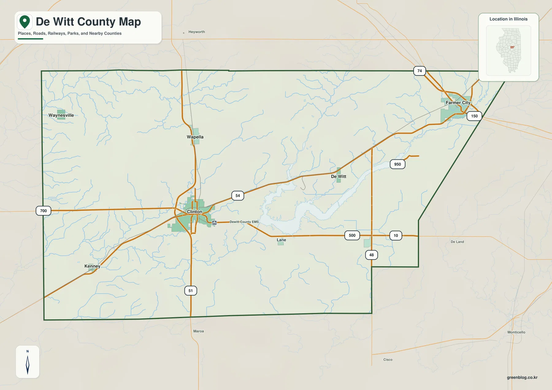
East of Clinton, the road pattern begins to interact with the long branches of Lake Clinton. The lake and its tributary valleys give the central-eastern county a more irregular form than the simpler road grid farther west. Farmer City and Weldon create northeastern and southeastern outer references, while Waynesville and Kenney help define the county’s western width.
Clinton has been the county seat since 1839
Illinois State Archives lists Clinton as the DeWitt County seat from 1839 to the present, with no earlier seat shown. The current courthouse remains on West Washington Street in Clinton. That continuity makes the city both the historical administrative center and the most practical starting point on the supplied road map.
Clinton and Farmer City anchor the city distribution
The simplified city graphic ranks Clinton first and Farmer City second. Wapella is third, Waynesville fourth, Weldon fifth, and Kenney sixth. The printed CITY INDEX lists 6,985 for Clinton, 1,885 for Farmer City, 480 for Wapella, 377 for Waynesville, 350 for Weldon, and 349 for Kenney.
No census year or statistical reference date appears beside those numbers, so this page does not present them as current population counts. They are treated only as values printed on the supplied map. The placement is more reliable as geographic information: Clinton occupies the central-western position, Farmer City is far northeast, Wapella and Waynesville spread across the north, and Weldon and Kenney fill different parts of the southern half.
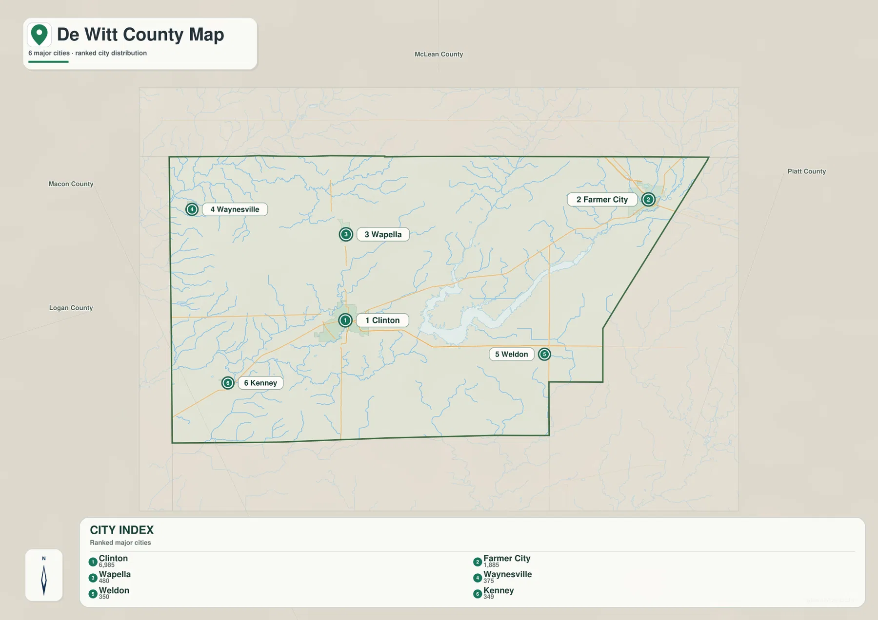
The stripped-down layout makes the county’s directions easier to remember. Clinton and Farmer City sit well apart, while Wapella and Waynesville define the northern side. Weldon is southeast of Clinton and Kenney southwest. Once those six locations are familiar, the detailed road and water maps become easier to use without losing orientation.
The CITY INDEX is not a current population table
For present-day population figures, use a Census release or another source that states its reference year. Because the De Witt County city graphic gives no date for its index, this article limits those numbers to describing the map’s ranking and marker sizes.
Lake Clinton and Salt Creek shape the central drainage
Lake Clinton is the strongest visual feature on the terrain-and-water sheet. Its long branches spread across the central-eastern county and connect with several low tributary corridors. Salt Creek approaches from the west through a broad valley, while Coon Creek and Tenmile Creek occupy neighboring drainage lines on the Clinton-to-lake side.
Kickapoo Creek and Buck Creek are labeled in the northwest, with Long Point Creek farther east. Deer Creek appears on the west-central side. North Fork Salt Creek descends through the northeastern half, and Trenkle Slough is marked near the eastern edge. South of the lake, Lake Fork Creek, Friends Creek, and Friends Creek Ditch form additional low channels.
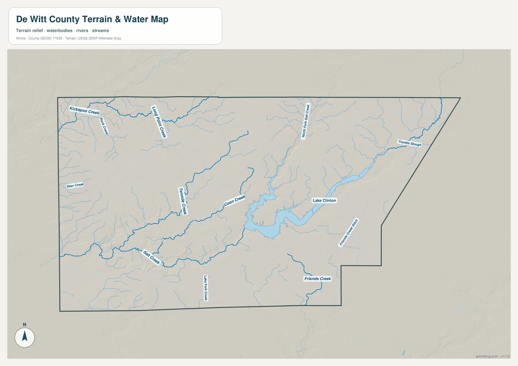
Illinois DNR describes Clinton Lake State Recreation Area around a roughly 4,900-acre lake whose construction began in the 1970s. The agency notes that the area had included upland prairie and bottomland deciduous forest before much of the land was later used for pasture and cropland. That local background fits the supplied terrain map, where the reservoir occupies a long branching lowland surrounded by rolling higher ground.
The water map does not show current lake or flood conditions
The terrain sheet locates the lake, creeks, slough, and surrounding relief at county scale. It does not report current Clinton Lake level, boating rules, flood-hazard boundaries, water depth, or access conditions. Current Illinois DNR, USGS, and other responsible-agency information should be used when the question depends on present conditions or safety.
North-central uplands stand above the Salt Creek lowlands
The elevation image gives De Witt County a strong contrast between broad high ground and deeply cut creek valleys. The largest brown upland occupies the north-central county, and another isolated high area appears farther west. In contrast, the southwest drops into a broad green Salt Creek lowland. Lake Clinton and its tributaries also occupy a long connected band of lower terrain through the center and east.
The map prints an actual countywide elevation range of about 185 to 250 meters and a mean near 220 meters. Its legend uses narrower color bands from roughly 191 to 241 meters, while the separate “Actual” line records the full minimum and maximum of the underlying dataset. Those endpoints describe De Witt County as a whole and should not be assigned directly to Clinton, Kenney, Farmer City, or any individual property.
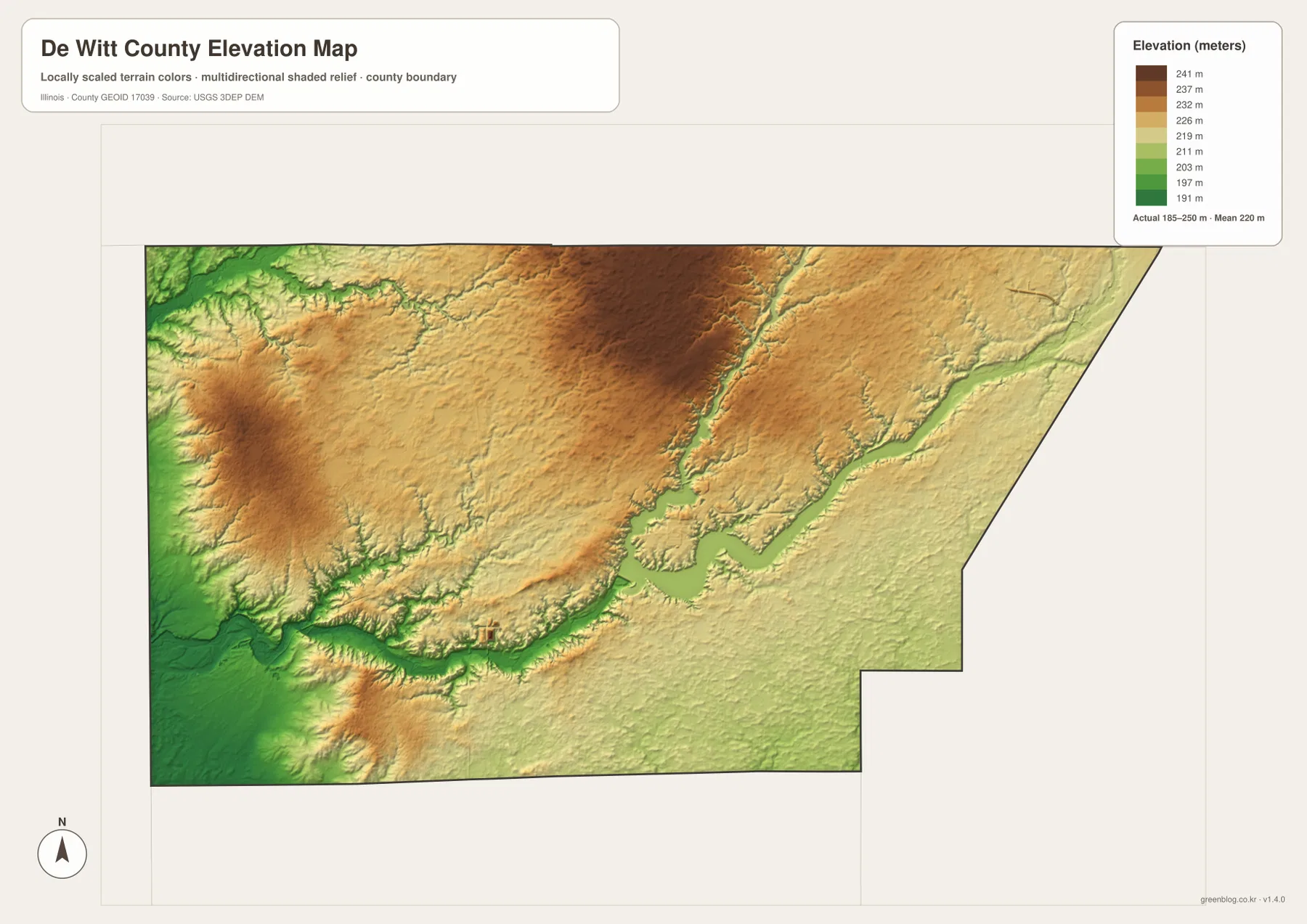
Comparing the water and elevation maps makes the green corridors easier to match. Salt Creek, Coon Creek, and the Lake Clinton branches occupy lower ground than the surrounding uplands. Small tributaries cut into the western and northern high areas, creating a more dissected surface than the road map suggests. The reservoir corridor is especially easy to follow because the water and low elevation band overlap over a long distance.
185 to 250 meters is a countywide range
A building site, road grade, drainage plan, or parcel needs point-specific elevation data or a professional survey. The 185–250 meter range is most useful for comparing De Witt County’s broad uplands with the Salt Creek and Lake Clinton lowlands, not for assigning an exact elevation to a town or address.
Keep Clinton fixed while switching between roads, water, and relief
A practical way to use the files is to keep Clinton as the fixed center. On the overview, follow Route 54 toward Farmer City and Route 51 north and south, then add Waynesville, Wapella, Kenney, and Weldon as outer references. The city graphic simplifies those same directions without the smaller roads and drainage lines.
Next, locate Lake Clinton and Salt Creek on the terrain sheet, then compare the same positions with the elevation colors. The lake and major creek corridors sit in lower green terrain, while the north-central and western uplands rise above them. Using the same landmarks across all files keeps settlement, drainage, and relief connected rather than turning each map into a separate exercise.
Use current transportation sources for driving conditions, dated Census data for population, current Illinois DNR or hydrologic sources for lake and flood questions, and point-level elevation or survey data for site work. Within those limits, the De Witt County maps are useful for printed references, lessons, presentations, and advance geographic orientation.
Frequently Asked Questions
What is the county seat of De Witt County, Illinois?
Clinton is the county seat. Illinois State Archives records Clinton in that role from the county’s establishment in 1839 to the present, and the current DeWitt County Courthouse is also located in Clinton.
Is Clinton Lake a natural lake?
Illinois DNR describes Clinton Lake as an approximately 4,900-acre reservoir whose construction began in the 1970s. The supplied terrain map also shows the long branching shape typical of a reservoir occupying several connected creek valleys.
Does 185 to 250 meters give Clinton’s elevation?
No. The elevation image identifies 185–250 m as the actual range across the De Witt County dataset and gives a mean of about 220 m. Exact elevation for Clinton or any specific road, building, or property requires point-specific elevation or survey data.
Sources and Reference Material
The article uses the supplied De Witt County maps together with the official references below. For current road conditions, Clinton Lake rules and water levels, legal boundaries, or exact point elevations, consult the responsible agency’s latest material rather than relying on a static county reference map.
- Illinois State Archives – DeWitt County – county establishment, name origin, and Clinton county-seat history
- Illinois DNR – Clinton Lake State Recreation Area – lake size, construction period, and local natural-history context
- Illinois Courts – DeWitt County Courthouse – current courthouse location in Clinton
- USGS National Hydrography – river, stream, and lake reference data
- USGS 3D Elevation Program – elevation and terrain data
Map File Information
The ZIP file contains the high-resolution JPG originals for the De Witt County overview, city map, terrain-and-water map, and elevation map. Each landscape JPG is 3,638 × 2,572 pixels, which keeps De Witt County town names, Route 54 and 51 labels, tributary names, and the relief shading legible at larger viewing or print sizes.
- Included Files: 4 high-resolution JPG maps
- Printable Size: 3,638 × 2,572 pixels each
Related Maps
Green Map creates custom-edited map images using open geographic data sources such as geoBoundaries, Natural Earth, OpenStreetMap, and government open data.
These maps are edited visual materials, not raw data files, and are provided for education, documents, presentations, and graphic reference.