Power County occupies a varied part of southeastern Idaho where the broad water and open ground around American Falls Reservoir give way to long valleys, creek-cut ridges, and much higher country toward the south and east. This Power County Map page brings together American Falls, Rockland, Arbon Valley, the main road corridors, the Snake River and reservoir, smaller streams, and the county-wide elevation pattern. High-resolution A3 JPG versions of the same maps are available in one ZIP from the download box below.
The most useful way to understand the county is to notice how quickly its character changes away from American Falls. The county seat sits near the reservoir and a cluster of major roads in the northwestern part of the county. Rockland lies well to the south in a narrower valley, while the eastern and southeastern sections contain far fewer city labels and much more visible relief. The four supplied maps are therefore most informative when used together rather than as four copies of the same view.
Table of Contents
American Falls at the meeting point of reservoir, roads, and county boundary
The general county map places American Falls beside the large reservoir at the northern end of the main settled corridor. I-86 and US 30 are labeled close to the city, while ID 39 approaches from the northwest. ID 37 runs south through Rockland and continues toward the county’s southern edge. These routes make American Falls the clearest road focal point on the map, but the county itself extends far beyond that urban cluster into broad western ground and deeply dissected southern terrain.
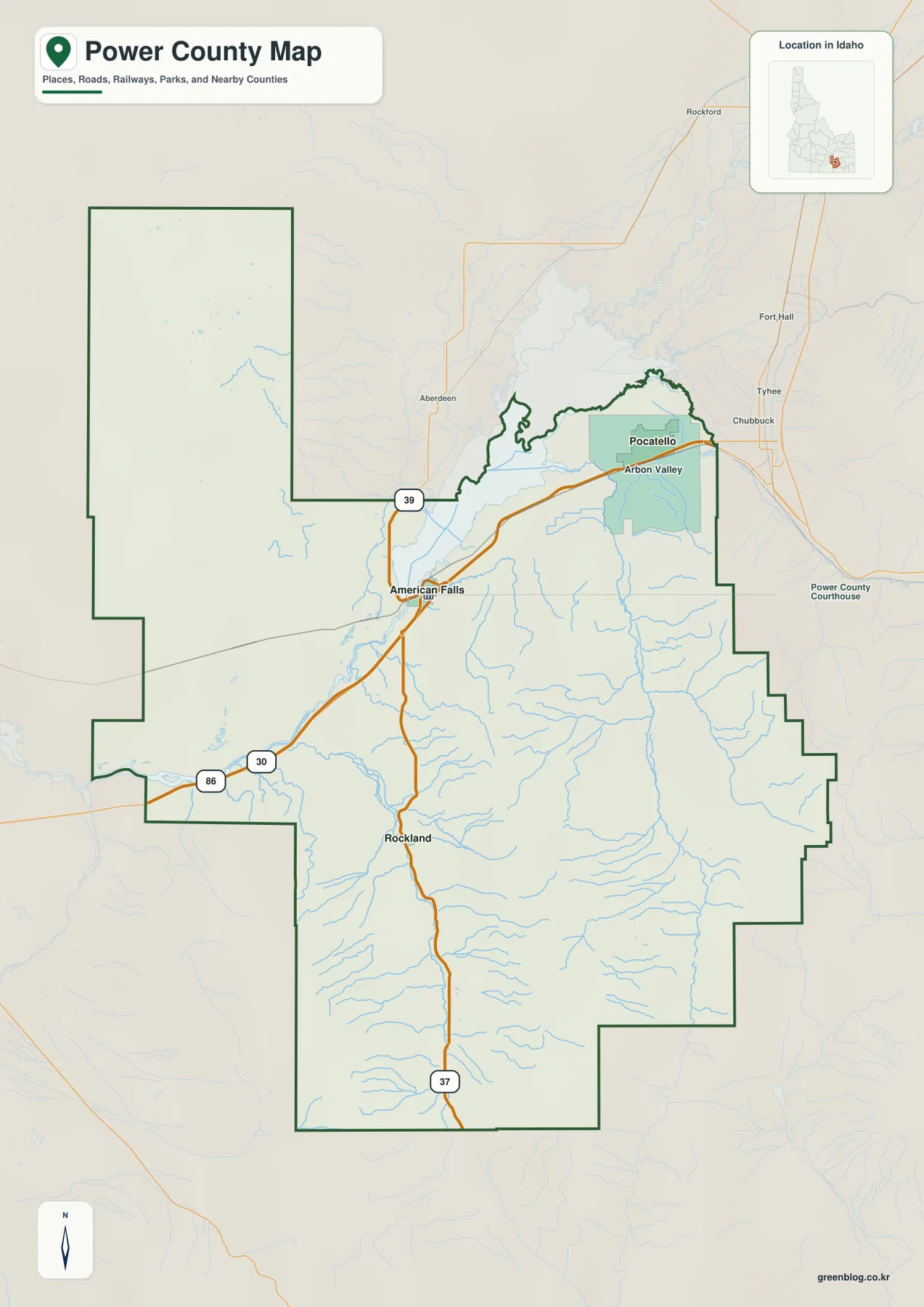
The county outline is unusually easy to recognize. A large western arm stretches northward, the eastern boundary steps in and out several times, and the southern half narrows around higher terrain. Pocatello is labeled near the northeastern edge of the map, with Fort Hall farther north, giving useful context for Power County’s position west and southwest of the Pocatello area. Arbon Valley is labeled east of American Falls, while Rockland anchors the central-southern road corridor.
Power County’s official history says the county was established in 1913 and identifies American Falls as the county seat. The same local history describes a landscape of plains and major valleys bounded by mountain ranges, which matches the strong contrast visible between the open northwestern portion and the more rugged south and east. The general map is designed for orientation and county-scale relationships; it should not be treated as a parcel, ownership, zoning, or legal survey map.
Two ranked cities and a large rural interior
The supplied city map is intentionally simple. It ranks American Falls first and Rockland second, with city-index values of 4,712 and 228 printed in the key. Those figures are values used by the map dataset and should not be assumed to be the latest official population estimates. For current population statistics, a current Census source is more appropriate. On this map, the more important point is geographic: the two principal incorporated places occupy only a small part of a county that spreads across a much larger rural landscape.
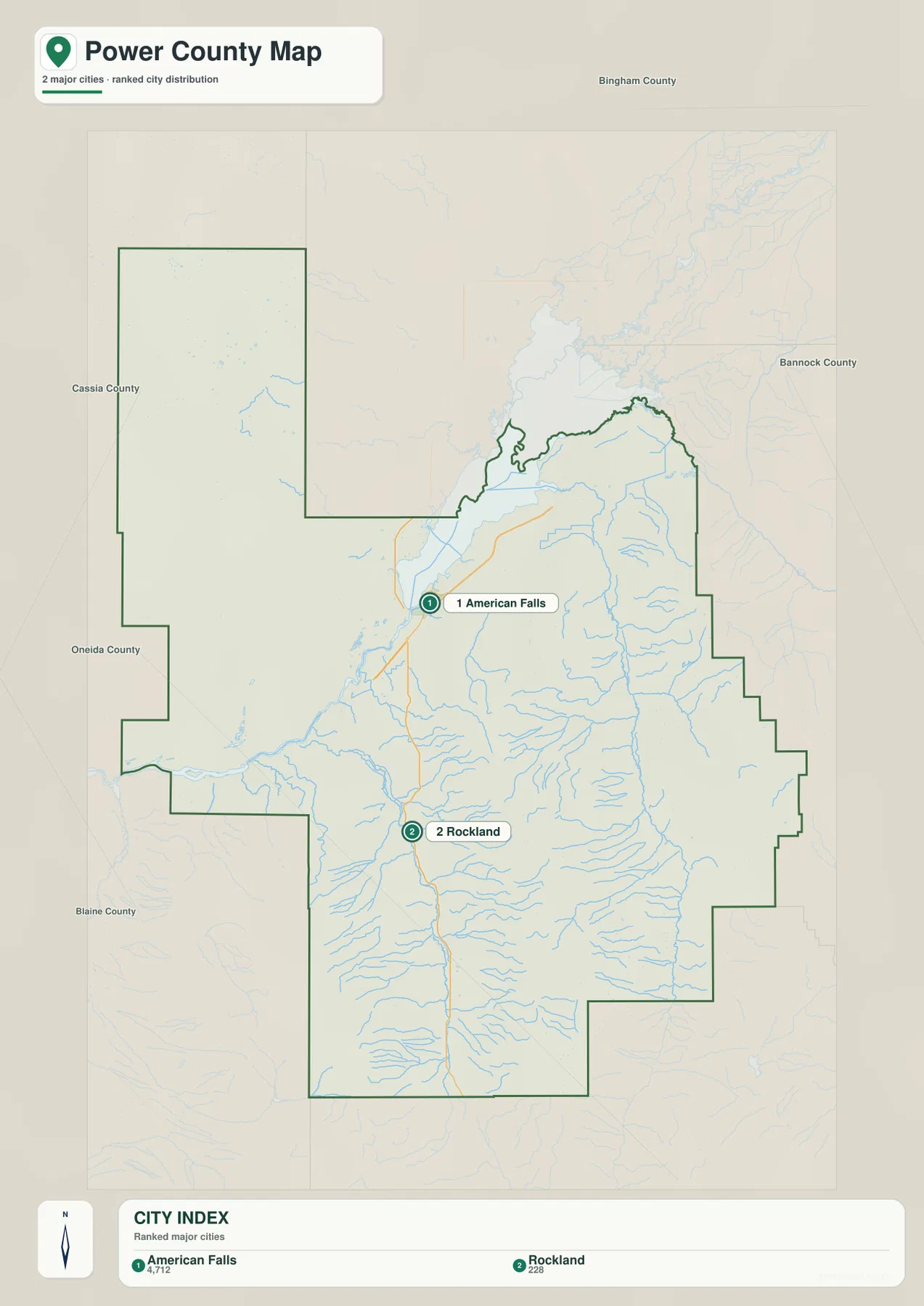
American Falls is positioned near the northern road-and-water hub, whereas Rockland is isolated farther south along the ID 37 corridor. Between and beyond them, the map shows extensive drainage lines but few major urban markers. That contrast is useful for readers who are trying to understand why the county can look open and sparsely settled even though American Falls has a clear town center and transportation connections.
The margins of the city map identify Bingham County to the north, Bannock County to the east, Oneida County to the southwest, and Cassia and Blaine counties along the western side. Power County’s own historical page lists the same neighboring counties. Seeing those names around the boundary helps explain the county’s long northwestern extension and the stepped eastern edge better than a city list alone. It also makes clear that American Falls lies toward one side of the county rather than in its geometric center.
Snake River, American Falls Reservoir, and creeks cutting the high country
The terrain-and-water map changes the emphasis completely. American Falls Reservoir dominates the north, and the Snake River enters from the west before continuing toward that broad water body. The Bureau of Reclamation confirms that American Falls Dam and Reservoir lie in Power, Bannock, and Bingham counties and form an important part of the Upper Snake reservoir system. The Portneuf River is also labeled near the northeastern side, approaching the reservoir from the Pocatello direction.
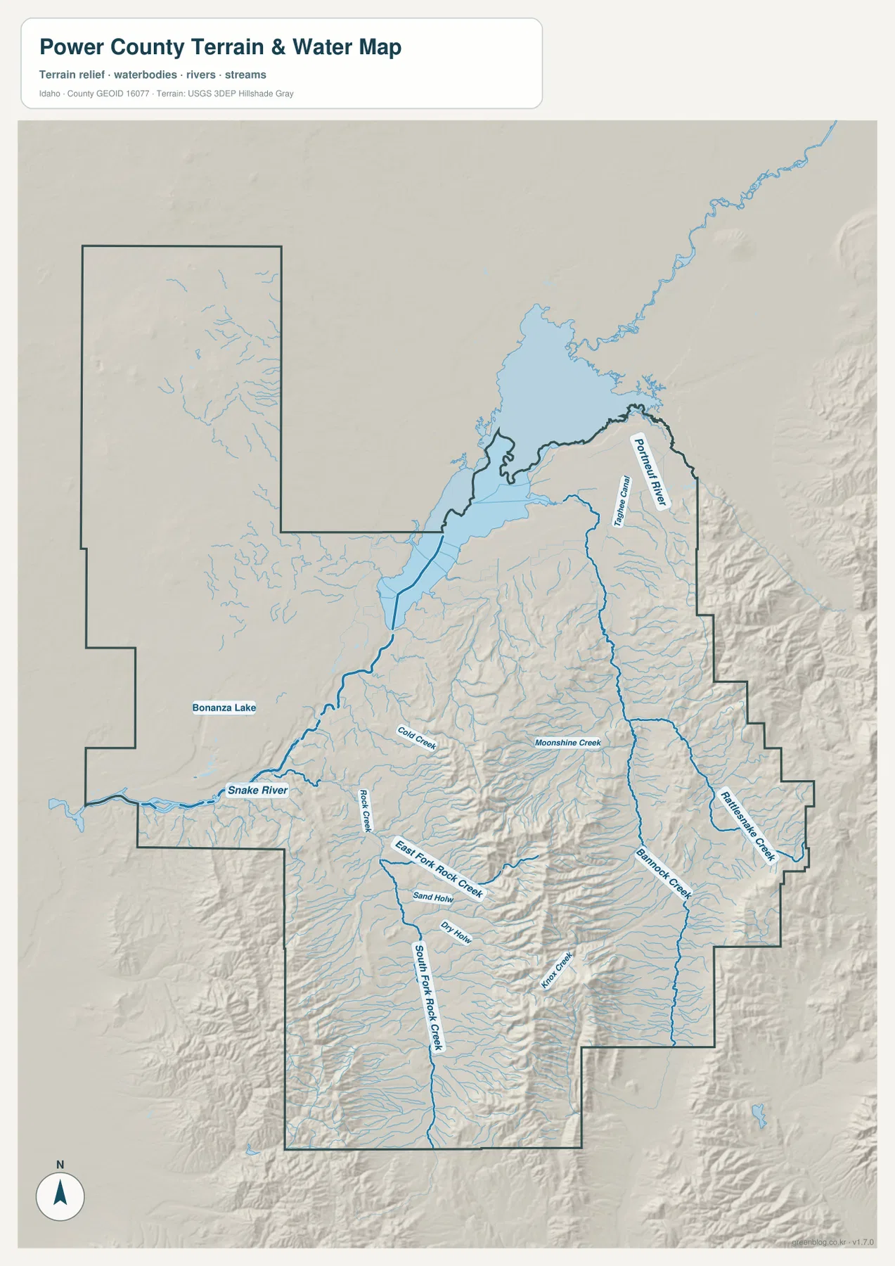
South of the reservoir, the water pattern becomes finer and more closely tied to mountain valleys. Bannock Creek runs through the eastern part of the county, while Rattlesnake Creek follows another long drainage near the eastern boundary. Around the Rockland area, Rock Creek and its East Fork and South Fork divide the southern landscape. Cold Creek, Moonshine Creek, Kinport Creek, Sand Hollow, and Dry Hollow are among the smaller named features that make the relief easier to interpret.
Bonanza Lake appears as a small water body in the western interior, creating a sharp size contrast with American Falls Reservoir. The shaded relief beneath the blue water lines is especially useful because it shows that many southern streams occupy narrow valleys between ridges rather than crossing a flat plain. This is a reference map for water-feature location and terrain context. It is not a flood-hazard map, depth chart, water-rights record, water-quality assessment, or navigation product.
From 1,279-meter lowlands to 2,654-meter ridges
The elevation map gives the clearest explanation for the visual difference between northwestern Power County and the southern interior. Its legend reports an actual county range of about 1,279 to 2,654 meters, with a mean of about 1,576 meters. Broad green areas dominate around the reservoir, American Falls, and much of the western side. Higher yellow and brown terrain becomes progressively more common across the central ridges, the southeastern side, and the mountains south of Rockland.
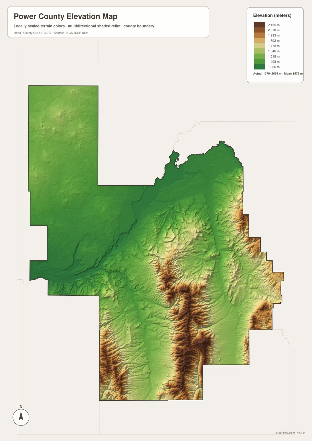
Comparing this surface with the water map explains several drainage directions. The South Fork Rock Creek system occupies valleys between the high southern ridges, while Bannock Creek and Rattlesnake Creek follow lower corridors in the eastern high country. American Falls, by contrast, sits close to a much broader low area beside the reservoir. Rockland lies at a transition where the road corridor continues south into increasingly rugged terrain.
The elevation colors are locally scaled for Power County. A green area here should not be assumed to represent the same absolute elevation as green on a different county map. The surface is useful for comparing broad landform and elevation differences, but it is not survey-grade measurement. A building site, road grade, or engineering project needs more precise elevation data and field-appropriate methods.
Choosing the best view for American Falls, Rockland, water, or relief
Readers looking for the county outline, named places, and highway relationships should begin with the general map. The city map is faster when the question is simply where American Falls and Rockland sit within the county. The terrain-and-water map is the better choice for the reservoir, Snake River, Portneuf River, Bannock Creek, Rattlesnake Creek, and the Rock Creek branches. The elevation map is most useful when the goal is to compare the low reservoir country with the mountain ridges farther south and east.
- Road and boundary orientation: use the general map for American Falls, Rockland, Arbon Valley, I-86, US 30, ID 37, and ID 39.
- Settlement pattern: use the ranked city map to see how American Falls and Rockland occupy very different parts of the county.
- Rivers and creeks: use the terrain-and-water map for American Falls Reservoir, the Snake River, and the dense southern drainage network.
- Elevation contrast: use the elevation map to compare terrain from roughly 1,279 meters to 2,654 meters.
Power County is a good example of why a single road map can miss much of a place’s character. The northwestern part is defined by American Falls, the reservoir, and broad low ground, while the county’s southern half is shaped by long creeks, narrow valleys, and steeply rising ridges. Using the maps side by side lets a reader connect transportation, settlement, water, and relief without assuming that one view answers every geographic question.
The WebP images on this page are optimized for convenient on-screen viewing. For printing, offline use, classroom material, or closer inspection, the download package contains the original high-resolution A3 JPG versions of the county, city, water, and elevation maps.
Frequently Asked Questions
Where is American Falls Reservoir in relation to the rest of Power County?
The reservoir occupies the northern and northwestern part of the mapped county, with American Falls immediately to its south. The Snake River approaches from the west, and the Portneuf River is labeled on the northeastern side. The general map is best for relating the reservoir to roads and towns, while the water map shows the river and creek network in more detail.
How different is the terrain south of Rockland from the American Falls area?
The elevation contrast is substantial. Broad low terrain surrounds American Falls and the reservoir, whereas the country south and east of Rockland contains repeated ridges and valleys that rise into the highest color classes on the map. The mapped county range is about 1,279 to 2,654 meters, so the southern high country stands well above the reservoir-side lowlands.
Are the 4,712 and 228 values on the city map current official populations?
They should be treated as values from the city dataset used to create the supplied map, not as a guarantee of the latest official population estimate. The city map is most useful for showing that American Falls is the larger ranked place and that Rockland is a much smaller settlement farther south. Use a current Census source when exact up-to-date population figures are required.
Map File Information
The ZIP contains four high-resolution A3 JPG maps of Power County, matching the map types shown on this page.
- Included Files: county map, city map, terrain and water map, elevation map
Related Maps
Sources and references
- Power County General History – official county background, American Falls, and regional landscape information
- Bureau of Reclamation – American Falls Resource Management Plan – official information about American Falls Dam and Reservoir
- U.S. Census Bureau TIGER/Line Shapefiles – county boundary and geographic reference data
- USGS National Hydrography – official river, creek, and water-feature reference data
- USGS 3D Elevation Program – official elevation and terrain data
Green Map creates custom-edited map images using open geographic data sources such as geoBoundaries, Natural Earth, OpenStreetMap, and government open data.
These maps are edited visual materials, not raw data files, and are provided for education, documents, presentations, and graphic reference.