Nez Perce County has a striking contrast between the low river country around Lewiston and the much higher terrain that extends south through the county. This Nez Perce County Map page brings together the county boundary, major places and roads, the Clearwater and Snake rivers, smaller streams and lakes, and a countywide elevation view. The download box near the end of the article provides the same map set as high-resolution JPG files in a ZIP archive.
The four supplied maps answer different practical questions without requiring the reader to sort through a dense GIS interface. The general county map is useful for orientation and road context, while the city map makes the relationship between Lewiston, Lapwai, Culdesac, and Peck easier to compare. The terrain-and-water map emphasizes the river valleys and tributaries, and the elevation map shows just how sharply the land rises from the western lowlands into the southern high country.
Table of Contents
A county shaped around Lewiston, eastern road corridors, and a long southern extension
The county outline immediately explains why a single map view is helpful here. Lewiston sits near the broad western edge, while the county reaches east through a narrower arm and then extends far south in a long, irregular section. Lapwai lies east of Lewiston near the main north-south road corridor, Culdesac is farther southeast, and Peck occupies the eastern side near the narrow projection of the county boundary.
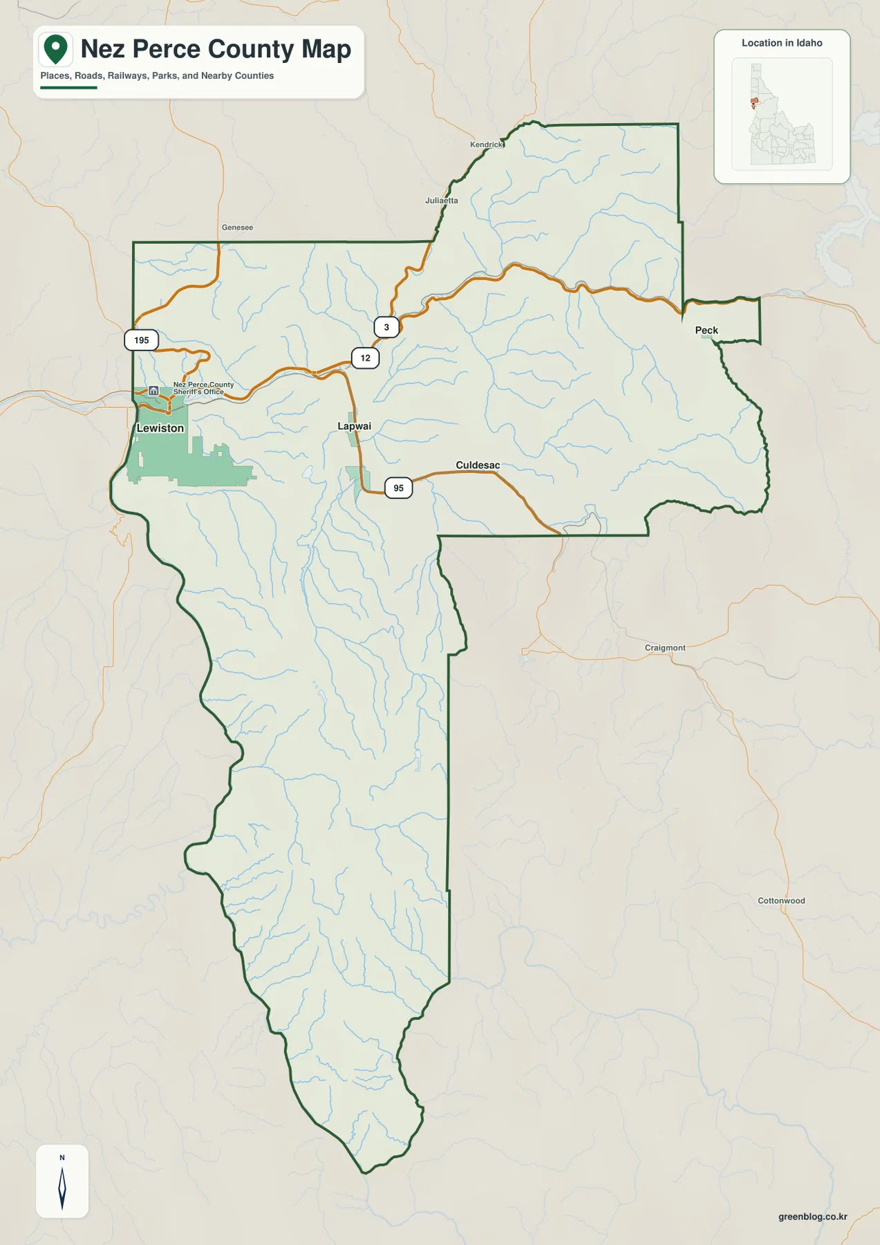
US 12 runs east from the Lewiston area across the northern part of the county, while US 95 connects the Lewiston-Lapwai area with the country to the south. ID 3 appears through the central-northern corridor. Roads are more concentrated around the western and north-central settlements, whereas the long southern section shows fewer major road symbols and many more small drainage lines. That contrast makes the overall settlement pattern visible even before moving to the dedicated city map.
Nearby labels such as Genesee, Kendrick, Juliaetta, Craigmont, and Cottonwood provide useful context outside or along the county edge. They help place Nez Perce County within the surrounding part of Idaho without turning the map into a parcel or legal-boundary product. For precise survey lines, ownership, zoning, or parcel questions, readers should use the county’s official mapping tools or authoritative boundary data rather than this general reference map.
Lewiston as the hub for Lapwai, Culdesac, and Peck
The city-connections map identifies Lewiston as the hub and then marks Lapwai, Culdesac, and Peck farther east. The four places are not distributed evenly across the county. Lewiston anchors the western lowlands, Lapwai is the closest of the three connected places, Culdesac lies farther southeast, and Peck is separated from Lewiston by the broad eastern portion of the county. No indexed major city is shown in the long southern extension, which makes the northern concentration of settlements easy to see.
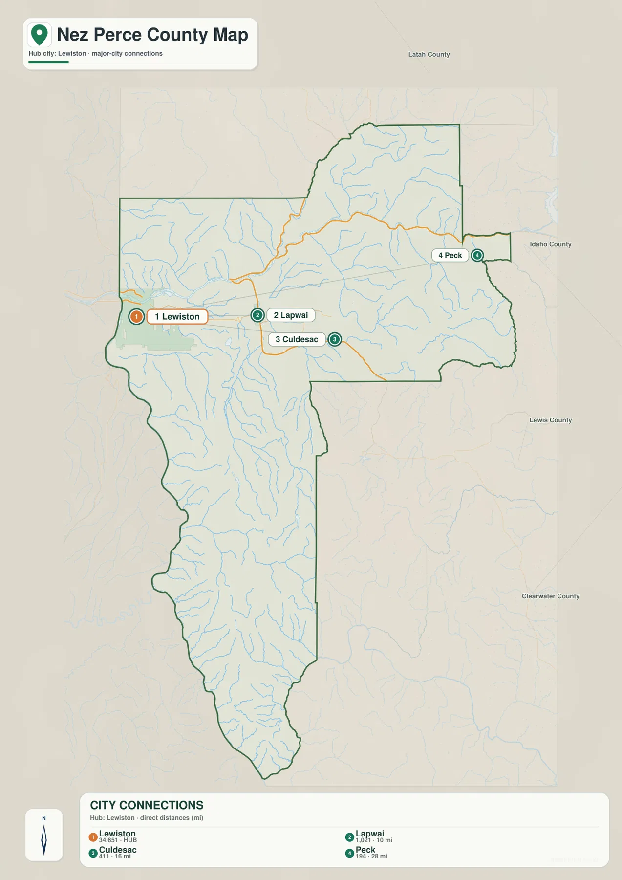
The map lists Lapwai at about 10 miles from Lewiston, Culdesac at about 16 miles, and Peck at about 28 miles. These are straight-line distances calculated between mapped city locations, not driving distances. Road travel can be longer because routes follow river valleys, grades, and the available highway network, so the distance labels are best used for comparing relative spacing rather than planning a trip.
Putting the city symbols beside the road network adds another layer of context. Lewiston and Lapwai sit close to the principal corridors, Culdesac follows the US 95 direction to the southeast, and Peck lies near the far eastern side. For a reader trying to understand where the county’s main named communities sit in relation to one another, this map is more useful than a simple alphabetical city list.
Clearwater and Snake rivers define the low country, while tributaries reach into the uplands
The terrain-and-water map is dominated by two large rivers in the western and northern part of the county. The Clearwater River crosses the north-central area toward Lewiston, where it joins the Snake River along the western edge. Farther north, the Potlatch River feeds toward the Clearwater system. Cottonwood Creek and Lapwai Creek are prominent named tributaries in the central portion of the county, and the shaded relief makes their valleys stand out from the surrounding slopes.
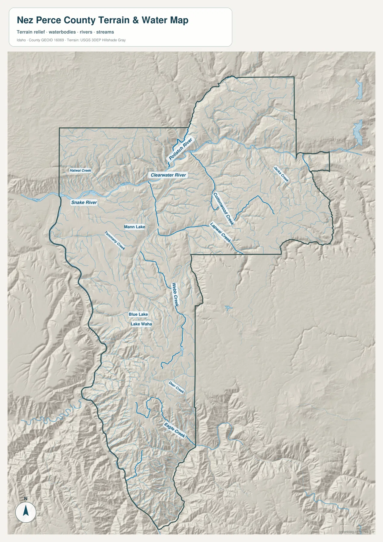
South of the main river corridor, the drainage network becomes more fragmented and follows narrower valleys through higher terrain. Webb Creek runs through a long central-southern section, with Deer Creek and Eagle Creek among the named streams farther south. Lake Waha and Blue Lake appear in the south-central uplands, while Mann Lake is marked closer to the western side. These features give the reader several fixed landmarks for comparing the water map with the elevation map.
Smaller names such as Hatwai Creek, Tammany Creek, and Jacques Creek show that the map includes more than the two large rivers. Their locations are useful for orientation, but the blue lines should not be interpreted as flood zones, water-right boundaries, navigation channels, or statements about current water quality. The map is designed to show where mapped water features sit within the county’s terrain.
From 219-meter river valleys to terrain above 1,600 meters
The elevation map gives Nez Perce County a very different visual character. Its stated actual elevation range is approximately 219 to 1,630 meters, with a mean of about 785 meters. The Lewiston area and the major river valleys appear in the darkest greens, identifying the lowest parts of the county. Low corridors also extend east along the Clearwater system before the surrounding ground rises into ridges and uplands.
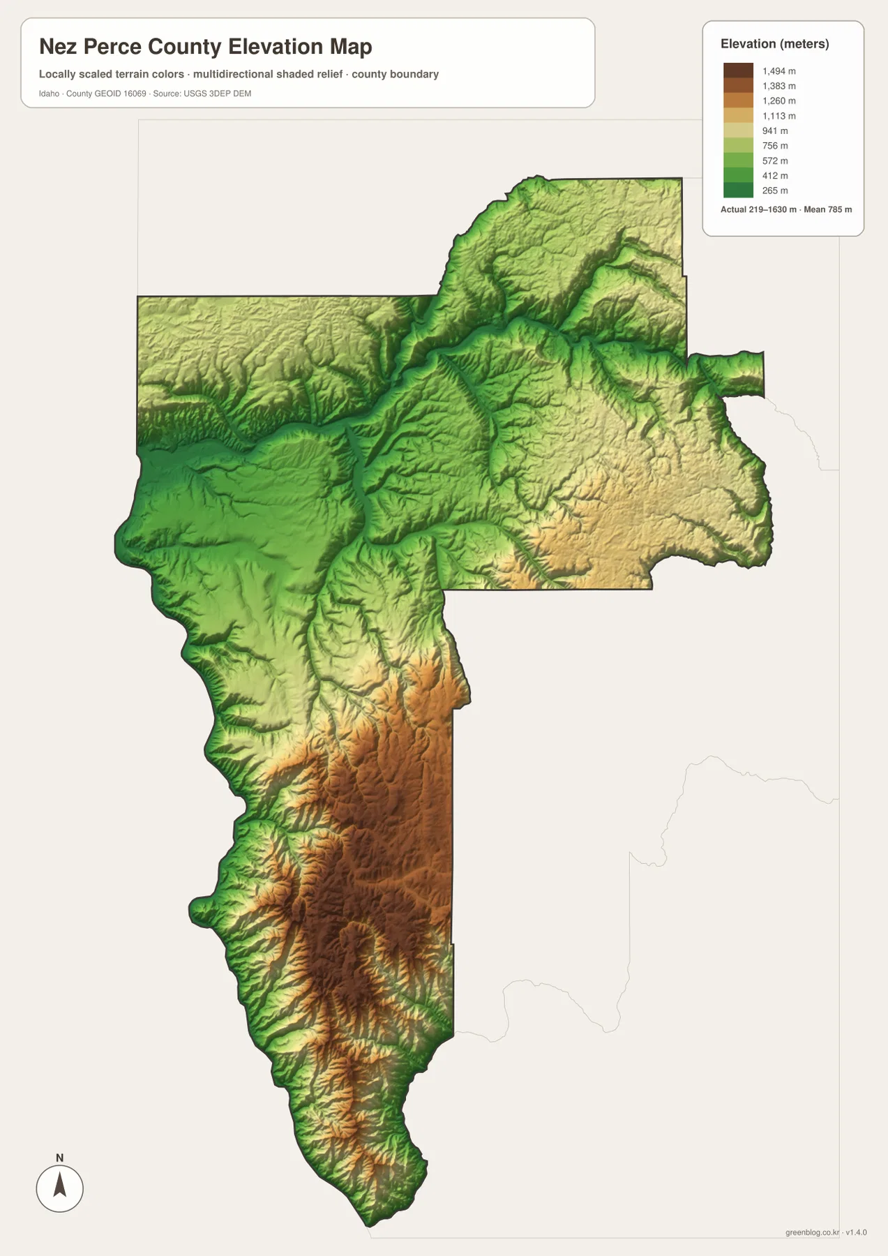
Higher colors become more common toward the central-east and especially through the long southern section. There, ridges and narrow valleys create a much rougher surface than the broad lowlands around Lewiston. The contrast between these areas is large enough that the elevation map helps explain several patterns seen on the other maps: large rivers occupy the lower corridors, major settlements are concentrated toward the northwest, and the far south contains fewer indexed cities and more broken terrain.
This elevation surface is generalized for countywide viewing. It is suitable for comparing broad differences in height, but it should not be used as a survey, engineering grade, road design measurement, or site-specific elevation certificate. Detailed work should rely on the original USGS elevation data or a qualified local source.
Choosing the right map for a boundary, city, water, or terrain question
The general county map is the best starting point when the goal is to see the full outline, major roads, and named communities together. The city map is better for comparing where Lewiston, Lapwai, Culdesac, and Peck sit relative to one another. Water features are much clearer on the terrain-and-water map, while the elevation map is the quickest way to compare the low western river country with the high southern terrain.
- Boundary and road context: use the county map to compare the county outline with Lewiston, Lapwai, Culdesac, Peck, US 12, US 95, and ID 3.
- City spacing: use the connections map to compare directions and straight-line distances from Lewiston to Lapwai, Culdesac, and Peck.
- Rivers and tributaries: use the water map for the Snake and Clearwater rivers, Potlatch River, Lapwai Creek, Lake Waha, and other labeled water features.
- Elevation contrast: use the elevation map to compare terrain from about 219 meters in the low valleys to roughly 1,630 meters in the highest mapped areas.
The WebP images on the page are convenient for quick viewing, while the downloadable archive is better suited to printing, classroom use, local presentations, and offline reference. Each JPG keeps the same map theme at the original high resolution supplied with the county map package, so readers can use one file by itself or compare all four.
Frequently Asked Questions
Are the city distances on the map driving distances?
No. The labels show straight-line distances from Lewiston to the other indexed city locations: about 10 miles to Lapwai, 16 miles to Culdesac, and 28 miles to Peck. Driving distances can be longer because roads follow the available highway network, grades, and river valleys. Use a current routing service when planning an actual trip.
Where do the Clearwater and Snake rivers meet on these maps?
The water map shows the Clearwater River crossing the northern part of the county toward Lewiston and joining the Snake River near the western edge. The same area appears among the lowest elevations on the elevation map, making it easy to compare the river junction with the surrounding low valley terrain.
What is the main elevation difference across Nez Perce County?
The strongest contrast is between the low western river valleys and the much higher terrain in the long southern part of the county. The map states an actual range of about 219 to 1,630 meters and a mean near 785 meters. Those colors are intended for broad countywide comparison, not parcel-level surveying.
Map File Information
The download contains high-resolution JPG versions of the Nez Perce County general map, city-connections map, terrain-and-water map, and elevation map.
- Included Files: Use only the versions confirmed in the article and supplied images
- File Type: Use the confirmed download contents
- Intended Use: Printing, education, presentations, and map-based projects
Related Maps
Sources and references
- Nez Perce County official website – county government and local information
- Nez Perce County Comprehensive Plan – county background and planning material
- U.S. Census Bureau TIGER/Line Shapefiles – county boundaries and geographic reference data
- USGS National Hydrography – rivers, streams, and mapped water features
- USGS 3D Elevation Program – elevation and terrain data
Green Map creates custom-edited map images using open geographic data sources such as geoBoundaries, Natural Earth, OpenStreetMap, and government open data.
These maps are edited visual materials, not raw data files, and are provided for education, documents, presentations, and graphic reference.