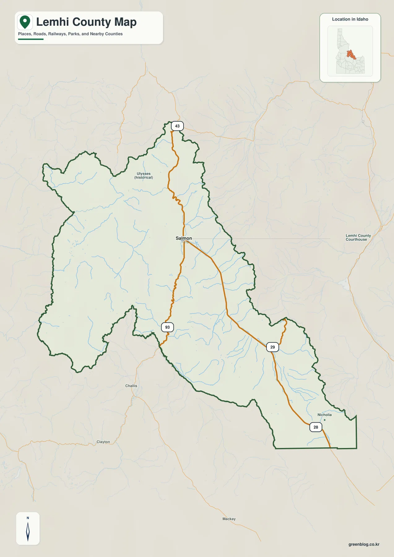
Lemhi County stretches across a broad mountain landscape in east-central Idaho, with Salmon near the north-central part of the county and Leadore far down the long southeastern valley. The map makes the county’s basic geography easy to recognize: US 93 passes through Salmon, Route 28 continues through the Lemhi Valley toward Leadore, and large mountain blocks occupy much of the west and the eastern margins. The Salmon River and Lemhi River provide two of the clearest geographic guides through this rugged area. This page explains those visible relationships and provides downloadable high-resolution JPG versions of the same maps for closer viewing or printing.
The settlement pattern is sparse compared with counties built around several closely spaced towns. Lemhi County’s official About page names communities including Salmon, Leadore, North Fork, Gibbonsville, Shoup, and Lemhi, while the supplied ranked-city map highlights only Salmon and Leadore as its two major cities. That distinction matters: the city map is useful for showing the relative position of the two ranked places, but it should not be treated as a complete inventory of every community in the county.
The WebP images in the article are lighter previews for the web. The download archive contains four 2572×3638-pixel JPG files covering the county map, ranked cities, terrain and water, and elevation. These maps are intended for regional orientation, study, printing, and general reference. They are not parcel surveys, real-time road products, flood-hazard maps, navigation charts, or engineering-grade elevation plans.
Table of Contents
Salmon anchors the road network across a long mountain county
The general county map is easiest to read from Salmon outward. US 93 runs through Salmon and continues north and southwest, making it the clearest long-distance road reference on the page. From Salmon, the transportation pattern opens toward the southeast, where the route toward Leadore follows the long Lemhi Valley. Route numbers 28, 29, and 43 also appear on the map, helping separate the southeastern corridor from the northern and eastern branches around Salmon.
The shape of the county is just as important as the road labels. The western half spreads into a broad mountainous block, while the southeastern portion narrows into a long valley corridor. Ulysses appears as a historical place label in the northwest, and Nicholia is marked near the southeastern part of the county. Those smaller names help show how little of the county is occupied by large settlements. Outside the Salmon area, mountain relief and drainage features dominate much of the map.
Use this map when you need roads, place names, and the county outline on one page. It is especially useful for understanding how Salmon sits between the western mountains and the Lemhi Valley leading southeast. It should not be used to decide legal parcel boundaries, road ownership, or current road conditions. Those questions require current county, state, or federal records.
Two ranked cities reveal how widely settlements are spaced
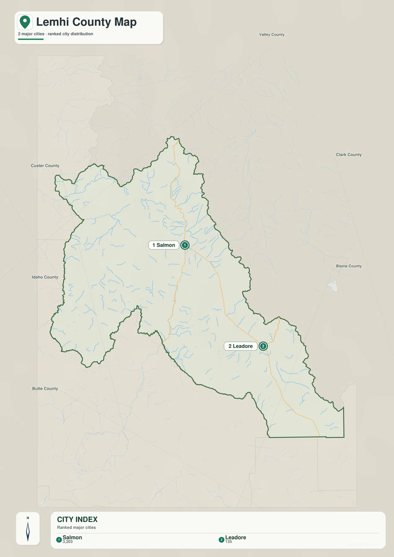
The city map ranks only two places: Salmon and Leadore. Its index shows Salmon at 3,203 and Leadore at 135. Those numbers should be understood as the values used to build this particular map rather than as a substitute for the latest Census estimate. For map reading, the more useful point is the contrast in location: Salmon sits near the county’s central northern corridor, while Leadore is far to the southeast in the long Lemhi Valley.
The large gap between the two labeled cities is a defining feature of this county map. There is no dense chain of major towns filling the space between them. Instead, the map is mostly occupied by river valleys, mountain slopes, and smaller roads. Lemhi County’s official website lists several additional communities that do not appear as ranked cities here, so the two-city display should be read as a simplified hierarchy rather than a complete settlement map.
No straight-line connector or distance label is drawn between Salmon and Leadore on this version of the city map. As a result, it is best for relative position rather than trip planning. Pairing it with the general map shows the context more clearly: Salmon is tied to US 93 and several branching routes, while Leadore lies along the southeastern road and river corridor.
The Salmon and Lemhi rivers organize the county’s major valleys
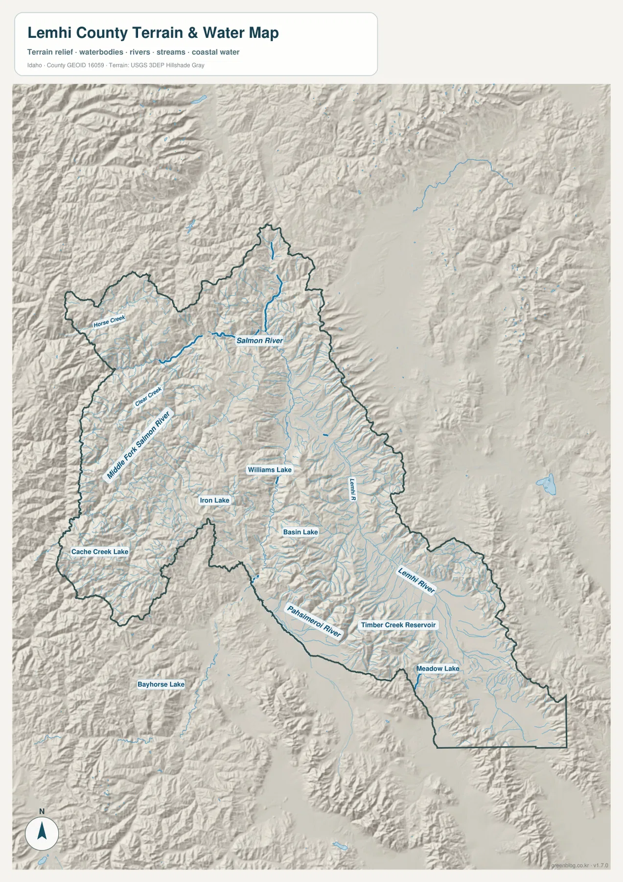
The terrain-and-water map is built around two major river corridors. The Salmon River passes through the northern and north-central part of the county before bending west into the mountain interior. The Lemhi River follows the long southeastern valley toward Salmon. Seeing both rivers together explains why the county does not read as one broad basin: separate mountain ranges divide the drainage into long, narrow valleys with very different orientations.
The western mountains contain additional drainage labels, including the Middle Fork Salmon River, Horse Creek, and Clear Creek. Farther south and east, the map marks lakes and reservoirs such as Williams Lake, Iron Lake, Basin Lake, Timber Creek Reservoir, and Meadow Lake. These smaller water features are useful landmarks because many parts of Lemhi County have few large place labels. They also make it easier to match water corridors with the surrounding ridges shown by the shaded terrain.
The blue lines and named water bodies are reference features only. This is not a flood map, depth chart, water-rights map, navigation product, or real-time streamflow display. If a trip, fishing plan, rafting route, or water-management decision depends on current conditions, check the relevant land-management agency or USGS source. On this page, the water map is most useful for understanding where the major rivers, tributaries, lakes, and valleys sit in relation to one another.
Elevation rises from an 885-meter valley floor to 3,486-meter ridges
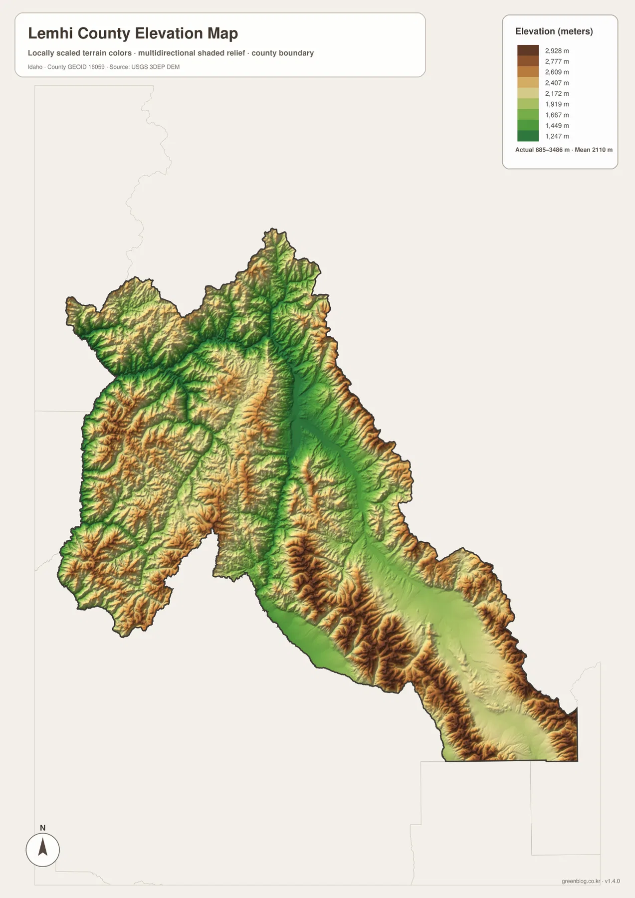
The elevation map reports an actual county range of about 885 to 3,486 meters, with a mean elevation of 2,110 meters. Green marks the lower valley terrain, while yellows and browns identify progressively higher slopes and ridges. The broadest low corridor runs from the Salmon area southeast through the Lemhi Valley. In contrast, the western mountain block and the ridges along the eastern side of the county rise sharply above the valley floor.
This relief pattern helps explain both the roads and the rivers. The lower Lemhi Valley provides a long corridor where the river, road, and settlements can follow the same general direction. In the west, deep tributary valleys cut through much higher terrain, producing the dense ridges and branching drainage seen on the water map. The contrast is substantial: the difference between the map’s reported minimum and maximum is more than 2,600 meters.
The elevation surface is meant for county-scale comparison rather than site measurement. Do not use the color of a single location as a survey-grade elevation for a building, road, parcel, or engineering project. The map is best for recognizing the low Salmon and Lemhi river corridors and the much higher mountain terrain around them. Precise work should rely on original elevation data such as the USGS 3D Elevation Program and, when necessary, professional field surveying.
Reading roads, rivers, and relief together
A useful way to study Lemhi County is to move from the simplest map to the most physical one. Start with the general map and locate Salmon, US 93, the southeastern route toward Leadore, and the broad western mountain area. Next, use the city map to strip away extra labels and compare the positions of Salmon and Leadore. The water map then shows which valleys are occupied by the Salmon River, Lemhi River, and smaller tributaries.
The elevation map completes the picture. It shows why the southeastern road and river follow such a persistent corridor and why the western half of the county contains fewer major road labels. The Lemhi Valley stands out as lower ground bordered by high ranges, while western tributaries cut into rugged terrain before reaching larger river systems. Switching between the four files therefore gives a clearer result than forcing roads, city ranking, water labels, and elevation into one crowded image.
For general orientation or a printed reference sheet, the county map is the best first choice. Use the city map when the goal is simply to compare the two ranked places. Choose the water map for named rivers, tributaries, lakes, and reservoirs, and the elevation map when the main question is where the county is low or high. The download archive keeps all four topics in separate JPG files so the reader can enlarge or print only the map needed for a particular task.
Frequently Asked Questions
Which map is best for locating Salmon and Leadore together?
Start with the general county map. It places Salmon together with US 93 and the southeastern road corridor, so Leadore can be understood within the same road-and-boundary context. The ranked-city map is cleaner for comparing only the two cities, but it removes much of the road and place detail that explains how they fit into the county.
How do the Salmon River and Lemhi River differ on the map?
The Salmon River crosses the northern part of the county near Salmon and then bends west through rugged mountain country. The Lemhi River follows the long southeastern valley toward Salmon. On the terrain-and-water map, those two corridors are visually distinct, and the smaller creeks, lakes, and reservoirs help show how the surrounding mountain drainage feeds into them.
Can the 885–3,486 meter elevation range be used for engineering work?
No. Those values summarize county-scale relief and are useful for comparing valleys with high ridges, but they do not provide survey-grade elevation for a specific site. Engineering, construction, drainage, or property work should use original elevation datasets and professional surveying where required.
Map File Information
Download the high-resolution JPG versions of the Lemhi County maps in one ZIP file for printing, closer viewing, or offline reference.
- Included Files: county map, ranked city map, terrain and water map, elevation map
- Printable Size: 2572×3638 pixels for each JPG
- File Type: ZIP containing 4 JPG files
Related Maps
Sources and references
County background and community information are available from the official Lemhi County About page. For local historical context in Salmon, see the National Park Service page for the Lemhi County Historical Society & Museum.
For geographic reference data, see the U.S. Census Bureau TIGER/Line Shapefiles for boundaries, USGS National Hydrography for rivers and streams, and the USGS 3D Elevation Program for elevation data.
Green Map creates custom-edited map images using open geographic data sources such as geoBoundaries, Natural Earth, OpenStreetMap, and government open data.
These maps are edited visual materials, not raw data files, and are provided for education, documents, presentations, and graphic reference.