The Adams County Idaho Map pages below connect Council and New Meadows with the river valleys and steep mountain terrain that separate them. The on-page maps are useful for following those relationships at a glance, and the matching high-resolution A3 JPG files can be downloaded together in one ZIP when you need a larger version for print or offline reference.
Adams County is a long mountain county in western Idaho, and its geography makes more sense when Council and New Meadows are viewed together with the valleys between them. Council sits in the southern half of the county, while New Meadows lies much farther northeast near the Valley County side. Between the two are broad areas of ridges, tributary valleys, and winding roads rather than a dense chain of towns. That spacing is one of the clearest features on the supplied maps.
Water and elevation add another layer to the picture. The Weiser River system appears in several named branches through the central and southern county, while the Little Salmon River follows a separate eastern valley. Crystal Lake, Emerald Lake, and Black Lake cluster in the northern mountains; Goose Lake and Fish Lake sit farther east; Lost Valley Reservoir lies in the central interior; and Ben Ross Reservoir appears in the south. On the elevation sheet, lower green valleys cut between high tan and brown ridges, especially across the north and east.
Table of Contents
Council and New Meadows Sit in Different Mountain Valleys
The city map keeps the settlement picture deliberately simple. Only two ranked major places are highlighted: Council and New Meadows. Council is positioned in the southern half of Adams County, close to a broader valley where roads and streams converge. New Meadows is far to the north and east, tucked near the county’s eastern projection and the Valley County boundary. Their separation makes it immediately clear that Adams County does not have one compact urban center surrounded by closely spaced suburbs.
The surrounding county labels help orient the map. Idaho County is shown to the north, Valley County to the east, Washington County to the west, and Gem County to the southwest. The Adams County outline widens across the north, narrows through stepped sections in the south, and pushes eastward around the New Meadows side. Seen inside that irregular boundary, Council works as a southern reference point while New Meadows marks a very different northeastern valley setting.
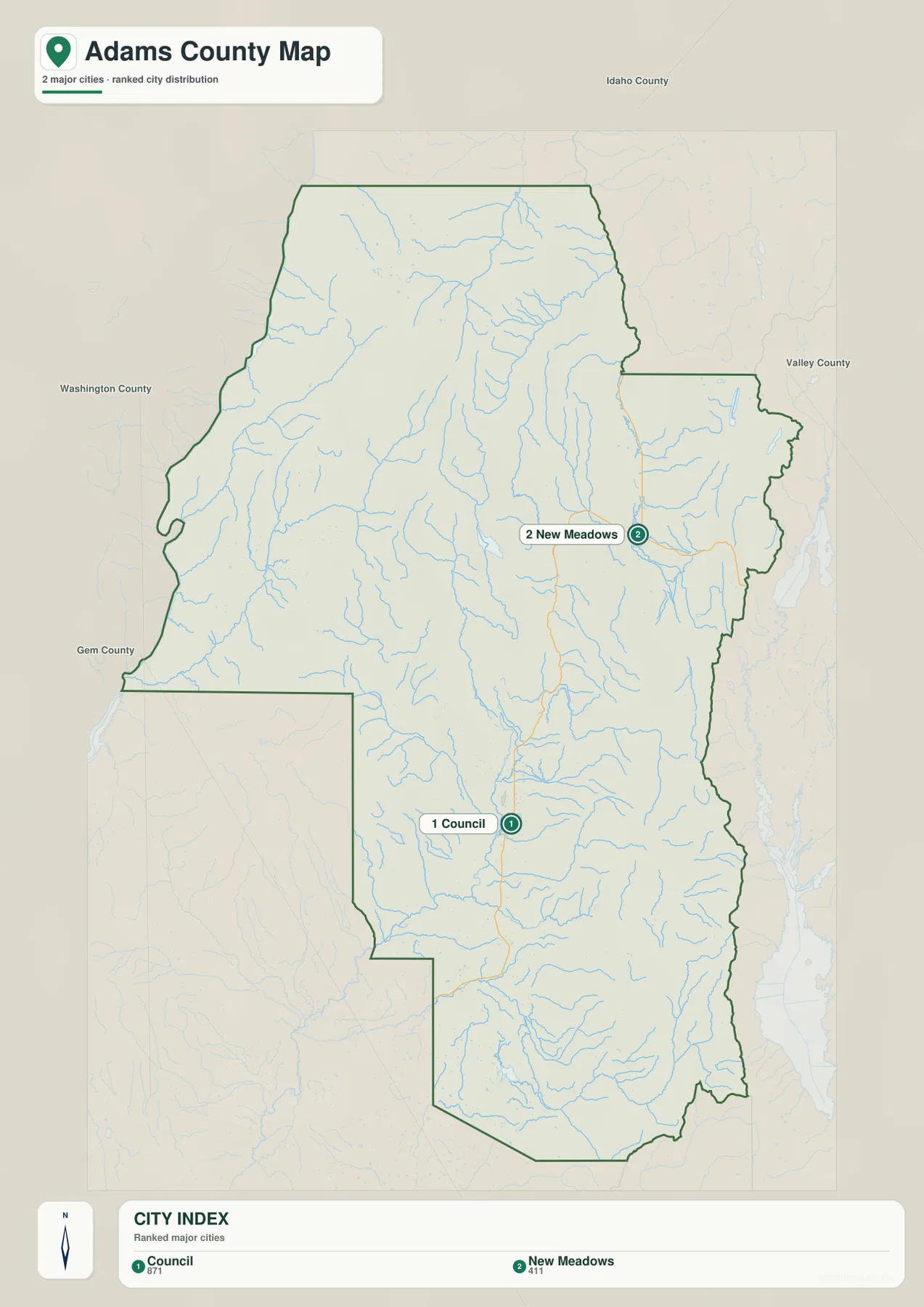
This sheet is most useful for orientation rather than street-level navigation. It shows where the two main labeled communities sit relative to the boundary, but it does not draw a straight-line distance connector between them. The visible separation should therefore not be mistaken for a road-mileage measurement. The general county map and elevation map explain why travel is less direct: roads bend around higher ground and tend to remain in lower corridors where valleys provide practical routes through the mountains.
An Irregular Boundary Framed by Winding Road Corridors
The general county map adds roads, selected outside places, and more regional context. Adams County does not form a tidy rectangle. Its western side bends repeatedly, the southwest contains a large stepped indentation, and the eastern boundary changes direction several times before reaching the New Meadows projection. Council appears near a cluster of roads in the southern interior, while the northern half contains a much sparser road pattern across broad mountain terrain.
Numbered road shields provide useful landmarks for following direction. A north–south route marked 95 is visible south of Council, and several numbered roads branch around Council and across the interior. Farther north and west, other numbered routes bend through the county instead of forming a grid. McCall appears outside the eastern boundary and Pinehurst appears beyond the north, giving the reader additional reference points for how the county fits into the surrounding region.
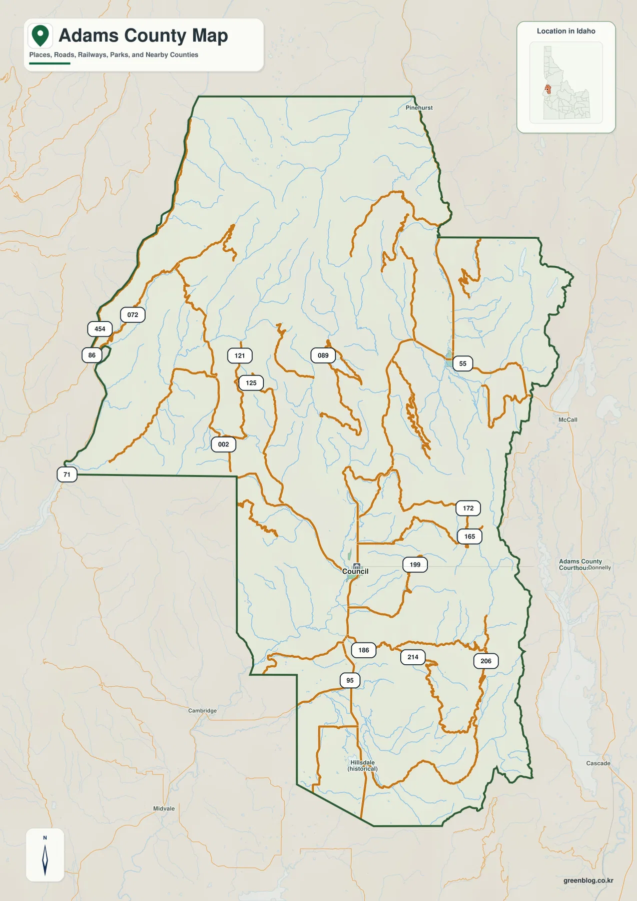
Many of those roads occupy the same broad low corridors that carry rivers and creeks, even when a route does not run immediately beside the water. In the north, roads become more widely spaced as the terrain grows higher and more rugged. Around Council, the lower valley allows several routes to meet and branch. The sheet is therefore well suited to regional orientation and route context, but it should not be used as a turn-by-turn navigation product or as evidence of legal road status, parcel access, or surveyed boundaries.
Weiser River Branches Link Central Valleys, Lakes, and Reservoirs
The water-and-terrain map is the most detailed sheet for the county’s drainage geography. West Fork Weiser River and Weiser River run through the central interior. East Fork Weiser River follows a more eastern corridor, while Middle Fork Weiser River and Little Weiser River become prominent across the southern half. The Little Salmon River occupies a separate north–south valley along the eastern side. Dozens of smaller tributaries descend from the ridges into these larger waterways, producing a dense network that mirrors the mountain relief underneath.
The named standing waters are spread across several different settings. Crystal Lake, Emerald Lake, and Black Lake sit close together in the northern mountains. Goose Lake and Fish Lake are separated farther east. Lost Valley Reservoir lies in the central part of the county near the West Fork Weiser River corridor, while Ben Ross Reservoir appears in the south near the Little Weiser River side. Seeing these features on one page makes it easier to distinguish high mountain lakes from reservoirs positioned in lower drainage areas.
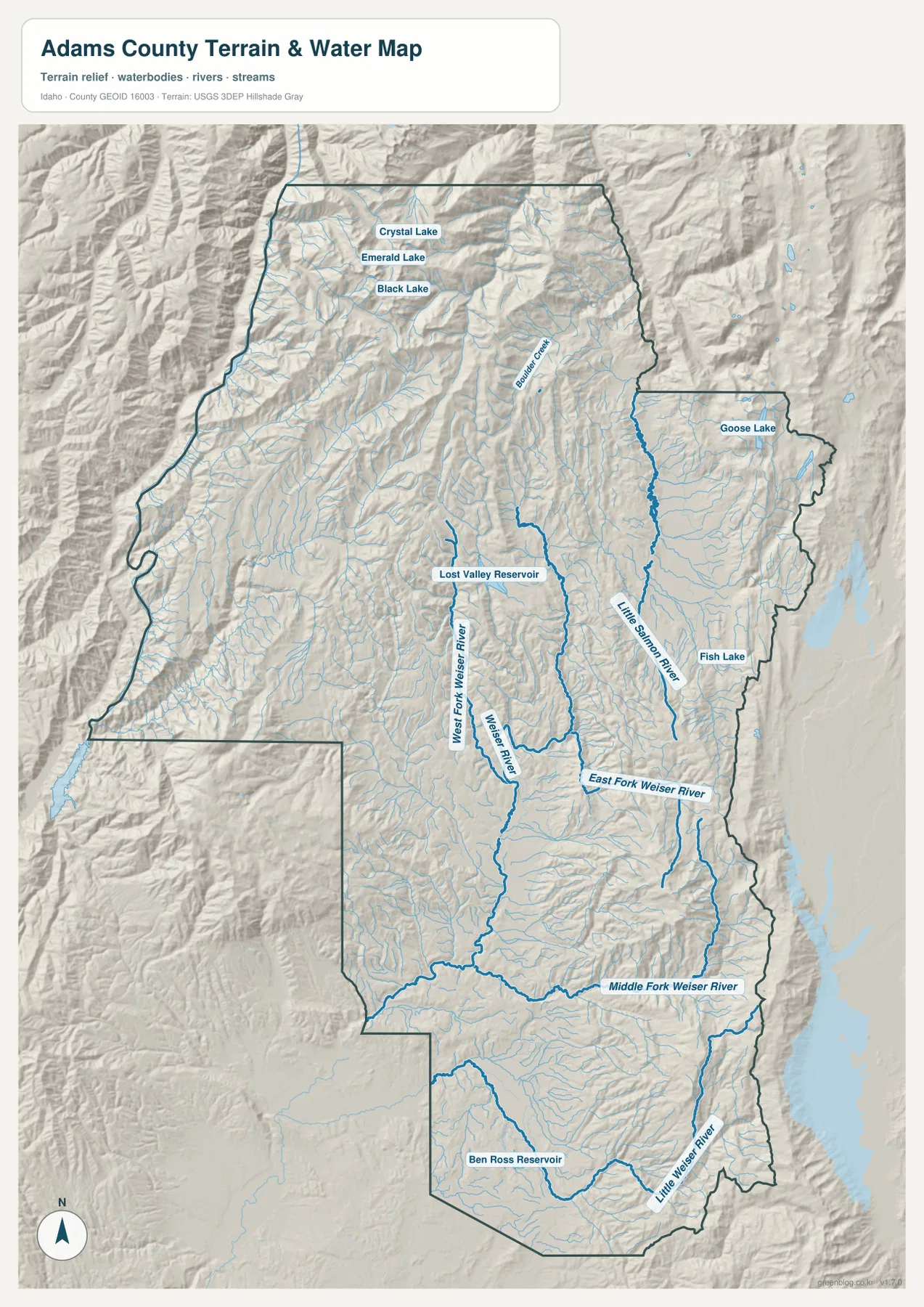
The shaded relief is especially helpful because the major river lines generally occupy the lower spaces between ridges. Fine tributaries spread uphill into smaller valleys, while the Little Salmon River is visually separated from the central Weiser system by higher terrain. This is a geographic water reference, not a flood map, fishing-access map, navigation chart, or legal water-boundary product. Its purpose is to show where named waters lie and how they relate to the county’s mountain valleys.
High Northern and Eastern Ridges Surround Lower Interior Valleys
The elevation map turns the county’s relief into an easy color comparison. Its annotation gives an actual range of about 444 to 2,708 meters and a mean of about 1,458 meters. Green shades mark lower ground, while tan, orange, and brown indicate increasingly high terrain. The highest concentrations of brown occur across the north and along portions of the eastern boundary. Lower green corridors extend through much of the central and southern interior, often following the same valleys identified on the water map.
The northern end appears especially rugged, with high ridges packed close together. Moving southward into the interior, broader green valleys open around the Weiser River system, although isolated ridges continue to divide one drainage from another. The eastern edge rises again in long mountain bands. The Little Salmon River corridor remains lower than the ridges beside it, and the New Meadows side sits within a valley pocket enclosed by higher terrain. The south is generally lower than the far north, but prominent high ridges return along the southeastern edge.
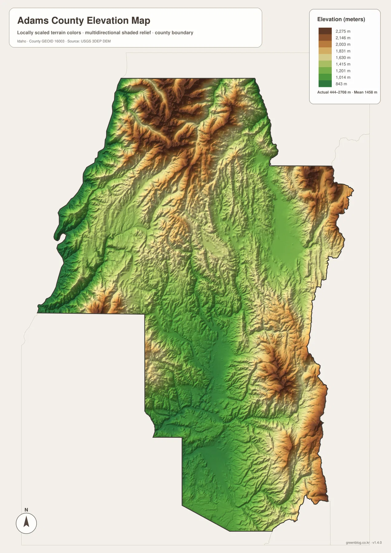
This relief helps explain both settlement and roads. Council occupies a broader lower area in the southern-central county, and New Meadows sits in another valley closer to the eastern mountains. Roads commonly follow those lower corridors rather than crossing the highest ridges directly. The colors are generalized for county-scale comparison, however, so they should not be treated as survey-grade elevations, trail profiles, engineering measurements, or precise readings for individual sites.
Which Map Works Best for Boundaries, Water, or Terrain?
Choose the general county map when you need the outline, road corridors, Council, and neighboring context on one page. The city map is cleaner when the main question is how Council and New Meadows are positioned within the county. Use the water-and-terrain sheet for the Weiser River branches, Little Salmon River, named lakes, and reservoirs. The elevation sheet is the most direct way to compare lower valleys with the high northern and eastern ridges.
For printing, the downloadable A3 JPG files preserve more detail than the browser previews. Fine streams, small road lines, terrain shading, and labels are easier to inspect at the larger size, and the four maps can be placed side by side in a report or classroom handout. They are regional reference maps rather than parcel, legal-survey, flood-determination, wilderness-navigation, or engineering products.
Frequently Asked Questions
Where are Council and New Meadows located within Adams County?
Council is in the southern half of the county in a broader valley where several routes and waterways come together. New Meadows is much farther northeast near the Valley County side. Mountain terrain and winding valleys separate them, so the map’s visual gap should not be read as a simple road-distance measurement.
Which named rivers, lakes, and reservoirs appear on the water map?
The map labels West Fork, East Fork, and Middle Fork Weiser River, the Weiser River, Little Weiser River, and Little Salmon River. It also shows Crystal Lake, Emerald Lake, Black Lake, Goose Lake, Fish Lake, Lost Valley Reservoir, and Ben Ross Reservoir.
What does the elevation map show about the county’s terrain?
It shows the highest terrain concentrated mainly in the north and along parts of the eastern side, with lower green valleys through the central and southern interior. The map annotation gives an elevation range of about 444–2,708 meters and a mean of about 1,458 meters; those figures are county-scale reference values rather than site-specific survey measurements.
Map File Information
Download the same four Adams County views shown on this page as high-resolution A3 JPG files in one ZIP for printing and offline use.
- File Type: ZIP containing four high-resolution A3 JPG files
Related Maps
Sources and References
The descriptions above are based first on the supplied Adams County maps and the features visibly labeled on them. The following official sources are useful for county information and the underlying types of boundary, water, and elevation data used in county-scale mapping.
- Adams County, Idaho – official county information and services
- U.S. Census Bureau TIGER/Line Shapefiles – county boundaries, roads, and geographic features
- USGS National Hydrography – rivers, streams, lakes, and related water features
- USGS 3D Elevation Program – national elevation and terrain data
Green Map creates custom-edited map images using open geographic data sources such as geoBoundaries, Natural Earth, OpenStreetMap, and government open data.
These maps are edited visual materials, not raw data files, and are provided for education, documents, presentations, and graphic reference.