If you are looking for a New Castle County Map that you can both read online and save for later use, this page provides four views of the county: a general county map, a city map, a water map, and an elevation map. A download box near the end of the article lets you download all four as high-resolution A3 JPG files in one ZIP, which is useful for printing, classroom work, reports, or side-by-side comparison.
New Castle County occupies the northern part of Delaware and stretches a long distance from the Wilmington–Newark area toward Middletown and Townsend. The northern section is visually dense, with many place names and major roads close together, while the southern section opens into a longer, narrower pattern with more space between towns. Christina River, Lums Pond, Delaware Bay, and the change in elevation from northwest to south add another layer to that north–south contrast.
Table of Contents
A dense northern cluster gives way to a long southern corridor
The general county map is the best place to understand the overall shape. Wilmington, Newark, Elsmere, Newport, and New Castle sit within a relatively compact northern area, with Arden shown near the top of the county. Wilmington lies toward the northeast beside major waterways, while Newark is farther west. New Castle is southeast of both, making it a useful reference point between the northern urban area and the rest of the county.
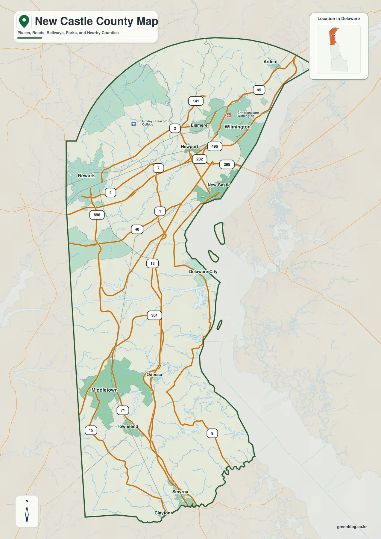
Farther south, Delaware City is followed by places such as Middletown, Odessa, Townsend, Smyrna, and Clayton. The names are not packed together as tightly as they are in the north, so the southern section feels more open on the page. The western edge is comparatively straight, while the eastern side bends around larger waterways and the bay. Seeing this elongated outline first makes it easier to interpret the road, water, and elevation maps that follow.
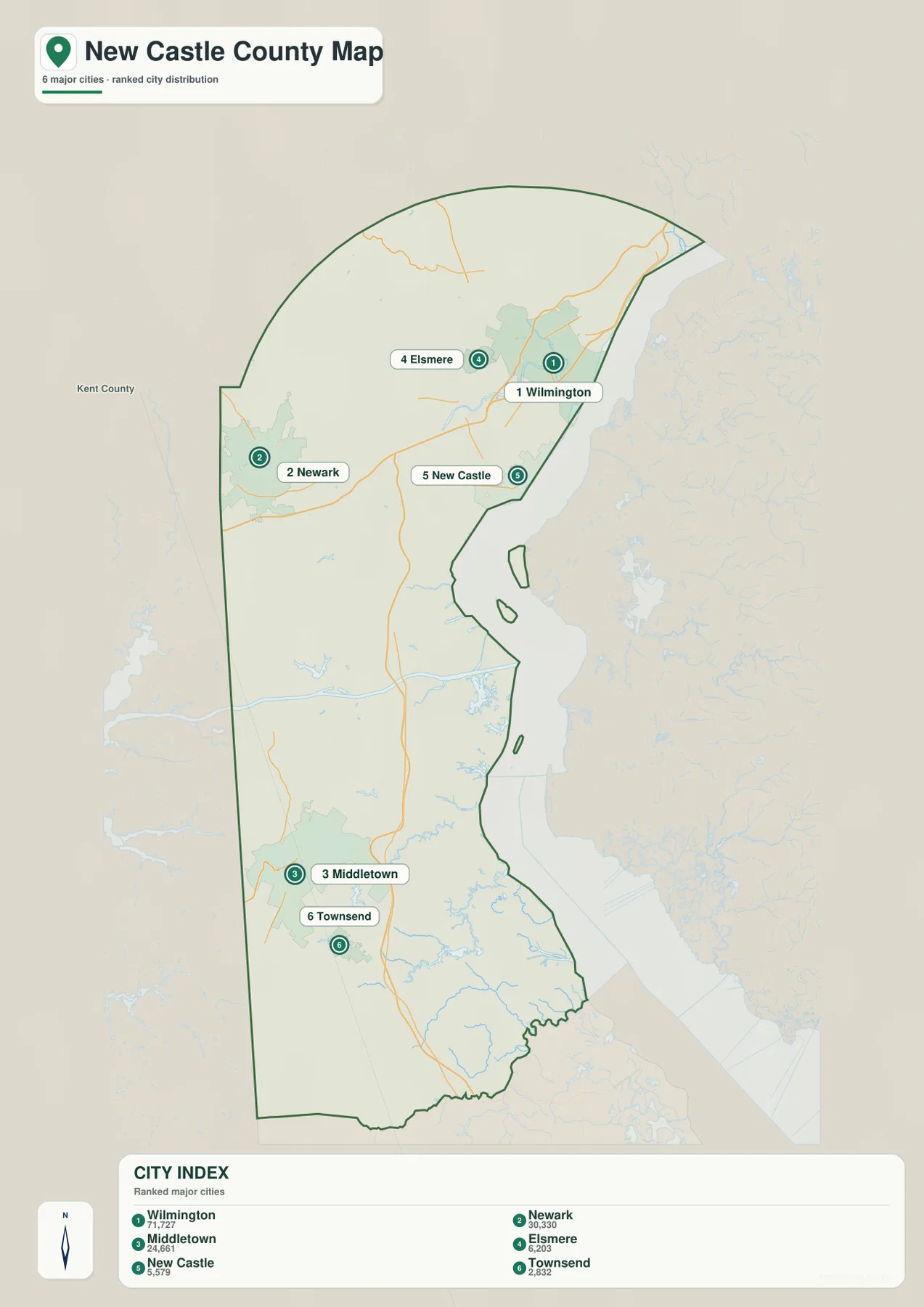
The simplified city map removes much of the road detail and emphasizes Wilmington, Newark, Middletown, Elsmere, New Castle, and Townsend. That makes it especially useful when the question is simply where the main places sit relative to one another. Wilmington and Elsmere are close in the northeast, Newark is farther west, New Castle lies to the southeast, and Middletown and Townsend are well to the south.
I-95 dominates the north while DE 1 and US 13 carry the map south
Road density is one of the clearest differences between northern and southern New Castle County. I-95 passes through the Wilmington and Newark area, and I-495 and I-295 branch near Wilmington. US 202 and DE 141 are also prominent around Wilmington, while the Newark side shows routes including DE 2, DE 4, DE 7, and DE 896. With so many major lines in a short distance, the northern road network naturally appears crowded.
South of New Castle, the pattern becomes simpler. DE 1 and US 13 follow the county’s long north–south direction and provide strong visual guides toward Middletown and the southern towns. US 40 crosses between the northern and central areas, while US 301 approaches from the west and continues toward the middle and south. Around Middletown, routes such as DE 71 and DE 15 add local detail without producing the same concentration of lines seen around Wilmington and Newark.
These maps are not a substitute for live navigation, but they are useful for explaining where the major corridors sit. A reader can quickly see why Wilmington and Newark function as the most road-dense part of the county and then follow the simpler route pattern toward Middletown and Townsend. For presentations or worksheets, the city map can be paired with the general map so that one image shows the place names clearly while the other supplies the transportation context.
Christina River, Lums Pond, and Delaware Bay reveal the county’s water side
The water map changes the emphasis from roads to rivers, creeks, reservoirs, and ponds. Christina River appears in the north near Wilmington, while Hoopes Reservoir is shown in the northwest. Farther south, Four Seasons Lake is labeled, and the central part of the county includes Lums Pond along with Long Creek and Dragon Creek. Features that seem like empty space on the road map become a web of named waterways on this version.
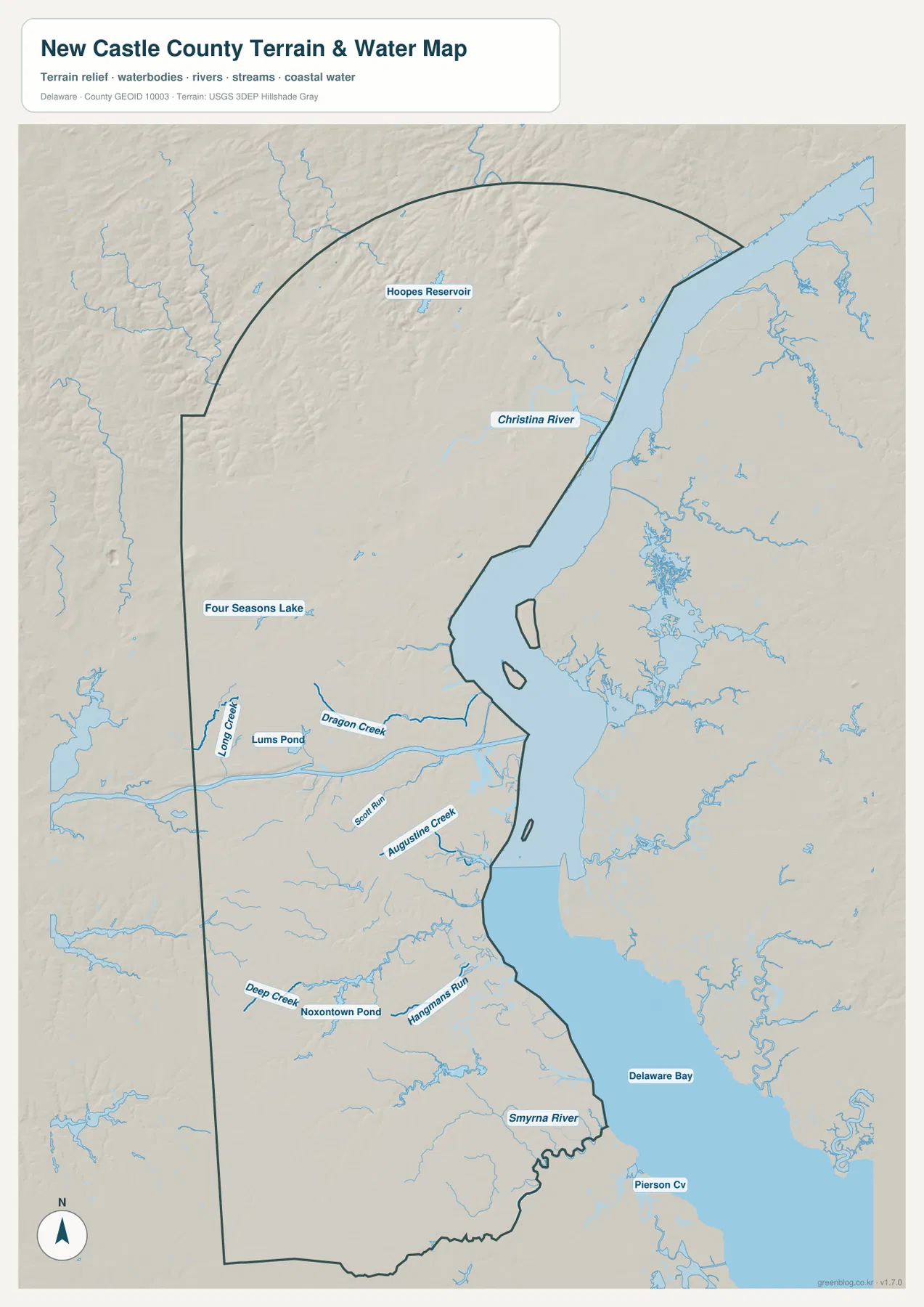
Moving toward the middle and south, the map also labels Scott Run, Augustine Creek, Deep Creek, Hangmans Run, Noxontown Pond, and Smyrna River. Delaware Bay forms the large water reference on the eastern side of the lower county. This version is useful when you need to locate a named stream or pond relative to a town, but it should not be used to determine flood zones, legal wetland boundaries, or water depth. Those questions require purpose-built official data.
Using the water and general maps together makes several relationships easier to explain. Christina River can be placed within the northern Wilmington area, Lums Pond can be seen in the central part of the county, and Smyrna River can be located much farther south. This is particularly helpful when a road name is not the most useful reference and a lake, river, or creek provides a clearer landmark.
Higher ground in the northwest fades into lower southern terrain
The elevation map shows a broad north–south change rather than street-level heights. Browns and tan shades are more common in the north and especially the northwest, indicating higher terrain relative to the rest of the county. The surface also appears more broken there, with shorter ridges and valleys. As the map moves toward Middletown and Townsend, greens become more widespread and the terrain appears lower and gentler.
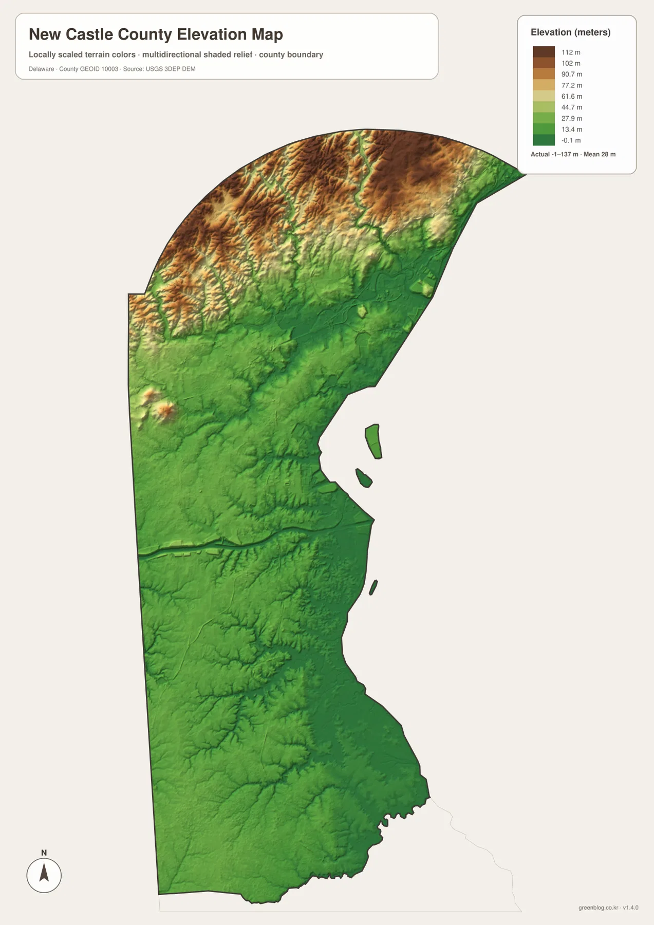
The legend is expressed in meters, but the map is most useful for comparing broad terrain differences rather than measuring the exact elevation of a building or road. When it is placed beside the general map, the Wilmington–Newark area and the Middletown–Townsend area can be compared in both location and relief. Adding the water map shows how rivers, creeks, and ponds fit within that changing terrain.
Choose the map according to the detail you need
For a first look, the general county map is usually the most practical because it combines boundaries, cities, major roads, and selected water features. It works well when you need to explain the county from Wilmington to Middletown without switching between several images. If the goal is only to compare where Wilmington, Newark, New Castle, Middletown, and Townsend sit, the simpler city map is easier to read at a glance.
The water map is the better choice for Christina River, Lums Pond, Smyrna River, and other named water features. The elevation map is useful when the question is why the northwest looks different from the lower southern section. Rather than asking one image to show everything equally well, use the version that puts the needed information in the foreground.
The WebP images on this page are convenient for quick viewing in a browser. When you need a larger image for printing or detailed inspection, use the A3 JPG files in the ZIP below. The archive includes one JPG for each of the four map types described on this page.
Frequently Asked Questions
Where are Wilmington and Newark in relation to each other?
Both are in the northern part of New Castle County, but Wilmington is farther east near major water while Newark is to the west. The general road map makes the difference clear because I-95 and the surrounding routes connect the two areas without placing them in the same location.
Which map is best for finding Lums Pond and Christina River?
The water map is the easiest choice for named water features. Christina River is shown in the north, Lums Pond appears in the central part of the county, and nearby creeks such as Long Creek and Dragon Creek can be viewed in the same context.
Does New Castle County change much in elevation from north to south?
Yes, at the county-wide scale the northwest is relatively higher, while the land becomes lower and gentler toward Middletown, Townsend, and the southern section. The elevation map is designed to show that broad contrast rather than exact site-level heights.
Map File Information
The ZIP contains the general, city, water, and elevation maps for New Castle County as four high-resolution A3 JPG files. Use them when you need a larger image for printing, class materials, reports, or detailed comparison.
- Included Files: 4 A3 JPG maps — general, city, water, and elevation
Related Maps
Sources and References
- New Castle County official website
- U.S. Census Bureau TIGER/Line boundary data
- USGS National Hydrography
- USGS 3D Elevation Program
Green Map creates custom-edited map images using open geographic data sources such as geoBoundaries, Natural Earth, OpenStreetMap, and government open data.
These maps are edited visual materials, not raw data files, and are provided for education, documents, presentations, and graphic reference.