Download the high-resolution JPG originals for this Washington County Colorado Map in the ZIP below. The maps cover Akron and Otis, the main highway and county-road pattern, Surveyor Creek and the Arikaree River system, and a broad elevation change from lower eastern plains to higher terrain in the southwest. WebP versions are provided for quick browsing, while the full-size JPG files are better for printing, detailed viewing, and offline reference.
The easiest way to orient Washington County is to start in the northern half, where Akron and Otis form the two ranked population centers. U.S. 34 links the general area between them, while long north-south roads extend into the much more sparsely settled southern plains. Washington County’s official site places the county courthouse in Akron, giving the town both an administrative role and a useful geographic reference point for reading the maps.
Table of Contents
Akron and Otis along the northern road corridor
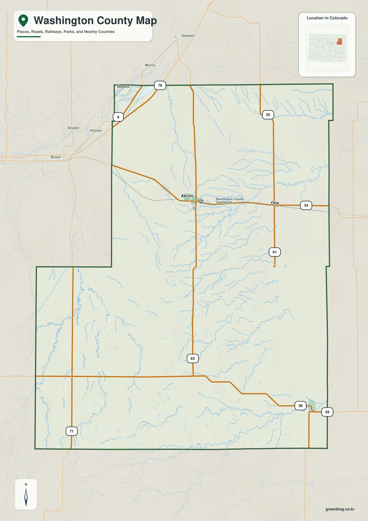
The county map places Akron in the north-central part of Washington County and Otis farther east. U.S. 34 provides the most obvious east-west reference through this settled band. Colorado 63 runs south from the Akron area, while routes 55 and 61 form a north-south line near Otis. Colorado 71 appears in the southwest, and U.S. 36 with Colorado 59 helps frame the southeastern edge. I-76 and U.S. 6 are visible beyond the small northwestern corner, adding regional context without becoming the county’s main internal road system.
The road pattern changes quickly south of Akron and Otis. Town labels become scarce, and longer straight roads cross a broad rural landscape. Small stream valleys interrupt that grid with irregular curves, showing that the plains are not perfectly flat even where the road network looks regular. The basic map is useful for locating communities, numbered roads, and the county boundary, but it is not intended for parcel lines or legal right-of-way work.
A ranked city map with Akron first and Otis second
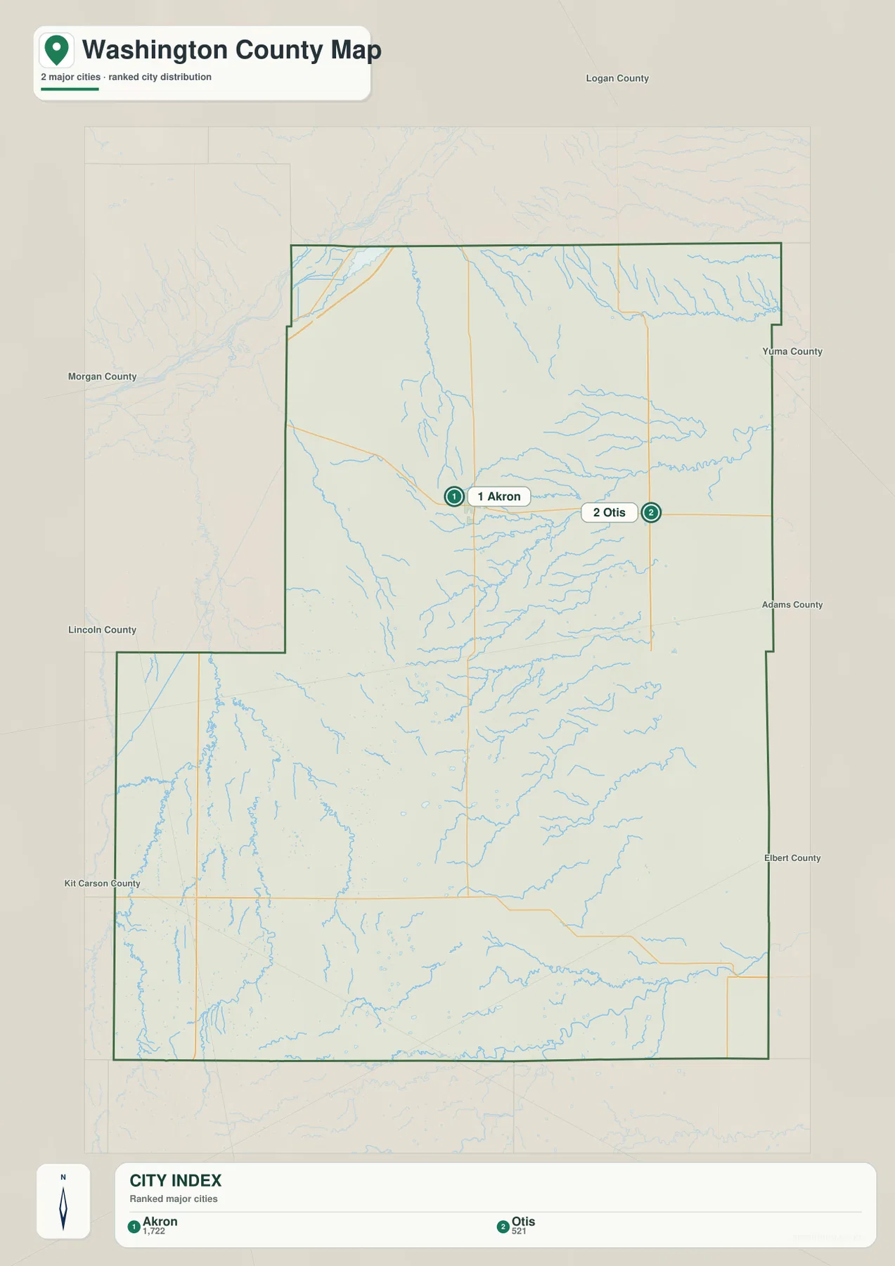
The city layer is a ranked distribution map rather than a connector-distance map. Its CITY INDEX lists Akron first and Otis second, and no straight-line mileage or driving distance is drawn between the two places. The map is therefore best used to compare where the county’s principal settlements sit rather than to estimate travel distance.
Both ranked communities are concentrated in the northern part of the county. Akron sits farther west, while Otis is closer to the eastern side, leaving a very large southern area without another ranked city marker. Labels for Logan, Yuma, Adams, Elbert, Kit Carson, Lincoln, and Morgan counties show Washington County’s position within Colorado’s eastern plains and help explain its long reach between several neighboring rural counties.
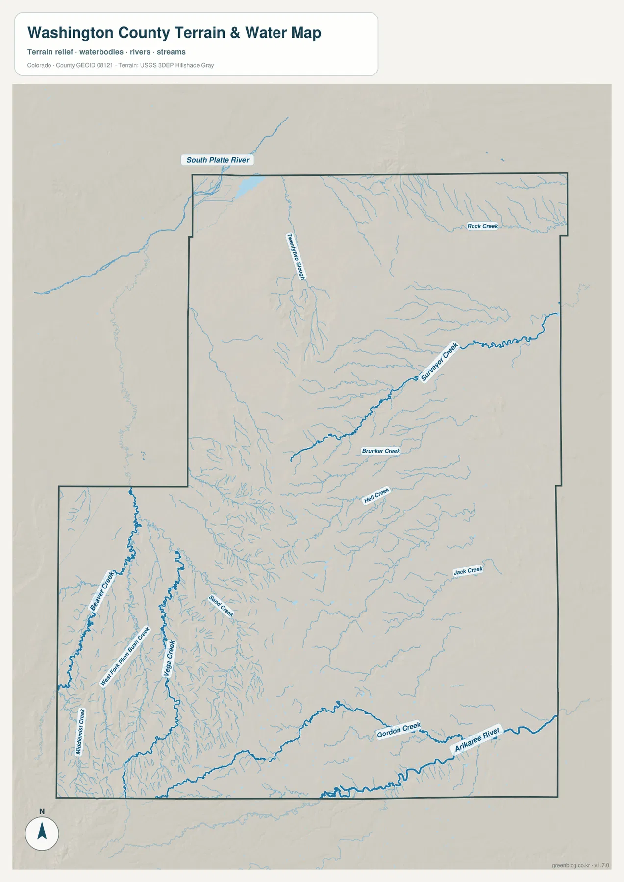
Surveyor Creek, Beaver Creek, and the Arikaree drainage
Surveyor Creek is one of the clearest named waterways in the north-central part of the water and terrain map. Rock Creek appears near the northeastern side, while Brunker Creek and Hell Creek occupy separate central drainage paths. Jack Creek is labeled farther southeast. Rather than one large river collecting nearly every tributary, Washington County shows a dispersed network of smaller plains streams spread across a wide area.
The southwestern portion contains a denser cluster of drainage lines. Beaver Creek, Middlemist Creek, Vega Creek, Sand Creek, and West Fork Plum Bush Creek cut through the higher ground there, creating a more dissected surface than the smoother eastern plains. The water layer becomes especially useful in this area because the creek network explains relief that is easy to miss on a road-only map.
Gordon Creek and the Arikaree River provide important references along the southern edge. The South Platte River is also labeled on the map, but it appears outside the county near the northwestern side rather than as Washington County’s central internal river. That distinction matters when reading the drainage geography: Surveyor Creek, Beaver Creek, Gordon Creek, and the Arikaree system are more directly tied to the county interior and boundary. The map is for general geographic reference and should not be used as a flood-hazard, water-rights, or legal channel-boundary source.
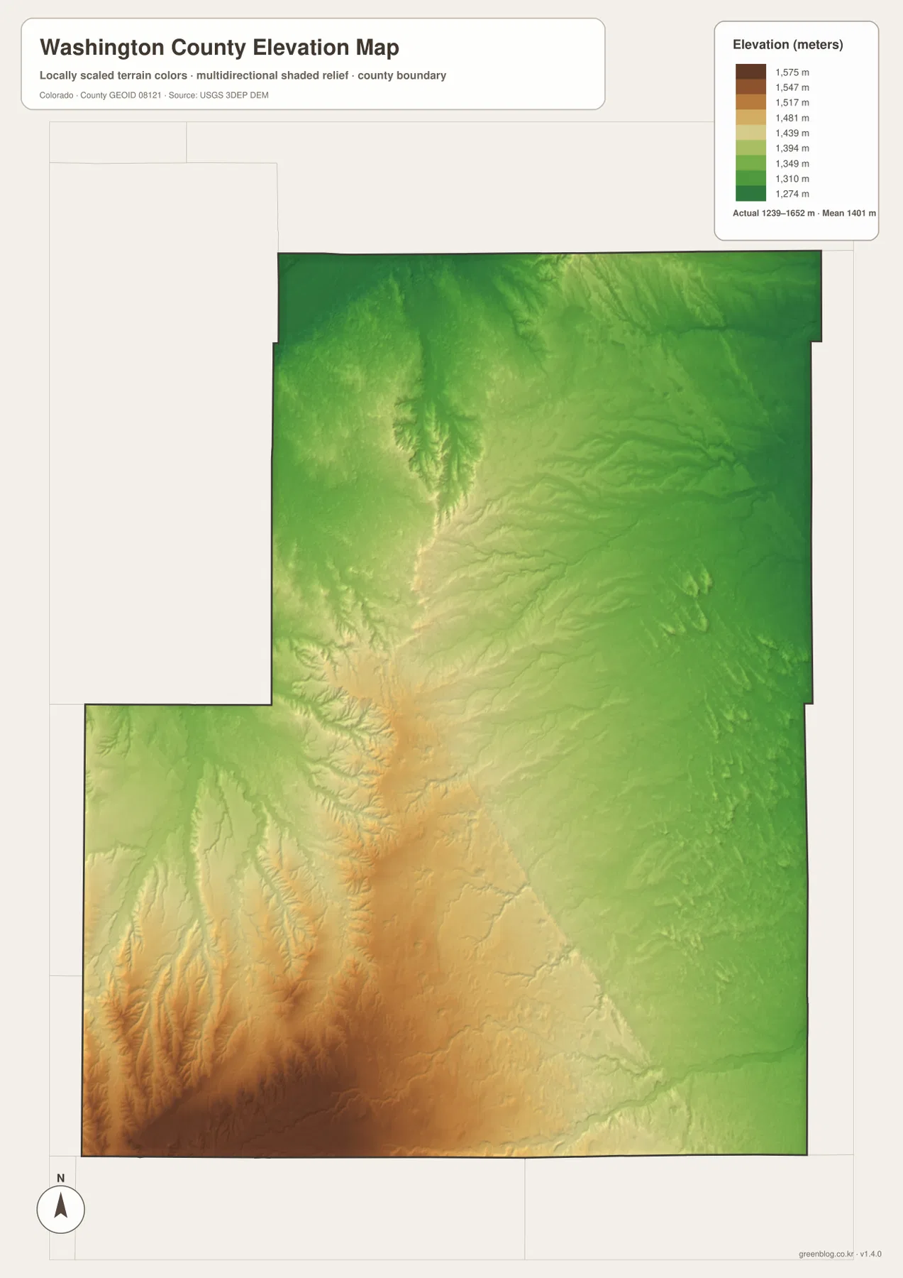
Elevation rises from about 1,239 to 1,652 meters
The elevation map reports an actual county range of about 1,239 to 1,652 meters, with a mean near 1,401 meters. The broadest lower terrain occupies the east and northeast, and the northern settlement band around Akron and Otis is generally lower than the southwestern corner. The plains are rolling rather than completely flat, with shallow drainage valleys creating subtle changes across the surface.
The southwest stands out as the county’s highest area. Warmer brown and tan colors cover a broad zone there, while numerous creeks cut into the elevated ground and form a more broken relief pattern. Central-western Washington County also contains local ridges and valleys, but the strongest concentration of high terrain remains in the southwest. This makes the contrast with the greener eastern plains easy to see even without steep mountain slopes.
Comparing the elevation and water maps helps explain why so many creek lines appear in the southwestern part of the county. The higher surface is divided by multiple small drainages, while the lower east has broader, smoother terrain. This elevation layer is intended for countywide comparison, not site-specific surveying, drainage engineering, road design, or construction. Those tasks require authoritative source data or professional measurements.
Akron as the county reference point and Otis as the eastern center
Washington County’s official maps page places the county courthouse in Akron and separately highlights both Akron and Otis. History Colorado notes that the Washington County Courthouse was completed in 1910 and served as the center of county government. Those references add useful context to the map, where Akron sits at a road junction and functions as the most convenient western reference for the county’s northern settlement band.
Otis is farther east along the same broad northern zone, where U.S. 34 and north-south roads provide access to surrounding rural areas. Reading Akron and Otis together is more informative than treating them as isolated town labels because their shared position contrasts sharply with the huge southern part of the county, where roads and drainage lines continue but ranked settlement markers disappear.
Choosing the map that answers your question fastest
Use the county map first when you need Akron, Otis, U.S. 34, numbered roads, and the county boundary in one view. The ranked city map is the simplest way to see that Akron and Otis are the two principal communities, but it does not provide mileage. Use the water and terrain layer for Surveyor Creek, Beaver Creek, Gordon Creek, and the Arikaree River. Choose the elevation map when the main question is how the lower eastern plains differ from the higher southwestern terrain.
For example, to understand the Akron–Otis settlement band, compare the county and city maps first. Add the water map when you want to see how small streams cross the open plains, and use the elevation layer to understand why the southwestern drainage network appears more deeply cut. The South Platte River label can also be checked on the water map to distinguish the nearby regional river from the creeks that actually cross Washington County itself.
Frequently Asked Questions
Does the city map show the distance between Akron and Otis?
No. The ranked city layer shows Akron first and Otis second, but it does not include connector lines, straight-line mileage, or driving distance. Use it to compare location and distribution rather than travel distance.
Does the South Platte River run through the middle of Washington County?
No. On the supplied water map, the South Platte River is shown outside the county near the northwestern side. Inside the county, Surveyor Creek, Beaver Creek, Sand Creek, Gordon Creek, and the Arikaree River system provide more direct drainage references.
Can the 1,239-to-1,652-meter elevation range be used for surveying?
No. The range is intended for broad geographic comparison between lower eastern plains and higher southwestern terrain. Surveying, engineering, construction, or site-specific elevation work should use authoritative source data or professional survey measurements.
Map File Information
The ZIP contains the original high-resolution JPG versions of the county, ranked city, water/terrain, and elevation maps shown on this page. Use the larger files for printing, detailed viewing, or offline reference.
- Included Files: Use only the versions confirmed in the article and supplied images
- File Type: Use the confirmed download contents
- Intended Use: Printing, education, presentations, and map-based projects
Related Maps
Sources and references
- Washington County official maps page – Akron, Otis, and county government location context
- Town of Akron official website – Akron community information
- History Colorado – Akron – Washington County Courthouse and local history
- U.S. Census Bureau TIGER/Line Shapefiles – county boundaries, roads, and place reference
- USGS National Hydrography – rivers, streams, and drainage features
- USGS 3D Elevation Program – elevation and terrain reference
Green Map creates custom-edited map images using open geographic data sources such as geoBoundaries, Natural Earth, OpenStreetMap, and government open data.
These maps are edited visual materials, not raw data files, and are provided for education, documents, presentations, and graphic reference.