Inyo County covers a vast part of eastern California between the Sierra Nevada and a series of desert mountain ranges that continue toward Death Valley and Nevada. Most established communities are concentrated along U.S. 395 in Owens Valley, where Bishop, Independence, Lone Pine, Olancha, and smaller places use the same long north–south corridor. Farther east and southeast, settlement becomes sparse and the map is dominated by mountain blocks, closed desert basins, Furnace Creek, Tecopa, and long state highways.
Download the original high-resolution A3 JPG files from this Inyo County Map page in one ZIP. The package contains a county reference map, city-distribution map, and terrain-and-water map. This bundle has no separate elevation map, so descriptions of high mountains and low desert basins rely on the visible relief shading and on verified information from Inyo County, the National Park Service, and other public agencies.
Table of Contents
Bishop is the only incorporated city, while Independence is the county seat
Inyo County has an unusual administrative pattern. The county’s official locations page identifies Independence as the Inyo County seat and lists the main county campus and administrative center there. The Planning Department separately states that Bishop is the only incorporated town in the county. That means the largest formal municipality and the seat of county government are not the same place.
The supplied city-distribution graphic contains a single ranked city: Bishop, with a printed map value of 3,778. That figure should be treated as the comparison value used in the supplied image rather than the newest population estimate. Current demographic work should use the Census or another official statistical source. The key map lesson is that Bishop is the one incorporated city in an otherwise largely unincorporated county.
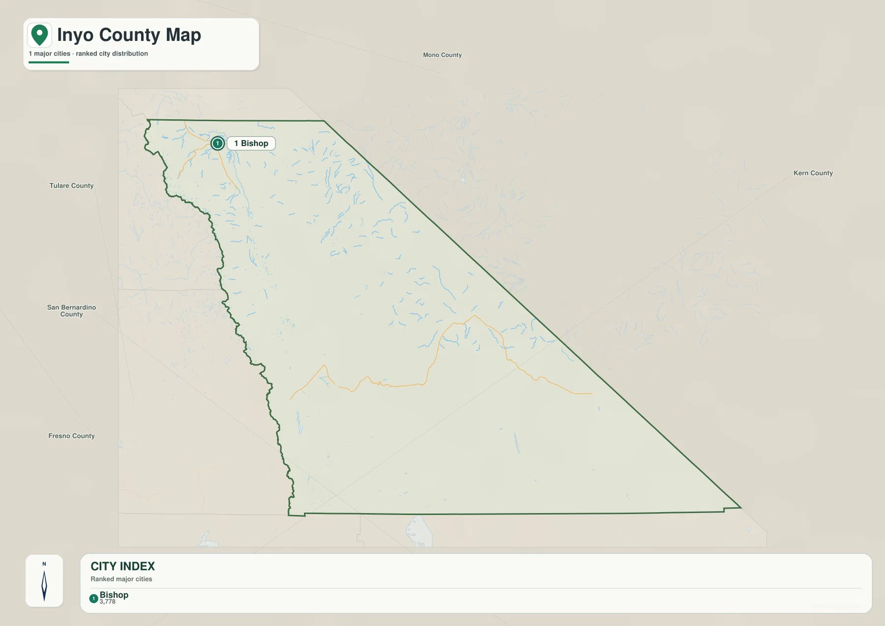
Independence, Lone Pine, Big Pine, Olancha, Tecopa, and other communities remain important for travel and local geography even though they are not incorporated cities. Inyo County’s official history says Independence has served as the county seat since 1866. For this reason, the ranked city view is useful for municipal status, but the reference map is much more important for understanding where people actually live and travel.
U.S. 395 ties the Owens Valley communities together from north to south
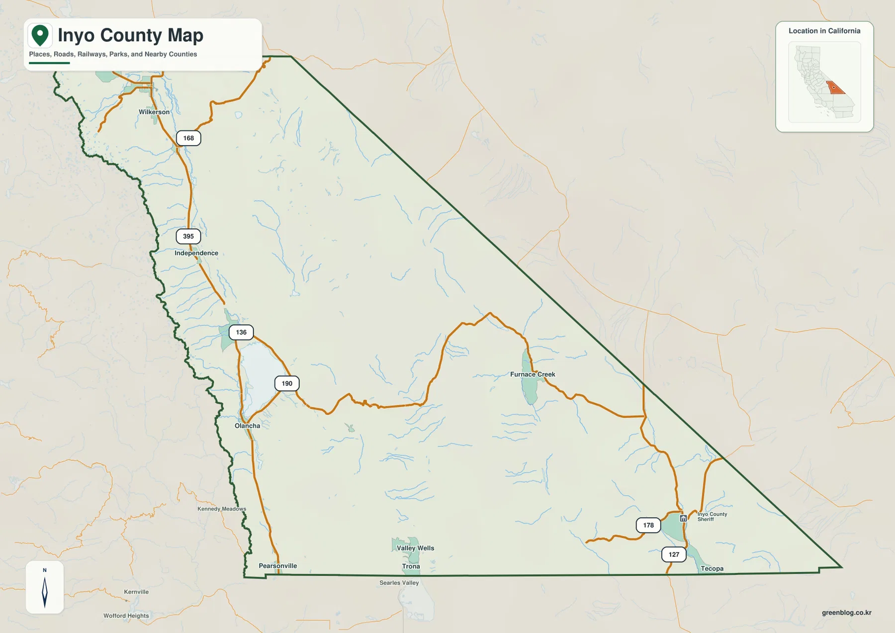
U.S. 395 is the most important transportation reference on the western side of the county. The reference map shows Independence, Olancha, and Pearsonville close to this long north–south road, with the corridor continuing toward Bishop to the north. Inyo County’s regional transportation plan describes U.S. 395 as the primary roadway serving most of the county’s population.
The highway follows Owens Valley, a long trough between the high Sierra Nevada on the west and the Inyo and White Mountains on the east. Because the valley provides one of the broadest continuous travel corridors in the county, many communities line up along or near the same route. Thinking from Bishop south through Independence and Lone Pine toward Olancha is much easier than trying to memorize the county’s enormous irregular outline.
U.S. 395 also connects several important historical and public sites. The National Park Service places Manzanar National Historic Site on the west side of the highway, about nine miles north of Lone Pine and six miles south of Independence. That relationship makes the road more than a transportation line: it links the county seat, major valley communities, and a nationally significant historical landscape within the same corridor.
State Route 190 leaves Owens Valley for Furnace Creek and Death Valley
Near the south-central part of the reference map, State Route 190 breaks away from the U.S. 395 side and heads east toward Furnace Creek. The route crosses broad desert terrain and mountain passes before reaching the heart of Death Valley. Furnace Creek is one of the clearest named places in the eastern interior and provides a useful landmark in an area with very few conventional towns.
The National Park Service also directs travelers from Lone Pine into Death Valley by taking CA 190 east. Once inside the park, roads follow valleys and passes between mountain ranges rather than a simple north–south urban corridor. This makes the eastern county read very differently from Owens Valley: road geography is controlled by large desert basins and mountain barriers.
Tecopa appears near the southeastern edge close to State Routes 127 and 178. This part of the county is far removed from Bishop and Independence and lies close to Nevada and San Bernardino County. Inyo County’s official history describes the county as California’s second largest by area, which helps explain why these communities can be separated by such long distances within a single county.
The Owens River and Tinemaha Reservoir organize the western valley water system
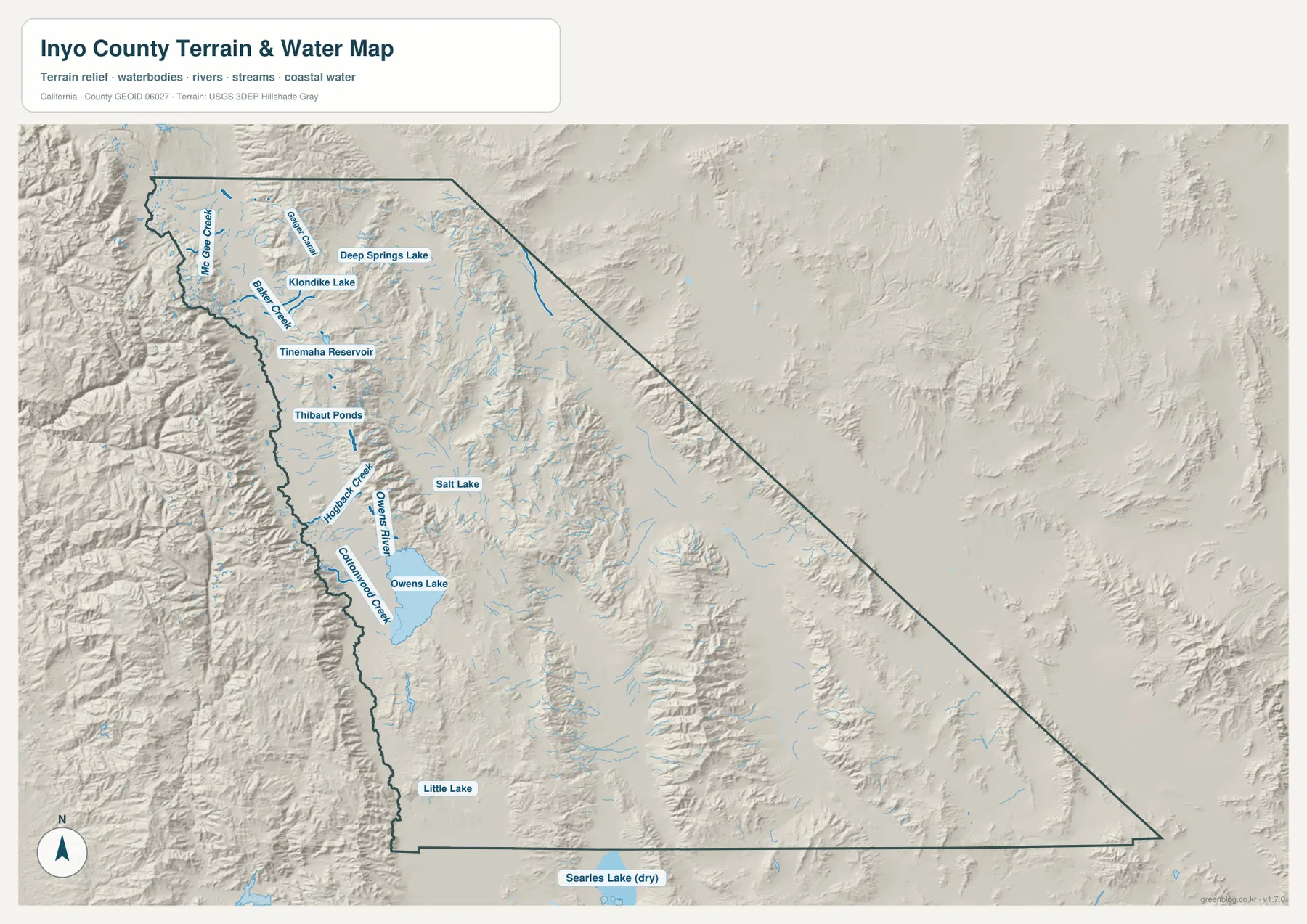
The Owens River is the strongest continuous water feature on the western side of the terrain map. Mountain creeks descend from the surrounding ranges and reach the valley floor, while the Owens River continues generally south through the long basin toward Tinemaha Reservoir and Owens Lake. The river occupies the lower valley between steep mountain fronts, which makes its course easy to relate to the U.S. 395 settlement corridor.
Tinemaha Reservoir provides a useful midpoint on the water map. North of the reservoir, Baker Creek and Goodale Creek descend from the mountain side, while Thibaut Ponds and other water features appear farther south. This pattern makes clear that Owens Valley is not simply a dry desert trough. Snowmelt streams, the main river, reservoirs, ponds, and managed water channels all occupy the same long valley floor.
The Inyo County Water Department monitors hydrology, soil water, and vegetation in Owens Valley and works under the Inyo/Los Angeles Long-Term Water Agreement. Its role reflects how important water management is in a county where a narrow populated valley depends on mountain runoff, groundwater, and managed river systems within an extremely dry regional climate.
Owens Lake marks a broad low basin at the southern end of Owens Valley
Owens Lake is one of the largest labeled water features on the western half of the terrain map. The Owens River approaches from the north, while Cottonwood Creek, Hobart Creek, and other smaller drainages descend toward the basin from the surrounding mountains. Compared with the steep ridges immediately to the west and east, the lake occupies a much broader and flatter valley floor.
Modern Owens Lake is also a heavily managed landscape. The Los Angeles Department of Water and Power operates a major dust-mitigation program using methods such as shallow flooding, managed vegetation, gravel, and other surface treatments. The county-scale map does not show those treatment areas or current water depth, but it correctly identifies Owens Lake as a major geographic feature in the southern Owens Valley.
Little Lake is labeled farther south near the lower end of the county’s western corridor, while Searles Lake (dry) appears just beyond the county boundary. That sequence helps show how Owens Valley grades into increasingly arid closed basins toward the south. A mapped lake name should not be taken to mean that a basin is always filled with open water, so current conditions should be checked separately when they matter.
Deep Springs Lake and Salt Lake show that the eastern desert is divided into separate basins
Eastern Inyo County is not one continuous flat desert. The terrain map labels Deep Springs Lake and Klondike Lake in the northeastern interior and Salt Lake farther south, each occupying a separate basin between mountain ranges. Unlike the long Owens River corridor, these areas have shorter local drainages and fewer continuous streams linking one basin to the next.
This difference is also visible on the reference map. Large community labels are scarce, and long highways cross broad areas of rugged relief before reaching Furnace Creek or Tecopa. Inyo County’s official background information notes that more than ninety percent of the land is owned or managed by public agencies, which helps explain why so much of the map is dominated by parks, forests, desert, and other sparsely developed land rather than city grids.
The terrain-and-water image is a county-scale geographic reference, not a road-status, flood-hazard, drinking-water, or backcountry-navigation map. Death Valley National Park warns that weather can quickly affect road conditions and that detailed current maps should be used for park travel. For actual desert trips, always check current National Park Service and county road information rather than relying on this overview map alone.
Mount Whitney and Badwater Basin show the county’s extraordinary vertical range
There is no numeric elevation layer in this package, but Inyo County has one of the most dramatic elevation ranges in North America. A 2026 Inyo County quality-assurance plan lists Mount Whitney at 14,505 feet as the county’s highest point and Badwater Basin at 282 feet below sea level as its lowest. The National Park Service identifies Badwater as the lowest point in North America.
Mount Whitney rises from the Sierra Nevada west of Owens Valley, while Badwater lies far to the east in Death Valley. The supplied relief map does not label every peak, but the rough mountain shading on both sides of Owens Valley and across the desert ranges makes the physical contrast unmistakable. Few county maps contain such an extreme combination of high alpine terrain and below-sea-level desert basin.
Precise hiking or elevation work requires dedicated topographic information. The U.S. Forest Service’s Mount Whitney Trail material identifies the summit at 14,505 feet and provides separate trail and permit guidance. The maps on this page are intended for county-scale orientation rather than route finding on a mountain or measuring exact elevations.
Use U.S. 395 and Route 190 as two simple guides through the county
A practical first pass is to find U.S. 395 in Owens Valley. Use Bishop and Independence as northern references, then continue south toward Lone Pine, Olancha, and the lower valley. On the water map, connect that same corridor with the Owens River, Tinemaha Reservoir, and Owens Lake. Roads and water then fit into one understandable valley rather than appearing as separate layers.
Next, leave Owens Valley on State Route 190 and move east toward Furnace Creek and Death Valley. The southeastern Tecopa area can be located with Routes 127 and 178. Separating the county into a populated U.S. 395 valley corridor and a much broader Route 190/Death Valley desert region makes the enormous county easier to understand without memorizing every minor road or basin.
Choose the file according to whether you need communities, roads, or desert water geography
The county reference map is the best starting point for Bishop, Independence, Olancha, Furnace Creek, Tecopa, major highways, and the county boundary. The city-distribution graphic answers the narrower question of where the county’s one incorporated city is located. The terrain-and-water map provides the strongest view of the Owens River, Tinemaha Reservoir, Owens Lake, Deep Springs Lake, smaller creeks, and the mountain-and-basin structure of the desert interior.
For teaching or regional explanation, the reference and terrain maps work especially well together. Independence and Olancha can be connected with U.S. 395 and the Owens River–Owens Lake corridor, while Furnace Creek illustrates the shift to the huge Death Valley side of the county. The city map adds one particularly useful administrative fact: Bishop is the only incorporated city even though Independence is the county seat.
Each downloadable JPG measures 3638 × 2572 pixels and is suitable for A3 landscape printing, enlarging small place labels, or placing a map in a report or classroom handout. Keep the original aspect ratio when resizing so roads, streams, basin outlines, and the county boundary are not distorted. Printer margins vary, so checking one test page before a larger print run is useful.
Frequently Asked Questions
Is Bishop or Independence the county seat of Inyo County?
Independence is the county seat. Bishop is the county’s only incorporated city, but the main county government campus and administrative center are in Independence. The two places therefore serve different municipal and administrative roles.
How are the Owens River and Owens Lake connected on the map?
The Owens River runs south through Owens Valley, passes through the Tinemaha Reservoir area, and continues toward Owens Lake. Numerous smaller mountain creeks also descend into the valley, making the river–reservoir–lake corridor a strong reference for western Inyo County.
Does this download include a separate elevation map?
No. This Inyo County package contains the county reference map, city-distribution map, and terrain-and-water map. The huge difference between the Sierra high country and Death Valley lowlands can be discussed from relief shading and official sources, but no separate numeric elevation map is included.
Map File Information
The ZIP contains the original Inyo County reference, city-distribution, and terrain-and-water maps as high-resolution JPG files.
- Included Files: County reference map, city-distribution map, terrain-and-water map
- Printable Size: 3638 × 2572 pixels each
- File Type: Three high-resolution JPG files in one ZIP archive
Related Maps
Sources and References
- Inyo County – History – Official county information on Independence as county seat, county size, and historical background.
- Inyo County – County Locations – Official locations for the county government campus and public offices in Independence, Bishop, Lone Pine, and Tecopa.
- Inyo County Water Department – Official information on hydrology, groundwater, vegetation monitoring, and Owens Valley water management.
- National Park Service – Death Valley Directions – Official access information for CA 190, Furnace Creek, and major Death Valley routes.
- LADWP – Owens Lake Dust Mitigation – Official information on current dust-control and water-management work at Owens Lake.
Green Map creates custom-edited map images using open geographic data sources such as geoBoundaries, Natural Earth, OpenStreetMap, and government open data.
These maps are edited visual materials, not raw data files, and are provided for education, documents, presentations, and graphic reference.