Imperial County occupies California’s far southeastern corner, where a broad irrigated valley sits between desert mountains, the Salton Sea, the Colorado River, and the international border with Mexico. El Centro, the county seat, is the main urban center in the southern Imperial Valley. Calexico lies directly on the Mexican border, Brawley is farther north, and Calipatria approaches the southeastern side of the Salton Sea. The eastern county reaches Arizona along the Colorado River, while the western edge rises toward dry mountain country near San Diego County.
Download the original high-resolution A3 JPG files from this Imperial County Map page in one ZIP. The package contains a county reference map, ranked city-distribution map, and terrain-and-water map. There is no separate elevation map in the supplied package, so terrain descriptions stay with the visible relief shading and with verified Imperial County geographic information.
Table of Contents
El Centro is the county seat, while Calexico sits directly on the Mexico border
Imperial County’s 2025 Emergency Operations Plan identifies El Centro as the county seat. On the reference map, El Centro occupies the largest developed area in the southern valley. The City of Imperial is immediately north, Seeley lies to the west, and Heber and Calexico extend south toward the international boundary. This cluster contains the densest road and settlement pattern visible anywhere in the county.
Calexico occupies a very different geographic position because its southern edge meets Mexico and the city of Mexicali. Highways 98 and 111 and Route 7 are visible around the border area. Heber fills part of the space between Calexico and El Centro, so the southern valley reads as a connected chain of communities even though each has a separate local identity.
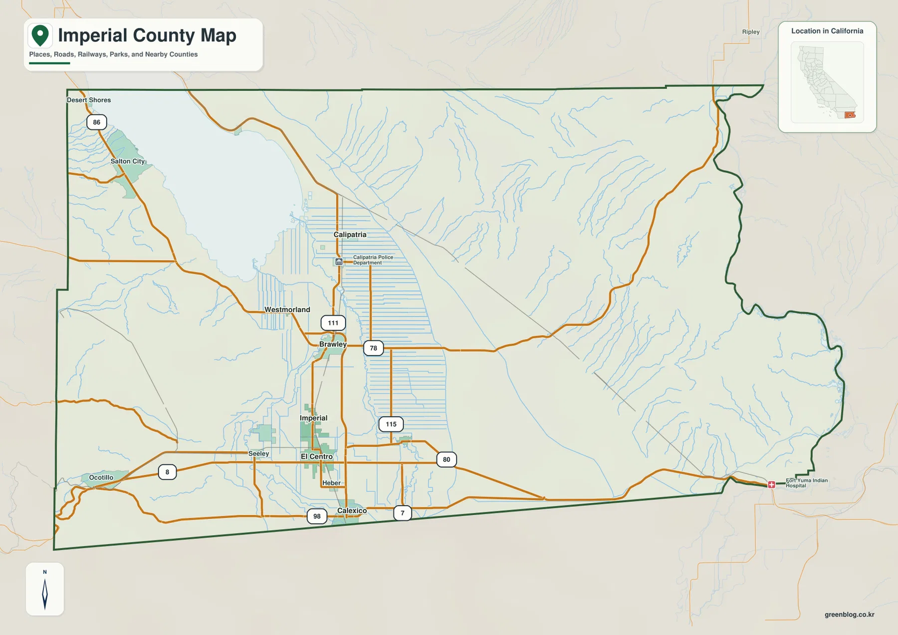
Interstate 8 provides the strongest east–west transportation reference across the southern county. It runs through the Seeley–El Centro area, heads west through Ocotillo toward San Diego County, and continues east across desert terrain toward Yuma, Arizona. State Route 111 works more as a north–south guide through the populated valley, making the two roads useful for separating the county into a simple cross-shaped travel framework.
Brawley, Westmorland, and Calipatria line the agricultural plain south of the Salton Sea
Brawley is the main northern city visible in the central Imperial Valley. State Routes 111 and 78 meet in the area, and Westmorland lies to the west. Calipatria is farther north, much closer to the southeastern shore of the Salton Sea. The straight canal and field pattern around these cities is one of the most distinctive features on the reference map.
The California Salton Sea Management Program describes the Salton Sea as the state’s largest lake by surface area, extending between the Coachella Valley and Imperial Valley. Agricultural drainage from Imperial County is one of its major sources of inflow. On the map, the irrigated plain north of Brawley and Calipatria reaches directly toward the lake, providing a clear visual connection between the farm belt and the Salton Sea.
Salton City and Desert Shores sit on the western side of the lake along State Route 86. They are separated from the central valley cities by drier land and a different road pattern. This western Salton Sea edge helps show that Imperial County is not one uninterrupted agricultural plain; desert and mountain terrain surround the intensively irrigated center.
El Centro, Calexico, and Brawley lead the ranked city distribution
The supplied city-distribution graphic ranks six major cities. El Centro is shown first at 44,240, Calexico second at 38,585, and Brawley third at 27,283. Imperial follows at 21,430, Calipatria at 6,548, and Holtville at 5,617. These values are comparison figures printed on the supplied image rather than the newest Census estimates, so current demographic work should use an official statistical source.
The geographic pattern is more useful than the ranking alone. El Centro and Imperial are almost adjacent in the southern center of the valley. Calexico is on the border, Brawley is to the north, Calipatria is farther north toward the Salton Sea, and Holtville sits east of El Centro in irrigated farmland. Almost all of the ranked urban population is concentrated in the same central agricultural lowland.
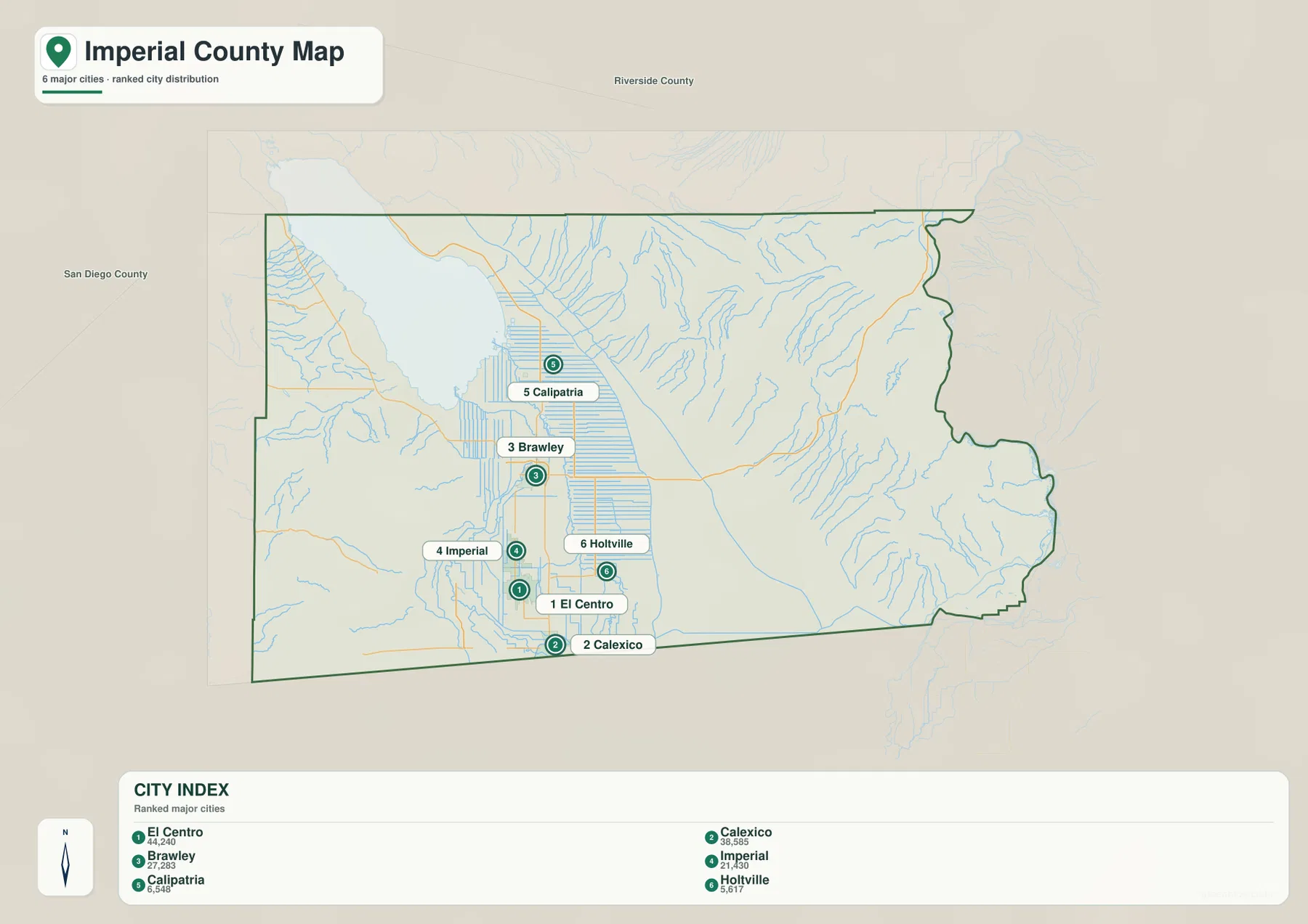
Imperial County’s 2025 Emergency Operations Plan lists seven incorporated cities: El Centro, Brawley, Calexico, Calipatria, Holtville, Imperial, and Westmorland. The supplied ranked graphic shows six of them, so Westmorland is not an error or missing county identity. The broader reference map is the better choice for Westmorland and for unincorporated communities such as Heber, Seeley, Ocotillo, Desert Shores, and Salton City.
The All-American Canal carries Colorado River water across the southern desert
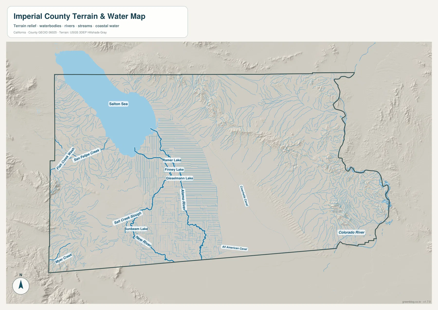
One of Imperial County’s defining water features is not a natural river but a major irrigation canal. The Imperial Irrigation District states that the All-American Canal carries Colorado River water to the Imperial Valley and became the sole water source for valley residents and farmland in 1942. On the terrain-and-water map, the canal runs westward across the southern part of the county close to the Mexico border.
The importance of that canal becomes clear when it is compared with the surrounding terrain. Imperial County economic-development material describes roughly three-quarters of the county as desert land made up of sand and rugged mountains, while the central valley supports a large irrigated agricultural area. The dense straight-line water network around El Centro, Brawley, Imperial, and Calipatria is therefore a major human-made contrast with the dry terrain outside the farm belt.
IID explains that several major canals branch from the All-American Canal, including the East Highline, Central Main, and Westside Main systems. The supplied map does not label every branch by name, but it clearly shows a dense grid of canals and drains across the central agricultural plain. That network is one of the easiest visual clues for distinguishing cultivated Imperial Valley from the undeveloped desert around it.
The Alamo and New rivers carry valley drainage north toward the Salton Sea
The Alamo River is labeled near the center of the terrain map, running generally north through the irrigated valley toward the Salton Sea. The New River lies farther west, entering the southern valley near the Calexico–El Centro area and continuing north toward the lake. Their long, lowland courses differ sharply from the short, branching desert washes visible in the surrounding mountains.
California’s Salton Sea program identifies agricultural drainage from the Imperial Valley, together with the New and Alamo river systems, as major sources of inflow to the lake. The Salton Sea has no natural outlet, so changes in inflow, salinity, and exposed shoreline have become major environmental concerns. This county map does not show water quality, but it does make the basic physical connection between irrigated farmland, the two rivers, and the Salton Sea easy to understand.
Several smaller water bodies appear south of the Salton Sea, including Ramer Lake, Finney Lake, and Gieselmann Lake. Sunbeam Lake is shown farther south near the New River side. These smaller features provide useful landmarks within the agricultural lowland, but the terrain-and-water map should not be used as a flood-hazard, water-quality, legal-boundary, or navigation product.
The Colorado River forms the Arizona side and supplies the valley’s canal system
The Colorado River is the clearest natural boundary on the far eastern edge of Imperial County. County regional material describes the eastern border as being marked by the river, with Arizona beyond it. The terrain map shows the Colorado following the irregular eastern boundary, while the reference map places Yuma immediately across the state line.
The river also connects directly to the county’s agricultural geography because it supplies the All-American Canal. Reading the map from east to west creates a simple water story: Colorado River water enters the canal system, travels across desert country, and supports the dense irrigated valley around El Centro, Holtville, Imperial, Brawley, and Calipatria. Few counties show the relationship between a major river and a human-made agricultural water network as clearly at this scale.
The reference map also labels the Fort Yuma Indian Hospital near the eastern edge and shows Interstate 8 heading toward Yuma. This part of the county contains far fewer large settlements than the central valley. Desert terrain occupies most of the space between the irrigated farm belt and the Colorado River corridor.
The irrigated valley is surrounded by low basins, desert slopes, and rugged mountains
There is no separate elevation map in this package, but the relief shading makes the contrast across Imperial County unmistakable. The central agricultural zone around El Centro and Brawley is broad and smooth, while the western Ocotillo side and much of the eastern county contain much stronger mountain relief. The Salton Sea occupies an exceptionally low basin at the northern end of the valley.
Imperial County’s 2025 Emergency Operations Plan reports terrain ranging from about 235 feet below sea level at the Salton Sea to 4,548 feet at Blue Angel Peak. Those figures come from the county document, not from a separate elevation layer in this map package. The supplied terrain image is best used to compare broad lowland and mountain areas rather than to measure exact elevation.
West of El Centro, Interstate 8 passes Seeley and then Ocotillo before entering the mountain corridor toward San Diego County. Around the western Salton Sea, Desert Shores and Salton City sit between the lake and nearby desert slopes. In the east, another large desert zone separates the agricultural valley from the Colorado River. The irrigated center therefore appears almost like a geometric island of canals and fields within much drier land.
Start at El Centro, then read north to the Salton Sea and east to the Colorado River
A practical first pass begins at El Centro. Follow State Route 111 south to Calexico and north through Brawley toward Calipatria. Then use Interstate 8 to establish the county’s southern east–west direction from Ocotillo through El Centro toward Yuma. This gives the main city and highway framework before the more complex water network is added.
Next, switch to the terrain map and locate the Salton Sea. Trace the Alamo River and New River south into the Imperial Valley, then follow the All-American Canal east toward the Colorado River. This sequence links the lake, drainage rivers, farm belt, canal system, and major boundary river without requiring every small canal or desert wash to be memorized.
Choose the map according to whether you need cities, the border, or the irrigation-water network
The county reference map is the best starting point for El Centro, Calexico, Brawley, Calipatria, Holtville, Salton City, highways, and the Mexico–Arizona edges of the county. The ranked city map is useful when the relative scale and location of the six largest mapped cities are the main questions. The terrain-and-water map provides the strongest view of the Salton Sea, Alamo River, New River, All-American Canal, Colorado River, and surrounding desert relief.
For teaching or regional explanation, the reference and terrain maps work especially well together. El Centro and Calexico can be placed against the international border and highway network, Brawley and Calipatria can be connected with the Salton Sea side of the farm belt, and the All-American Canal can then be traced back to the Colorado River. This makes the county’s unusual desert-agriculture relationship much clearer than a city list alone.
Each downloadable JPG measures 3638 × 2572 pixels and is suitable for A3 landscape printing, enlarging small place labels, or inserting into reports and classroom handouts. Keep the original aspect ratio when resizing so roads, canals, rivers, and the county outline are not distorted. Printer margins vary, so checking one test page before a larger print run is useful.
Frequently Asked Questions
What is the county seat of Imperial County?
El Centro is the county seat. Imperial County’s official Emergency Operations Plan identifies it as the seat of government, and the reference map places it in the southern Imperial Valley between the City of Imperial and the Calexico border area.
Why is the All-American Canal so important on this map?
It carries Colorado River water into the Imperial Valley. The Imperial Irrigation District describes the canal as the main source feeding the valley’s water-distribution system. On the terrain map it runs across the southern county near the Mexico border before branching into the irrigated agricultural network.
Does this download include a separate elevation map?
No. This Imperial County package contains the county reference map, city-distribution map, and terrain-and-water map. Relief shading shows the contrast between the low Salton basin, irrigated valley, and surrounding desert mountains, but no separate numeric elevation map is included.
Map File Information
The ZIP contains the original Imperial County reference, city-distribution, and terrain-and-water maps as high-resolution JPG files.
- Included Files: County reference map, city-distribution map, terrain-and-water map
- Printable Size: 3638 × 2572 pixels each
- File Type: Three high-resolution JPG files in one ZIP archive
Related Maps
Sources and References
- Imperial County Emergency Operations Plan – Official county information on El Centro as county seat, the seven incorporated cities, neighboring jurisdictions, and regional terrain.
- Imperial County General Plan – Official county planning resources covering land use, transportation, agriculture, water, and natural resources.
- Imperial Irrigation District – All-American Canal – Official information on the canal that carries Colorado River water into the Imperial Valley.
- California Department of Water Resources – Salton Sea – Official California information on the Salton Sea, its setting, inflows, and current management.
- USGS National Hydrography – Official U.S. river, stream, lake, and hydrographic data information.
Green Map creates custom-edited map images using open geographic data sources such as geoBoundaries, Natural Earth, OpenStreetMap, and government open data.
These maps are edited visual materials, not raw data files, and are provided for education, documents, presentations, and graphic reference.