Yell County is easier to understand when its two county seats are treated as separate geographic centers. Dardanelle sits at the northeastern edge beside the Arkansas River, while Danville lies inland near the broad Petit Jean River valley. South of that valley, the land rises into long Ouachita ridges that are much higher and rougher than the river country. The contrast between those settings explains many of the road, town, and water patterns visible on the maps.
You can download the original high-resolution A3 JPG files from this Yell County Map page in one ZIP. The package includes the county reference map, city map, terrain-and-water map, and elevation map. Use the road view to locate Dardanelle and Danville, then compare the river and elevation images to see how the Petit Jean valley separates the northern lowlands from the high country farther south.
Table of Contents
The county has two seats because its main centers occupy different settings
Yell County’s official website identifies both Dardanelle and Danville as county seats. On the reference map, their separation is obvious. Dardanelle is near the Arkansas River at the northeastern corner, close to Russellville on the opposite side of the river. Danville is farther west and closer to the middle of the county, where the road network serves communities along the Petit Jean River valley.
Dardanelle is tied to the river corridor. Highways 22 and 155 pass through the local area, and Route 307 heads southwest into the county interior. Around Danville, Highways 10 and 27 form a different road framework. Belleville and Havana lie to the west, Ola is to the east, and Plainview is farther south toward increasingly rugged terrain.
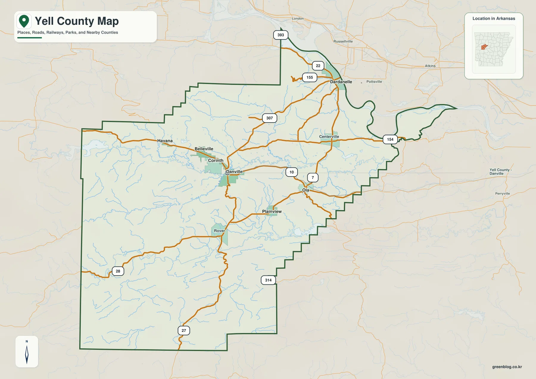
The map therefore has two distinct orientation points rather than one dominant center. Dardanelle is the best place to start when the Arkansas River and northeastern boundary matter. Danville works better for the central interior, the Petit Jean River, and travel toward the southern mountain communities. Keeping those roles separate prevents the county from looking like a single continuous urban corridor.
Most of the smaller cities cluster around the Danville side
The supplied city graphic ranks Dardanelle first at 4,511 and Danville second at 2,289. Ola is shown at 914, Plainview at 550, Belleville at 517, and Havana at 343. These figures are useful for comparing the labels on the map, but they should not be treated as the latest Census estimates. Current population data should be checked with an official statistical source.
The geographic arrangement is more revealing than the ranking alone. Dardanelle stands apart in the northeast. Danville, Belleville, and Havana occupy the central and western interior, while Ola and Plainview extend the settlement pattern east and south. This makes Danville a practical midpoint for several smaller communities even though Dardanelle is the largest city in the graphic.
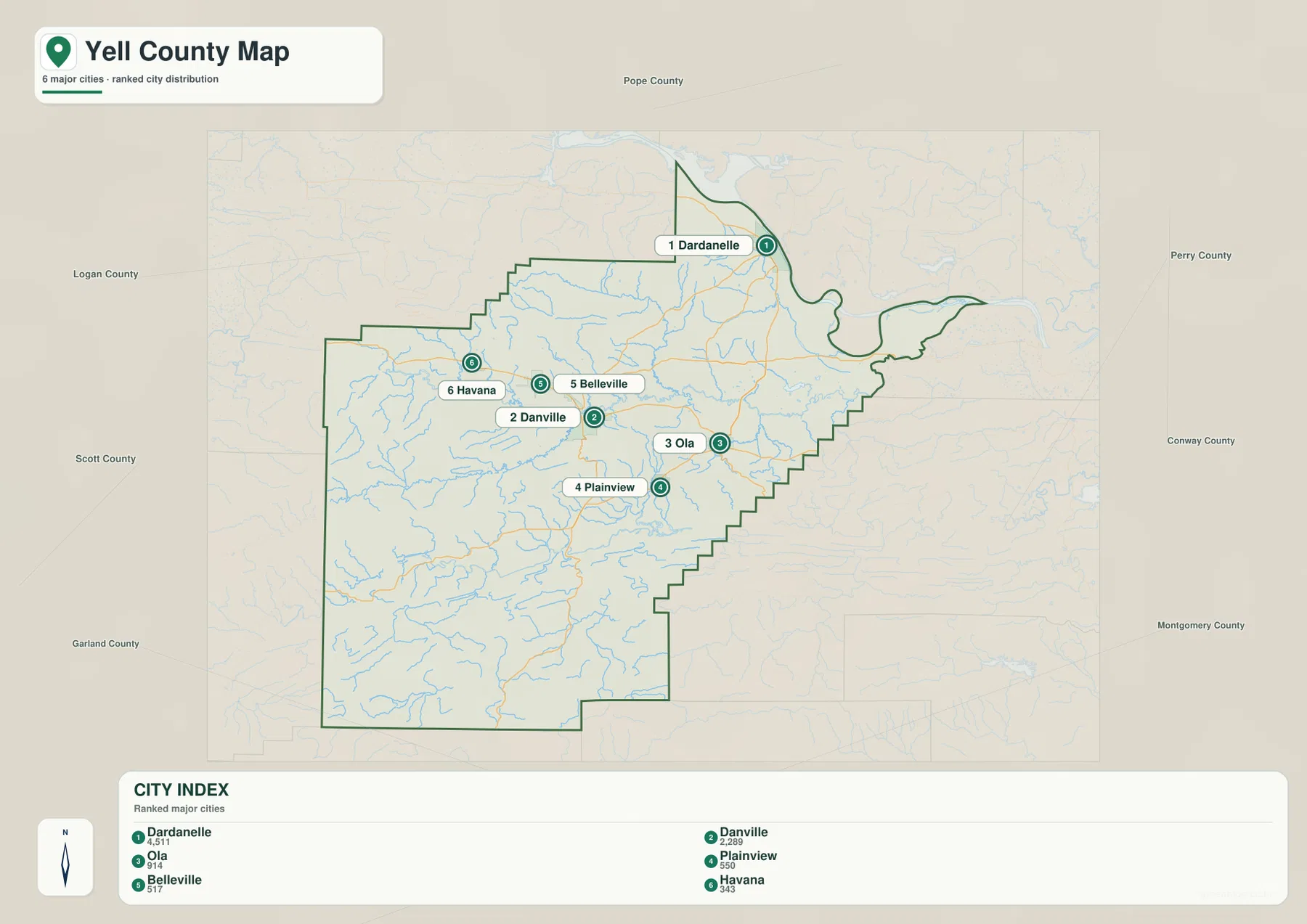
Returning to the reference map after viewing this simplified graphic makes the road pattern easier to follow. Dardanelle connects naturally to the Arkansas River side of the county, while Danville sits within a network of roads serving the interior valley. Plainview marks the transition toward the mountain belt, and Ola helps define the eastern side of the central lowland.
The Petit Jean River opens a broad valley across central Yell County
The Petit Jean River is the strongest water reference for the middle of the county. The Encyclopedia of Arkansas describes it as an east-flowing river that crosses Yell County before reaching the Arkansas River. On the terrain-and-water map, it follows a relatively broad corridor north of Danville, with smaller tributaries descending from higher ground on both sides.
The Little Petit Jean River occupies a separate route farther north. Spring Lake and Cedar-piney Lake provide useful landmarks in the northwestern and north-central area, while Peeler Lake appears closer to the Danville side. The terrain around these features is more open than the narrow valleys visible farther south, which helps distinguish the central river country from the Ouachita ridges.
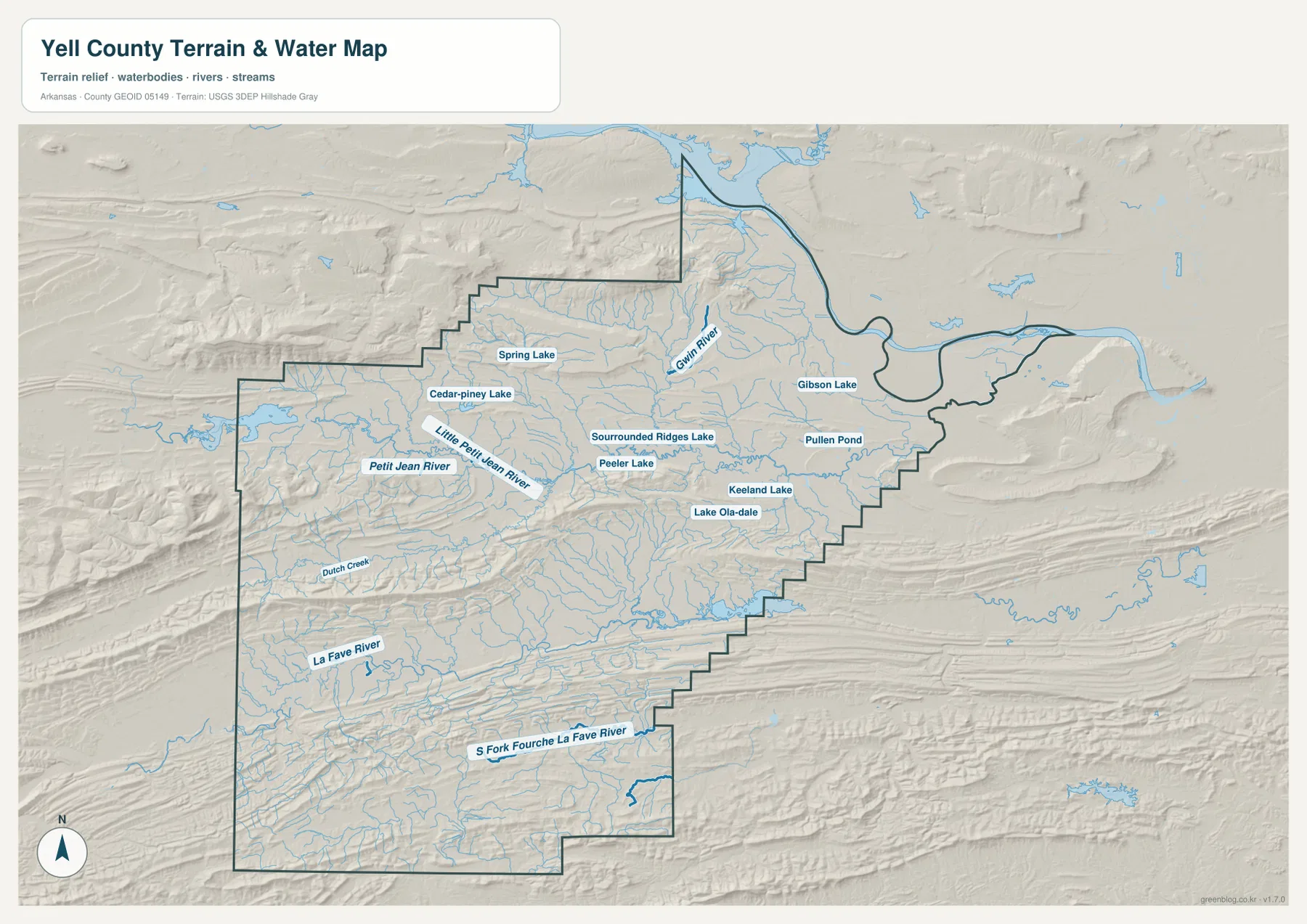
The southern water network looks very different. The La Fave River and South Fork Fourche La Fave River occupy long, narrow valleys between high ridges, and Dutch Creek is one of several smaller streams following the same mountain structure. The Encyclopedia of Arkansas notes that the Fourche La Fave River rises in the Ouachita Mountains and crosses Yell County on its eastward course.
Dardanelle adds a third major water setting because it lies directly on the Arkansas River. The curved county boundary around the northeastern corner follows that river corridor, and Russellville appears across the water. The result is a county where a large river, a broad interior tributary valley, and narrow mountain drainages can all be compared on the same map.
The water image is a county-scale geographic reference rather than a flood-hazard, parcel, navigation, or water-quality map. It is appropriate for locating rivers, lakes, and tributary valleys and for comparing them with roads and towns. Current legal, safety, or property decisions require specialized information from the responsible agencies.
Elevation rises sharply south of the Petit Jean valley
The supplied elevation map gives Yell County an actual range of about 86 to 742 meters, with a mean near 190 meters. The lowest green terrain follows the major river valleys, especially around the Petit Jean and Arkansas river corridors. South and southwest of the central valley, tan and brown ridges become increasingly extensive and form long bands across the county.
Those southern ridges are part of the Ouachita mountain landscape rather than isolated hills. The Fourche La Fave system occupies lower paths between them, which is easy to see when the water and elevation maps are compared. The Encyclopedia of Arkansas also notes that large parts of southern and eastern Yell County are within the Ouachita National Forest, providing context for the broad area of rugged relief.
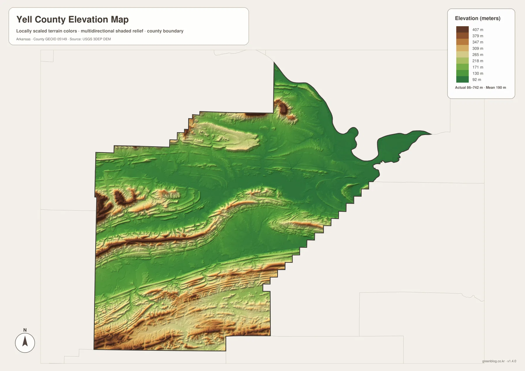
Another high area stands out west of Dardanelle. Mount Nebo State Park is in the Dardanelle area, and Arkansas State Parks documents the mountain setting there. On the elevation map, this high ground rises close to the broad Arkansas River lowland, creating a much more abrupt local contrast than the long parallel ridges across the southern half.
The elevation colors are meant for broad terrain comparison, not survey-grade property measurements. They are useful for seeing where Yell County is higher or lower, but not for construction, drainage design, parcel elevations, or precise slope calculations. Detailed USGS 3D Elevation Program data or professional measurements are better suited to those tasks.
Read the county by moving from river center to river center
A simple way to orient the map is to begin at Dardanelle and identify the Arkansas River first. From there, move southwest into the interior until Danville appears near the Petit Jean River valley. Belleville and Havana fill in the western side of that interior, while Ola and Plainview extend the pattern toward the east and south. This route through the map connects places with the landforms around them instead of reducing the county to a list of town names.
South of Danville, settlement labels become less useful than ridges and waterways. Highways 27 and 28 cross rugged ground where narrow creeks occupy low corridors between long mountain bands. Northeast toward Dardanelle and Centerville, the terrain opens and lowers again near the Arkansas River. Switching between the road, water, and elevation views makes this transition much clearer.
Match the map to the feature you need to explain
The county reference map works best for Dardanelle, Danville, Ola, Plainview, nearby communities, roads, and the boundary. The city view is useful when relative settlement size and position are the main questions. The terrain-and-water image provides the clearest look at the Petit Jean and Fourche La Fave systems, while the elevation map is the strongest choice for the southern mountain belts and lower river valleys.
Using two images together can make a local explanation more specific. Pair the reference and elevation maps around Dardanelle to show how high ground near Mount Nebo rises beside the Arkansas River valley. For Danville, use the reference and water maps to connect the town with the Petit Jean River. In southern Yell County, the water and elevation maps together show streams following narrow routes between long ridges.
Each downloadable JPG measures 3638 × 2572 pixels and is suitable for A3 landscape printing, enlarging place labels, or inserting into reports and classroom handouts. Keep the original aspect ratio when resizing so roads, waterways, and the county boundary are not distorted. Printer margins differ, so a test page is useful before producing multiple copies.
Frequently Asked Questions
Does Yell County really have two county seats?
Yes. Dardanelle and Danville both serve as county seats. Dardanelle is on the Arkansas River at the northeastern edge, while Danville is farther inland near the central Petit Jean River valley.
Which river is the best landmark near Danville?
The Petit Jean River is the clearest river reference near Danville. It runs through the broad valley just north of the city and continues east toward the Arkansas River.
Where is the highest terrain concentrated in Yell County?
The highest terrain is concentrated mainly in the south and southwest, where long Ouachita ridges dominate the elevation map. The supplied range is about 86 to 742 meters, and a separate high area near Mount Nebo also stands out west of Dardanelle.
Map File Information
The ZIP contains the original Yell County reference, city, terrain-and-water, and elevation maps as high-resolution JPG files.
- Included Files: County reference map, city map, terrain-and-water map, elevation map
- Printable Size: 3638 × 2572 pixels each
- File Type: Four high-resolution JPG files in one ZIP archive
Related Maps
Sources and References
- Yell County, Arkansas – Official Website – Official information on Dardanelle and Danville as the county’s two seats.
- Encyclopedia of Arkansas – Yell County – County geography and history, including the Arkansas River Valley and Ouachita National Forest.
- Encyclopedia of Arkansas – Petit Jean River – Background on the river’s route through central Yell County.
- Encyclopedia of Arkansas – Fourche La Fave River – Regional information on the mountain river system crossing southern Yell County.
- Arkansas State Parks – Mount Nebo State Park – Official information about the mountain landscape near Dardanelle.
- USGS 3D Elevation Program – Official elevation and terrain data information.
Green Map creates custom-edited map images using open geographic data sources such as geoBoundaries, Natural Earth, OpenStreetMap, and government open data.
These maps are edited visual materials, not raw data files, and are provided for education, documents, presentations, and graphic reference.