Mississippi County occupies the northeastern edge of Arkansas, with Blytheville and Osceola serving as two county seats and the Mississippi River forming a deeply curved eastern boundary. Download the four high-resolution JPG maps on this page together in one ZIP file. The package includes a general county map, ranked city map, terrain and water map, and elevation map. Big Lake and the Little River system divide much of the western side from the Blytheville area, while the long southern half extends past Osceola, Wilson, and Joiner through extremely low Delta terrain. The supplied elevation map ranges from about 57 to 102 meters, confirming how flat most of the county is.
The county is unusual because it has two courthouse centers rather than one. The Encyclopedia of Arkansas lists Blytheville and Osceola as the county seats, and its Osceola history notes that the dual-seat arrangement dates to 1901. The current county government site still lists separate courthouses in both cities. On the map, Blytheville is the larger northern road center, while Osceola stands much farther south near the Mississippi River side. Using both as reference points makes the long shape of Mississippi County much easier to understand.
Table of Contents
Blytheville and Osceola anchor two different sections of the road map
Blytheville has the densest road pattern on the supplied general map. Routes 239 and 151 pass near the city, with Routes 137 and 150 extending across the northeastern side toward the river country. Dell lies southwest of Blytheville, and a long north–south route continues through Burdette and Luxora toward the middle of the county. Arkansas Northeastern College is also labeled inside the Blytheville area, giving readers an additional landmark for locating the northern urban center.
Osceola forms the second major road reference farther south. Routes 61 and 181 are prominent around the city and connect north toward Luxora and south toward Wilson and Joiner. Route 14 appears near Wilson, while Routes 55 and 118 are labeled around the Joiner side. Etowah lies farther west near Route 140, and Route 158 crosses part of the western interior. Compared with Blytheville, the Osceola and southern road map has longer straight segments separated by broad agricultural fields and drainage lines.
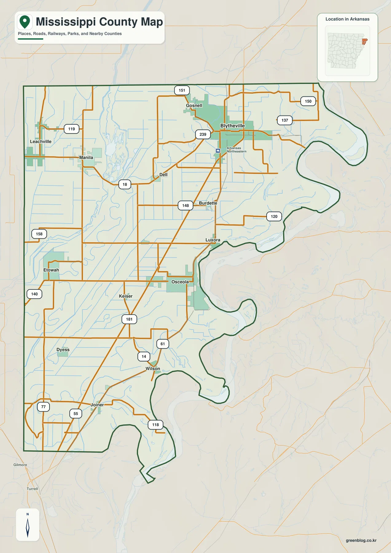
The western towns sit in a different setting. Leachville and Manila are grouped near the northwest, with Routes 119 and 18 among the clearest local references. Etowah, Dyess, and Keiser are spread across the western and southwestern plain. When this road map is compared with the water map, Big Lake, Little River, and numerous ditches become important barriers and corridors between the western communities and the Blytheville side.
The ranked city map shows a northern cluster, a western group, and a long southern extension
The city map ranks six major communities. Blytheville is number 1, Osceola 2, Manila 3, Gosnell 4, Leachville 5, and Wilson 6. These numbers are ranking markers rather than distance labels. Blytheville and Gosnell sit close together in the northeast, Manila and Leachville form a separate western pair, Osceola is much farther south, and Wilson lies below it. The pattern reflects the county’s long shape and the water features that separate several of its settlement areas.
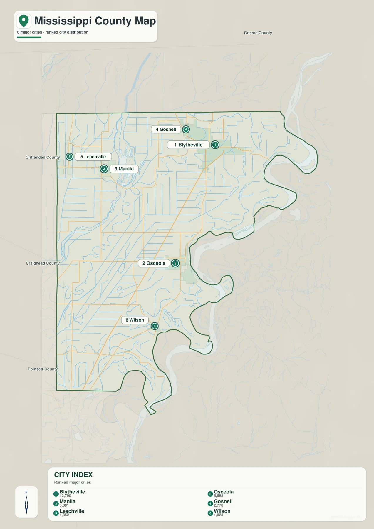
Blytheville and Osceola are both county seats, but they do not form one continuous urban corridor. Blytheville shares the northern section with Gosnell and sits east of the Big Lake–Little River system. Osceola is an independent center farther south along the Mississippi River side. Manila and Leachville are west of the large inland water corridor. The Encyclopedia of Arkansas notes that the western Buffalo Island area was historically separated from the eastern county by Big Lake and Little River, a geographic division that remains easy to recognize on the supplied maps.
The city legend includes numeric values beside the community names, but this article does not reinterpret those figures as current population estimates. The map clearly supports the ranking and locations of the six communities, so those are the facts used here. Current population totals should be checked against recent Census data. The two courthouse locations are also confirmed by the current Mississippi County government website.
Big Lake and Little River separate the western side while the Mississippi River shapes the east
Big Lake and Little River are the strongest water references in the northwestern part of the terrain and water map. Little River enters from the north and connects with the wet lowland around Big Lake, while the Left Hand Chute of Little River winds south from that system. Mallard Lake is labeled close to Big Lake. This water corridor helps explain why the Leachville-Manila side feels geographically separate from Blytheville even though all of the communities are in the northern part of the county.
South of the Big Lake area, the Left Hand Chute continues through broad curves and is joined by a dense pattern of drainage lines. Holthouse Ditch is labeled farther west, and the Tyronza River enters the southwestern side. Pemiscot Bayou Ditch No. 21 runs through the north-central interior. Natural meanders and long straight ditches appear together across the map, reflecting a landscape where water movement and drainage are central to understanding the flat Delta plain.
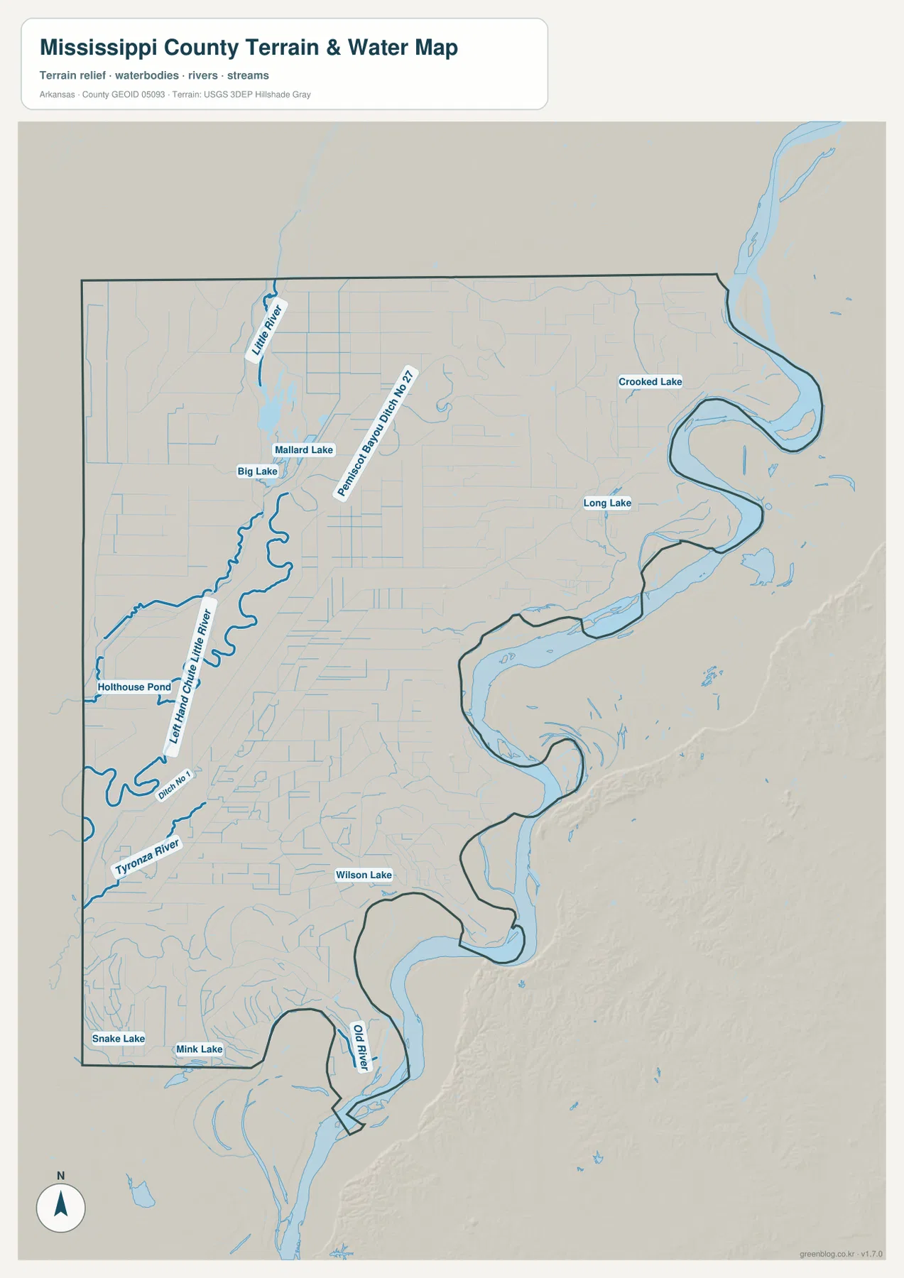
The eastern county edge follows enormous river bends. The Mississippi River name is not repeated across every visible segment of the supplied water image, but the large boundary channel is unmistakable when the terrain and general maps are compared. Crooked Lake and Long Lake lie in the northeastern river lowland. Farther south, Wilson Lake and Old River mark additional curved water features close to the main river corridor. These lakes and old channels make the eastern edge far more complex than the straight western boundary.
Snake Lake and Mink Lake appear near the southwestern boundary, surrounded by many smaller ditches and channels. This water map is intended for general geographic reference. It does not provide current Mississippi River or Little River stage, flood risk, levee condition, agricultural drainage operations, property boundaries, or live road access. Current USGS and local agency information should be used for flood, field, river, or safety decisions.
An elevation range of 57 to 102 meters confirms how flat the county really is
The supplied elevation map shows an actual countywide range of about 57 to 102 meters, with a mean near 72 meters. That is only about 45 meters of total relief across a very large north–south county. Green lowland covers much of the west and south-central interior, while slightly higher tan and brown terrain appears in the northeast and around several eastern river bends. These are subtle differences within a Delta plain, not mountain or hill country.
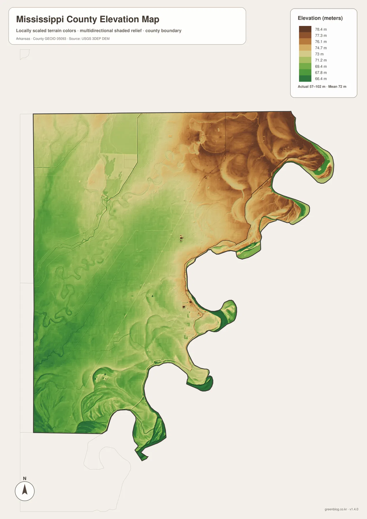
The Big Lake and Little River side is dominated by low green terrain, with small variations following watercourses and former channels. The Left Hand Chute of Little River creates a long winding low corridor, while the surrounding straight ditches cross land with very little visible relief. Manila, Leachville, Dyess, and the southwestern communities occupy this broad low landscape without any major ridge system.
The eastern side has more complicated elevation shading around the Mississippi River bends and old channels. The map alone does not justify labeling a particular feature as a natural levee or engineered levee, so this article does not make that assumption. The important countywide fact is the small 45-meter elevation range. Exact farm, road, levee, or building heights require original USGS elevation data or survey-grade measurement rather than this county-scale image.
Compare Osceola with the Big Lake side to understand the county faster
A practical way to use all four maps is to begin at Blytheville and look south toward Osceola, then west toward Manila and Leachville. The southern direction follows Burdette and Luxora toward Osceola and continues through Wilson and Joiner, with the Mississippi River bends repeatedly appearing along the east. Roads and drainage lines run for long distances through flat agricultural land, making the county’s north–south scale very clear.
The western comparison is different. Manila and Leachville are still in the northern county, but Big Lake, Little River, the Left Hand Chute, and numerous ditches occupy the space between western communities and the Blytheville side. The city map alone makes the locations look close and simple; the water map reveals why the western section has its own distinct geography. Together, the four maps show Mississippi County as more than a flat rectangle: it is a long river-edge county divided internally by lakes, channels, drainage works, and several separate settlement centers.
High-resolution JPG files for both county seats, Big Lake, and river detail
The WebP images in the article are optimized for quick page viewing. The download ZIP contains the same four maps as high-resolution JPG files, each measuring 2572 × 3638 pixels in portrait orientation. Use the general map for Blytheville, Osceola, western towns, and roads; the ranked city map for the six major communities; the terrain and water map for Big Lake, Little River, the Tyronza River, ditches, lakes, and the Mississippi River side; and the elevation map for comparing the subtle 57–102 meter relief.
The JPG files are suitable for classroom reference, presentations, personal printing, and general regional orientation. They should not replace legal boundary records, levee or flood-management maps, parcel surveys, engineering plans, or live navigation. When exact or current information is needed, consult Census TIGER/Line boundaries, USGS hydrography, USGS elevation data, and the responsible county, state, or river-management agency.
Frequently Asked Questions
Why does Mississippi County have two county seats?
Blytheville and Osceola both serve as county seats. Osceola was originally the only county seat, and Blytheville was added in 1901 when the county created the Chickasawba District. The current county government still lists separate courthouse locations in Blytheville and Osceola.
Do the numbers 1 through 6 on the city map show distances?
No. They are ranking markers used on the supplied city map. Blytheville is ranked first, followed by Osceola, Manila, Gosnell, Leachville, and Wilson. Actual road distance and travel time should be checked with a current navigation map.
How flat is Mississippi County?
The supplied elevation map shows an actual range of about 57–102 meters with a mean near 72 meters, so the total difference is only about 45 meters. Most of the county is low Delta plain, with subtle elevation variations around the northeastern and eastern river landscape rather than major hills.
Map File Information
The ZIP contains the general county map, ranked city map, terrain and water map, and elevation map as high-resolution JPG files for printing or offline reference.
- File Type: ZIP containing 4 JPG files
Related Maps
Sources and references
- Encyclopedia of Arkansas – Mississippi County – dual county seats, Big Lake, Little River, drainage history, and county background
- Mississippi County, Arkansas – County Locations – official Blytheville and Osceola courthouse locations
- Encyclopedia of Arkansas – Osceola – Osceola history and the 1901 dual-county-seat arrangement
- U.S. Census Bureau TIGER/Line Shapefiles – county boundary and road data
- USGS National Hydrography – rivers, lakes, ditches, and hydrography data
- USGS 3D Elevation Program – elevation and terrain data
Green Map creates custom-edited map images using open geographic data sources such as geoBoundaries, Natural Earth, OpenStreetMap, and government open data.
These maps are edited visual materials, not raw data files, and are provided for education, documents, presentations, and graphic reference.