Lonoke County in central Arkansas changes steadily from rolling northern terrain around Cabot, Austin, and Ward to broad prairie near Lonoke and Carlisle and then to very low Delta country around England, Coy, Humnoke, and Keo. The water map is filled with long bayous and drainage channels, including Watensaw Bayou, Bayou Two Prairie, and Bayou Meto, while the elevation layer ranges from about 41 to 174 meters. This page brings together the county’s communities, roads, waterways, lakes, and north-to-south terrain change. The same four maps are available as high-resolution JPG files in one downloadable ZIP.
The county’s three-part landscape is useful for understanding almost every map on the page. The Encyclopedia of Arkansas describes the north as gently rolling hills and valleys, the middle as prairie, and the south as alluvial Delta land. That division matches the supplied elevation image closely. Cabot and Austin sit beside the highest ridges in the northwest, while Lonoke and Carlisle occupy much flatter middle ground. England and the southern communities lie in the lowest part of the county. Lonoke, the county seat, sits near the middle of this transition and works well as a reference point.
Table of Contents
Cabot, Austin, and Ward form a compact northern road cluster
The general county map is busiest in the north. Cabot occupies the northwestern urban area, with Austin and Ward close together to the northeast. Route 5 and Route 319 are visible near the northern side, while several major road lines converge through the Cabot-Ward corridor toward neighboring Pulaski County. The three communities are close enough that it makes sense to locate them as one northern cluster before following the map south toward Lonoke.
Road spacing opens up noticeably around the county seat. Routes 40 and 70 provide clear east-west references near Lonoke, while Routes 89 and 294 connect parts of the west and north. Farther east, Route 236 approaches the Carlisle side, and Routes 38 and 321 cross the broad north-central interior. Long straight lines replace much of the tightly packed northern road pattern. This shift fits the move away from rolling terrain into the flatter prairie section described in county reference material.
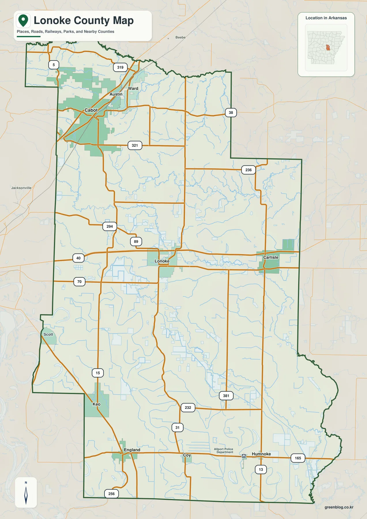
The southern road network spreads across a much larger rural area. Scott and Keo lie toward the west, England is in the southwest, and Coy and Humnoke sit farther east. Route 15 passes through the Keo-England side, Routes 31 and 232 cross the central south, and Routes 13 and 165 serve the Humnoke area. Route 256 appears near the southwestern boundary. Roads here are generally straighter and farther apart, and the map contains many more small channels between them than in the northern urban belt.
The ranked city map separates the northern population center from the prairie towns
The city map ranks six major communities. Cabot is number 1, Ward 2, Lonoke 3, Austin 4, England 5, and Carlisle 6. These numbers are ranking markers rather than distance labels. Cabot, Austin, and Ward are tightly grouped in the north, while Lonoke sits much farther south near the middle of the county. Carlisle is east of Lonoke, and England is separated again in the southern half. The pattern makes clear that Lonoke County has one strong northern cluster plus smaller centers distributed through the prairie and Delta.
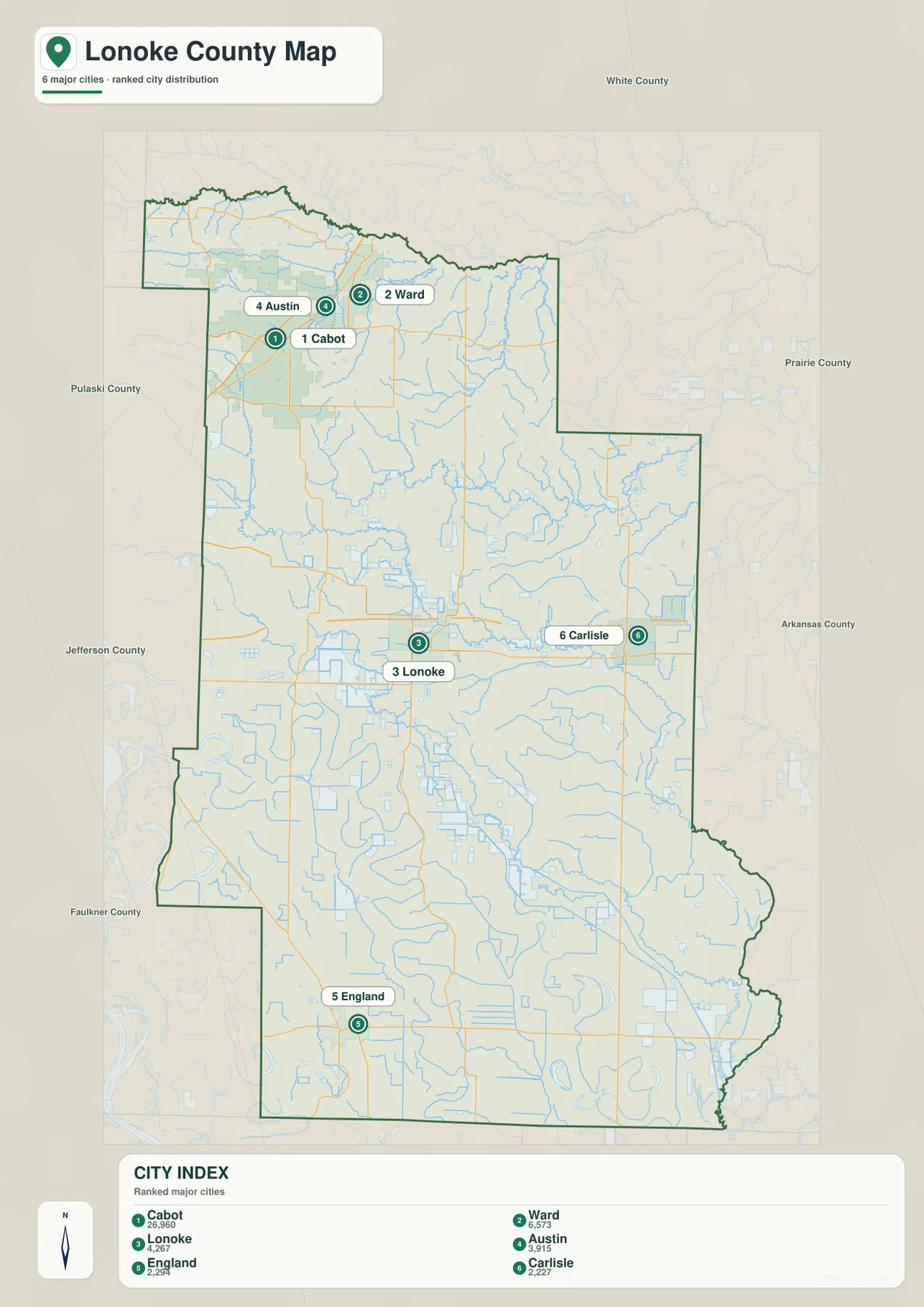
The elevation layer gives useful context to that settlement pattern. Cabot and Austin are next to the county’s highest ground, and Ward sits just east of the main ridges. Lonoke and Carlisle are much lower in the central prairie, while England lies within broad alluvial lowland. The Encyclopedia of Arkansas similarly groups Cabot, Austin, and Ward in the northern hill-and-valley region, Lonoke and Carlisle in the middle prairie, and England and nearby communities in the southern Delta section.
The city legend also contains numeric values beside the names, but this article does not reinterpret those figures as current population estimates. The supplied map clearly supports the ranking and geographic positions of the six communities, so those are the facts used here. Current population totals should be checked against recent Census data. Lonoke’s status as county seat is supported separately by county-specific reference material.
Watensaw Bayou and Bayou Two Prairie cross the broad middle of the county
Watensaw Bayou is one of the clearest named waterways in the north-central part of the terrain and water map. It receives smaller channels descending from the rolling northern ground and continues toward the flatter interior. Swan Lake is labeled close to its middle reach. Pigeon Roost Creek occupies a long northeastern valley, with Burlesons Pond and Youngs Pond farther east, while Fourmile Creek crosses the higher northwestern side. These northern streams are shorter and more confined by relief than the broad lowland waterways farther south.
Bayou Two Prairie is a strong reference across the central county. It winds through the low country between the Lonoke and Carlisle sides and gathers many small channels along the way. On the general map, this same area looks sparsely settled and dominated by long roads. The water map reveals a much denser network beneath that simple road pattern. Because the prairie has little relief, waterways can follow broad, gentle curves rather than narrow mountain valleys.
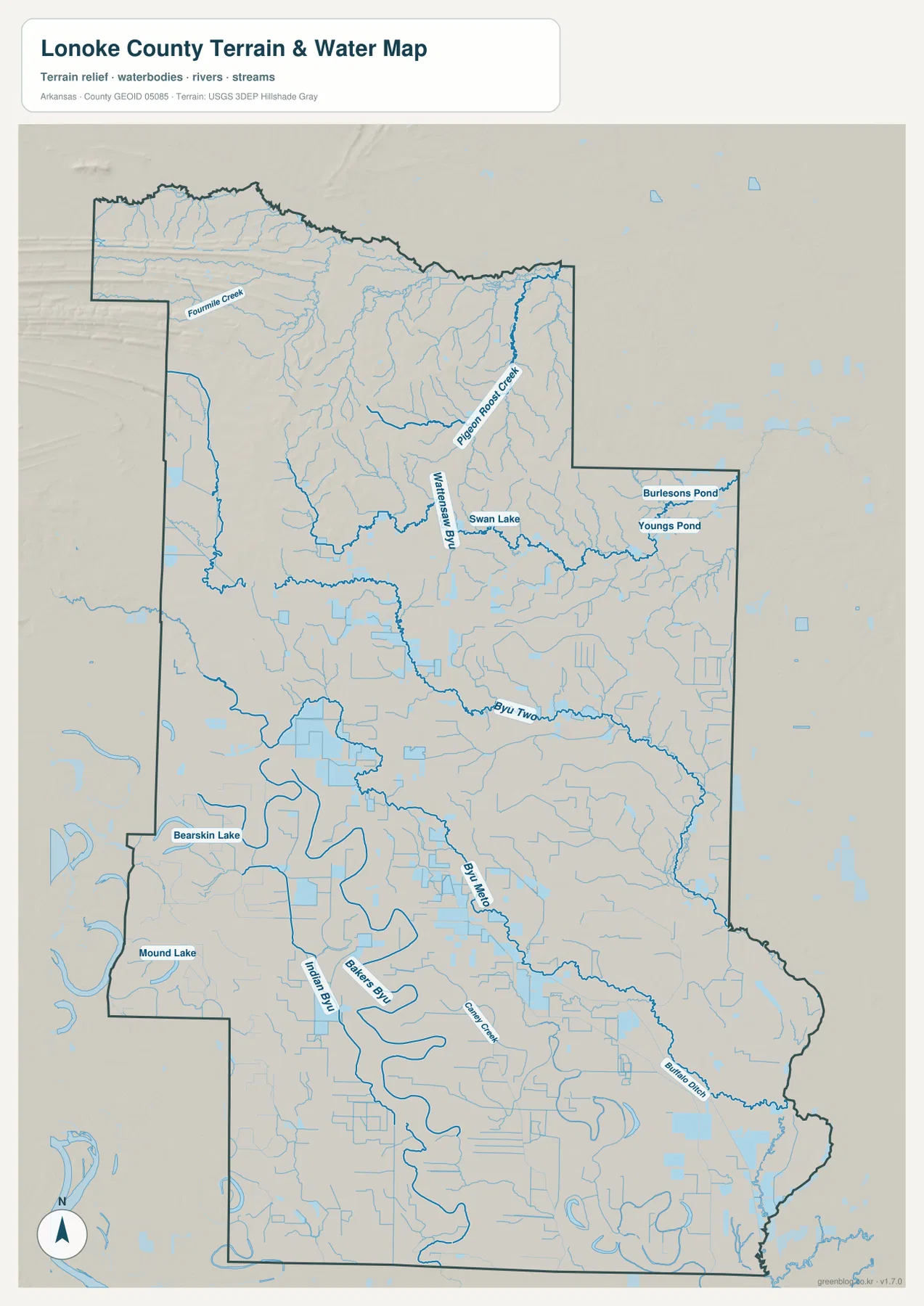
The southern half contains an even more obvious lowland drainage pattern. Bayou Meto, Indian Bay, and Bakers Bay form large bends through the flat southwest and south-central areas, while Bearskin Lake and Mound Lake are labeled nearby. Snake Creek and Buffalo Ditch extend through the southeastern plain. Instead of being cut into deep terrain, many of these waterways spread through broad low ground as meandering channels or straighter drainage lines. The contrast with the north becomes especially clear when the water and elevation maps are compared side by side.
This terrain and water map is intended for general geographic reference. It does not show current water levels, flood risk, agricultural drainage operations, property boundaries, or live road access. Conditions in bayous, creeks, and managed drainage areas can change with rainfall and local water management. For flood, field, or safety decisions, use current information from USGS and the agency responsible for the specific waterway or drainage system.
Elevation falls from 174 meters in the northwest to low Delta ground in the south
The supplied elevation map shows an actual countywide range of about 41 to 174 meters, with a mean near 71 meters. That is roughly 133 meters of relief. The highest brown and tan terrain is concentrated around the northwestern Cabot-Austin side, where long low ridges and short valleys are easy to see. Elevation decreases quickly toward Ward and the central interior, then becomes broadly green across the Lonoke-Carlisle prairie and most of the southern county.
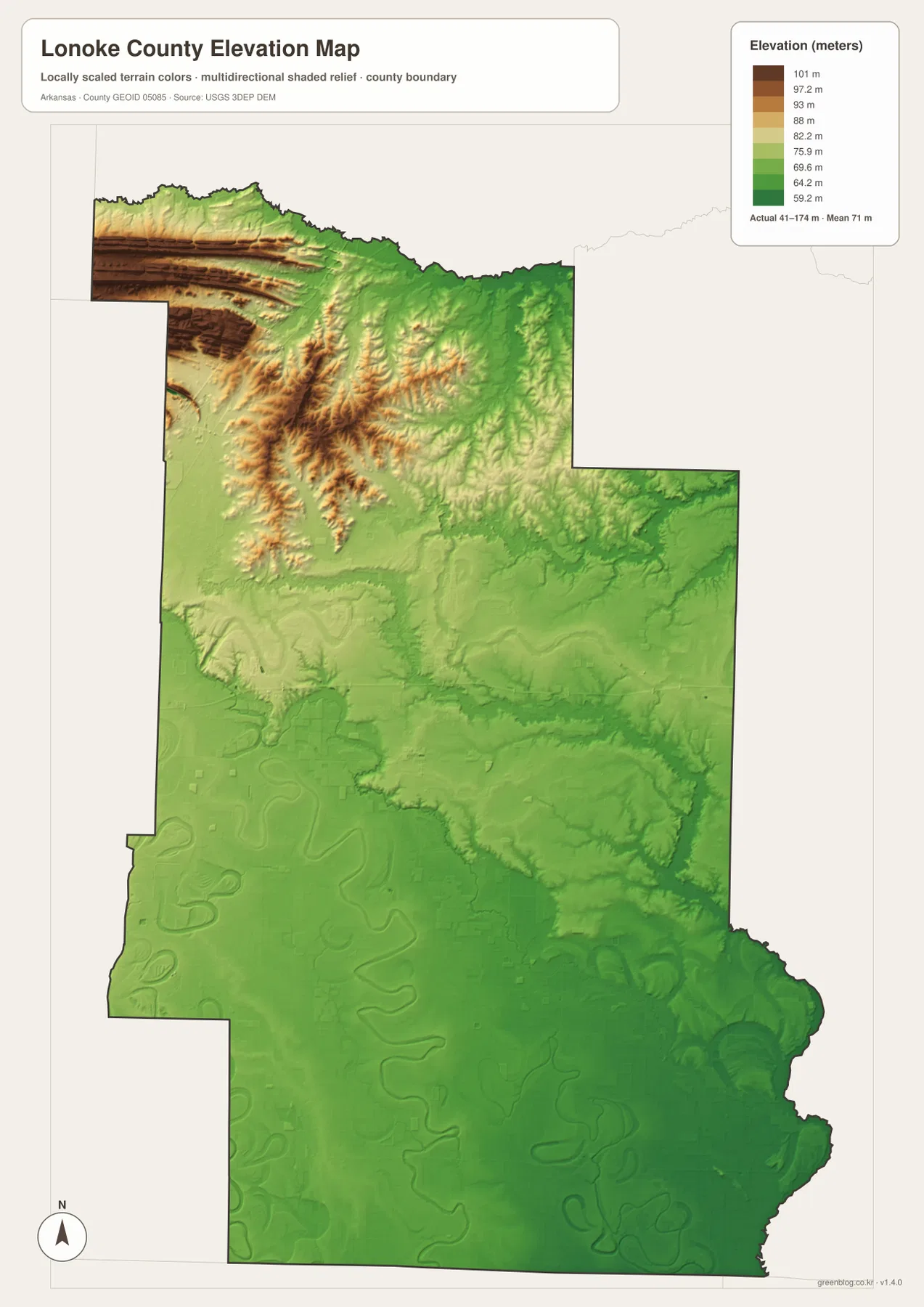
The northern high ground is not a single mountain. Several long ridges run across the northwest and break into shorter hills toward the center. Fourmile Creek and Pigeon Roost Creek occupy lower corridors between them, and the headwaters feeding Watensaw Bayou descend from the same rolling zone. Following the map from Cabot toward Lonoke produces a quick visual change from brown ridge shading to broad green terrain.
South of Lonoke, local relief becomes minimal. England, Coy, Humnoke, Keo, and Scott all sit within much flatter land where river bends, bayous, and drainage channels are more visible than hills. Bearskin Lake and Mound Lake lie within this low western-southern setting. The elevation image is designed for county-scale comparison rather than survey-grade measurement, so exact parcel, road, levee, or building elevations require original elevation data or professional surveying.
Follow the county from Cabot to England to see all three terrain zones
A practical way to use the four maps together is to trace a north-to-south line from Cabot through Lonoke to England. Around Cabot, the road network is dense and the terrain is visibly rolling. Approaching Lonoke, ridges fade and long straight roads cross flatter prairie. Continuing south toward England, elevation changes become very small and lowland waterways such as Bayou Meto, Indian Bay, and Bakers Bay become more prominent. Communities, roads, water, and terrain all change along the same general direction.
The Carlisle side offers another useful comparison. It occupies low central prairie similar to Lonoke, but Bayou Two Prairie and numerous small channels give the water map much more detail than the road map suggests. Heading north from Carlisle leads toward Pigeon Roost Creek and Watensaw Bayou, where the terrain becomes more rolling. Lonoke County is therefore more varied than a simple description of flat agricultural land would suggest: northern hills, central prairie, and southern Delta lowland all appear within one long county boundary.
High-resolution JPG files for cities, roads, bayous, and elevation detail
The WebP images in the article are optimized for quick page viewing. The download ZIP contains the same four maps as high-resolution JPG files, each measuring 2572 × 3638 pixels in portrait orientation. Use the general map for Cabot, Lonoke, Carlisle, southern communities, and major roads; the ranked city map for the six major places; the terrain and water map for Watensaw Bayou, Bayou Two Prairie, Bayou Meto, lakes, and creeks; and the elevation map for the strong north-to-south change in relief.
The JPG files are suitable for classroom reference, presentations, trip preparation, personal printing, and general orientation. They should not replace legal boundary records, parcel surveys, flood studies, drainage-management information, engineering plans, or live navigation. When exact or current information is required, consult Census TIGER/Line boundaries, USGS hydrography, USGS elevation data, and the appropriate local or state source for the specific decision.
Frequently Asked Questions
What is the county seat of Lonoke County?
Lonoke is the county seat. It sits near the middle of the county, where Routes 40 and 70 and several north-south roads provide useful map references. Its central position also makes Lonoke a convenient place for comparing the northern Cabot area with the southern England lowlands.
Do the numbers 1 through 6 on the city map show distances?
No. They are ranking markers used on the supplied city map. Cabot is ranked first, followed by Ward, Lonoke, Austin, England, and Carlisle. Actual driving distance and travel time should be checked with a current road or navigation map.
Where is the highest terrain in Lonoke County?
The highest terrain on the supplied elevation map is concentrated around the northwestern Cabot-Austin side. The actual countywide range is about 41–174 meters with a mean near 71 meters. Terrain becomes much lower across the Lonoke-Carlisle prairie and the southern England-Coy-Humnoke area.
Map File Information
The ZIP contains the general county map, ranked city map, terrain and water map, and elevation map as high-resolution JPG files for printing or offline reference.
- File Type: ZIP containing 4 JPG files
Related Maps
Sources and references
- Encyclopedia of Arkansas – Lonoke County – county seat and the northern hills, central prairie, and southern Delta geography
- U.S. Census Bureau TIGER/Line Shapefiles – county boundary and road data
- USGS National Hydrography – bayous, streams, lakes, and hydrography data
- USGS 3D Elevation Program – elevation and terrain data
Green Map creates custom-edited map images using open geographic data sources such as geoBoundaries, Natural Earth, OpenStreetMap, and government open data.
These maps are edited visual materials, not raw data files, and are provided for education, documents, presentations, and graphic reference.