Lawrence County in northeastern Arkansas sits across one of the state’s clearest terrain transitions. The western side rises into short Ozark Plateau foothills, while the eastern half opens into broad, low Mississippi Delta country. Black River runs through the middle of that change, with Black Rock and Portia close to the river and the larger Walnut Ridge–Hoxie urban area farther east on flatter ground. This page shows communities, roads, rivers, creeks, lakes, and an actual elevation range of about 18 to 236 meters. The same four maps are available as high-resolution JPG files in one downloadable ZIP.
The Encyclopedia of Arkansas describes Black River as a natural divider between the lowlands of the Mississippi Delta and the foothills of the Ozark Plateau within Lawrence County. The elevation map makes that statement easy to visualize: the northwest is covered with brown and tan ridges, while the broad eastern half is almost entirely green. Walnut Ridge, the current county seat, is the best starting point for the road map because the courthouse and several major routes are clustered there. Hoxie lies immediately to the south and forms part of the same east-central settlement center.
Table of Contents
Walnut Ridge and Hoxie organize the eastern road network
The general map shows Walnut Ridge and Hoxie as the largest connected urban area in the county. Route 412 crosses Walnut Ridge from west to east, while Routes 67 and 63 extend south from the Hoxie side. Routes 34 and 231 reach the northeastern plain, and roads such as 228, 349, 230, and 91 cross the lower southeastern area. These routes are generally straighter and more widely spaced than roads in the western hills, reflecting the much flatter terrain east of Black River.
Moving west from Walnut Ridge, the map reaches Portia, Powhatan, and Black Rock near the Black River corridor. Beyond the river, roads begin to bend more often as the land becomes hillier. Lynn, Strawberry, and Smithville are spread across the western interior, while Imboden occupies the northwestern side near the Spring River. Routes 62 and 115 are prominent around Imboden, and Routes 117, 25, and 361 serve the southwestern hills. The difference between the dense eastern road center and the more dispersed western communities is one of the clearest features on the county map.
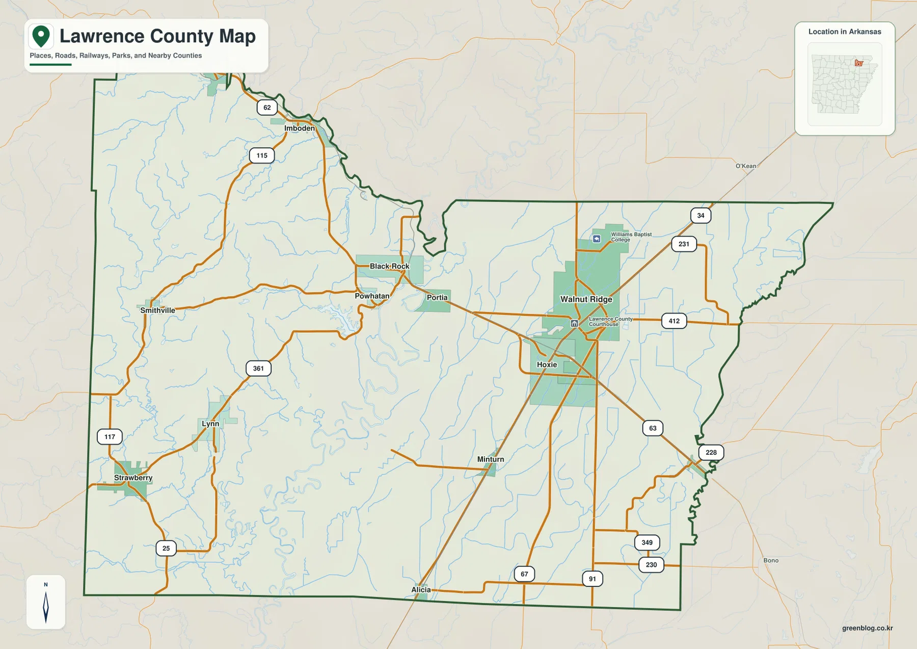
The county outline changes noticeably from west to east. The northwestern boundary bends around the Imboden and Spring River side, and a deep indentation appears near the middle where the Black River corridor narrows the county shape. The eastern half is broader and more rectangular before becoming irregular again in the southeast. Randolph, Greene, Craighead, Jackson, Independence, and Sharp counties are labeled outside the border, placing Lawrence County between the Ozark foothills and the lower northeastern Arkansas plain.
The city ranking splits major communities between the eastern plain and northwest river valley
The city map ranks six major communities. Walnut Ridge is number 1, Hoxie 2, Black Rock 3, Imboden 4, Portia 5, and Ravenden 6. These numbers are ranking markers rather than distance labels. Walnut Ridge and Hoxie form the strongest east-central cluster, Black Rock and Portia sit farther west near Black River, and Imboden and Ravenden are separated from them in the northwest near the Spring River corridor.
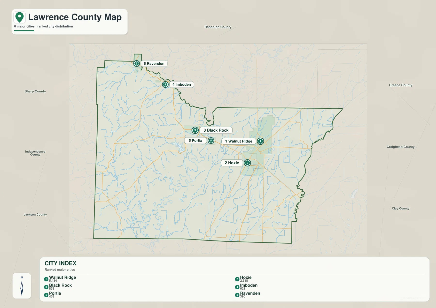
The geography behind that distribution is easier to see when the city map is compared with the road and elevation views. Walnut Ridge and Hoxie occupy low, accessible terrain crossed by several major routes. Black Rock and Portia sit close to Black River, while Imboden and Ravenden are tied to the Spring River side of the county. The Encyclopedia of Arkansas also notes that railroad development shifted the county’s population and economic center eastward toward Walnut Ridge and Hoxie, which fits the modern concentration shown on the supplied map.
The city legend includes numeric values beside the names, but this article does not reinterpret those values as current population estimates. The map clearly supports the ranking and geographic position of the six communities, so those are the facts used here. Anyone needing current population totals should consult a recent Census source. Walnut Ridge’s status as the county seat is supported separately by county-specific reference material.
Black River separates hill-country drainage from the eastern lowland network
Black River is the central water feature on the terrain and water map. It enters from the north, passes near Portia and Black Rock, and continues south through the middle of the county. Its importance is both hydrologic and geographic: the river lies close to the transition between the western Ozark foothills and the eastern Delta lowlands. Comparing the water and elevation maps shows a rapid change from ridged terrain west of the river to broad green lowland on the east.
The Spring River crosses the northwestern corner near Imboden and Ravenden, while Cooper Creek and Strawberry River drain valleys farther west and southwest. Around the Black River corridor, Lake Charles, Portia Bay, Homer Bay, Robinson Bay, Tucker Bay, and Shirey Bay create a dense group of named water features. Rather than one large reservoir dominating the county, the map shows a river landscape with bays, lakes, former channels, and small tributaries close together.
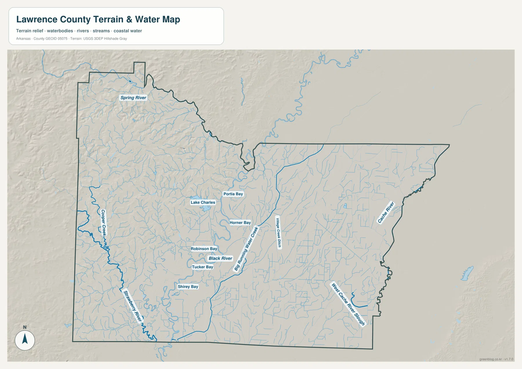
East of Black River, the water network changes character. Village Creek runs through the central-eastern plain, while Cache River follows the eastern side and Cache River Slough appears in the southeast. Streams and drainage channels cross a much flatter surface here than in the west, so many lines are longer and less confined by steep valleys. This contrast between hill-country streams and lowland channels is one of the best reasons to compare the water and elevation maps together.
This terrain and water map is intended for general geographic reference. It does not provide current river stage, flood risk, fishing regulations, property boundaries, or live road access. Conditions on the Black River, Spring River, and Cache River can change with rainfall and upstream conditions. For recreation, flooding, or safety decisions, use current USGS information or guidance from the agency responsible for the specific waterway.
Elevation ranges from 18 to 236 meters across a sharp west-to-east transition
The supplied elevation map shows an actual range of about 18 to 236 meters, with a mean near 94 meters. That is roughly 218 meters of relief within Lawrence County. The northwest is covered by brown and tan ridges, and rolling terrain continues through much of the western half. East of Black River, the map changes abruptly to broad green lowlands with very little local relief. Few Arkansas county maps show such a clear terrain break inside one boundary.
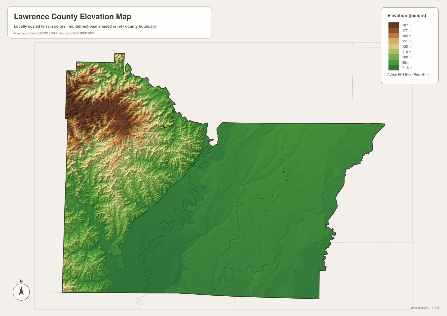
Near Imboden and Smithville, short ridges and narrow valleys repeat across the northwestern corner. The Spring River and smaller tributaries occupy the lower corridors between those ridges. Moving toward Black Rock and Powhatan, the high terrain drops quickly toward the Black River valley. The road map reflects the same change: western roads bend through hills and creek valleys, while long straighter routes become much more common after the terrain opens onto the eastern plain.
Walnut Ridge and Hoxie are firmly within the lower eastern landscape. Beyond them, the Cache River side is even flatter, with only subtle relief visible in the elevation shading. Lawrence County can therefore look like two different regions depending on which side of Black River is being viewed. The elevation image is designed for county-scale comparison rather than survey-grade measurement, so exact parcel, road, bridge, or building heights require original USGS elevation data or a professional survey.
Follow the change from Black Rock to Walnut Ridge for the clearest comparison
A useful way to compare the four maps is to start around Black Rock and move east toward Walnut Ridge. Black Rock sits close to Black River where the western foothills give way to lower country. Passing Portia and continuing toward Walnut Ridge, the elevation colors become steadily greener and the road network becomes straighter and more open. The water map also shifts from Black River bays and nearby hill-country tributaries toward Village Creek and the Cache River lowland.
The northwest provides a second strong comparison. Imboden and Ravenden lie near the Spring River with ridges close on both sides, giving that corner a very different appearance from Walnut Ridge and Hoxie. Strawberry and Lynn in the southwest occupy another rolling area cut by creeks, although the terrain generally lowers toward the central river valley. Looking at these locations across the general, water, and elevation maps shows how Lawrence County connects a river-cut hill region with a broad Delta plain in a relatively short distance.
High-resolution JPG files for Walnut Ridge roads and Black River detail
The WebP images in the article are optimized for quick page viewing. The download ZIP contains the same four maps as high-resolution JPG files, each measuring 3638 × 2572 pixels in landscape orientation. Use the general map for communities and roads, the ranked city map for the six major places, the terrain and water map for Black River, Spring River, Cache River, bays, and lakes, and the elevation map for comparing the western foothills with the eastern lowland.
The JPG files are suitable for classroom reference, presentations, trip preparation, personal printing, and general orientation. They should not replace legal boundary records, parcel surveys, flood studies, engineering plans, or live navigation. When exact or current information is required, consult Census TIGER/Line boundaries, USGS hydrography, USGS elevation data, and the appropriate local or state source for the specific decision.
Frequently Asked Questions
Where are Walnut Ridge and Hoxie on the map?
Walnut Ridge and Hoxie sit close together in the east-central lowland. Walnut Ridge is the current county seat, and Hoxie lies immediately to the south. Several major routes converge around the two cities, making them the easiest reference point for reading the general county map.
Why is Black River important to the geography of Lawrence County?
Black River lies near the transition between the western Ozark foothills and the eastern Mississippi Delta lowlands. The water map shows the river near Black Rock and Portia, while the elevation map changes sharply from brown ridges to green lowland across the same central corridor.
How much elevation change is shown across Lawrence County?
The supplied elevation map shows an actual range of about 18–236 meters with a mean near 94 meters. The highest terrain is concentrated in the northwest and western hills, while Walnut Ridge, Hoxie, and the Cache River side occupy much lower terrain.
Map File Information
The ZIP contains the general county map, ranked city map, terrain and water map, and elevation map as high-resolution JPG files for printing or offline reference.
- File Type: ZIP containing 4 JPG files
Related Maps
Sources and references
- Encyclopedia of Arkansas – Lawrence County – county seat, Black River, Ozark foothills, Mississippi Delta lowlands, and county background
- Encyclopedia of Arkansas – Walnut Ridge – Walnut Ridge and county-seat information
- U.S. Census Bureau TIGER/Line Shapefiles – county boundary and road data
- USGS National Hydrography – rivers, streams, lakes, and hydrography data
- USGS 3D Elevation Program – elevation and terrain data
Green Map creates custom-edited map images using open geographic data sources such as geoBoundaries, Natural Earth, OpenStreetMap, and government open data.
These maps are edited visual materials, not raw data files, and are provided for education, documents, presentations, and graphic reference.