Desha County sits in southeastern Arkansas where the road network of the Delta meets two of the region’s defining rivers. Dumas and McGehee are the easiest urban reference points on the western side of the county, while the county seat, Arkansas City, lies close to the Mississippi River on the southeast. The eastern boundary is far more irregular than the western one because it follows a landscape of large river bends, abandoned channels, lakes, and low floodplain ground. The maps on this page show the county boundary, towns, roads, waterways, and elevation, and the matching high-resolution JPG files are available together in a ZIP download.
This is a county where switching between maps makes a real difference. A road map quickly answers where Dumas, McGehee, Watson, and Arkansas City are, but it does not fully explain the long loops and narrow extensions on the east side. The terrain and water map supplies that missing context by placing the Arkansas and Mississippi rivers beside oxbow-like lakes and smaller channels. The elevation map then shows that the county is low overall, yet still has enough local relief to distinguish river bottoms from slightly higher inland ground. Together, these views make the county’s unusual shape easier to understand without turning the page into a technical GIS report.
Table of Contents
Finding Desha County between the Delta road network and the big rivers
Desha County covers about 741.21 square miles according to the 2020 Census figures summarized by the Encyclopedia of Arkansas. Arkansas City is the county seat, although the larger road hubs on the maps are Dumas and McGehee. The county was created in 1838 from parts of Arkansas and Chicot counties. Today, neighboring counties help orient the map: Arkansas County is to the north, Lincoln and Drew counties are to the west, and Chicot County is to the southwest. The eastern side is shaped by the river corridor rather than by a clean north-south line.
Dumas appears in the western half of the county and has several numbered highways converging nearby. McGehee is farther south, close to the southwest side of the county. Arkansas City is east of McGehee near the Mississippi River, while Watson sits north of the county’s central road network. Tillar lies along the western side between the Dumas and McGehee areas. Places just outside the boundary, including Gould, Gillett, Winchester, and Dermott, provide useful reference points when comparing Desha County with the surrounding Delta.
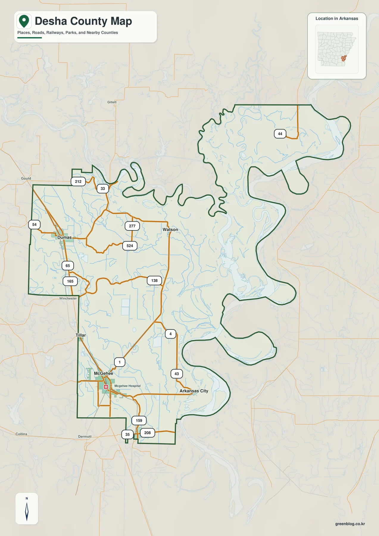
Road numbers make the western side especially easy to follow. U.S. 65 and U.S. 165 pass through the Dumas area, with Arkansas routes 54, 33, and 212 also visible nearby. Around McGehee, Route 1 and Route 4 stand out, while Route 4 continues toward Arkansas City and the river side of the county. Routes 159 and 208 appear near the southern edge, and Route 44 is shown in the northeastern extension. These lines are useful for geographic orientation, but the map is not a turn-by-turn navigation product, so current road closures, bridge conditions, and driving directions should be checked with a live transportation source.
Why the eastern county line looks so different from the western side
The eastern edge of Desha County contains long bulges, narrow necks, and inward curves that can look puzzling on an administrative map. The water map makes the reason much clearer. Large bends of the Arkansas River occupy the central and northeastern river corridor, while the Mississippi River defines the southeastern setting around Arkansas City. Nearby lakes and curved channels echo older river paths. Instead of a rectangular county divided by straight survey lines, this is a landscape where moving rivers and floodplain features have helped shape the boundary visible today.
Arkansas City is especially useful for understanding this relationship. The Encyclopedia of Arkansas identifies it as the county seat and describes its history as a Mississippi River port and steamboat stop. That history fits its location on the map: the town sits much closer to the major river corridor than Dumas or McGehee. Dumas, by contrast, is a western Delta town centered on the road network, while McGehee developed as an important railroad location. Looking at the three cities together shows how Desha County has had more than one kind of transportation center over time.
Six mapped communities show how settlement is concentrated on the inland side
The city map highlights six communities: Dumas, McGehee, Arkansas City, Mitchellville, Watson, and Reed. Their distribution is more informative than a simple ranked list. Dumas and McGehee sit on the western and southwestern side where roads cross broad agricultural ground. Watson is farther north near the middle of the county, and Arkansas City occupies a separate river-side position in the southeast. Mitchellville and Reed are smaller communities, yet their placement helps fill in the long stretch between the larger towns.
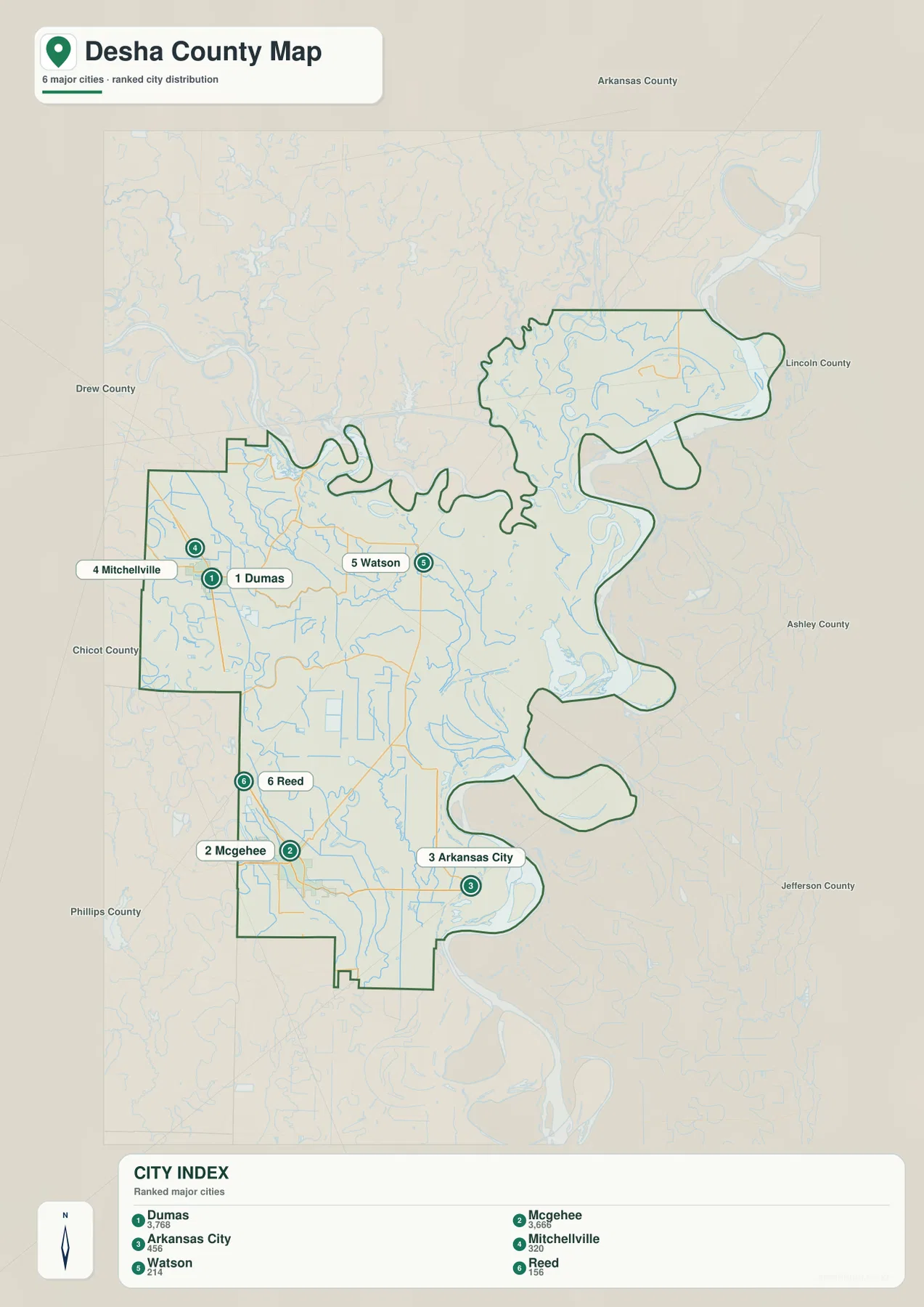
The surrounding county labels also make the map easier to read. Dumas lies toward the side facing Lincoln and Chicot counties, and McGehee is close to the Chicot County direction. Arkansas City is tucked into the southeastern river zone, while Watson is farther inland and north. There are large rural spaces between these places, so distances can feel greater than a quick glance at the county outline suggests. For general orientation, it is often useful to find Dumas or McGehee first and then trace outward to the smaller communities or to Arkansas City.
Following the Arkansas and Mississippi rivers through lakes and old channels
The terrain and water map shifts attention away from towns and toward a dense network of rivers, creeks, lakes, and curved channels. The Arkansas River is labeled along the eastern half of the county, and the Mississippi River is prominent in the southeast. Yancopin Lake and Swan Lake appear in the northeastern section, while Moore Lake and Caillie Lake sit farther south along the river corridor. Near the lower Mississippi side, Pothole Lake is another named feature. The repeated crescents and looping water shapes are among the most distinctive features on the page.
Smaller waterways are easier to see on the inland side. Cypress Creek crosses the broad central-western area, and Big Bayou Macon and Little Bayou Macon are labeled in the southwest. Mud Lake appears near the northwest side. These features create a gradual visual transition: western Desha County is crossed mainly by smaller streams and bayous, while the eastern half becomes increasingly dominated by large river channels, lakes, and floodplain water features. This is why the water map adds so much information that is not obvious from the road map alone.
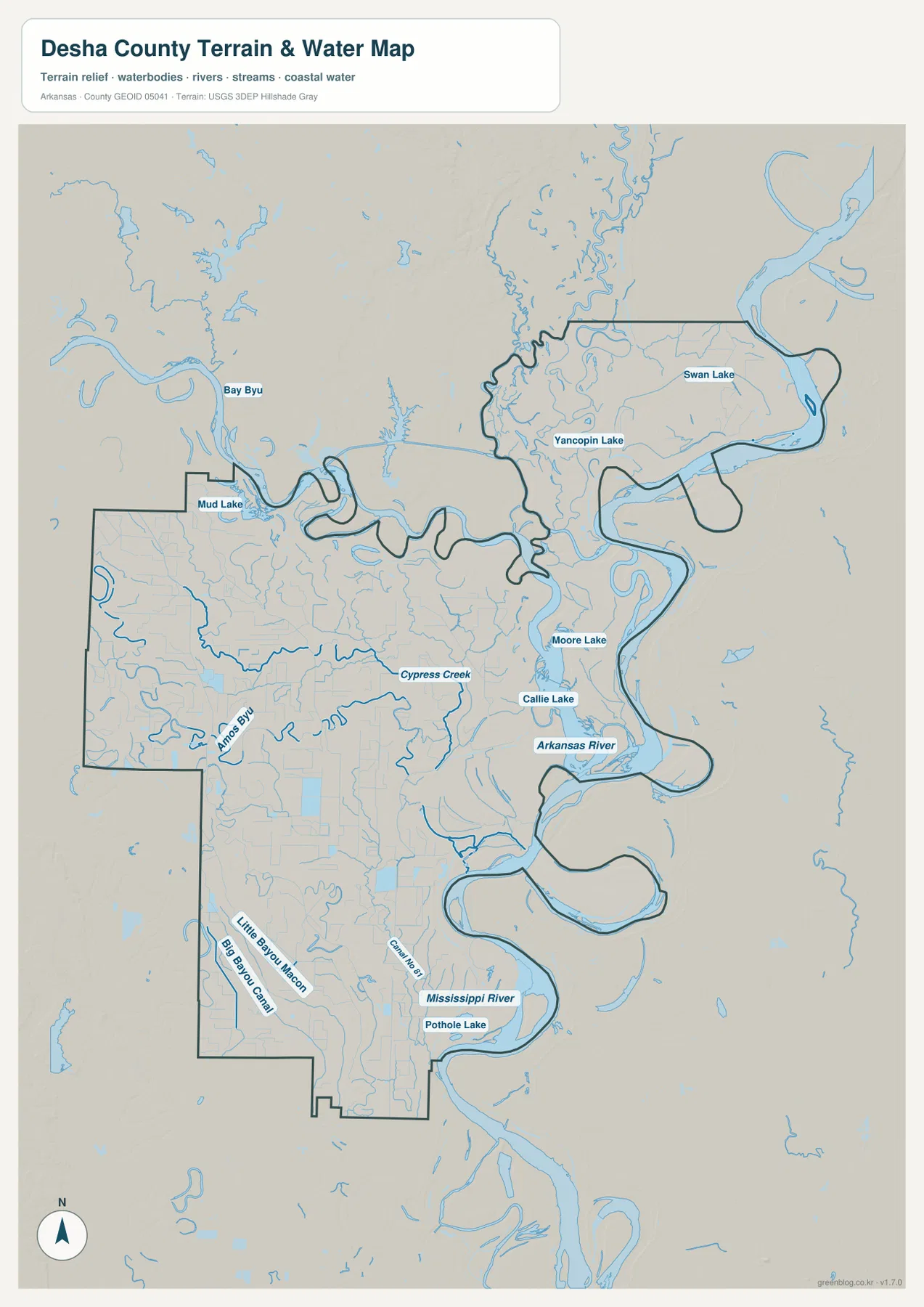
This map should be used as a geographic reference rather than as a flood-risk or navigation chart. Desha County’s river setting makes levees, flood stages, and channel conditions important in real life, but those subjects require current data from the responsible agencies. A blue area on this map does not state whether land is inside a regulated flood zone, and the presence of a channel does not tell you whether it is navigable. For flood insurance, emergency planning, boating, or engineering, consult the latest official mapping and measurements.
A low county with meaningful relief inside a 34–62 meter range
Desha County is very low compared with many parts of Arkansas. The elevation map reports an actual range of about 34 to 62 meters and a mean near 44 meters. Even within that narrow span, the pattern is not uniform. Green bands follow many river-side low areas, especially along the Arkansas and Mississippi river corridors. Warmer tan and brown tones appear more often on slightly higher ground toward parts of the west and north, as well as in portions of the northeastern extension.
In a Delta landscape, a difference of only a few meters can still be useful when studying drainage and river forms. The large loops visible on the water map often correspond with lower green corridors on the elevation map. Inland from the major rivers, the color changes are gentler and broader. Around Dumas and McGehee there is no mountain ridge to identify, but there are subtle transitions between slightly higher agricultural ground, shallow drainage paths, and low river-related terrain. Viewing the water and elevation maps together is the easiest way to see those relationships.
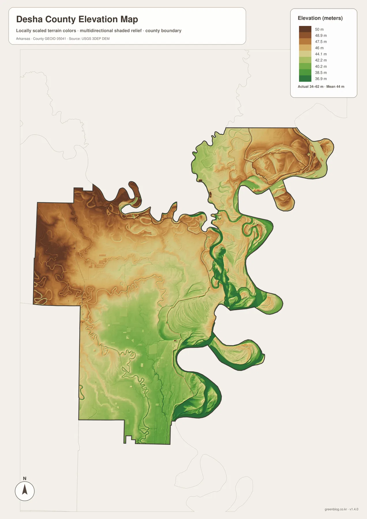
The shaded elevation image is designed for county-wide comparison, not for surveying a property or planning drainage construction. It is based on USGS elevation data and simplifies a large number of measurements into a readable surface. If an exact ground height is needed for a building site, levee, road project, or engineering decision, use the original elevation dataset or a professional survey. For classroom work, travel planning, regional description, or a quick understanding of the Delta terrain, the county-wide map is much more convenient.
River ports, railroads, and highways explain the county’s multiple centers
Desha County does not have one town that explains every part of its geography. Arkansas City reflects the county’s river history, Dumas stands out in the western road network, and McGehee reflects the importance of inland rail transportation. The Encyclopedia of Arkansas notes that steamboats once made Arkansas City a regular port of call, while later rail development helped towns in the county interior grow. Dumas and McGehee were incorporated in the early twentieth century, and both became important local centers even though the county seat remained at Arkansas City.
That history is useful because the modern map might otherwise seem counterintuitive. The county seat is not the place with the densest collection of highway lines, and the largest towns are not on the biggest river bend. Dumas is well placed for north-south road travel, McGehee anchors the southwestern part of the county, and Arkansas City remains the administrative center near the Mississippi. These different roles help explain why a visitor may need more than one reference point when locating farms, communities, public offices, or river features.
Choosing the right Desha County map for your task
For a first look at the county, start with the main map because it combines town names, major roads, streams, and the boundary. The city map is better when the goal is simply to compare the placement of Dumas, McGehee, Arkansas City, Watson, Mitchellville, and Reed without extra road labels. Anyone researching river geography should move to the terrain and water map, where the Arkansas River, Mississippi River, lakes, creeks, and bayous are much easier to identify.
The elevation view is most useful after the river system is familiar. Find the low green corridor along a major channel, then compare the same place on the water map to see how floodplain forms and river bends line up. If your project only needs a printable county outline with towns and roads, the main map may be enough. Separating these purposes keeps each image readable rather than crowding every label and terrain layer onto one page.
The WebP images in the article are sized for fast viewing online. The downloadable JPG versions are 2572 by 3638 pixels each and use a portrait A3 proportion, giving you more room for printing, presentations, school materials, or a local reference binder. These files are general-purpose geographic maps. Legal boundary interpretation, property ownership, flood determinations, current driving conditions, and engineering decisions should always be checked against the latest authoritative datasets.
Frequently Asked Questions
Is Arkansas City really the county seat even though Dumas and McGehee are larger map reference points?
Yes. Arkansas City is the county seat of Desha County. Dumas and McGehee may stand out more strongly on the road map because they are larger inland population and transportation centers, but county-seat status is an administrative role rather than a ranking by population or highway traffic. Arkansas City’s location beside the Mississippi River also reflects the county’s earlier river-transport era.
Why does Desha County have so many loops and narrow extensions on its eastern boundary?
The terrain and water map shows that much of the eastern boundary lies within a landscape shaped by major river bends and old channels associated with the Arkansas and Mississippi rivers. Lakes and crescent-shaped water features remain around the modern channels, so the county outline is much more irregular than the straighter inland boundaries. For a legal boundary determination, use the official Census or state boundary data rather than the illustrated map.
What does the elevation map add in such a flat Delta county?
The county is low overall, but the map still shows a range of roughly 34 to 62 meters. Low green areas follow many river and channel corridors, while somewhat higher ground appears inland. Those small differences help explain why water features occupy particular paths across the floodplain. The map is appropriate for regional comparison, not for property surveying or engineering-grade elevation measurements.
Related Maps
Sources and references
- Encyclopedia of Arkansas – Desha County – county seat, area, formation, river setting, and transportation history
- Encyclopedia of Arkansas – Dumas – background on Dumas and its Delta transportation setting
- Encyclopedia of Arkansas – McGehee – location and railroad-related development of McGehee
- U.S. Census Bureau TIGER/Line Shapefiles – source data for county boundaries and major transportation features
- USGS National Hydrography – rivers, streams, lakes, and other hydrographic data
- USGS 3D Elevation Program – elevation and terrain data
Green Map creates custom-edited map images using open geographic data sources such as geoBoundaries, Natural Earth, OpenStreetMap, and government open data.
These maps are edited visual materials, not raw data files, and are provided for education, documents, presentations, and graphic reference.