Arkansas County occupies a broad lowland landscape in southeastern Arkansas, with Stuttgart in the northwest and DeWitt near the middle of the county. The White River follows much of the eastern edge, while a winding reach of the Arkansas River touches the south. The maps on this page show the county boundary and roads, the distribution of six labeled communities, waterways and terrain, and relative elevation. High-resolution JPG versions of all four supplied maps are available together in the download file.
This is not a county where mountain ranges dominate the view. The Association of Arkansas Counties describes the landscape as rich, flat delta farmland, and that character is easy to recognize when the water and elevation maps are compared. Numerous bayous, ditches, small channels, bays, and river bends cross or border the county. The relatively modest elevation range makes those waterways especially useful for understanding why the eastern and southern edges look so different from the straighter road network across the interior.
Table of Contents
A lowland county framed by the White and Arkansas rivers
The county outline becomes much easier to understand once the two large rivers are used as reference points. The White River forms the long, irregular eastern boundary. Instead of a straight administrative line, the edge repeatedly curves around river bends and lowland water features. At the south, the Arkansas River creates another strongly sinuous boundary. The supplied terrain-and-water map also shows many smaller named features between those two rivers, so the county is better understood as a network of lowland waterways than as a simple rectangle on a state map.
On the western side, King Bayou Ditch, Salt Bayou Ditch, Bayou Meto, and Hampton’s Reservoir appear close to one another. Mill Bayou lies farther toward the interior. Little LaGrue Bayou and LaGrue Bayou run through the eastern half, while Maddox Bay, Stinking Bay, Indian Bay, and Moon Bay are labeled near the White River side. Farther south, Bay Bayou and Merrisach Lake sit near the Arkansas River. These names are useful landmarks when matching the water map to the county outline, particularly in places where roads alone provide little sense of the natural landscape.
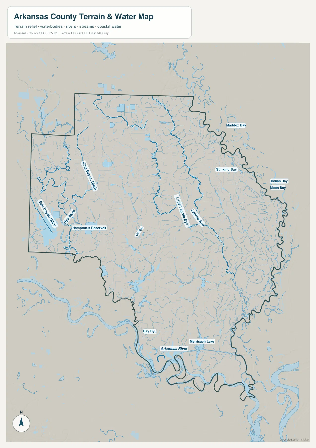
The water map should be treated as a general geographic reference, not as a flood-risk, navigation, drainage-engineering, or parcel map. It can show where major and minor water features lie in relation to the county boundary, but it does not provide current flood zones, levee conditions, channel depths, or legal water boundaries. For those decisions, original USGS data and the appropriate federal, state, or local source are the safer choice.
Stuttgart, DeWitt, and the road network across the interior
The county-and-road map places Stuttgart in the northwest and DeWitt closer to the center. Around Stuttgart, U.S. 63 is one of the clearest route labels. Inside the county, Arkansas highways including 146, 130, 33, 1, 17, 44, 152, and 153 connect different parts of the lowland interior. U.S. 165 becomes especially prominent in the south near Gillett and continues toward the Arkansas River. Rather than one dominant expressway dividing the county, the map shows a web of state and U.S. routes serving communities separated by large rural areas.
DeWitt is positioned near the meeting of Arkansas 1 and Arkansas 130. Almyra lies to the north between the two larger centers, while St. Charles is farther east near the White River side. Gillett is south of DeWitt along the U.S. 165 corridor. These relationships make the map useful for orientation even when a visitor does not need turn-by-turn directions. It shows which town is a practical reference point for the northern, central, eastern, or southern part of the county and provides a stable base for comparing the water and elevation maps.
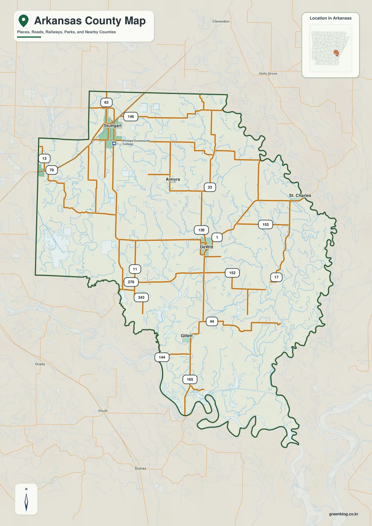
Arkansas County has two county seats, DeWitt and Stuttgart. That detail matters because someone searching for a single administrative center may otherwise assume one city must be the sole seat. The two centers are also visually useful on the map: Stuttgart anchors the northwest, while DeWitt provides a central reference for roads leading toward St. Charles, Gillett, and the interior bayous.
Six labeled communities spread across a wide rural county
The city-index map identifies Stuttgart, DeWitt, Gillett, St. Charles, Humphrey, and Almyra. The values printed on the supplied graphic are 7,903 for Stuttgart, 2,933 for DeWitt, 378 for Gillett, 250 for St. Charles, 220 for Humphrey, and 146 for Almyra. These should be read as the reference values built into this map rather than as live population estimates. Their main purpose here is to show the relative ranking and geographic spread of the labeled communities.
The pattern is notable because the six places do not form one compact urban cluster. Stuttgart is clearly separated in the northwest, DeWitt is near the center, and Almyra lies between those larger places but farther east. St. Charles sits near the White River boundary. Gillett is well to the south, and Humphrey appears on the western side. The resulting layout fits the broader character of a large agricultural county in which small communities are separated by fields, waterways, and long stretches of local roads.
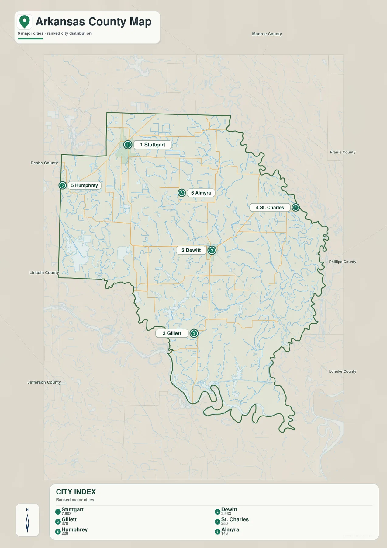
Gillett is also a helpful reference for locating Arkansas Post National Memorial. The National Park Service places the park entrance about seven miles south of Gillett via U.S. 165 and Arkansas Highway 169. The memorial itself is not a labeled point on the supplied city-index map, so it should not be confused with one of the six city markers, but the official directions explain why Gillett and the southern road corridor are useful geographic anchors for that part of the county.
Elevation changes are small, but the river lowlands stand out
The elevation map gives an actual countywide range of about 37 to 75 meters and a mean of roughly 55 meters. That is a modest difference compared with mountainous parts of Arkansas, yet the local color scale reveals a clear contrast inside the county. Much of the north and northwest appears in tan and brown shades that represent relatively higher ground, while greener lower areas become more extensive along the eastern side and near the Arkansas River in the south.
Narrower green corridors also extend inward from the lower eastern side. When those shapes are compared with the water map, several line up with the general position of bayous and tributary channels. The point is not that every color change marks a named stream, but that lower terrain and the drainage network are closely related in the broad visual pattern. Around the southern river bends, low colors widen again, reinforcing the difference between the river margin and the somewhat higher interior and northwestern ground.
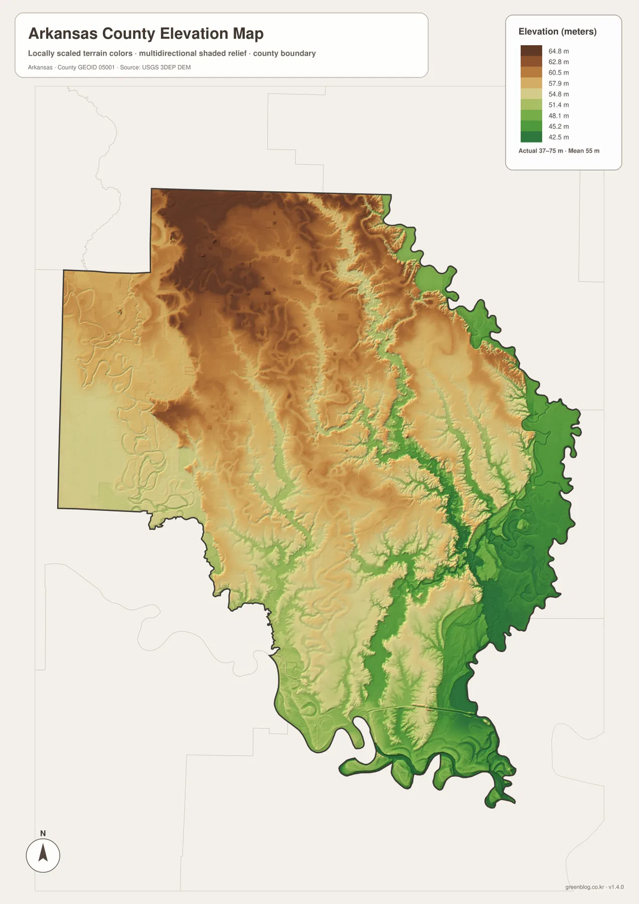
This shaded elevation surface is intended for county-scale comparison. It is not precise enough to determine the elevation of an individual farm field, building site, road grade, or drainage project. For engineering, construction, or detailed land analysis, use the underlying USGS 3D Elevation Program data or professional survey information. For ordinary map reading, however, it clearly shows why the White River and Arkansas River margins appear as lower parts of an otherwise broadly flat county.
What the four maps reveal when they are compared
Each image answers a different practical question, but the strongest understanding comes from matching the same places across them. Start with Stuttgart and DeWitt on the county map to establish orientation. Then use the city-index map to add Gillett, St. Charles, Humphrey, and Almyra. Once those places are familiar, the water map shows how close St. Charles is to the eastern river boundary and how the southern part of the county is shaped by the Arkansas River and its nearby waters.
The elevation map adds one more layer without turning the page into a technical terrain study. It shows that the low river margins are not simply decorative bends in the boundary; they correspond to the lower part of the county’s relief. Meanwhile, the northwest around Stuttgart is generally higher within the county’s limited range. This kind of comparison is useful in classroom work, local-history material, presentations, or reports where a single road map would not fully explain the setting.
Arkansas County is also historically distinctive. The Association of Arkansas Counties identifies it as the oldest county in Arkansas, and reference sources list its establishment in 1813. Arkansas Post, in the southern part of the county near Gillett, adds another strong river-related historical landmark. Those facts are not required to read the maps, but they help explain why the two large rivers and the southern road corridor are meaningful parts of the county’s geographic story.
Choosing the right map for print, reports, or reference
Use the county overview when you need a broad picture of roads, communities, waterways, and the boundary on one page. The city-index version is better when the location and relative ranking of the six labeled communities should be visually simple. Choose the terrain-and-water map when rivers, bayous, reservoirs, lakes, and drainage features are the main subject. The elevation map works best when you want to show the difference between the slightly higher interior and northwest and the lower White and Arkansas River margins.
The WebP images displayed in the article are reduced for convenient web viewing. The download archive contains the original high-resolution JPG versions at 2572 × 3638 pixels each. Those larger files are a better choice for printing or for placing the maps at a larger size in a report or presentation, because road shields, place labels, and waterway names remain easier to read than they would in a screen capture.
Frequently Asked Questions
Does Arkansas County have one county seat or two?
It has two county seats: DeWitt and Stuttgart. On the supplied maps, Stuttgart provides a strong reference point in the northwest, while DeWitt is closer to the middle of the county and connects to several state routes leading toward the east and south.
Which map is best for understanding the White River and Arkansas River sides of the county?
Use the terrain-and-water map first because it shows the large river boundaries together with bayous, bays, lakes, reservoirs, and smaller channels. Then compare it with the elevation map, where the eastern and southern river margins appear among the lower parts of the county.
Can the 37–75 meter elevation range be used for a specific property or construction site?
No. The range is appropriate for broad county-scale comparison, not site-specific measurement. Parcel work, drainage design, construction, or other precision uses should rely on original elevation data and, when necessary, professional surveying.
Map File Information
The ZIP contains the high-resolution JPG versions of the Arkansas County overview, city-index, terrain-and-water, and elevation maps.
- Included Files: county map, city map, water map, elevation map
- Printable Size: 2572 × 3638 px each
- File Type: JPG
Related Maps
Sources and References
The geographic descriptions above are based primarily on the supplied Arkansas County maps. The following official and trusted sources provide county background and documentation for boundaries, waterways, elevation, and the Arkansas Post area.
- Association of Arkansas Counties – Arkansas County – dual county seats, delta farmland, and river-boundary background
- Encyclopedia of Arkansas – Arkansas County – county history and community background
- U.S. National Park Service – Arkansas Post National Memorial – official information for the Arkansas Post area near Gillett
- U.S. Census Bureau TIGER/Line Shapefiles – county-boundary and geographic reference data
- USGS National Hydrography – national water-feature reference
- USGS 3D Elevation Program – elevation-data reference
Green Map images are edited visual materials based on open geographic data. They are suitable for education, documents, presentations, printing, and general geographic reference, but they do not replace official legal boundaries, flood maps, navigation products, engineering datasets, or professional surveys.
Green Map creates custom-edited map images using open geographic data sources such as geoBoundaries, Natural Earth, OpenStreetMap, and government open data.
These maps are edited visual materials, not raw data files, and are provided for education, documents, presentations, and graphic reference.