Ziebach County occupies a broad part of north-central South Dakota, extending from the country around the Moreau River to a long southern edge shaped by the Cheyenne River. Its outline is easy to recognize because the large northern section steps inward before continuing into a southeastern extension. This page uses a Ziebach County map together with separate place, water, and elevation views to show where Dupree and Eagle Butte sit, how the numbered roads cross the county, and how the river valleys divide the higher ground. You can download high-resolution JPG versions of all four supplied maps in one ZIP for printing or closer inspection.
Dupree is the most useful starting point for orientation. Road 212 crosses the central part of the county near Dupree, while Road 65 provides a north-south reference through the same area. From there, the map can be read outward toward the Moreau River in the northern half and the Cheyenne River along the southern boundary. The city view strips away much of the road detail so Eagle Butte and Dupree are easier to compare, and the water and elevation maps explain why so many small drainage lines cut across the county between the two major rivers.
Table of Contents
Road 212 and Dupree provide a practical center point
On the general county map, the Ziebach County Courthouse label appears close to the main central road junction. The same area corresponds closely with Dupree on the city map. Road 212 runs west to east through this part of the county, and Road 65 crosses it in a north-south direction. Those two routes make a simple frame for reading the rest of the page: Road 20 is farther north, while the road network becomes more varied toward the southern half and the Cheyenne River side.
Several other numbered roads help distinguish the lower part of the county. Road 63 is visible in the southeastern extension, Roads 13, 5, 6, 8, and 12 are labeled across southern areas, and Roads 73 and 34 appear near the western and southwestern edges. These labels should not be treated as a complete transportation hierarchy, but they are useful for seeing how movement through the county is organized at a broad scale. In many places the roads pass through terrain cut by streams, so the pattern becomes less simple than the longer segments across the north.
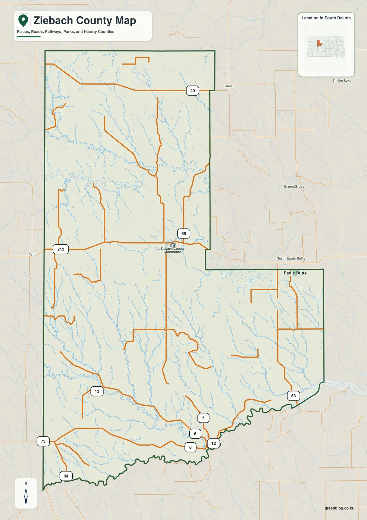
Labels outside the county line add regional context. Faith appears to the west, Isabel and Green Grass are shown to the east, and Eagle Butte is prominent near the southeastern portion of the outline. A small South Dakota inset in the upper-right corner places Ziebach County within the state as a whole. The map works well for county-scale orientation, but it is not intended for parcel research, exact address searches, or legal boundary decisions.
The city view makes the separation between Dupree and Eagle Butte clear
The supplied city map emphasizes two ranked places: Eagle Butte and Dupree. The printed index values are 1,458 for Eagle Butte and 557 for Dupree. They are best treated as the values used for this particular map rather than as a promise of the latest population estimate. The positions are more useful for geographic orientation. Dupree appears in the central portion of the county near the Road 212 corridor, while Eagle Butte is far to the southeast in the extended section of the boundary.
There is a large amount of open map space, stream detail, and relief between the two markers. That makes the settlement pattern look very different from a compact urban county where several major places sit close together. Names around the edge, including Corson County, Dewey County, and Pennington County, help place the map within the surrounding part of South Dakota without overwhelming the main view. The city map does not provide driving distance or travel time, so current road and navigation information should be used for an actual trip.
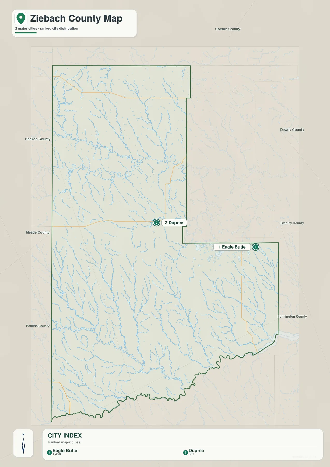
For a presentation or school project, this simplified version is useful when the main question is where the two prominent mapped places are located. Dupree serves as a central reference, and Eagle Butte stands out in the southeastern extension. When the task is to explain how those places connect to the wider road system, it makes sense to place the city map beside the general map instead of asking one image to carry every label.
Small creeks fill the land between the Moreau and Cheyenne rivers
The terrain-and-water map brings the drainage network forward. Moreau River winds across the northern half of the county, while Cheyenne River follows much of the southern boundary. Between them, numerous smaller channels descend through the uplands and form a dense pattern of valleys. Thunder Butte Creek is labeled in the northwest and joins the Moreau system, while Bear Creek appears farther east in the northern half. These features immediately show that the county is more deeply cut by drainage than a simple outline map might suggest.
The central and southern areas contain many more named streams. Rattlesnake Creek, Cottonwood Creek, Little Cottonwood Creek, Ash Creek, Dupree Creek, and Ruby Creek are among the labels visible on the supplied map. Rattlesnake Lake appears in the southwest, and Sears Dam is marked in the south-central area. Many thinner tributary lines remain unnamed at this scale, but together they show how frequently watercourses descend toward the larger river corridors.
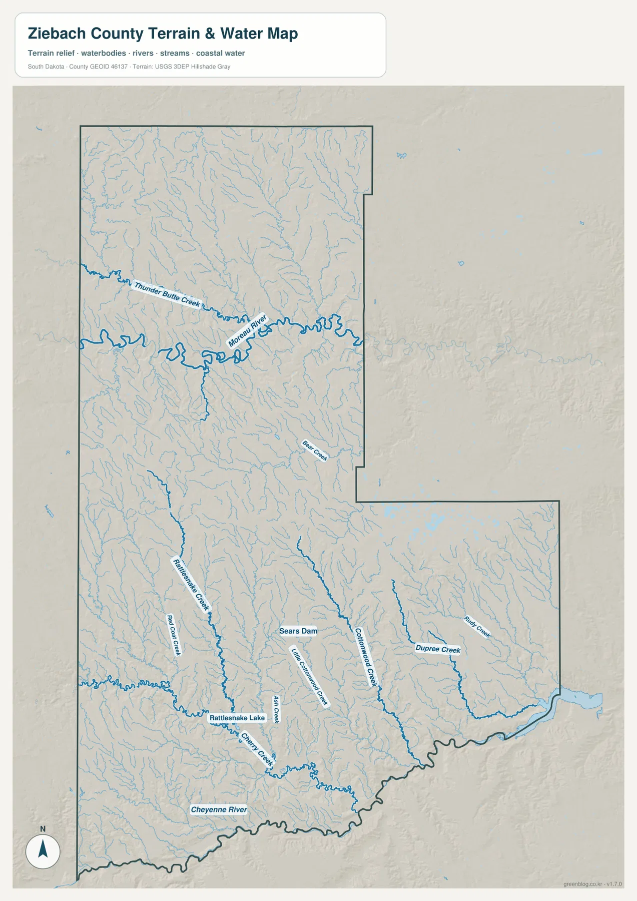
This is a geographic water reference rather than a flood map or navigation product. A blue stream line does not show present water level, flood probability, depth, public access, or navigability. The Cheyenne River follows the county edge for a long distance, but exact legal boundary questions still require authoritative boundary data. Used within those limits, the map is particularly helpful for tracing named waterways and comparing them with roads and terrain.
Lower river corridors cut through broad areas of higher ground
The elevation legend reports an actual county range of about 484 to 831 meters, with a mean of 691 meters. Green represents lower terrain, while tan and brown indicate progressively higher ground. The clearest low corridor follows the Cheyenne River across the south and southeast. A second lower band follows the Moreau River through the northern half. Those two river valleys are easy to recognize even before the stream labels are added.
Higher terrain is especially visible across the northwest and along parts of the northern edge. Additional high ground extends through the interior and southwest, but narrow green valleys cut into it where smaller streams descend toward the major rivers. Comparing the elevation map with the terrain-and-water map makes the relationship clear: many tributaries occupy the lower cuts that branch away from the Moreau and Cheyenne corridors. Ziebach County therefore appears as a landscape of broad uplands repeatedly divided by river and creek valleys rather than as one uniform plain.
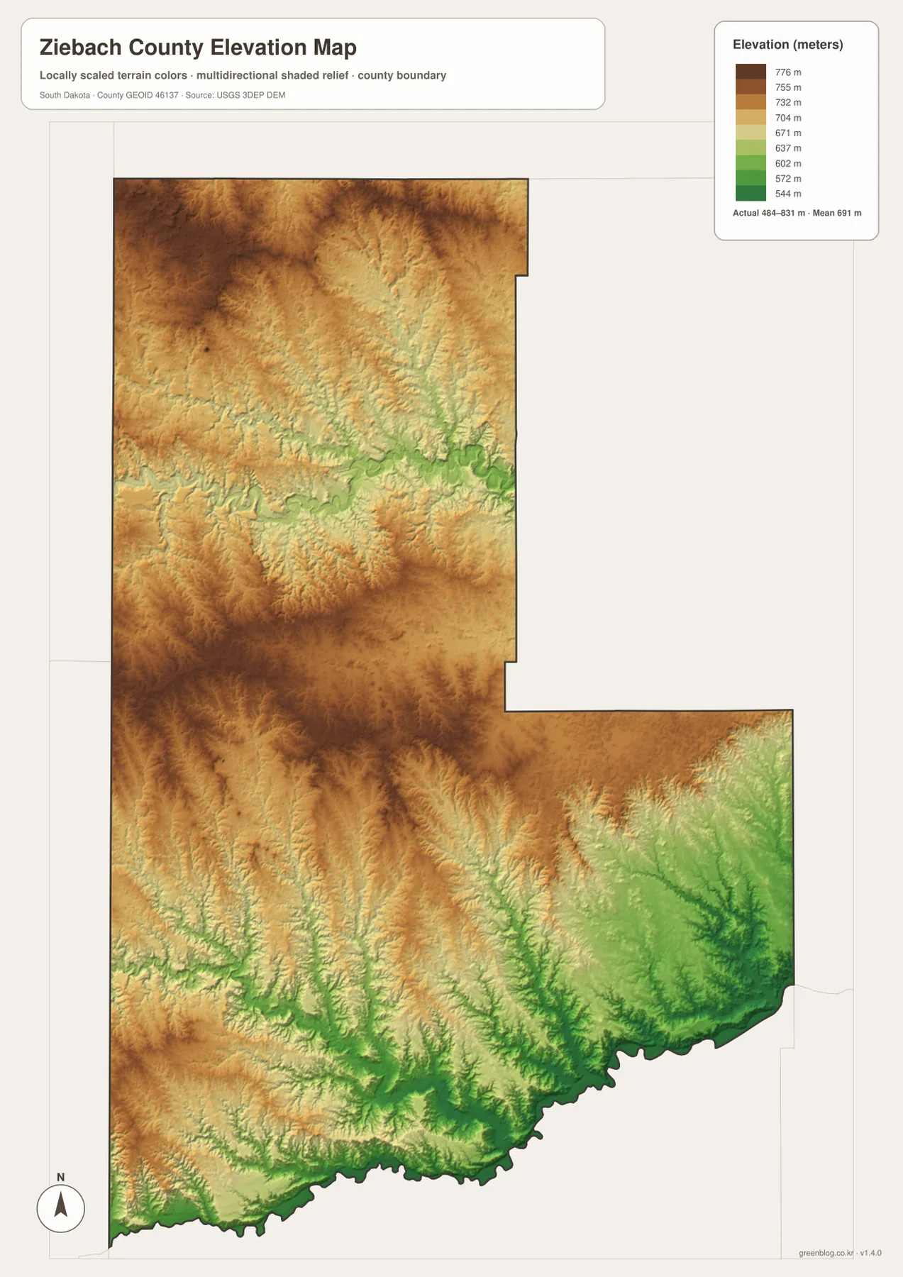
The elevation surface is intended for countywide comparison, not for survey-grade measurement. Elevation can vary within a single color band, and small ridges or cuts may be generalized at this map scale. The image is useful for explaining which parts of the county are relatively high or low, but construction, engineering, drainage design, and precise site work should use original elevation data or a professional survey.
Choose the map that matches the question you need to answer
The general county map is the best starting point when roads, the boundary, and nearby place labels matter. The city view is cleaner when the goal is to compare Eagle Butte and Dupree without a dense road layer. For named rivers and creeks, the terrain-and-water view carries the most useful detail. The elevation map is the better companion when the question is why the river corridors sit below the surrounding uplands. Using the maps selectively keeps the information readable and avoids forcing unrelated labels into a single figure.
The WebP images in the article are optimized for quick viewing on the page. For printing, presentations, or closer examination of labels, download the high-resolution JPG files from the ZIP below. The archive contains the same four map themes as separate files, so you can use only the views needed for a project. When resizing or cropping a map, keeping the county boundary, legend, and orientation marker visible will make the result easier for another reader to understand.
Know what the supplied maps leave out
The general map emphasizes major roads, streams, boundaries, and selected place labels, so it does not contain every local road or building. The numbers on the city view belong to the supplied map and should not automatically be treated as the latest population estimates. The water map does not measure flood risk or water depth, and the elevation map does not replace a site survey. Address research, land ownership, construction, emergency planning, and legal boundary questions should be checked against current authoritative sources designed for those purposes.
The supplied maps and the current county article both point to Dupree as an important reference for county orientation, and the official Ziebach County website identifies county offices in Dupree. That connection is useful for understanding why the location stands out on the map, but this page is not meant to replace official administrative information. For current statistics or county services, consult the county website and the relevant federal or state source directly.
Frequently Asked Questions
What is the quickest way to find Dupree on the Ziebach County maps?
Start with the general map and find the central Road 212 corridor where Road 65 crosses it. The Ziebach County Courthouse label appears nearby, and the city map marks Dupree in the same general area. Using the two maps together gives both the road context and the simplified place location.
Which map is most useful for comparing the Moreau and Cheyenne rivers?
Use the terrain-and-water map for names and drainage lines, then compare it with the elevation map. The Moreau River crosses the northern half and the Cheyenne River follows the southern edge, while the elevation colors show that both corridors occupy lower terrain than much of the surrounding upland. The water map is not a flood-risk or depth map.
Can the 484–831 meter elevation range be used as an exact site measurement?
No. The displayed range is useful for countywide comparison, not for survey-grade elevation at a specific parcel, building, or road site. Exact work should rely on original USGS elevation data or a professional survey appropriate to the project.
Map File Information
Download the high-resolution Ziebach County JPG files in one ZIP. The county, city, terrain-and-water, and elevation maps are stored as separate files.
- Included Files: county map, city map, terrain-and-water map, elevation map
- File Type: ZIP containing 4 high-resolution JPG files
Related Maps
Sources and reference data
- Official Ziebach County website – county office and administrative information.
- U.S. Census Bureau TIGER/Line Shapefiles – reference source for county boundaries and geographic data.
- USGS National Hydrography – official reference for rivers, streams, and hydrographic data.
- USGS 3D Elevation Program – elevation data and 3DEP program information.
Green Map creates custom-edited map images using open geographic data sources such as geoBoundaries, Natural Earth, OpenStreetMap, and government open data.
These maps are edited visual materials, not raw data files, and are provided for education, documents, presentations, and graphic reference.