You can download four high-resolution JPG maps of Jones County, South Dakota, in one ZIP from the file box below. The page also provides browser-friendly WebP versions that cover county roads and boundaries, the two ranked cities shown in the city map, named rivers and creeks, and countywide elevation. Murdo is the easiest starting point: it sits near the south-central part of the county along I-90, Draper lies farther east, and the White River follows the irregular southern edge. The elevation map adds a strong relief contrast, with an actual countywide range of about 498 to 765 meters and a mean near 630 meters.
Jones County is not a map where the main places are spread evenly in every direction. Most of the prominent place and road labels cluster along the southern travel corridor, while the northern half is dominated by smaller roads, stream valleys, and open terrain. The four maps therefore work best when they are read together: the county map establishes the road framework, the city map strips the settlement pattern down to Murdo and Draper, the water map explains the network of valleys, and the elevation map shows how much higher the central-southern interior stands above many of those valleys.
Table of Contents
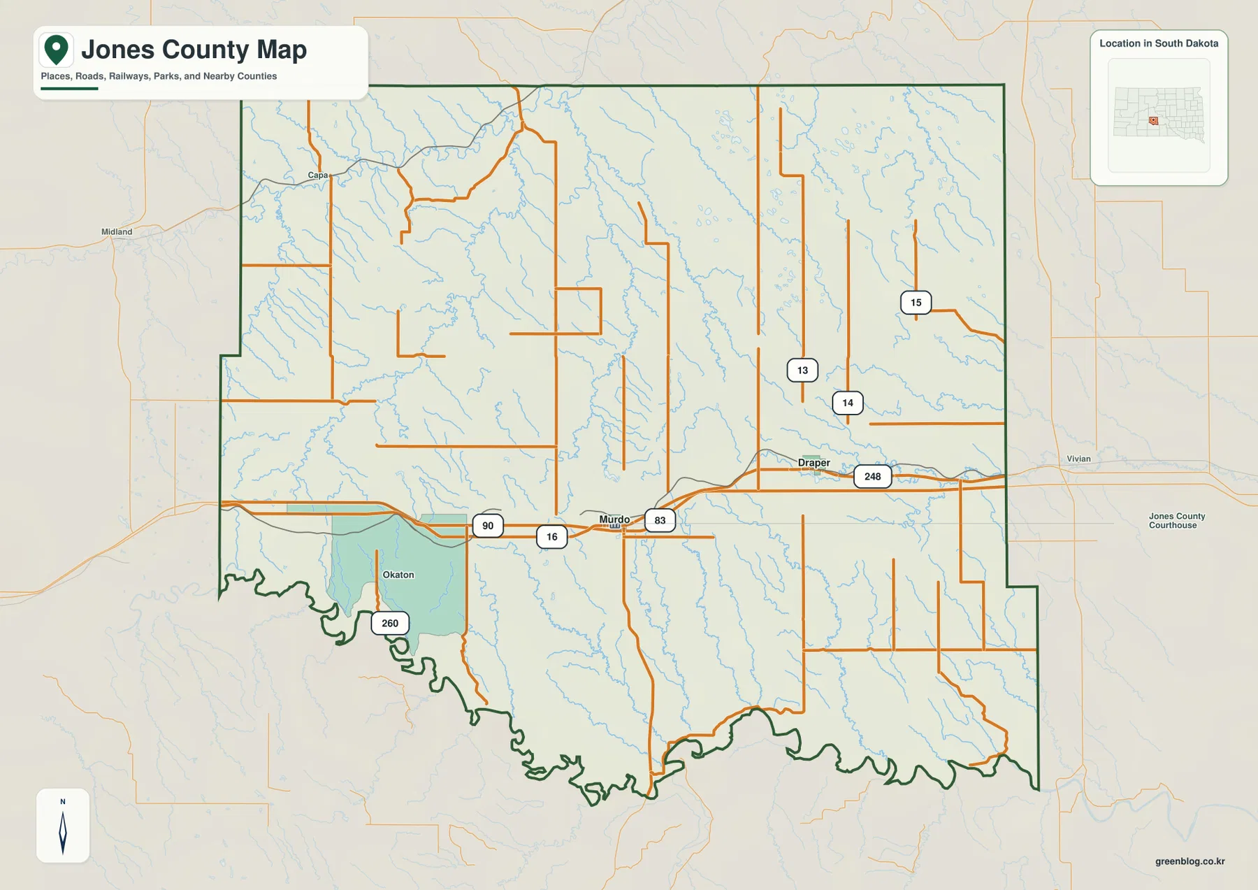
Murdo as the road anchor on the county map
I-90 is the easiest feature to trace on the road-and-boundary map because it runs across the southern part of Jones County and passes directly through Murdo. Draper appears to the east along the same general corridor, while Okaton is marked to the west. Near Murdo, the north-south route labeled 83 meets the interstate, and Highway 248 is visible on the eastern side near Draper. Several numbered routes also appear farther north and northeast, but they do not form the same simple east-west line as the southern corridor.
The county outline changes character as it moves around the map. Long straight sections define much of the north and east, while the southern edge bends sharply in and out. The White River lies close to that uneven southern boundary, so comparing the road map with the water map helps explain why the bottom of the county looks so different from the top. Labels around the outside point toward Haakon, Stanley, Lyman, Tripp, Jackson, and Mellette counties, which makes the page useful for placing Jones County within central South Dakota. The outline is a county reference, however, not a parcel or property-boundary map.
Why the city map is intentionally sparse
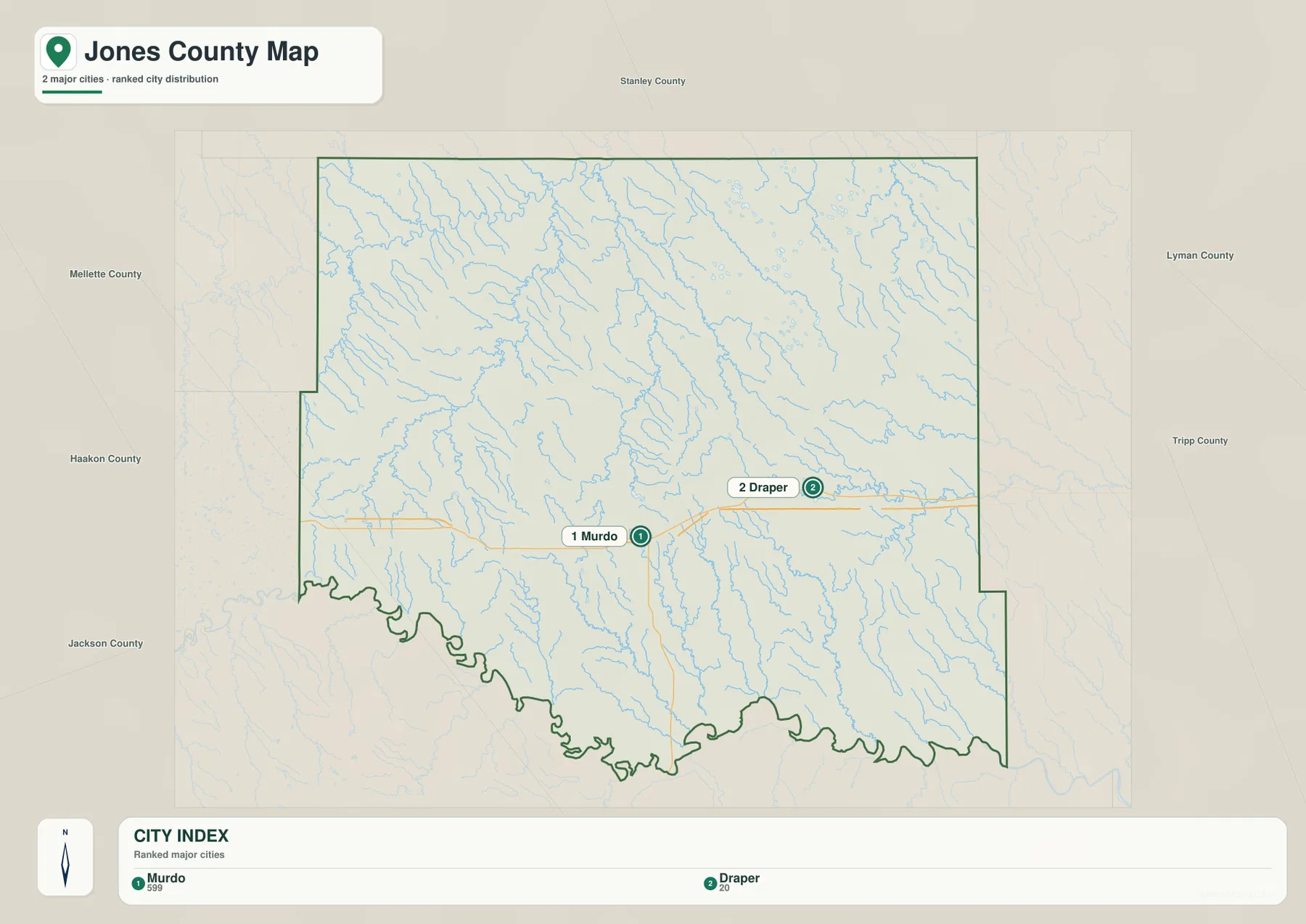
The city-distribution map removes most of the road detail and highlights only two ranked places: Murdo and Draper. Murdo is marked as the first city and Draper as the second, making their relative positions easy to compare without the visual noise of the full county map. Murdo sits closer to the south-central part of the county, while Draper is clearly east of it. The large northern area contains no additional ranked city marker on this version, which reinforces how strongly the page’s main settlement references are concentrated toward the south.
This particular city map does not draw a connector line between Murdo and Draper and does not print a mileage value. That distinction matters because some county city maps in the same project include straight-line measurements, while this one does not. Use the Jones County city map to compare direction and relative location only. If you need driving distance, travel time, or a route between the two places, consult current road-routing information rather than estimating a number from the image.
White River valleys and the north-to-south creek network
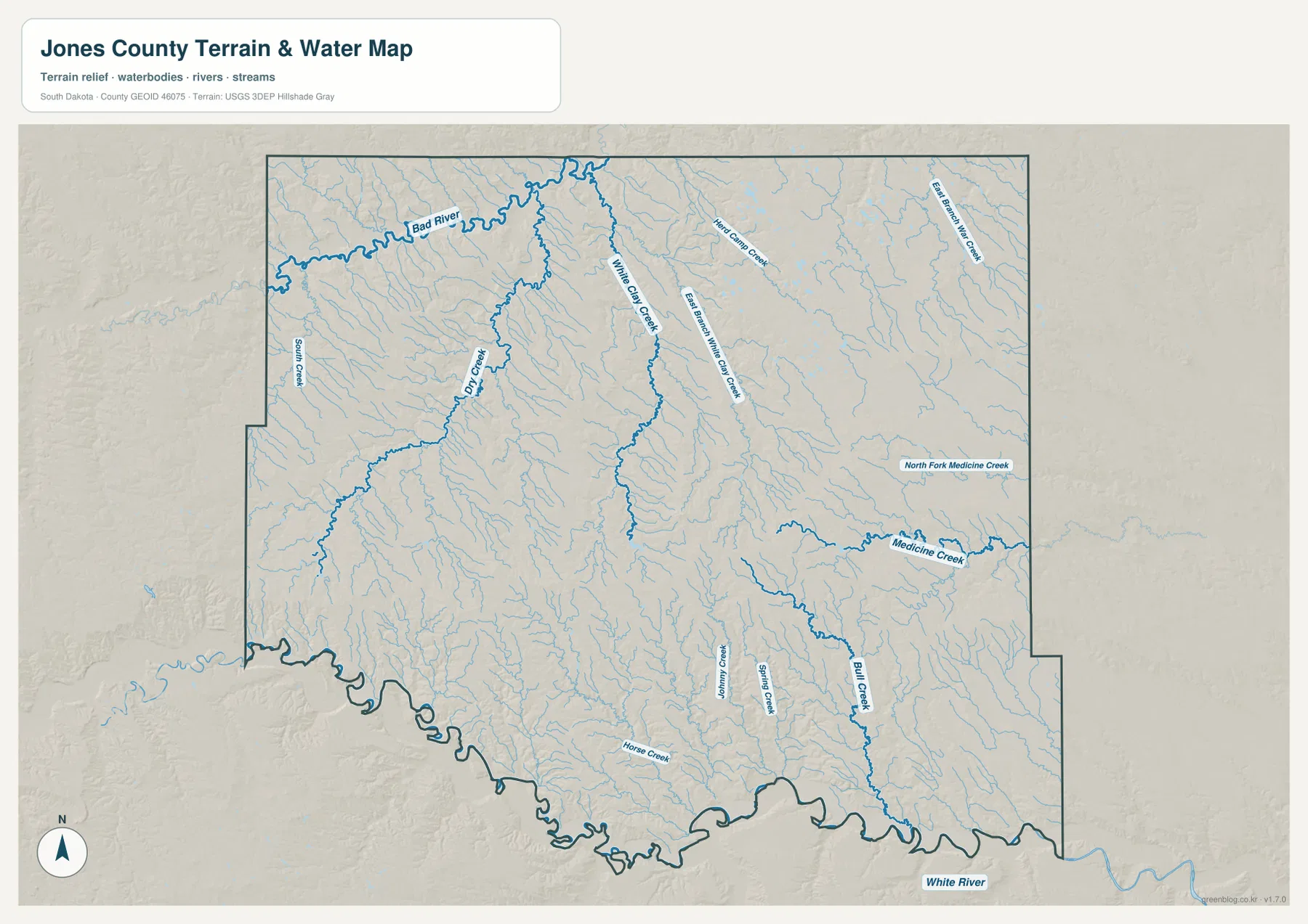
The terrain-and-water map gives Jones County a much more textured appearance than the city map. The White River is the strongest water feature along the south, while a web of smaller streams cuts across the interior. Named features include Dry Creek, White Clay Creek, East Branch White Clay Creek, North Fork Medicine Creek, Medicine Creek, Bull Creek, Horse Creek, Spring Creek, and Cottonwood Creek. The Bad River label is also visible near the northern side of the map, helping place the upper drainage beyond the county’s southern White River system.
Several of the named creeks run through long, narrow valleys that can also be recognized on the elevation map. White Clay Creek and its eastern branch descend through the central-northern interior, while Medicine Creek crosses the eastern half and Bull Creek continues south toward the White River side of the county. Numerous unnamed tributaries fill the spaces between the larger labels. The map is useful for locating rivers, creeks, and valley directions, but it is not a flood-hazard product. It does not show flood probability, water depth, current stream stage, or legal restrictions.
Where the 498–765 meter relief stands out
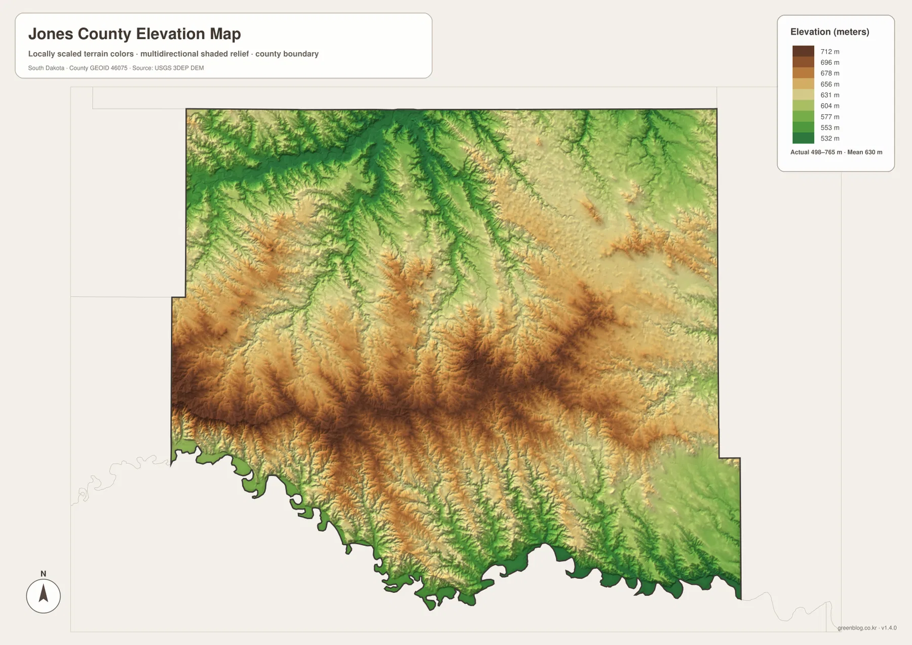
The elevation map reports an actual Jones County range of roughly 498 to 765 meters, with a mean near 630 meters. The strongest high-ground colors form a broad band across the central-southern and southwestern interior. In contrast, lower green tones appear through much of the north and along the incised valleys near the White River and its tributaries. The county therefore does not read as a single flat prairie surface on this map; ridges and drainage cuts repeatedly interrupt the terrain.
The contrast is especially easy to see along the southern half. High brown-toned uplands sit close to lower river and creek valleys, producing sharp local changes in relief. Farther north, lower corridors branch through the map in a pattern that closely matches the stream network. The generalized elevation surface is excellent for broad comparisons—such as identifying where the central high ground sits relative to the White River—but it is not a survey. A precise elevation for a road point, building site, or parcel requires the underlying elevation data or field measurement.
Choosing the right Jones County map for the task
For roads and orientation, start with the county map and use Murdo as the anchor. From there, I-90 leads east toward Draper and west toward Okaton, while Route 83 gives a north-south reference through Murdo. If your question is simply where the two ranked cities lie, the city map is faster because it removes most other detail. Matching Murdo between the two maps makes it easy to switch from a simple settlement view back to the road network without losing your place.
For natural features, begin with the White River on the terrain-and-water map and then follow Medicine Creek, White Clay Creek, or Bull Creek into the interior. Switching to the elevation map at the same location shows whether the stream occupies a lower valley and how close it lies to the higher central-southern ground. The browser images are convenient for reading labels online, but the original JPG files are better for A3 printing, classroom work, presentations, or close inspection of small road and creek names.
Frequently Asked Questions
Does the Murdo–Draper city map include a mileage measurement?
No. The city-distribution map marks Murdo and Draper but does not connect them with a line and does not print a mileage number. It is useful for seeing that Draper lies east of Murdo, but actual driving distance and travel time should come from current road-routing information.
Can the White River and creek map be used to judge flood risk?
No. The terrain-and-water map identifies the White River, Medicine Creek, White Clay Creek, Bull Creek, and other drainage features, but it does not provide flood probability, inundation depth, live water levels, or regulatory flood zones. Use an official flood or hydrology product for decisions that depend on those details.
Is 498–765 meters the exact elevation of every point in Jones County?
No. That is the broad countywide range shown by the elevation map, and the map reports a mean near 630 meters. The surface is intended for comparing higher ridges and lower valleys. Exact elevation at a specific property, road location, or structure requires the underlying elevation dataset or a survey-grade measurement.
Map File Information
The ZIP below contains the original Jones County road-and-boundary map, city-distribution map, terrain-and-water map, and elevation map as four high-resolution JPG files.
- Printable Size: 3638 × 2572 px each
Related Maps
Sources and references
- U.S. Census Bureau TIGER/Line Shapefiles – Official geographic reference data for county boundaries, roads, and place features.
- USGS National Hydrography – Official hydrography information used to reference the White River, creeks, and other water features.
- USGS 3D Elevation Program – Official elevation information used for broad terrain and height comparisons.
Green Map creates custom-edited map images using open geographic data sources such as geoBoundaries, Natural Earth, OpenStreetMap, and government open data.
These maps are edited visual materials, not raw data files, and are provided for education, documents, presentations, and graphic reference.