You can download the high-resolution JPG maps for Jackson County, South Dakota, from this page as one ZIP file. If the county is unfamiliar, start with Kadoka, then use the White River as the main geographic reference through the middle of the county. The four WebP images in the article are sized for quick viewing online, while the download package contains the larger originals for printing, presentations, or closer inspection.
Jackson County has a strong north-to-south contrast. The area around Kadoka and the northern road network is comparatively open, while the land south of the White River becomes more deeply cut by creeks, draws, and higher Badlands terrain. Interior is an important reference in the southwest, and the city-connections map also places Belvidere and Cottonwood around Kadoka so the principal directions are easy to understand before moving to the more detailed maps.
Table of Contents
Start at Kadoka to make sense of the roads and the unusual county outline
The county map shows that Jackson County is not a simple rectangle. Its northern section is broad and fairly regular, but the western boundary steps inward through the middle before widening again farther south. That shape matters when locating places: Kadoka sits in the northern part of the county, while Interior lies well to the southwest in a very different landscape. Along the east, portions of the county edge also lie close to bends in the White River, so straight administrative lines and natural features appear side by side.
Several numbered routes help orient the map. The 73 and 90 markings are visible around the Kadoka area, while 240 and 377 are important references toward Interior and the Badlands. Route 44 also appears in the southwestern part of the county, with additional numbered roads including 14 and 63 elsewhere on the map. These labels are useful for finding locations, but the map is not a live traffic product and does not show current construction, closures, surface conditions, or travel times.
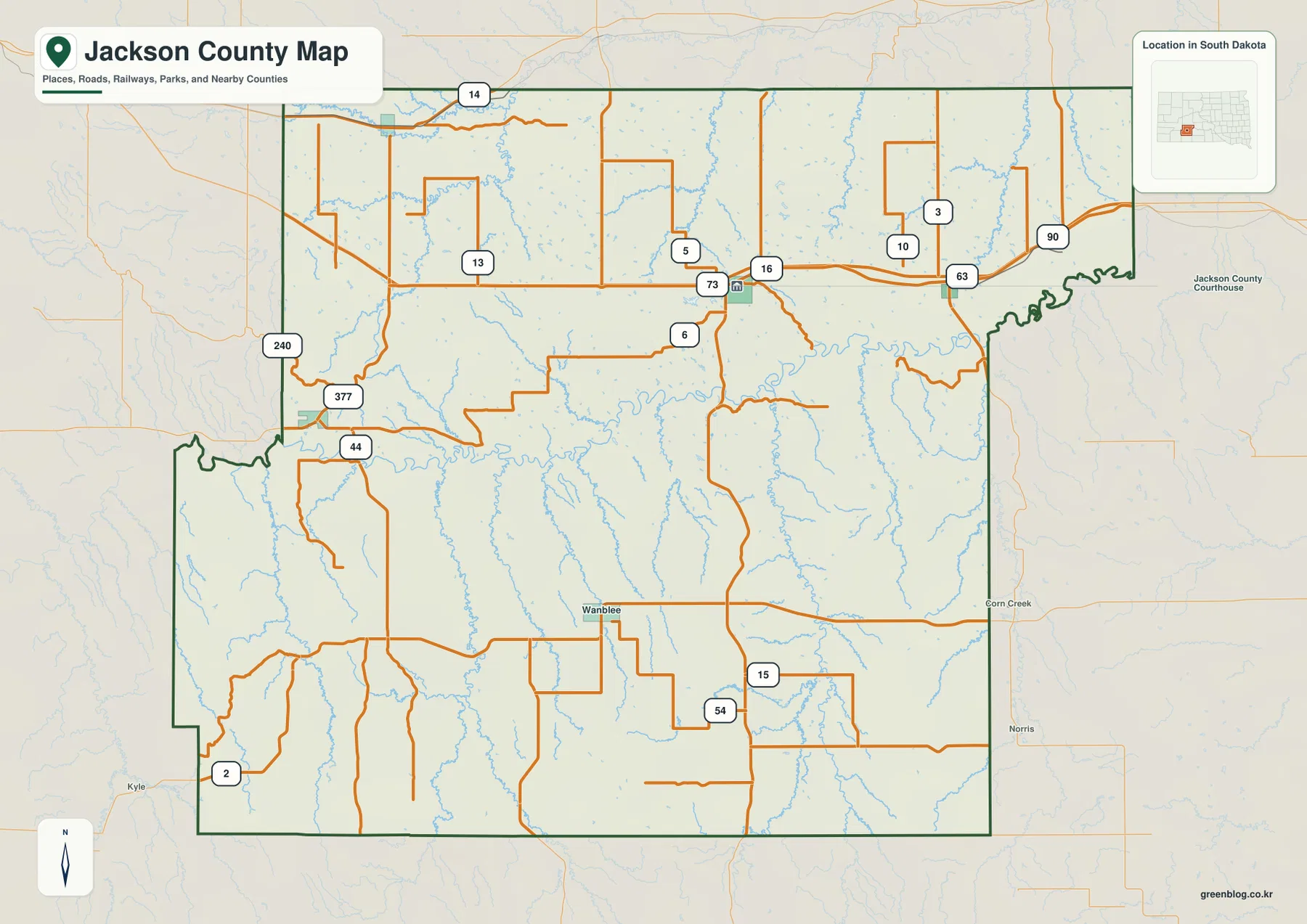
Interior is especially useful for connecting the county map with the Badlands. The National Park Service material included in the source package describes the Interior Entrance in connection with SD 377 and identifies Highway 240 as part of the Badlands Loop Road approach. Those references match the route numbers visible near Interior on the county map. For an actual trip, however, current National Park Service and road information should be checked because access conditions can change.
Belvidere, Cottonwood, and Interior spread away from Kadoka in three different directions
The city-connections map strips away most of the road detail and makes the settlement pattern easier to see. Kadoka acts as the central reference point. Belvidere lies to the east, Cottonwood to the northwest, and Interior to the southwest. Because the three places do not fall along one corridor, this simplified view is useful before returning to the county map and matching each town with nearby roads and terrain.
The map also labels straight-line distances from Kadoka. Belvidere is shown at about 12 miles, Cottonwood at about 22 miles, and Interior at about 25 miles. These are point-to-point measurements rather than driving distances. A road route can be longer because vehicles must follow the available highway and local-road network, so the values should not be used as substitutes for current routing information or travel-time estimates.
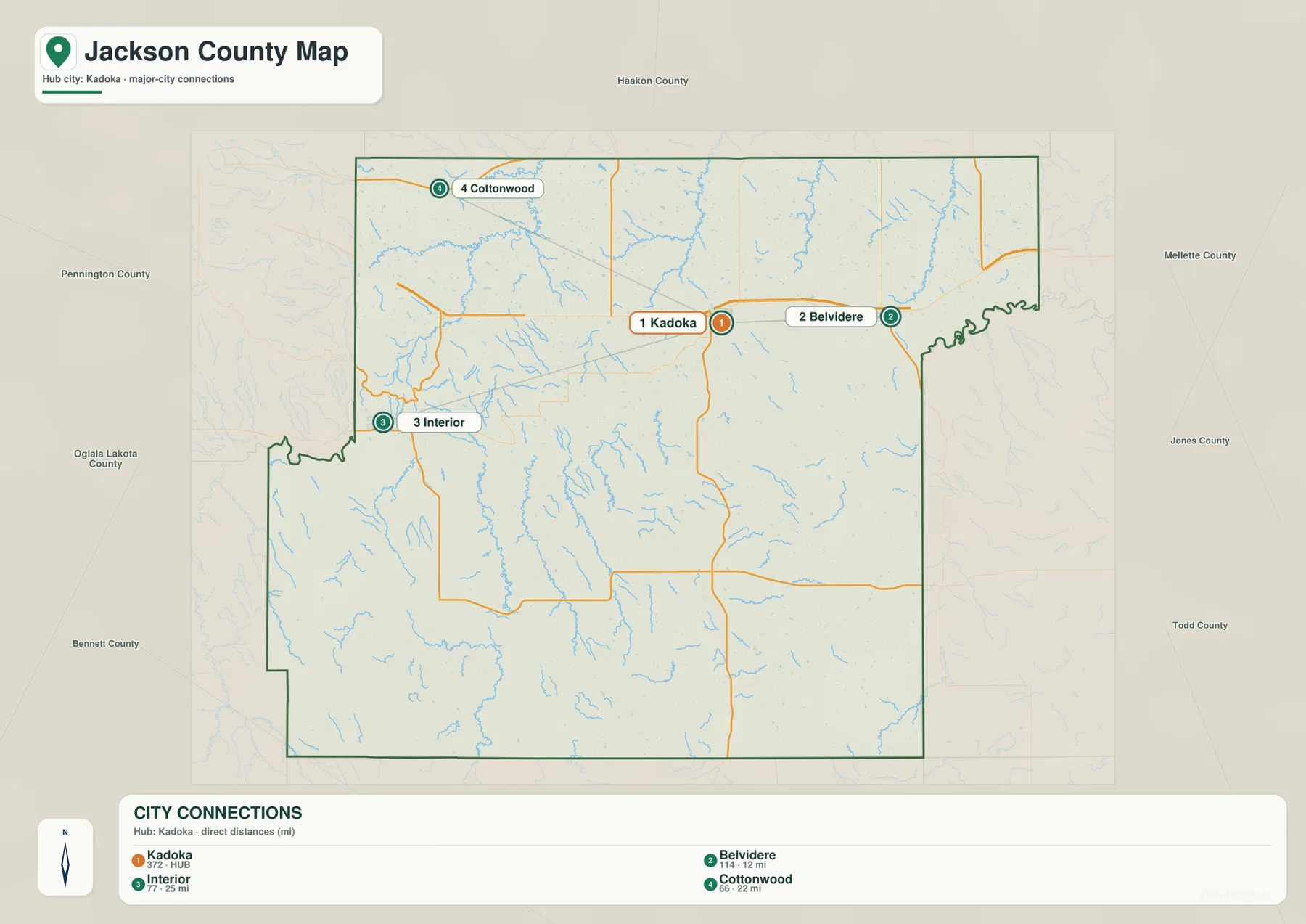
Using this map together with the county map makes the locations more meaningful. Kadoka and Belvidere belong to the northern part of the county, while Interior is a useful reference for the White River south side and the Badlands approach. Cottonwood sits off to the northwest. The city map is not a population chart and does not rank communities by size; its purpose is simply to show direction and approximate straight-line separation.
The White River divides the county and gathers a different set of tributaries on each side
The White River is the most prominent water feature on the terrain-and-water map. It enters from the west and winds eastward across the county slightly south of center. Numerous smaller streams meet it from both sides, making the river a practical reference line for understanding the rest of Jackson County. Once the White River is located, the northern and southern drainage features are much easier to separate.
North of the river, South Fork Bad River runs across the county, Cottonwood Creek appears near the northwestern side, and Yellow Creek is labeled in the northeast. Kadoka Lake is also shown in the northern portion. South of the White River, the named creeks become more prominent: Bear-in-the-Lodge Creek, Eagle Nest Creek, Cuny Creek, and Pass Creek cut through separate valleys toward the main river. Red Stone Creek and Red Rock Pond appear farther east, while Poor Bear Lake is labeled in the south-central area.
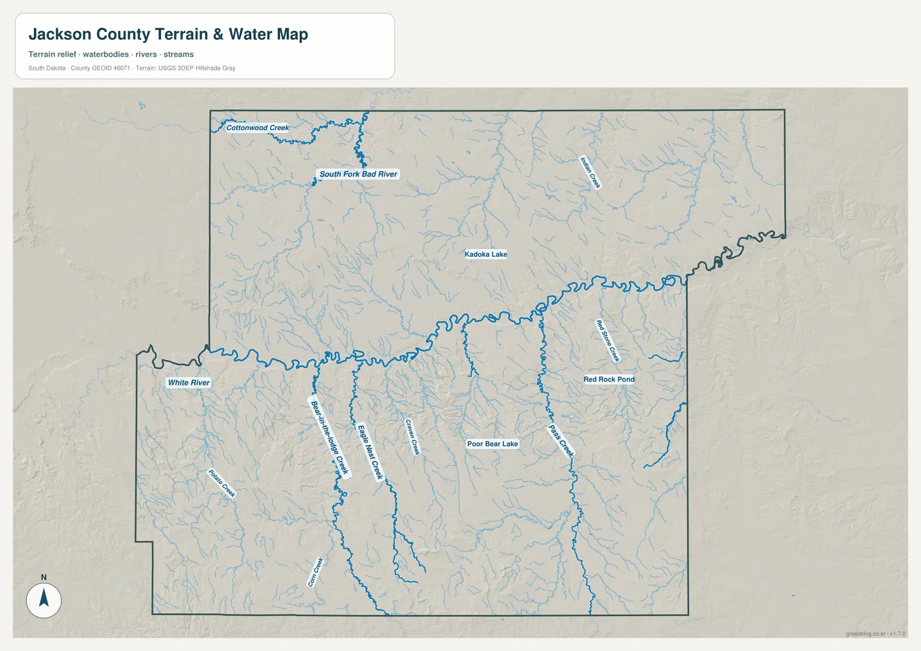
The blue lines should be read as mapped hydrographic features, not as a guarantee that every small channel carries the same amount of water throughout the year. The map also is not a flood-hazard map, property-boundary survey, or source for water depth and flow measurements. Anyone making a safety, engineering, or property decision should use the appropriate official hydrology or flood data for that purpose.
Low ground follows the White River while the southwest rises into Badlands terrain
The elevation legend gives a countywide range of about 591 to 1,065 meters, with an average near 771 meters. The White River corridor appears as a long band of lower green terrain, and many tributary valleys form narrow lower strips leading toward it. Much of the north is shown in greens and lighter yellow tones, suggesting less abrupt relief than the more rugged areas farther south.
The strongest elevation change appears in the southwest and across parts of the southern county. Orange and brown areas mark higher ridges and uplands, while creek valleys cut back down through them. Comparing the elevation image with the water map is particularly useful around Bear-in-the-Lodge Creek, Eagle Nest Creek, and Pass Creek because the lower valleys align with the drainage lines. The result is a landscape of repeated ridges and cuts rather than one flat high surface.
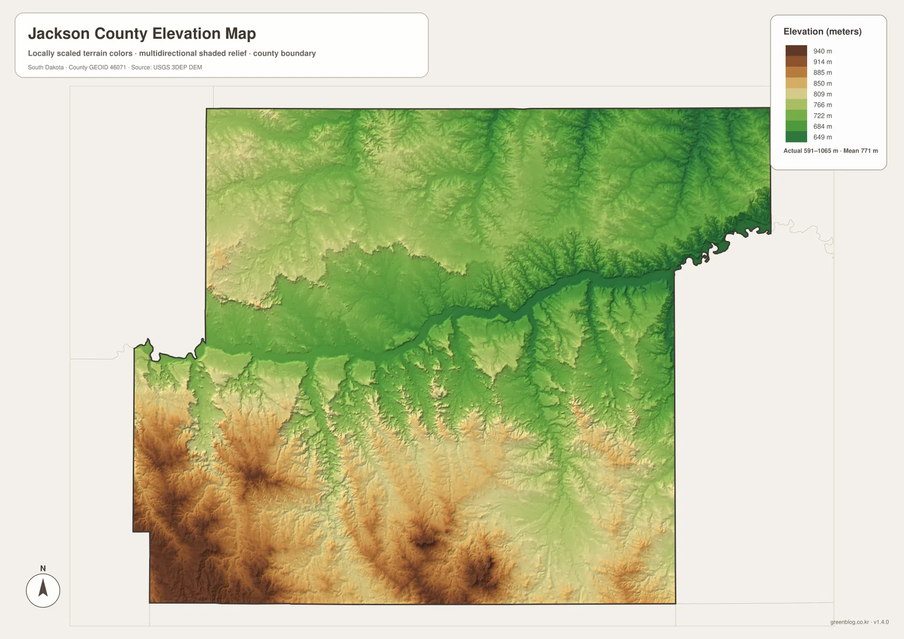
The source package also includes National Park Service material for Badlands National Park, which is relevant to the southwestern Jackson County landscape and the Interior area. The elevation map should still be treated as a regional overview. Its colors and legend do not provide a survey-grade elevation for a house lot, road centerline, or construction site. Detailed work requires original elevation data such as USGS 3DEP and, where appropriate, site-specific surveying.
A simple viewing order connects the towns, White River, and relief without turning the maps into a checklist
For a first look, find Kadoka and the county outline on the general map, then follow the route markings toward Interior. Next, use the city-connections map to place Belvidere, Cottonwood, and Interior around Kadoka without the distraction of smaller roads. After that, trace the White River across the water map and compare the same corridor on the elevation map. This sequence makes the county’s basic geography clear without requiring the reader to study every label at once.
Each map can also stand on its own. The county map is the best choice for roads, boundaries, and several place names. The city-connections map is cleaner when direction and straight-line distance are the main questions. The water map makes the White River and named creeks easier to follow, while the elevation map gives the clearest view of the low river valley and higher Badlands terrain. The WebP versions are intended for on-page viewing; use the original JPG files below when small labels need to be enlarged or when a larger print is required.
Frequently Asked Questions
Are the 12-, 22-, and 25-mile labels from Kadoka driving distances?
No. The city-connections map uses straight-line measurements from Kadoka. Belvidere is shown at about 12 miles, Cottonwood at about 22 miles, and Interior at about 25 miles. Driving distance can be longer because a vehicle must follow the actual road network, so current routing information should be used for travel planning.
Why does the White River appear as a long low band on the elevation map?
The river follows a valley that is lower than many surrounding ridges and uplands. Tributary valleys also appear as lower green lines extending toward the White River. Comparing the water and elevation maps makes it easier to match those low corridors with named creeks.
Can the 591–1,065 meter range be used as the exact elevation of a property?
No. The legend summarizes the broad elevation range across Jackson County and is not a survey measurement for a particular address, lot, building, or road point. Construction, drainage, engineering, and legal survey work require original elevation data and site-specific measurement.
Map File Information
The ZIP below contains the original Jackson County map, city-connections map, terrain-and-water map, and elevation map as high-resolution JPG files.
- Included Files: 4 JPG maps
- Printable Size: 3638 × 2572 px each
Related Maps
Sources and references
- National Park Service – Badlands National Park – official material relevant to the Badlands landscape that extends into the Jackson County area.
- National Park Service – Badlands Directions – official access information for the Interior Entrance, Highway 240, and SD 377.
- U.S. Census Bureau TIGER/Line Shapefiles – official geographic data for county boundaries, roads, and related mapping layers.
- USGS National Hydrography – official hydrography resources for the White River and other mapped water features.
- USGS 3D Elevation Program – official elevation resources and 3DEP information.
Green Map creates custom-edited map images using open geographic data sources such as geoBoundaries, Natural Earth, OpenStreetMap, and government open data.
These maps are edited visual materials, not raw data files, and are provided for education, documents, presentations, and graphic reference.