You can download four high-resolution JPG maps of Hutchinson County, South Dakota from this page in one ZIP file. The page also includes lighter WebP previews for quick viewing: a detailed county road-and-place map, a six-city distribution map, a terrain and water map, and an elevation map. The four views are especially useful for comparing Parkston and Freeman on opposite sides of the county, following the James River through the middle, and seeing broad relief from about 358 to 580 meters.
Hutchinson County is easiest to understand when the James River is used as the main geographic reference. Parkston and Tripp sit to the west, Freeman and Menno are to the east, and several smaller communities are scattered around the river corridor. The county outline also has an unusual angled section in the southwest. South Dakota’s statutory boundary description explains that this segment follows the former Yankton-Sioux Indian Reservation boundary, so the shape is not simply a rectangular survey grid.
Table of Contents
Parkston and Freeman frame the road map from west to east
The detailed county map places Parkston in the west-central area and Freeman near the eastern side, making them useful anchors for reading the rest of the map. Dimock lies north of Parkston, Tripp is farther southwest, Kaylor appears near the southern middle, and Menno is southeast of the James River corridor. Route numbers 44, 18, and 81 appear on the eastern half, while 37 and 25 help orient the southwest and southern parts of the county.
The west has a dense grid of local roads, especially around Parkston and Tripp. In the central and eastern areas, roads share the map with more visible stream valleys and smaller place labels. Old Elm Spring Colony, Milltown, Tschetter Colony, Wolf Creek Colony, and Maxwell Colony are among the additional names printed on the background. These labels make the map more useful for rural orientation, but the image is not a live navigation service and does not show current closures, construction, road surfaces, or travel times.
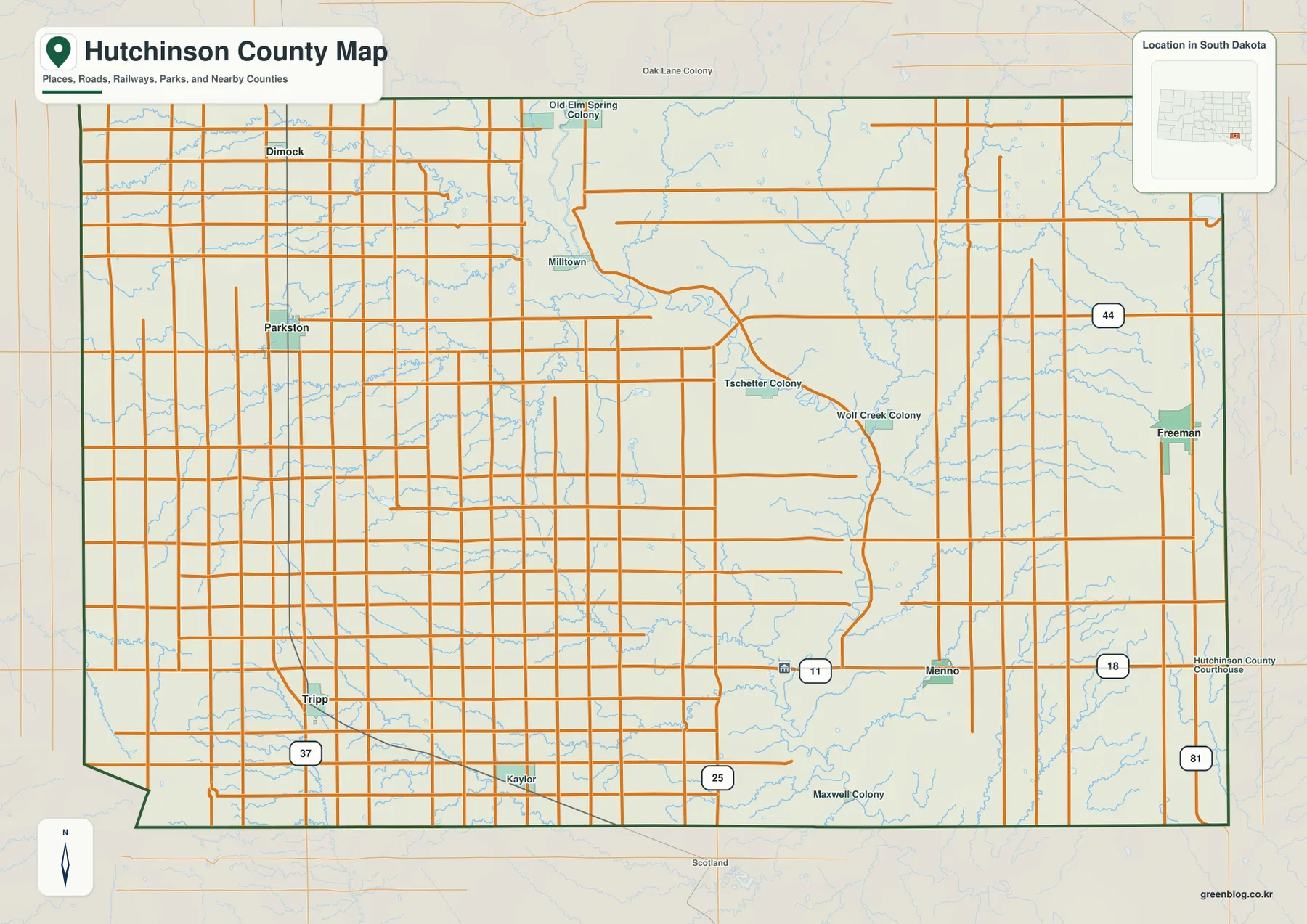
That southwest angle is more than a cartographic detail. South Dakota Codified Law 7-1-34 describes the county line as meeting the former Yankton-Sioux Indian Reservation boundary and then following that line before returning to the southern township boundary. The supplied map is appropriate for general geographic orientation, but it is not a legal survey. Parcel ownership, exact property lines, and legally binding boundary questions should be checked against the appropriate county and survey records.
Six communities are easier to compare without the road detail
The city distribution map removes most road clutter and highlights six communities: Parkston, Freeman, Menno, Tripp, Dimock, and Olivet. Its index orders them in that sequence, with Parkston and Freeman as the two strongest visual anchors. Dimock sits in the northwest, Tripp in the southwest, Menno in the southeast, and Olivet closer to the lower middle of the county near the James River.
This version does not draw connector lines or print mileage values between the cities. It should therefore be used to compare direction and relative position rather than distance. Parkston and Freeman are clearly separated across the county, while Menno and Olivet sit closer to the central river corridor. Dimock and Tripp help define the northern and southern ends of the western settlement pattern.
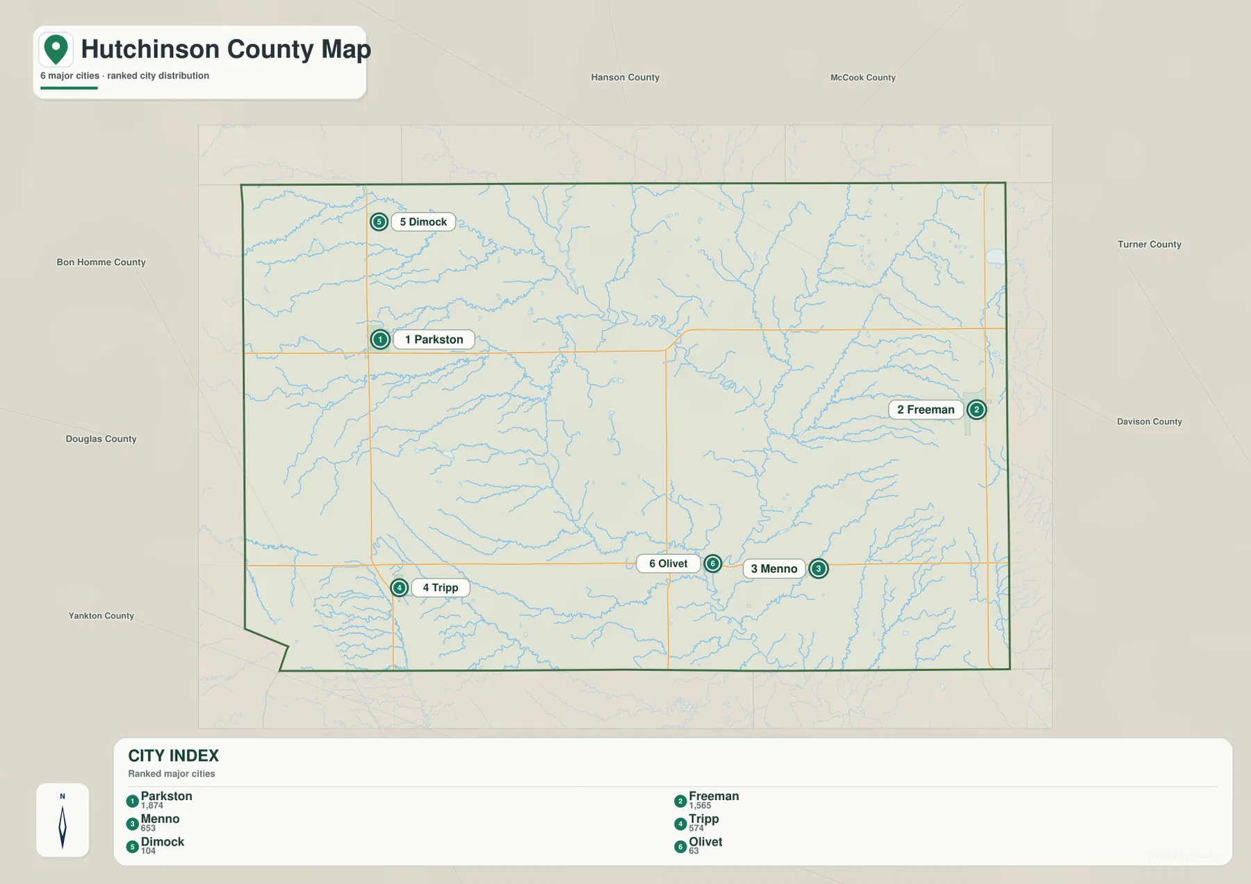
Olivet deserves special attention because its administrative role is not obvious from the city ranking alone. The South Dakota Unified Judicial System lists the Hutchinson County Clerk of Court and courthouse functions in Olivet. That makes Olivet an important destination for county business even though Parkston and Freeman appear more prominent on the simplified city map. Using the city map together with the official court listing helps separate settlement size from administrative function.
The James River gathers named creeks from both sides of the county
The terrain and water map gives the James River the strongest visual emphasis. It enters from the north-central area, bends through the middle of the county, and continues southward past Lake Menno. Several named streams approach from the west. South Fork Twelvemile Creek passes near Lake Dimock, while Coffee Creek and Pony Creek lie farther south. North Branch Dry Creek and South Branch Dry Creek form another set of west-to-east tributaries.
In the southern half, Lone Tree Creek and South Branch Lone Tree Creek converge toward the James River corridor. Wolf Creek is labeled on the eastern side. Tripp Lake is shown near the southwest edge, and Ulmer Lake appears beyond the southeastern side of the county map area. These features make the water map useful for seeing how many smaller drainages feed toward the central lowland rather than simply locating one major river.
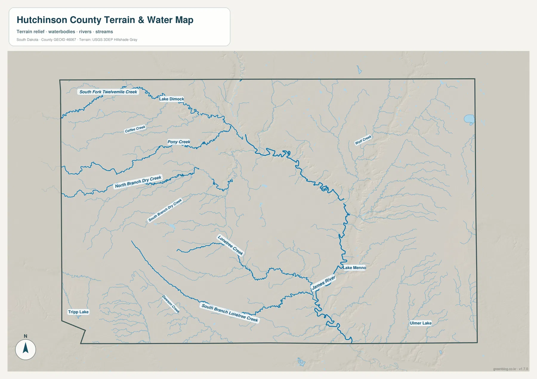
This is a water-reference and terrain map, not a flood-risk, drainage-permit, or engineering product. A blue line shows a mapped water feature, but it does not tell the reader how wide or deep the water is at a given time. Use the map for geographic reference, stream-name lookup, and broad terrain comparison. Flooding, farm drainage, wetland regulation, and other safety or legal questions require the appropriate current official sources.
A 358–580 meter range reveals the low James River corridor
The elevation legend reports an actual county range of roughly 358 to 580 meters and a mean near 424 meters. The lowest colors form a long green corridor through the middle of Hutchinson County, closely matching the James River and its major valley. Once that corridor is identified, the relationship between the water map and elevation map becomes easy to follow: streams descend toward the central low ground from higher terrain on both sides.
The southwest corner contains the broadest area of brown and tan high ground, while another distinctly elevated area appears along the eastern edge. Much of the west and northwest sits above the central river corridor but below the highest ridges. The shaded relief also shows narrow side valleys cutting into the uplands, which helps explain why the water map contains so many named tributaries even though the county is not dominated by large lakes.
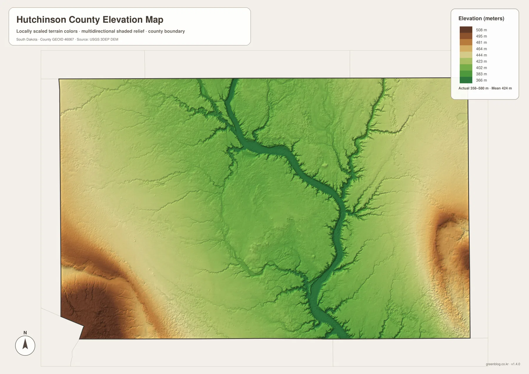
The elevation image is a generalized county-wide surface. It is useful for comparing broad relief, but it should not be read as a precise elevation at a parcel, road crossing, building site, or drainage structure. Surveying, engineering, construction, and farm-drainage design require source elevation data and field measurements appropriate to the specific project.
Choose the map by the question, then use the full-resolution JPGs
Use the detailed county map when the first question is where a community or numbered road lies. It is the best place to orient Parkston, Freeman, Menno, Tripp, Dimock, Kaylor, and the smaller rural labels. Use the city distribution map when you want a cleaner comparison of the six highlighted communities without the road network. Because it has no mileage lines, keep distance questions for a current routing service.
Use the terrain and water map to trace the James River, South Fork Twelvemile Creek, Pony Creek, the Dry Creek branches, and the Lone Tree Creek system. Then compare the same locations on the elevation map to see the low central corridor and higher ground on the southwest and eastern sides. Looking back and forth between those two maps gives a clearer picture than treating the stream names and elevation colors as separate subjects.
The WebP images in the article are sized for efficient online viewing. For closer inspection of small labels, A3 printing, presentations, classroom work, or personal reference, use the original JPG files in the download archive below. The ZIP contains the county map, city distribution map, terrain and water map, and elevation map as four 3638 × 2572 pixel JPG images.
Frequently Asked Questions
Does the city distribution map show the distance between Parkston and Freeman?
No. This city map ranks and locates six communities but does not draw connector lines or print mileage values. It is useful for relative position only. Use a current road service for driving distance, travel time, and route conditions.
Why is Olivet important even though Parkston and Freeman are more prominent on the city map?
The South Dakota Unified Judicial System lists Hutchinson County court and Clerk of Court functions in Olivet. The city map helps locate Olivet near the lower-central part of the county, while the official court page explains its administrative role.
Can the 358–580 meter elevation range be used for surveying or drainage design?
No. The range summarizes broad county relief and does not provide survey-grade elevation for a parcel, field, road, or structure. Engineering, construction, drainage, and legal survey work should use source elevation data and appropriate field measurements.
Map File Information
The ZIP below contains the original Hutchinson County road and place map, city distribution map, terrain and water map, and elevation map as four high-resolution JPG files.
- Included Files: 4 JPG maps
- Printable Size: 3638 × 2572 px each
Related Maps
Sources and references
- South Dakota Legislature – Hutchinson County boundaries – Official statutory description of the Hutchinson County boundary, including the angled segment tied to the former Yankton-Sioux Indian Reservation boundary.
- South Dakota Unified Judicial System – Hutchinson County – Official listing for the Hutchinson County court and Clerk of Court in Olivet.
- U.S. Census Bureau TIGER/Line Shapefiles – Official geographic reference data for county boundaries, roads, and related map features.
- USGS National Hydrography – Official U.S. hydrography resources for rivers, streams, and water bodies.
- USGS 3D Elevation Program – Official USGS information about national elevation data and 3DEP.
Green Map creates custom-edited map images using open geographic data sources such as geoBoundaries, Natural Earth, OpenStreetMap, and government open data.
These maps are edited visual materials, not raw data files, and are provided for education, documents, presentations, and graphic reference.