Bennett County in southwestern South Dakota is easiest to orient from Martin and the highway lines that meet near it. The supplied maps then add a second layer of context: a one-city distribution view centered on Martin, a terrain-and-water view dominated by Little White River and its tributaries, and an elevation surface that falls broadly from higher western ground toward the lower east. This page explains those county-scale relationships and provides the matching high-resolution JPG files in a downloadable ZIP for printing or closer viewing.
A practical starting point is US 18. It approaches from the Batesland side in the west and continues toward Martin, while SD 73 runs south from the Martin area and SD 4 appears farther northwest near Allen. Once those references are familiar, the water and elevation maps become easier to compare because the same county outline is retained across the set. The result is a clear way to move from roads and settlements to named streams, lakes, the reservoir, and the broad west-to-east relief change without treating any one map as a substitute for detailed navigation or survey data.
Table of Contents
Use US 18 and Martin to establish the county reference points
Martin is the clearest place name on the general county map and sits slightly south of the middle of the county. US 18 enters from the west near Batesland and heads toward Martin, providing the strongest east-west road reference in the southwestern half of the map. SD 73 turns south from the Martin area, while Allen appears well to the northwest near SD 4. Finding those three numbered routes first makes it much easier to place the smaller road segments and stream lines that fill the rest of the county.
The general map also shows why Bennett County cannot be reduced to a simple road grid. Fine blue stream lines cross much of the mapped area, especially in the eastern half, and they often outnumber the larger road lines visually. Batesland is shown close to the western side outside the county outline, which helps explain the direction from which US 18 approaches. For a regional handout or a quick orientation to Martin, Allen, the county boundary, and the major numbered roads, this is the strongest first map to use.
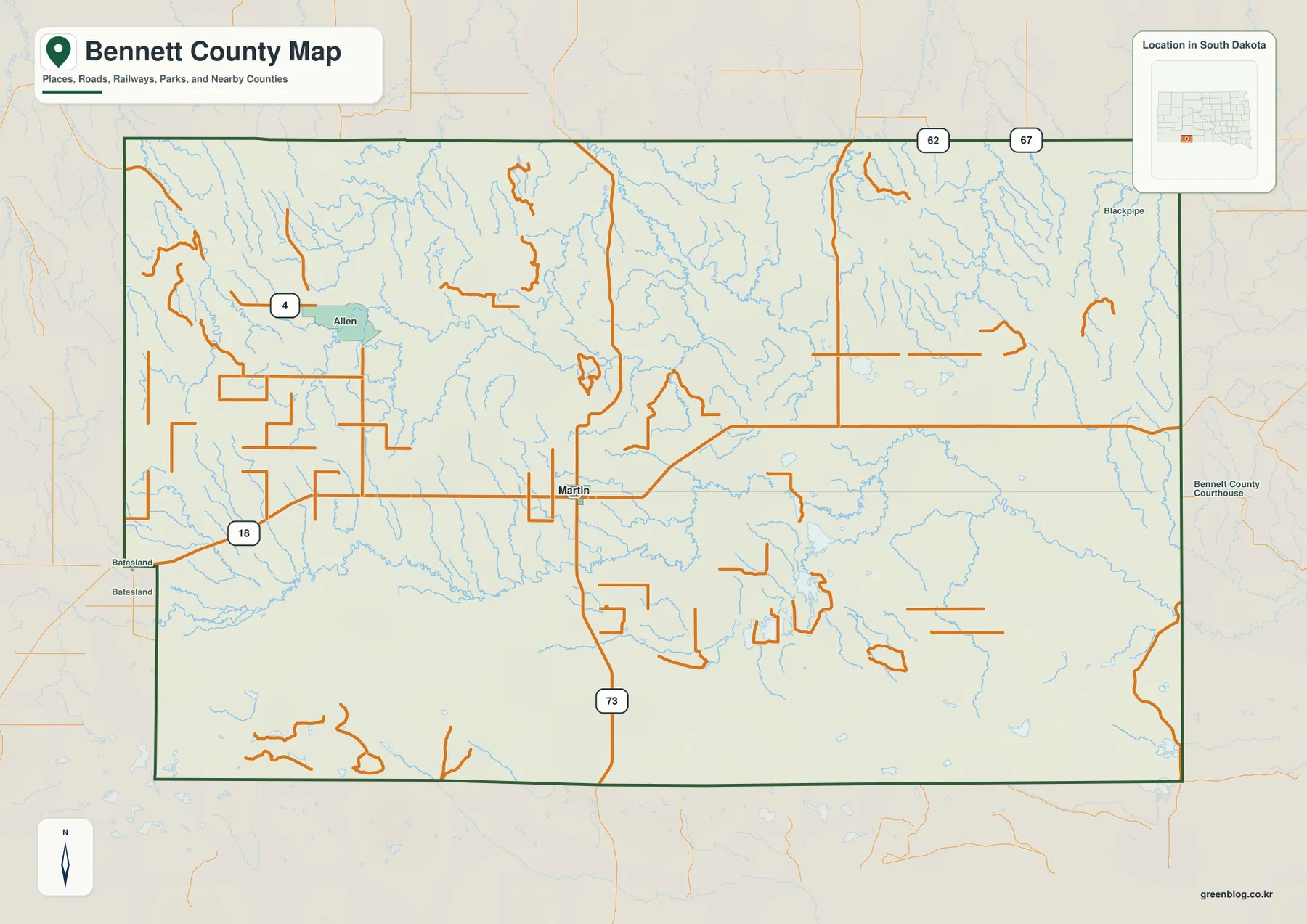
The boundary is mostly straight-sided but includes an inset shape along the southwestern edge, so it is not a perfect rectangle. That same outline appears on the terrain and elevation views and is useful when matching a location from one image to another. Because this is a county-scale reference, the roads should not be read as a live navigation layer or a detailed street map. Current routing, closures, property access, and site-specific travel questions require an appropriate up-to-date source.
The city map deliberately simplifies the settlement picture to Martin
The city-distribution map is much simpler than the general road map. Its CITY INDEX contains one major city, Martin, ranked first with a printed value of 947. That number is used here only as the value shown on the supplied graphic; it is not presented as a new or independently verified population estimate. The more useful message is visual: Martin is the single ranked urban reference and appears near the central-southern part of the county where the general map also shows the most obvious road convergence.
Several neighboring county names sit outside the Bennett County outline and help with orientation. Oglala Lakota County appears to the west, Jackson County to the north, and Todd County and Mellette County on the eastern side. Allen and Batesland, which are useful labels on the general map, do not appear in the one-entry CITY INDEX. That difference is intentional and makes the city view best for emphasizing Martin rather than for inventorying every settlement or comparing city-to-city travel distances.
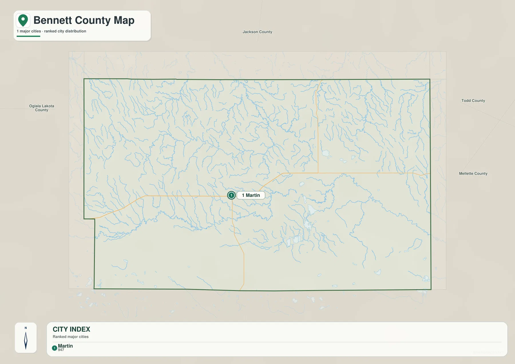
This simplified view becomes more useful when paired with another map. For example, locating Little White River Reservoir on the water map and then returning to the city map makes it easy to see that Martin lies to the west of that east-central water reference. If smaller place names or highway details matter, the general map should take over. The city map is intentionally a location-focused summary rather than a complete settlement or transportation map.
Little White River and the reservoir organize the eastern water features
The terrain and water map shifts attention from roads to drainage. Little White River is the strongest named river feature in the eastern half and continues toward the southeast. Little White River Reservoir lies to its west in the east-central part of the county, with Deadmans Lake immediately north of the reservoir. White Lake and Silver Lake appear farther northeast, while Spring Creek approaches the Little White River area and Pass Creek is labeled closer to the northeastern side. These names create a useful set of reference points for the water-rich eastern half.
The western and central portions have their own named waterways. Bear-in-the-Lodge Creek runs from the west toward the center, and No Flesh Creek is labeled close to the western edge. Lake Creek appears across the southern interior, with Peck Creek farther to the southeast. West Lake, Scotchman Lake, and Clear Lake are also labeled near the lower part of the map. Between the named features, many fine tributary lines show that drainage is spread across the county rather than confined to a single river corridor.
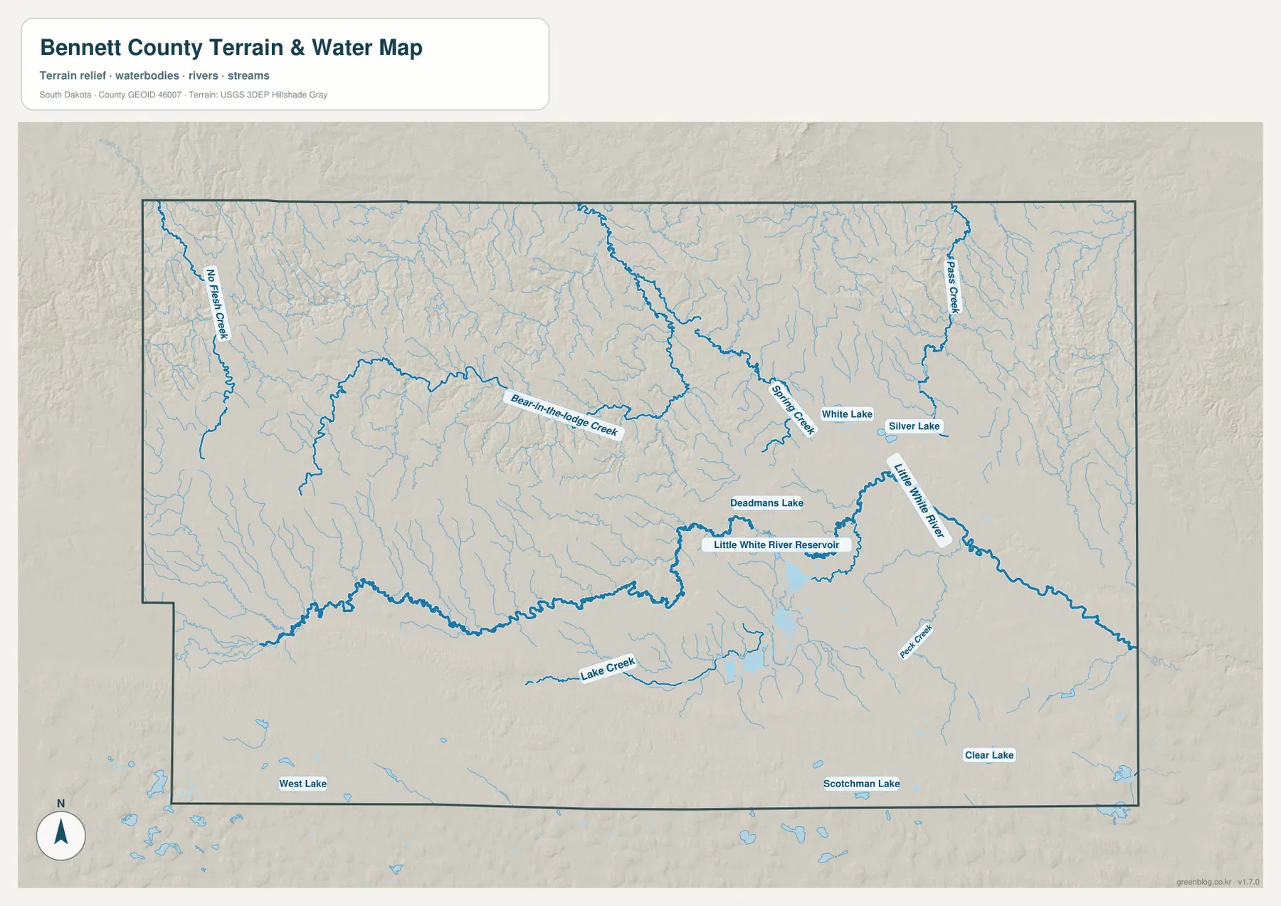
This image is a county-scale location reference for rivers, creeks, lakes, and terrain. It does not map flood-hazard boundaries, legal shoreline limits, property ownership, public access, current reservoir levels, or boating conditions. A stream line indicates where a mapped watercourse is located, not how wide a flood-prone area may be. Any safety, regulatory, or legal question should be checked against the appropriate current official resource.
Elevation colors show a broad drop from the west toward the east
The elevation map reports an actual county range of about 811 to 1107 meters and a mean of about 966 meters. Brown and orange colors cover much of the west and southwest, indicating the higher parts of the county, while yellow and then green become more common toward the center and east. A long lower area in the east-central portion is especially clear and makes the large-scale relief direction easy to recognize without needing to estimate elevation from contour lines.
The western side is not a smooth, uniform plateau. Numerous ridges and valleys create a rougher texture in the northwest and across portions of the southern high ground. The eastern half is lower overall, but it still contains local ridges, shallow valleys, and isolated patches of somewhat higher terrain. A more accurate description is therefore a broad decrease in elevation from west to east with many smaller local variations, rather than a sharp division between mountains and flat land.
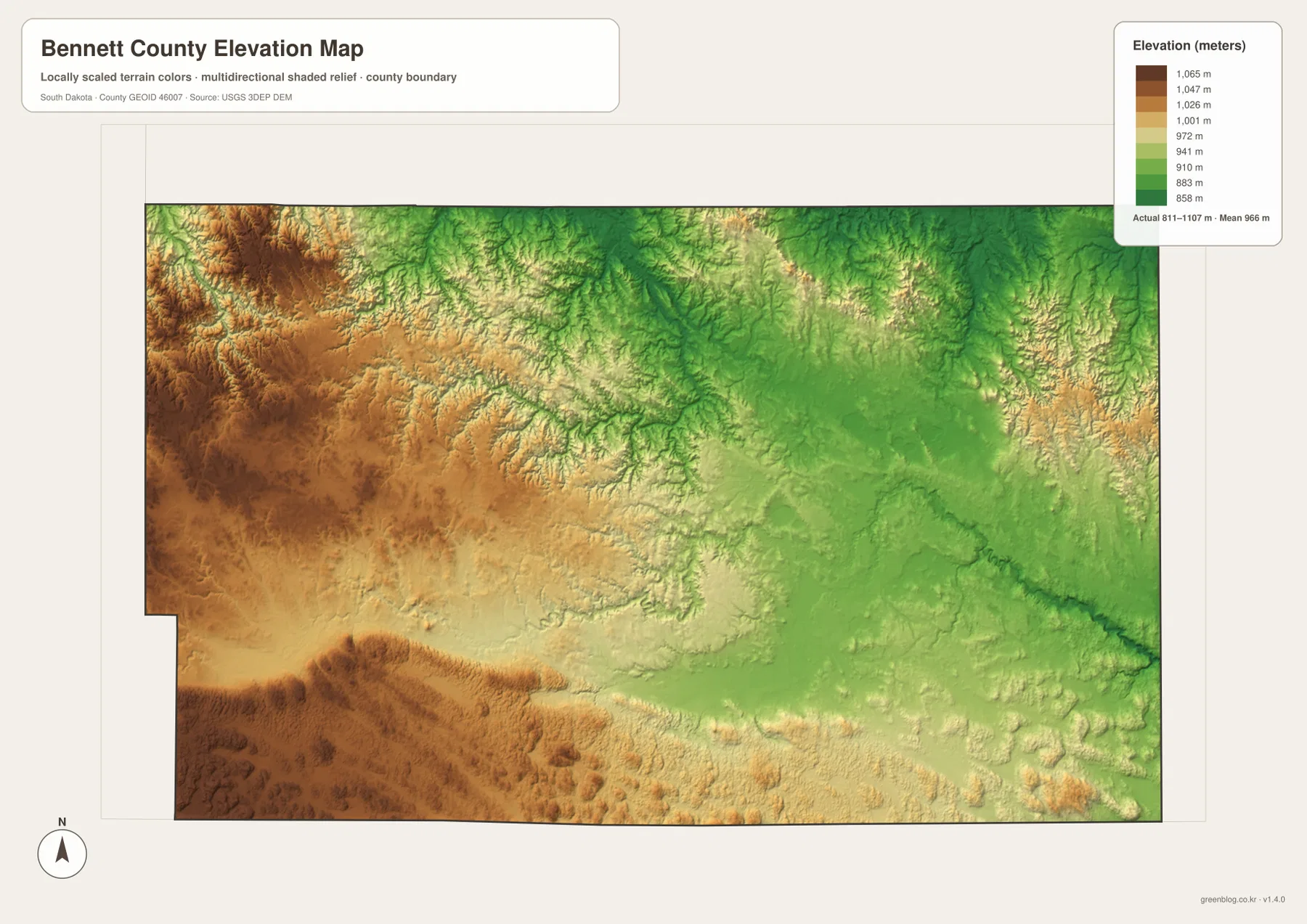
Cross-checking the elevation image with the water map adds context to the Little White River side of the county. The river and reservoir sit within the broad lower-elevation colors of the east, while many western drainage lines cut through generally higher terrain. The two maps are not a survey-grade overlay and should not be used to calculate the exact grade of a stream, the elevation of a parcel, or engineering design values. Site-specific work requires original elevation data or a suitable professional survey.
Cross-reading the maps turns separate themes into one county picture
A good way to use the set is to follow the same place from one image to the next. Start at Martin on the general map and use US 18 as the road reference. The city view then reduces the settlement information to Martin alone, making its position unmistakable. Moving east on the water map brings Little White River Reservoir, Little White River, nearby lakes, and named creeks into focus, and the elevation map shows that much of that same eastern area lies below the warmer-colored western ground.
The western side tells a different story depending on the map. On the general view, Allen and SD 4 are prominent in the northwest and US 18 approaches from the Batesland side farther south. On the water map, No Flesh Creek and Bear-in-the-Lodge Creek become more useful reference features. On the elevation surface, the same western area is recognizable as higher, more strongly dissected terrain. That comparison is more informative than trying to force road, settlement, water, and relief information into a single crowded graphic.
For printing or classroom use, choose the file that matches the question. The general map is the best starting point for Martin, Allen, the county outline, and the main numbered roads. The city map is cleaner when Martin itself is the subject. The terrain and water map works best for Little White River, the reservoir, creeks, and lakes, while the elevation map is the clearest choice for the 811–1107 meter range and the higher-west, lower-east contrast. Pairing the general and water maps or the water and elevation maps can add context without overloading either image.
The WebP images in the article are reduced for browser viewing. The downloadable archive contains the corresponding original JPG files at 3638 by 2572 pixels, which gives more room for printing and zooming. These remain county-scale references rather than parcel surveys, engineering drawings, live navigation products, or emergency flood maps. Use them for regional orientation and visual explanation, and turn to current specialized sources whenever the task depends on precise or time-sensitive information.
Frequently Asked Questions
Which map is best for finding Martin and the main numbered highways?
Use the general county map first. It shows Martin with US 18, SD 73, Allen, and SD 4 in the same view, making it the clearest road-and-settlement reference. The city map is useful as a simpler companion when you want Martin to stand out without the smaller place and road detail.
What water features are labeled around Little White River Reservoir?
The terrain and water map labels Little White River Reservoir and Little White River along with Deadmans Lake, White Lake, Silver Lake, Spring Creek, and Pass Creek in the eastern half. Farther west, Bear-in-the-Lodge Creek and No Flesh Creek provide additional named references. The image is for location and comparison; it is not a flood, access, water-level, or legal-boundary map.
Where is the strongest elevation contrast in Bennett County?
The broadest contrast is between the higher brown and orange terrain in the west and southwest and the larger green lowland area toward the east. The supplied elevation map reports a range of about 811 to 1107 meters and a mean of about 966 meters. Those county-scale values are useful for geographic context but should not replace site-specific elevation measurements.
Sources and reference material
- U.S. Census Bureau QuickFacts – Bennett County, South Dakota
- U.S. Census Bureau TIGER/Line Shapefiles
- USGS National Hydrography
- USGS 3D Elevation Program
Map File Information
The ZIP contains the original high-resolution JPG versions of the Bennett County general map, city map, terrain and water map, and elevation map. Use the archive when you need larger images than the WebP previews shown in the article.
- Included Files: General county map, city map, terrain and water map, and elevation map — 4 JPG files
- File Type: JPG, 3638×2572 pixels each
- Intended Use: Printing, classroom material, presentations, and county-scale geographic reference
Related Maps
Green Map creates custom-edited map images using open geographic data sources such as geoBoundaries, Natural Earth, OpenStreetMap, and government open data.
These maps are edited visual materials, not raw data files, and are provided for education, documents, presentations, and graphic reference.