Download the high-resolution A3 JPG versions of the Aurora County Map set together in a ZIP archive directly from this page. The maps start with Plankinton and the two routes that make the county easy to orient: I-90 running east-west through the White Lake–Plankinton corridor and US 281 running north-south past Stickney. The page also follows Firesteel Creek and the western Platte Creek drainage, then adds a separate elevation view showing a countywide range of about 404 to 612 meters.
Aurora County does not have one compact cluster of large communities. Plankinton sits in the east-central part of the county, White Lake is well to the west, and Stickney lies south of Plankinton. That settlement pattern is easy to understand on the city-connection map, but the road, water, and elevation views reveal different parts of the same story: an interstate crossing the middle, a heavily branched northern drainage around Firesteel Creek, and higher ground concentrated most clearly in the northwest.
Table of Contents
I-90 ties White Lake to Plankinton while US 281 turns south toward Stickney
On the general county map, Plankinton is the easiest place to use as a reference point. I-90 passes just south of town and continues west toward White Lake, creating the clearest east-west line across Aurora County. The highway also provides a useful way to understand the county’s width: White Lake sits near the western side, while Plankinton is much closer to the eastern half.
US 281 follows a very different direction. It runs north-south east of Plankinton and continues through Stickney in the southern part of the county. The map also carries many numbered local roads across the broad rectangular interior, with several north-south and east-west lines intersecting around Plankinton and Stickney. Reading the interstate and US highway first makes those smaller roads easier to place rather than treating the county as a grid of unexplained numbers.
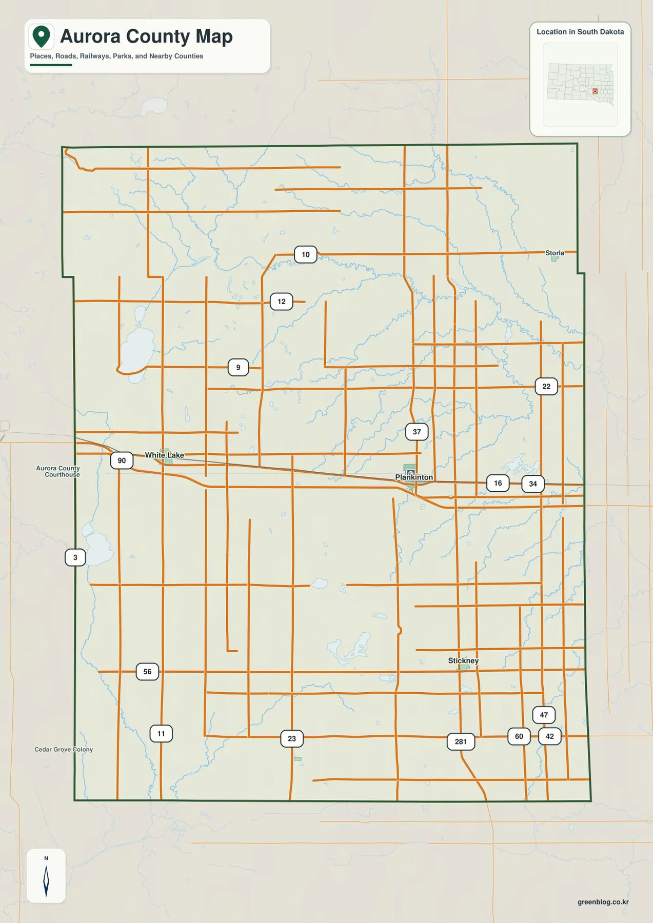
The northeast edge also includes the Storia label, while surrounding county names frame Aurora County on every side. Jerauld County lies to the north, Davison and Sanborn are to the east, Charles Mix and Brule are to the west and southwest, and Douglas County appears along the northwest side. These neighboring labels are useful for orientation, but the map should not be treated as a live navigation product; current road closures and travel conditions require current transportation sources.
Plankinton is the hub: White Lake is 12 miles west and Stickney 9 miles south by straight line
The city-connection map reduces the county to three principal labels and makes their geometry easy to see. White Lake is shown about 12 miles from Plankinton, while Stickney is about 9 miles away. Those values are straight-line distances from the Plankinton hub, not driving distances measured along I-90, US 281, or local roads.
The contrast between the two connections is more important than the numbers alone. White Lake lies almost directly west of Plankinton and follows the same broad I-90 corridor. Stickney is south of Plankinton and aligns much more closely with the US 281 direction. This creates a simple L-shaped pattern among the three communities, which helps explain the county’s road layout before the smaller routes are added back in.
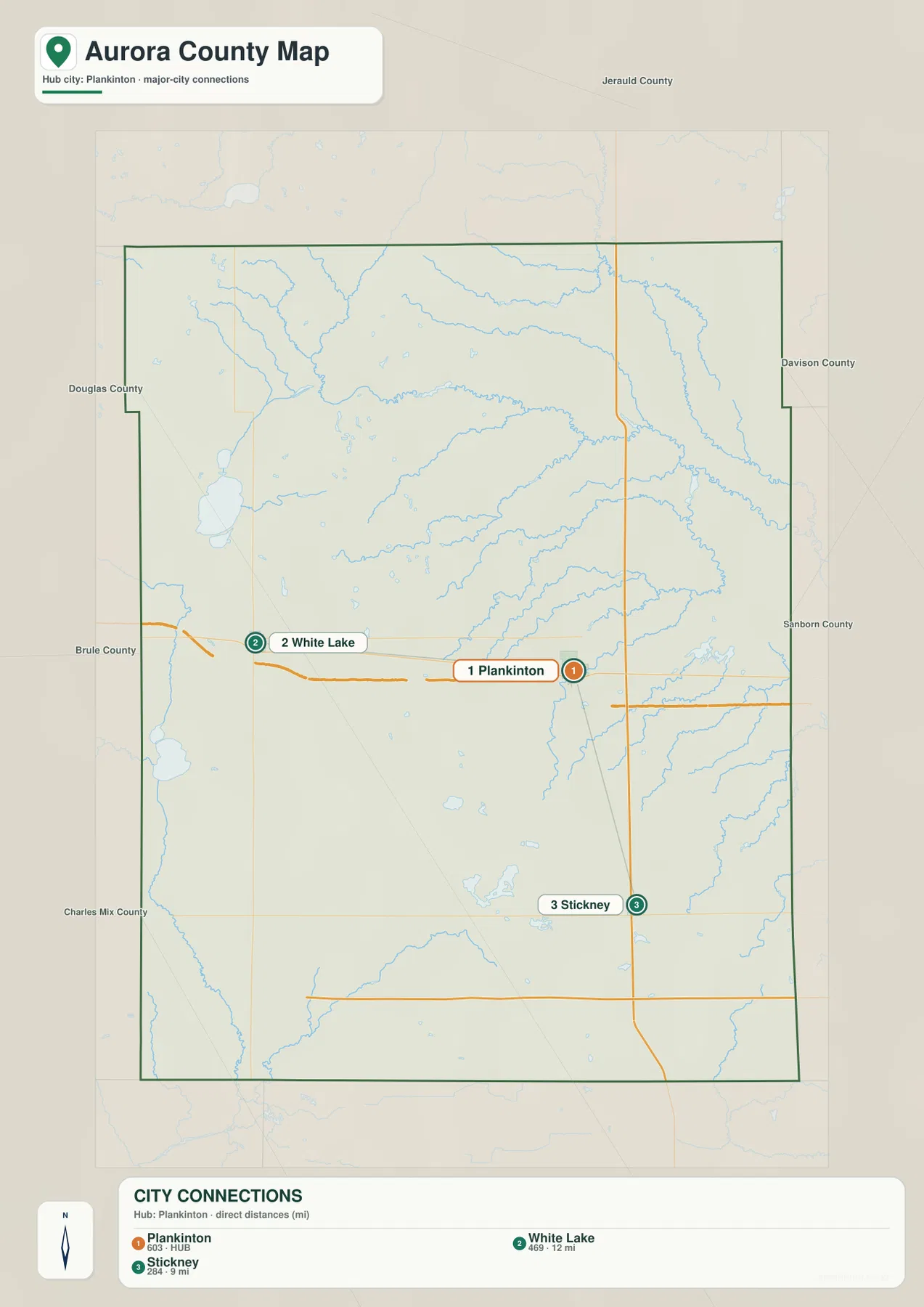
The surrounding-county labels reinforce the same pattern. White Lake sits close to the western side facing Brule County, whereas Stickney occupies the southeastern part of Aurora County closer to the Davison and Charles Mix directions. Plankinton is positioned between them and functions as the most practical map anchor for moving from the county-wide outline to specific road and water features.
Firesteel Creek organizes the north while Platte Creek defines the southwest edge
The terrain-and-water map is dominated by the northern drainage. West Branch Firesteel Creek appears in the northwest, and Wilmarth Lake sits along the same broad northern zone. Firesteel Creek continues across the north and northeast, with Stoddard Lake labeled farther east. A dense set of smaller tributaries branches around these features, making the upper half of Aurora County look very different from the simpler road map.
The west and south carry a separate set of water references. White Lake is a prominent body of water near the western side, with Isham Lake farther north. Platte Lake and Platte Creek appear toward the southwest, and East Fork Platte Creek is labeled along the southern edge. Crystal Lake sits farther into the south-central interior, while Fish Lake and Emery Creek provide useful references on the eastern side.
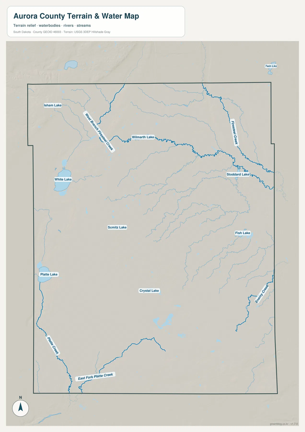
This water map is useful for locating drainage features, not for judging flood risk, water depth, navigability, parcel access, or legal boundaries. A branching creek network can look prominent on a reference map without saying anything about current water levels or hazards. Those questions require dedicated, current official data.
Elevation rises most clearly in the northwest and drops along northeastern drainages
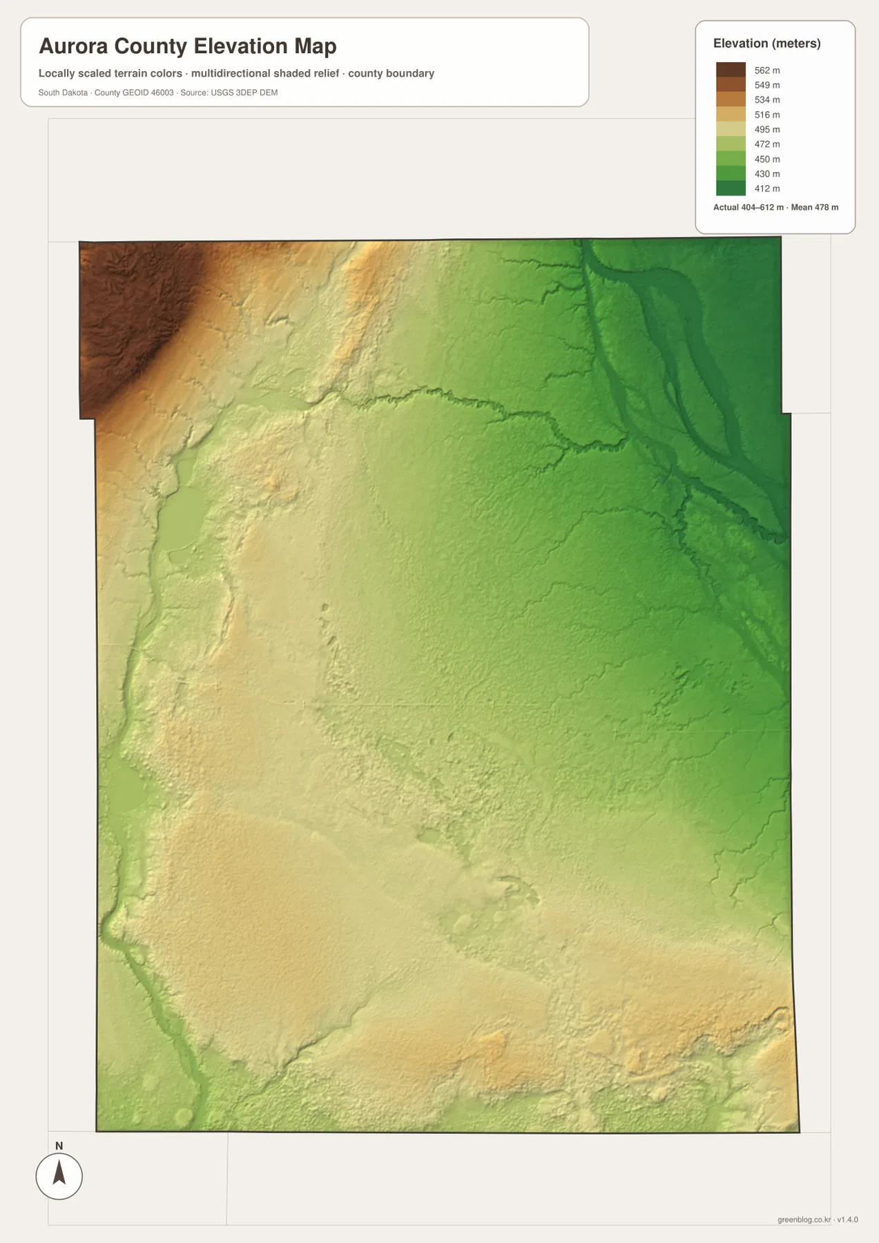
The separate elevation map reports an actual county range of roughly 404 to 612 meters, with a mean near 478 meters. The strongest high-to-low contrast is visible across the northern part of the county. Brown and tan colors mark higher ground in the northwest, while dark green spreads through the northeast where the drainage lines become more pronounced.
Most of the central and southern county is less dramatic. Broad areas of yellow-green and green show gradual changes rather than steep mountain relief, although the southeast and southern margins still contain local rises and shallow valleys. The hillshade helps small drainage cuts stand out, but the color surface is a generalized county-scale elevation reference and should not be used as a survey or engineering measurement for a specific property or road.
Move from a route question to water and relief without crowding one map
If the first question is where Plankinton, White Lake, or Stickney lies, the road map is the most useful starting point because I-90 and US 281 provide immediate orientation. The city map is better when the only goal is to compare direction and straight-line separation. Once a location is established, the water map can show whether the nearby landscape is part of the Firesteel Creek network, the Platte Creek side, or one of the smaller lake areas.
The elevation map adds one more layer without repeating the same information. Around northern Aurora County, it explains why the drainage-heavy northeast looks lower than the high northwest. In the south, it shows a gentler surface where roads and streams cross broad prairie terrain. Switching among the maps therefore works better than expecting one image to carry roads, settlements, hydrography, and elevation at the same level of detail.
The WebP images in the article are lightweight previews for browser viewing. Use the JPG originals from the ZIP when you need a larger print or document layout. For live road conditions, flood information, parcel boundaries, or exact spot elevations, check the appropriate current official source in addition to these reference maps.
Frequently Asked Questions
Are the 12-mile and 9-mile city distances driving distances?
No. The city map shows straight-line distances from Plankinton: about 12 miles to White Lake and about 9 miles to Stickney. Driving mileage can be longer because vehicles must follow I-90, US 281, or the local road network.
Which map shows Firesteel Creek and the Platte Creek drainage most clearly?
Use the terrain-and-water map. Firesteel Creek and West Branch Firesteel Creek are labeled across the northern part of Aurora County, while Platte Creek and East Fork Platte Creek appear toward the southwest and south. White Lake, Wilmarth Lake, and Stoddard Lake are also labeled there.
What does the Aurora County elevation map show?
It shows a countywide elevation range of about 404 to 612 meters and a mean near 478 meters. The northwest is the most obvious higher area, while lower green terrain is concentrated in the northeast around major drainage lines. It is a county-scale reference rather than survey-grade elevation data.
Map File Information
Download the Aurora County road map, city-connection map, terrain-and-water map, and elevation map together as high-resolution A3 JPG files.
- Included Files: 4 JPG maps
Related Maps
Sources and Reference Data
- U.S. Census Bureau TIGER/Line Shapefiles: county boundaries, roads, and geographic reference data
- USGS National Hydrography: streams, creeks, lakes, and hydrographic reference data
- USGS 3D Elevation Program: elevation and shaded-relief reference data
- South Dakota Unified Judicial System – Aurora County: official Aurora County courthouse and Plankinton location reference
Green Map creates custom-edited map images using open geographic data sources such as geoBoundaries, Natural Earth, OpenStreetMap, and government open data.
These maps are edited visual materials, not raw data files, and are provided for education, documents, presentations, and graphic reference.