Matanuska-Susitna Borough combines a concentrated southern settlement area with a much larger interior that stretches north and west across river valleys and mountain terrain. On the supplied county map, Wasilla and Palmer sit near the southern edge, with Houston, Big Lake, Point MacKenzie, Willow, and Susitna nearby or farther northwest. Susitna North, Trapper Creek, Petersville, and Chase continue northward, while Skwentna lies well to the west and Glacier View and Eureka Roadhouse sit on the eastern side. This article follows only features visible in the supplied maps and supporting package, and the matching high-resolution JPG map files can be downloaded together in the ZIP box below.
The borough is easier to understand when the southern city cluster and the broad northern drainage country are viewed as parts of the same map rather than as separate subjects. Route 3 runs north through the central part of the county map, Route 1 appears across the southeast and east, and Route 8 is marked near the northern edge. The terrain-and-water map shifts attention from roads to the Susitna River system, including the Little Susitna, Talkeetna, Kahiltna, Talachulitna, Sheep, Oshetna, and Knik rivers. Moving from the general map to the city-connections map and then to the water map makes the scale of the borough much clearer.
Table of Contents
The southern city cluster gives way to a long interior corridor toward Trapper Creek
The county map is the best place to begin because it shows communities, numbered routes, waterways, and the full borough boundary together. Wasilla and Palmer are close to the southern edge, with Houston and Big Lake to the west and northwest. Point MacKenzie appears farther southwest, Susitna lies beyond it, and Willow is farther north along the main north-south route. The concentration of labels in this southern area is noticeably different from the broad interior where towns are more widely separated.
Following Route 3 north brings Susitna North and then Trapper Creek into view. Petersville lies to the west of that corridor, while Chase is positioned to the east. Farther west, Skwentna is separated from the Wasilla-Palmer cluster by a large area filled with rivers and smaller water features. On the east side, Glacier View and Eureka Roadhouse line up with the Route 1 direction. These placements make the borough look less like a single metropolitan district and more like several settlement areas connected across a very large landscape.
The numbered roads are useful orientation lines, but the map is not a live transportation product. It does not show current road conditions, travel times, closures, or every local road. Its strongest use is geographic: locating Wasilla and Palmer, following the main route north toward Willow and Trapper Creek, comparing the eastern and western edges, and seeing how much land remains inside the borough beyond the denser southern settlements.
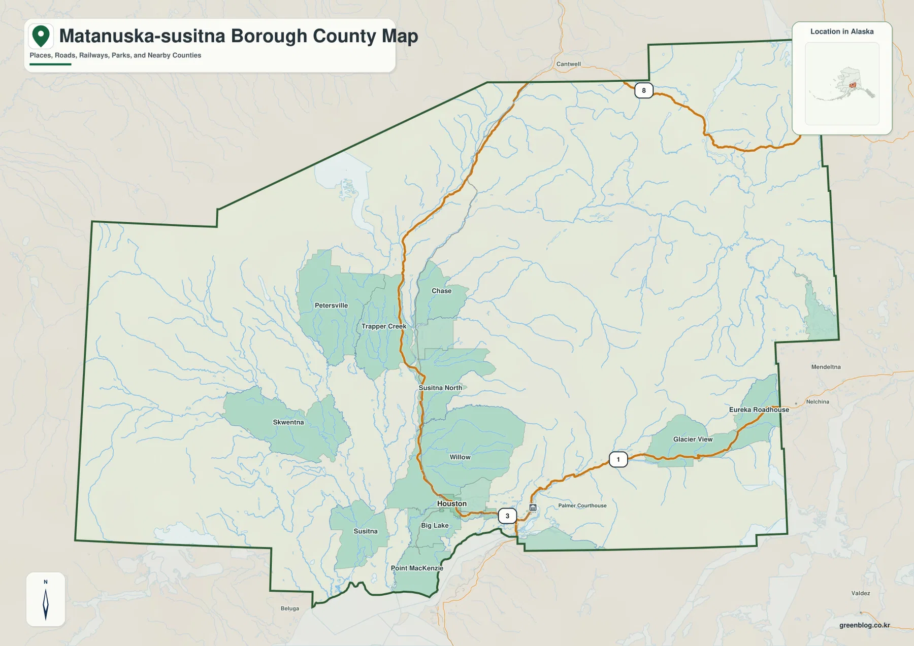
Labels outside the boundary, including Cantwell to the north and Mendeltna, Nelchina, Beluga, and Valdez around the edges, provide useful regional orientation. They help show where the borough sits relative to surrounding Alaska locations, but they should not be treated as a replacement for an official legal boundary dataset. When exact coordinates, parcel questions, or formal jurisdictional boundaries matter, Census TIGER/Line data or the relevant borough and state records are more appropriate.
Wasilla acts as the city-map hub for Palmer and Houston
The city-connections map removes most of the smaller place labels and focuses on three communities: Wasilla, Palmer, and Houston. Wasilla is marked as the hub. The panel lists Palmer at 12 mi and Houston at 11 mi from the hub, and the map uses direct connector lines rather than a road-routing network. Those distances should therefore be read as straight-line map distances, not driving mileage or travel time.
Wasilla appears near the center of the southern cluster, Palmer lies to the east, and Houston is northwest of Wasilla. This simplified arrangement is useful when a full county map contains more detail than a presentation or classroom explanation needs. It quickly answers a basic location question: the three highlighted cities occupy the southern part of a borough that extends far beyond them to the north, west, and east.
The printed CITY CONNECTIONS panel also shows map-index values of 9,720 for Wasilla, 6,268 for Palmer, and 1,834 for Houston. These are values printed on the supplied map and are useful for understanding how the map ranks or summarizes the three places. They should not be presented as the latest official population counts without checking the current Census release. For this page, the strongest information in the city map is the relative placement of the three communities and the direct-distance labels.
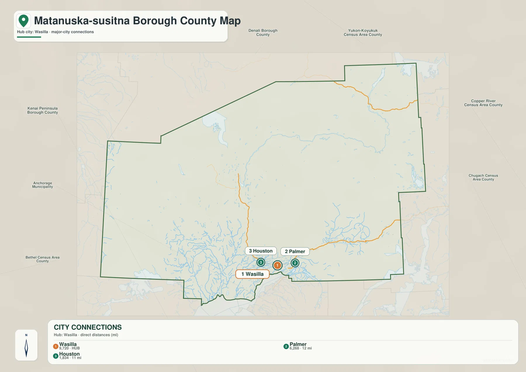
Names outside the borough include Denali Borough, Yukon-Koyukuk Census Area, Copper River Census Area, Chugach Census Area, Anchorage Municipality, Kenai Peninsula Borough, and Bethel Census Area. Their placement helps frame Matanuska-Susitna Borough within a much larger part of Alaska. The map is intended for regional orientation, however, not for survey-grade measurement or the legal interpretation of neighboring boundaries.
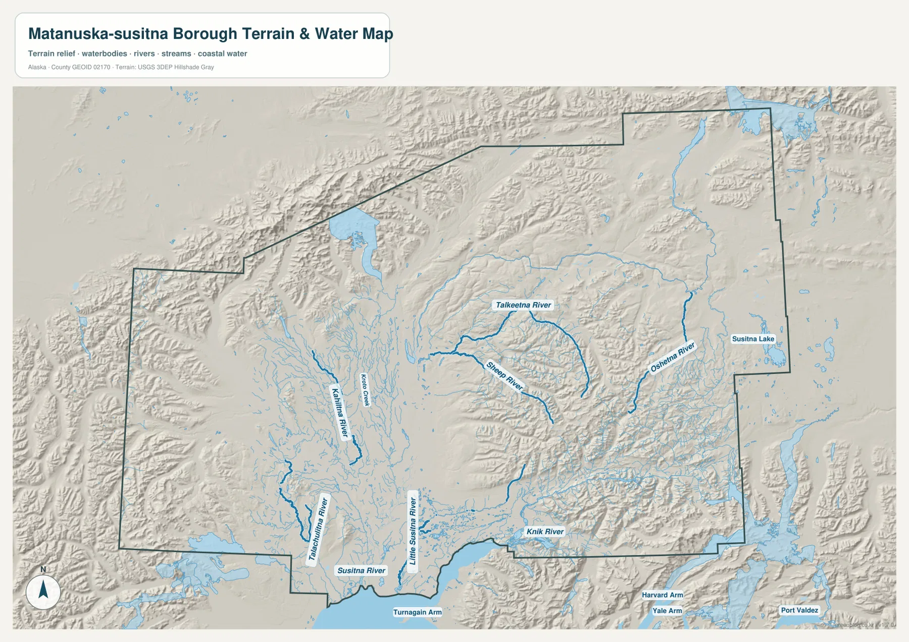
The Susitna River system organizes much of the central and northern landscape
The terrain-and-water map reveals detail that is easy to miss on the general map. The Susitna River is one of the clearest named water features in the southern-central part of the borough. The Little Susitna River appears to its east, while the Talachulitna River and Kahiltna River are labeled farther west. Kroto Creek is shown in the central interior. Together, these waterways make the wide central area look very different from the compact Wasilla-Palmer city cluster seen on the city map.
Farther north and east, the Talkeetna River curves across the map, with the Sheep River to the south and the Oshetna River farther east. Susitna Lake is labeled near the eastern side. Shaded relief becomes more pronounced in the north and east, where ridges and valleys are easier to see than in some of the broad southern and western lowlands. The map does not provide surveyed elevation values, but the relief shading is useful for comparing the general ruggedness of different parts of the borough.
Near the southeast boundary, the Knik River runs toward Turnagain Arm. Seeing Knik River, the lower Susitna system, and the northern mountain rivers on the same map shows that the borough’s waterways do not form one simple line. Different drainage areas point toward different parts of the surrounding landscape. This map is a geographic reference, not a flood-risk map, hydrographic navigation chart, parcel map, or legal water-boundary product.
The maps show a sharp contrast between the south and the broad interior
Viewed together, the three maps show a strong geographic contrast. The south contains the clearest cluster of communities and road labels, especially around Wasilla, Palmer, Houston, and Big Lake. North of Willow and Susitna North, community labels become farther apart. Petersville, Trapper Creek, Chase, and the wide northern boundary sit within a landscape where rivers, valleys, and relief occupy much more of the visual space than urban labels do.
The west has a similar sense of scale. Skwentna and Susitna are well separated from the southern hub, and the water map fills the intervening area with numerous channels and tributaries. The eastern edge is different again, with Glacier View and Eureka Roadhouse associated with the Route 1 direction and more strongly shaded terrain nearby. None of these patterns by itself explains settlement history or transportation access, but they are useful visible facts when comparing where communities, roads, rivers, and terrain occur within the borough.
Choose the map that matches the question you are trying to answer
The county map is the best choice when you need the full borough boundary, the larger set of community labels, and the main numbered routes in one view. For a simple comparison of Wasilla, Palmer, and Houston, the city-connections map removes the extra labels. Rivers, lakes, valleys, and broad relief are easiest to compare on the terrain-and-water map. Moving among the three versions is more useful than expecting one map to answer every kind of question.
The downloadable ZIP contains the larger original JPG versions corresponding to the three maps used in the article. They are useful for printing, offline study, presentations, and local-reference material when a larger image is preferable to the WebP displayed in the page. High resolution does not make the maps legal, survey-grade, engineering-grade, or suitable for flood or navigation decisions; official data should be used when precision has legal or safety consequences.
Frequently Asked Questions
How should the 12-mile and 11-mile city connections be interpreted?
The city map uses Wasilla as the hub and labels Palmer at 12 mi and Houston at 11 mi. These are straight-line connector distances on the supplied map, not road mileage or estimated driving time. For an actual trip, a current routing or road-information source is more appropriate.
Which map is best for following the Susitna River and its tributaries?
The terrain-and-water map is the best choice because it labels the Susitna River together with the Little Susitna, Talkeetna, Kahiltna, Talachulitna, Sheep, Oshetna, and Knik rivers. It also includes relief shading, making it easier to compare broad valleys and more rugged terrain. The county map is better when you need to relate those waterways back to settlements and major roads.
What files are included in the download ZIP?
The ZIP contains three high-resolution JPG files matching the article’s county map, city-connections map, and terrain-and-water map. They are suitable for general printing, presentation, education, and geographic reference, but they are not legal boundary surveys, flood maps, navigation charts, or engineering plans.
Map File Information
Download the Matanuska-Susitna Borough maps as high-resolution JPG files. The ZIP contains the county map, city-connections map, and terrain-and-water map shown in this article.
- Included Files: Use only the versions confirmed in the article and supplied images
- File Type: Use the confirmed download contents
- Intended Use: Printing, education, presentations, and map-based projects
Related Maps
Sources and references
For local road and mapping information, see the Matanuska-Susitna Borough Road Service Area Maps and the borough’s official government overview. Official administrative boundary data are available from the U.S. Census Bureau TIGER/Line Shapefiles. Water-network reference data are available through USGS National Hydrography, and detailed elevation data are available from the USGS 3D Elevation Program.
Green Map creates custom-edited map images using open geographic data sources such as geoBoundaries, Natural Earth, OpenStreetMap, and government open data.
These maps are edited visual materials, not raw data files, and are provided for education, documents, presentations, and graphic reference.