Chugach Census Area is a south-central Alaska region where long mountain coasts, islands, major rivers, and separated communities surround Prince William Sound. The supplied Chugach Census Area Map labels Valdez, Cordova, Whittier, Tatitlek, and Chenega, and it also shows numbered road corridors 4 and 10. A separate city-connections sheet uses Valdez as its hub, while the terrain-and-water map names Prince William Sound, the Copper River, Copper River Delta, and the Gulf of Alaska. High-resolution JPG versions of the three supplied map subjects are available in the ZIP download near the end of this page.
The area is not organized like a compact inland county with one continuous road network. Valdez sits on a northern inlet, Cordova lies along the southeastern side, and Whittier appears near the western edge. Tatitlek is positioned among the intricate islands and shoreline south of Valdez, while Chenega is much farther southwest. Water separates many of the major reference points, and the shoreline repeatedly bends around islands, bays, and peninsulas. For a first reading, it helps to locate Prince William Sound and the three main city markers before following smaller roads or streams.
Table of Contents
Valdez, Cordova, and Whittier occupy different sides of a deeply indented coast
On the general map, Valdez is easy to find along the northern side of Prince William Sound. An orange road line continues east from the Valdez area and connects with the corridor marked by a route shield labeled 4. Cordova appears well to the southeast, where another orange road segment curves around the city and a route shield labeled 10 is visible. The two communities do not form one continuous urban corridor on the map. A broad expanse of coastal water and mountain terrain lies between them, which is why their positions are better understood by using the shoreline as well as the road symbols.
Whittier is labeled near the far western side of the outlined census area. Tatitlek appears south of Valdez amid a complicated section of islands and coastal land, while Chenega is farther southwest. These locations show how widely the named communities are spread across the map. The dark green boundary follows a highly irregular mix of mainland coast, islands, and narrow projections rather than a simple rectangular county shape. Keeping the boundary line and water areas in view makes it easier to tell where one part of the census area ends and another coastal section begins.
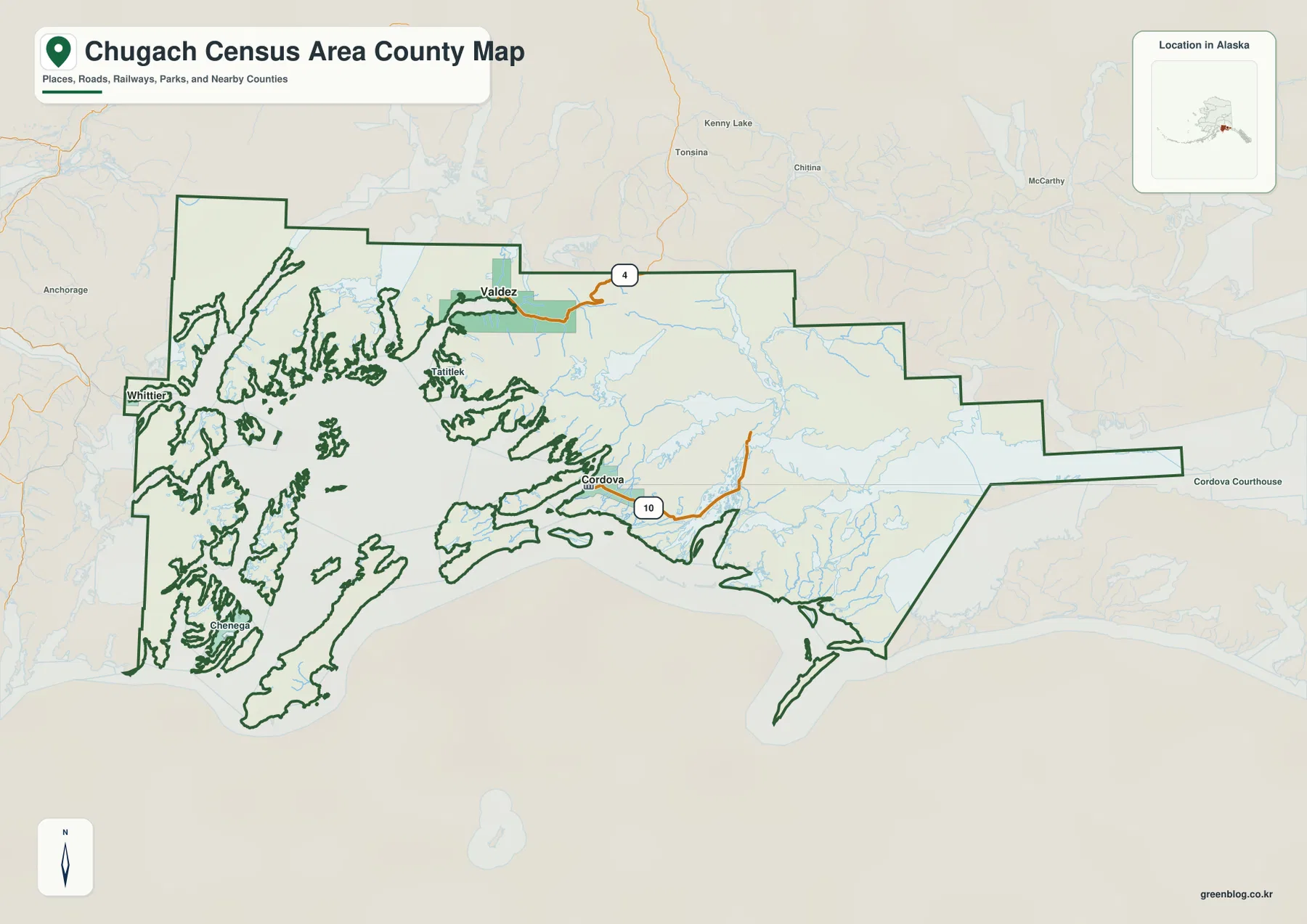
Labels outside the target boundary provide useful orientation. Kenny Lake, Tonsina, and Chitina appear north of the census area, McCarthy is farther east, and Anchorage is visible to the west on the basemap. These names should not be treated as a list of places inside Chugach Census Area. They are surrounding reference points that help place the outlined region within a broader part of Alaska. When an exact inside-versus-outside distinction matters, the dark green census-area boundary is the most reliable visual guide on the supplied map.
The city-connections sheet uses Valdez as a hub for two widely separated coastal cities
The city-connections map highlights three selected places. Its CITY CONNECTIONS panel prints Valdez 3,847, Cordova 2,453, and Whittier 411. Those values are reported here exactly as they appear on the supplied sheet; they are not replaced with a separate current population estimate. Valdez is marked as the HUB. The same panel prints direct-distance values of 47 mi for Cordova and 80 mi for Whittier. Because the map explicitly labels these as direct distances, they should not be interpreted as driving mileage or scheduled travel distance.
The marker arrangement gives the numbers useful context. Valdez is in the north, Cordova lies to the southeast, and Whittier sits far to the west. Prince William Sound, islands, and steep coastal terrain occupy much of the area between them. A straight-line figure therefore says little about the real transportation options available at a given time. The purpose of this sheet is better understood as geographic comparison: it quickly shows the direction and broad spacing of the three selected cities within the same county-equivalent boundary.
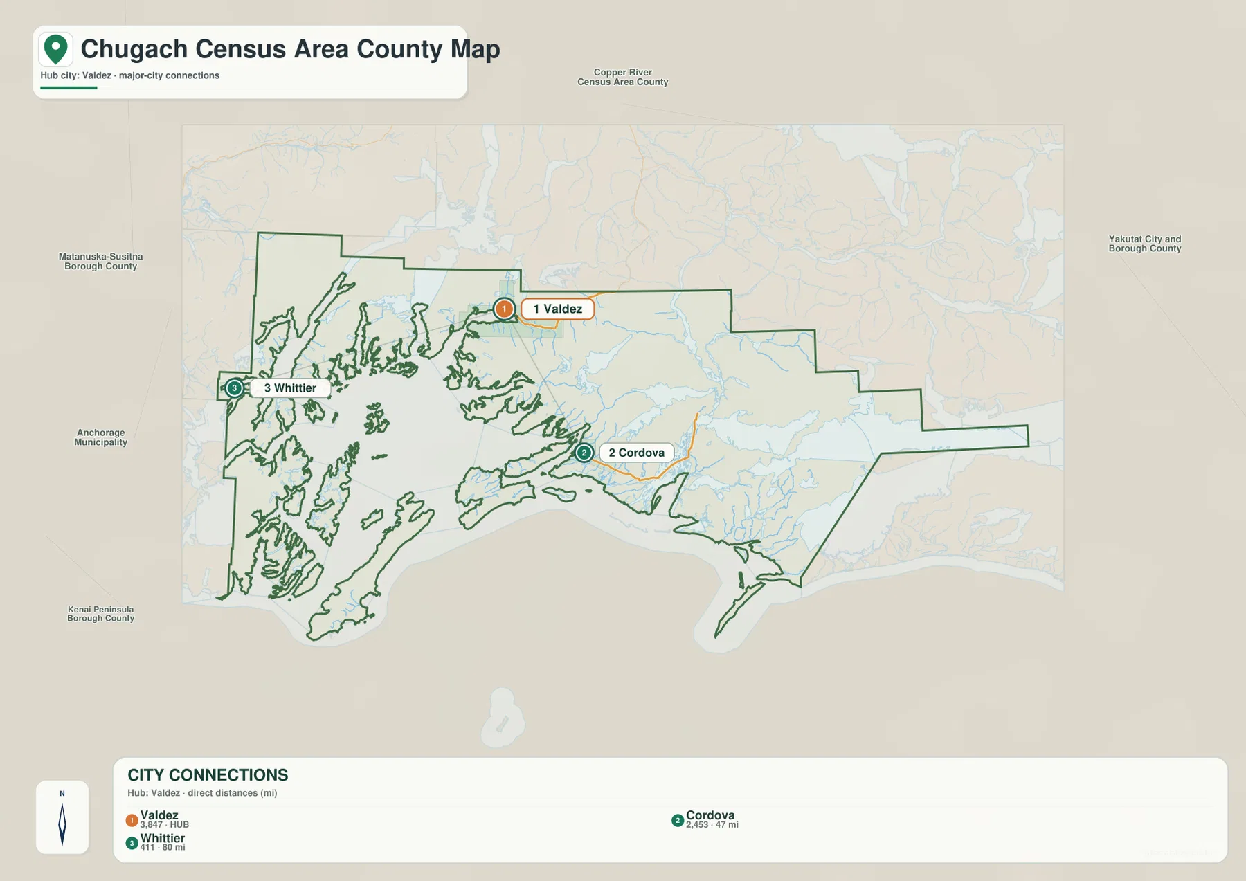
Neighboring administrative names are also printed around the city map. Copper River Census Area appears to the north, Yakutat City and Borough to the east, Anchorage Municipality to the west, and Kenai Peninsula Borough to the southwest. These surrounding labels help place Chugach Census Area in south-central Alaska without adding them to the target area’s city list. The map is useful for broad orientation, but a legal boundary, parcel, or jurisdictional decision should still be checked against current official administrative data.
Prince William Sound dominates the water map while the Copper River opens into a broad delta
The terrain-and-water sheet makes the region’s coastal geography much clearer. Prince William Sound occupies a large central and southwestern part of the map, surrounded by steep land, islands, and narrow channels. Turnagain Arm is labeled at the western side, while the Gulf of Alaska appears beyond the southeastern coast. With those three water names in view, the reader can see that Chugach Census Area reaches across more than one kind of coast. The interior shore of Prince William Sound looks very different from the open Gulf of Alaska edge farther east.
On the eastern side, the Copper River becomes the strongest river reference. The map follows it through a broad river corridor near Miles Lake and toward the Copper River Delta along the coast. Other named waterways include Lowe River, Rude River, Wernicke River, Bering River, and Seal River. Smaller streams are also visible against the shaded terrain. Starting with the Copper River and then moving outward to these secondary names is an easier way to use the map than trying to identify every blue line at once.
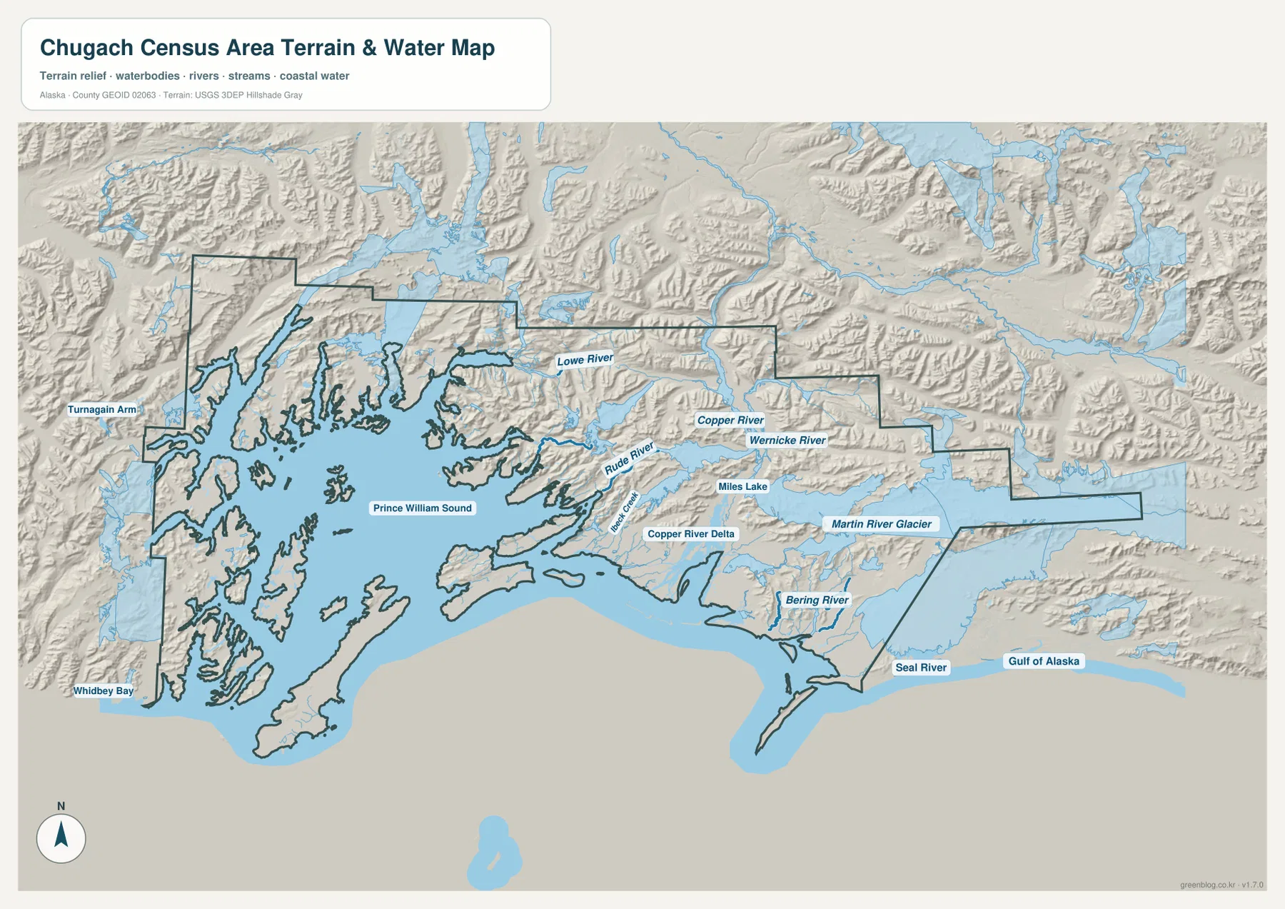
Martin River Glacier is also labeled east of the delta area. The shaded relief shows extensive ridges and valleys across much of the census area, while the Copper River Delta has a broader, lower-looking coastal form. The islands and peninsulas around Prince William Sound are also shown as rugged rather than flat. This relief is useful for understanding the relationship between mountains, rivers, and shoreline, but it is not a contour map for measuring exact elevations. Anyone who needs numeric elevation values should use a dedicated elevation dataset.
The water sheet is equally unsuitable for navigation or hazard decisions. It does not provide water depth, navigation aids, currents, tides, real-time weather, or glacier hazards. Its role is to show named water features and the broad terrain around them. Marine travel, flood assessment, or emergency planning requires current authoritative information from the appropriate agencies. For additional hydrographic reference, the USGS National Hydrography source linked below provides an official data framework.
Using Valdez as the first landmark simplifies a complicated map
A practical way to learn the map is to begin at Valdez. It has a clear label on the northern shore and a visible road connection toward route 4. From there, look south and southwest across Prince William Sound to find the island-rich coast around Tatitlek and the western direction toward Whittier. Shift southeast and Cordova appears with the route 10 marker nearby. Once those three directions are established, smaller place labels and waterways become much easier to place within the overall outline.
The next step is to open the terrain-and-water map and revisit the same positions. Prince William Sound lies immediately south of the Valdez area. Moving toward Cordova brings the reader closer to the Copper River and the broad delta on the eastern coast. Looking toward Whittier shifts attention to the western side of the sound and the direction of Turnagain Arm. Matching city locations to these large water features reduces the confusion created by the many islands and irregular shorelines.
Places such as Chenega and Tatitlek are not the main focus of the three-marker city-connections sheet, so the general map is better for locating them. Once found, the terrain-and-water map provides the surrounding coastal setting. The reverse is true if the only question is how Valdez, Cordova, and Whittier are positioned relative to one another: the city sheet removes many smaller labels and makes that comparison faster. The maps work best when each is used for the question it was designed to answer.
Choose the sheet by task, then use the high-resolution files for print or offline reference
Only the three map subjects supplied in this package are described on this page. The general sheet is best for the full boundary, place names, and the visible road corridors. The city-connections sheet is a cleaner view of Valdez, Cordova, and Whittier and the direct-distance values printed with them. The terrain-and-water sheet provides the strongest view of Prince William Sound, the Copper River, coastal drainage, and mountain relief. Selecting the sheet that matches the task is more useful than expecting one image to carry every kind of information.
- Boundary, places, and roads: start with the general map for Valdez, Cordova, Whittier, Tatitlek, Chenega, and route shields 4 and 10.
- Selected city comparison: use the city-connections sheet for the three main markers and the direct-distance figures shown from the Valdez hub.
- Water and terrain: use the terrain-and-water map for Prince William Sound, the Copper River, Copper River Delta, the Gulf of Alaska, named rivers, and shaded mountain relief.
For a classroom or presentation, one useful sequence is to begin with the general map, move to the city-connections sheet to show how far apart the selected communities are, and finish with the terrain-and-water map to explain the coastline and river system. The downloadable ZIP contains larger JPG versions for situations where the screen-sized WebP images are not enough. These maps remain general reference products, so surveying, navigation, emergency planning, and other high-precision uses should rely on current official sources.
Frequently Asked Questions
Which map is best for comparing Valdez, Cordova, and Whittier?
The city-connections map is the simplest choice for that comparison. It marks Valdez as the hub and gives Cordova and Whittier their own numbered markers. The panel also prints direct-distance values from the Valdez hub. If you also need Tatitlek, Chenega, roads, or more coastline detail, use the general map alongside it.
Where can I see Prince William Sound and the Copper River most clearly?
The terrain-and-water map gives them the clearest labels and context. Prince William Sound fills much of the central and southwestern coastal area, while the Copper River runs through the eastern side toward the Copper River Delta. The same sheet also labels Miles Lake, Lowe River, Wernicke River, Bering River, Martin River Glacier, and the Gulf of Alaska.
What is included in the downloadable ZIP?
The ZIP contains three high-resolution JPG files matching the subjects shown on this page: the general county-equivalent map, the city-connections map, and the terrain-and-water map. It does not include a separate elevation-only sheet or a marine navigation chart. Use the JPG files when a larger image is needed for print or offline work.
Sources and reference data
This article is based on the boundary, place labels, road symbols, city-connections panel, waterways, and terrain shown in the supplied Chugach Census Area maps. The federal links below provide official reference frameworks for administrative boundaries, hydrography, and elevation data.
Map File Information
Chugach Census Area Map Files
- Included Files: 3 high-resolution JPG images
- File Type: JPG files in one ZIP archive
Related Maps
Green Map creates custom-edited map images using open geographic data sources such as geoBoundaries, Natural Earth, OpenStreetMap, and government open data.
These maps are edited visual materials, not raw data files, and are provided for education, documents, presentations, and graphic reference.