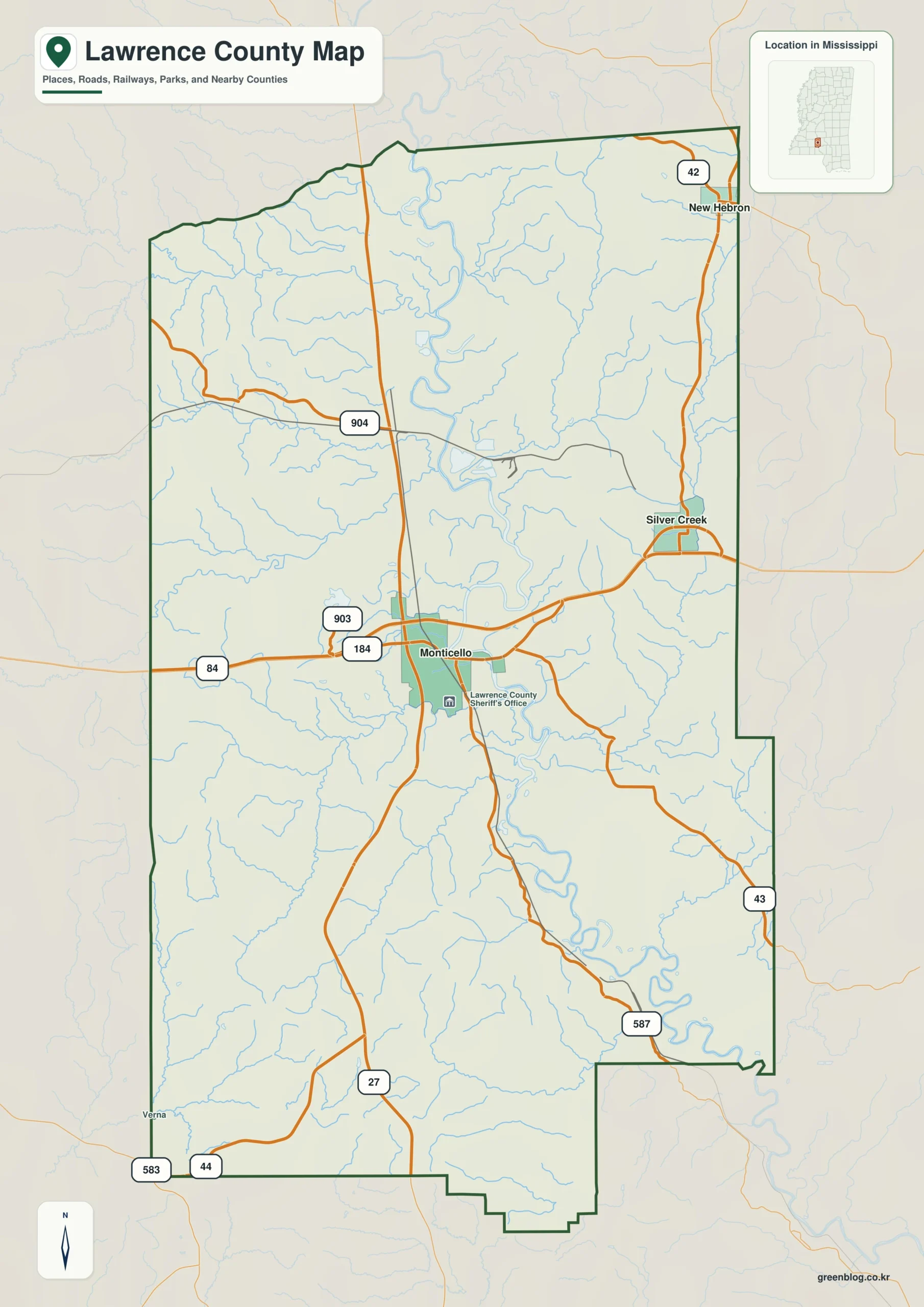
The Lawrence County Mississippi map centers on Monticello beside the Pearl River, then places New Hebron to the north, Silver Creek to the east, and Sontag in the southwest. The US 84 and MS 27 area forms an administrative and transport center between river bottomland and wooded uplands.
Lawrence County Mississippi map download
The WebP preview is optimized for the page, while the button preserves the original high-resolution JPG for printing and reuse.
- File: County reference map
- Format: JPG
- Print layout: A3
Quick Facts
- State and identifier: Mississippi, Lawrence County; FIPS 28077
- County seat: Monticello
- Selected map labels: Monticello, New Hebron, Silver Creek, Sontag
- 2020 census population: 12,016
- July 2025 population estimate: 11,819
- 2025 Gazetteer area: 430.602 sq mi land and 5.092 sq mi water
- 2020 land-area density: 27.9 residents per sq mi
- Primary route references: US 84, MS 27, MS 43, and MS 44
- Landscape references: Pearl River, Strong River tributaries, wooded rolling uplands, and river bottoms
The decennial count and July 2025 estimate use different reference dates. Land and water measurements come from the 2025 Gazetteer. The density of 27.9 residents per square mile divides the 2020 population by 2025 land area and does not imply an even distribution among cities, farms, forest, or wetland.
Reading the Lawrence County Mississippi map
US 84 leads east from Monticello toward Silver Creek and Jefferson Davis County, and west toward Lincoln County. MS 43 provides the northern approach toward New Hebron, while MS 27 continues southwest toward Walthall County; Sontag adds a rural southwestern reference. Minor forest roads and small tributaries are selectively omitted.
Boundary, Water, and Terrain
The Pearl River flows south near Monticello and creates the county's broadest bottomland corridor. Rolling pine-covered ground continues toward Simpson County in the northeast and Jefferson Davis and Marion counties in the east. Streams from the Lincoln and Franklin county sides also join the Pearl system, giving the map a clear central drainage direction.
Settlement and Regional Context
Monticello concentrates courthouse, school, retail, and river-crossing functions. New Hebron and Silver Creek provide smaller service references for the northern and eastern county, while Sontag represents the rural southwest. Forestry and agriculture explain much of the land use outside the towns, where settlement follows highways and higher ground near stream valleys.
Practical Map Uses
- Relate Monticello's US 84 crossing to the Pearl River
- Use New Hebron and Silver Creek for northern and eastern orientation
- Place Sontag between the Lincoln and Walthall county approaches
Frequently Asked Questions
Why is Monticello closely associated with the Pearl River?
The town lies near an important highway crossing of the river. Reading US 84 and the river together explains its central transport and administrative position.
How can Pearl River clarify the part of Lawrence County facing Copiah?
Looking only at Monticello would reduce the map to town labels, whereas Pearl River explains the landscape transition toward Copiah.
Sources
- U.S. Census Bureau QuickFacts
- U.S. Census Bureau 2025 Gazetteer Files
- Mississippi Department of Transportation official highway map
- Regional landscape or institution reference
Related County Maps
Green Map creates custom-edited map images using open geographic data sources such as geoBoundaries, Natural Earth, OpenStreetMap, and government open data.
These maps are edited visual materials, not raw data files, and are provided for education, documents, presentations, and graphic reference.