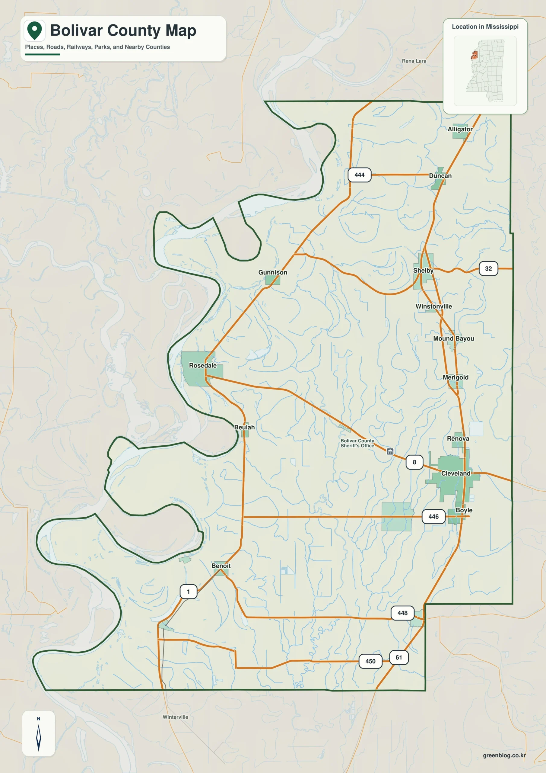
The Bolivar County Mississippi map has two administrative anchors—Cleveland and Rosedale—set within the broad Delta floodplain. Mound Bayou, Shelby, Shaw, and Benoit extend the view along Highway 61 and the river-side corridor, revealing a long county rather than a single-center district.
Bolivar County Mississippi map download
The WebP preview is optimized for the page, while the button preserves the original high-resolution JPG for printing and reuse.
- File: County reference map
- Format: JPG
- Print layout: A3
Quick Facts
- State and identifier: Mississippi, Bolivar County; FIPS 28011
- County seat: Cleveland and Rosedale
- Selected map labels: Cleveland, Rosedale, Mound Bayou, Shelby, Shaw, Benoit
- 2020 census population: 30,985
- July 2025 population estimate: 28,262
- 2025 Gazetteer area: 876.507 sq mi land and 31.447 sq mi water
- 2020 land-area density: 35.4 residents per sq mi
- Primary route references: US 61, US 278, MS 1, MS 8, and MS 32
- Landscape references: Mississippi River, Delta floodplain, levees, and agricultural drainage networks
The decennial count and the July 2025 estimate represent different reference dates. Land and water values come from the 2025 Gazetteer. The density of 35.4 residents per square mile uses the 2020 population and land area; it does not imply an even distribution among towns, farms, forests, or floodplain.
Bolivar County Mississippi map: What It Shows
Cleveland anchors the eastern interior; Rosedale sits closer to the Mississippi River and levee system. MS 1 traces the river side, whereas US 61 links inland Delta communities. Mound Bayou and Shelby orient the north, Shaw the southeast, and Benoit the southwestern portion of the county.
County Layout and Location
Bolivar stretches across 876.5 square miles of land, making north–south distance a defining feature. Levees, drainage channels, and cultivated fields dominate the flat terrain between the river and the eastern county line. The reference map simplifies that dense local network to maintain legibility.
Local Context: Two Seats and Delta Plain
Delta agriculture, Highway 61 music history, and the Mississippi River all shaped Bolivar’s geography. Mound Bayou emerged in 1887 as a major African American self-governed community, while Delta State University strengthened Cleveland’s role. These places give the map several meaningful centers rather than one dominant seat.
Ways to Use This Map
- Explain why Bolivar County operates with two county seats
- Compare the river-side MS 1 corridor with inland US 61
- Place Mound Bayou and Cleveland within a Delta history project
Frequently Asked Questions
How should the two Bolivar County seats be read on the map?
Cleveland represents the eastern interior, while Rosedale provides a river-side administrative anchor. The distance between them reflects the county’s unusual length and dual-seat arrangement.
Why compare Mississippi River with the spacing from Cleveland to Rosedale and Coahoma?
The interval from Cleveland to Rosedale describes settlement spacing, while Mississippi River and the Coahoma side add physical and boundary evidence.
Sources
- U.S. Census Bureau QuickFacts
- U.S. Census Bureau Gazetteer Files
- Mississippi Encyclopedia: Bolivar County
- Mississippi Department of Transportation official highway map
Related County Maps
Green Map creates custom-edited map images using open geographic data sources such as geoBoundaries, Natural Earth, OpenStreetMap, and government open data.
These maps are edited visual materials, not raw data files, and are provided for education, documents, presentations, and graphic reference.