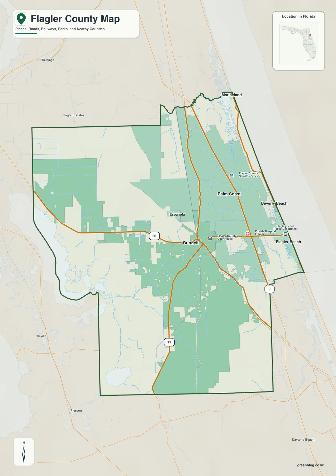
The Flagler County Map makes more sense once three different parts of the county are separated in your mind. Bunnell is the county seat and the main inland road reference, Palm Coast contains the largest concentration of neighborhoods and canals, and Flagler Beach marks the Atlantic end of SR 100. Download the high-resolution A3 JPG map ZIP from the file box below when you need the full-size files; it contains the county, city, and water maps used on this page. North of Flagler Beach, Beverly Beach and Marineland continue along the A1A corridor, while the western side of the county becomes much quieter around Haw Creek, wetlands, timberland, and the Lake Disston area.
Table of Contents
SR 100 Links Bunnell, I-95, and Flagler Beach in One Easy Line
If you need one road to orient yourself, start with SR 100. It passes through Bunnell, crosses the US 1 corridor, reaches I-95, continues over the Intracoastal Waterway, and ends at A1A in Flagler Beach. That sequence ties together the county seat, the interstate, Palm Coast’s southern side, and the oceanfront without forcing you to learn every local street first.
The general map also places Palm Coast, Beverly Beach, Marineland, and Espanola around that east-west framework. Road and settlement labels become much denser toward the Atlantic, while the interior and southwest show larger stretches with fewer built-up features. The difference reflects the county’s real settlement pattern rather than missing map data: most residents live in the eastern municipalities, while timber, agriculture, wetlands, and conservation lands occupy much more of the interior.
Census figures in the supplied material give Flagler County 115,378 residents in 2020 and an estimated 140,360 on July 1, 2025. The same material lists 486.20 square miles of land and a 2020 density of 237.3 people per square mile. County information notes that the five incorporated municipalities occupy about 48 percent of the land but contain roughly 85 percent of residents, which helps explain why the eastern side looks far more urban than a countywide average would suggest.
Palm Coast’s Dense Pattern Comes from Planned Streets, Parkways, and Canals
Palm Coast stands out immediately because its street network is much denser than Bunnell’s compact core. The city’s own profile describes roughly 70 miles of freshwater and saltwater canals, and those waterways sit beside curving residential streets and broad parkways. Palm Coast Parkway, Belle Terre Parkway, and Matanzas Woods Parkway are especially helpful because they divide the city into recognizable areas without relying on neighborhood names alone.
I-95 adds another layer of orientation. The FDOT information used in the existing article associates Exit 284 with SR 100 and the southern Palm Coast/Flagler Beach side, Exit 289 with Palm Coast Parkway, and Exit 293 with Matanzas Woods Parkway. Those three exits give a practical north-central-south reference for a city that otherwise appears as one large field of roads on a county map.
What looks like a short trip to the coast may still require a bridge. Much of Palm Coast lies west of the Matanzas River and Intracoastal Waterway, while A1A runs along the ocean-side corridor. SR 100 provides the southern crossing toward Flagler Beach, and the Palm Coast Parkway/Hammock Dunes connection serves the central and northern coast. The water between them is the reason straight-line proximity and actual road access are not the same thing.
Five Municipalities Share the County, but They Play Very Different Roles
The city-connections map uses Palm Coast as the center and draws direct lines to Bunnell, Flagler Beach, Beverly Beach, and Marineland. It shows approximate straight-line distances of 6 miles to Bunnell, 7 miles to Flagler Beach, 7 miles to Beverly Beach, and 9 miles to Marineland. Those labels are useful for comparing location, but they are not driving distances; bridges and the shape of the road network can make the actual trip longer.
Each municipality occupies a different geographic setting. Palm Coast is the dominant residential center, Bunnell is the county seat, Flagler Beach sits where SR 100 meets the Atlantic, Beverly Beach is a very small municipality farther north on A1A, and Marineland lies near the northeastern county edge. Unincorporated Hammock and Ocean Hammock areas also break up the coastline, so a continuous row of homes along A1A does not mean the entire shore belongs to one city government.
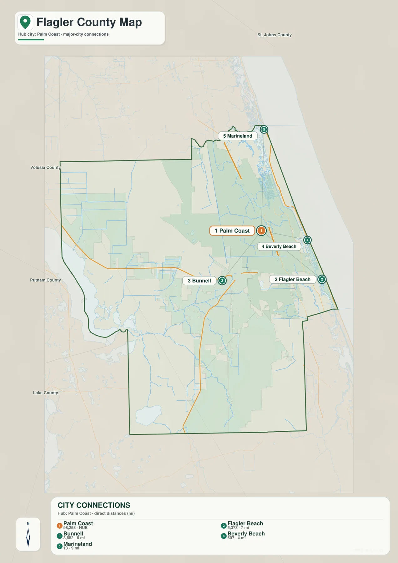
Bunnell is a good example of why municipal size and visible development are different measures. Its legal boundary can cover a broad area even though the built-up center is far smaller than Palm Coast’s continuous neighborhoods. The city map is therefore best read as a relationship map, not as a ranking of how much street development each municipality contains.
The Atlantic Coast and Intracoastal Waterway Run Side by Side
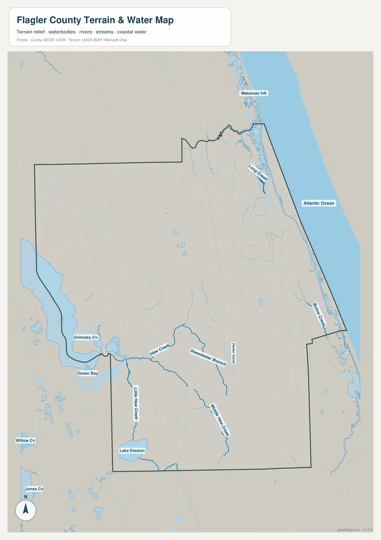
Eastern Flagler County has two parallel water edges. The Atlantic Ocean forms the outer coast, while the Matanzas River and Intracoastal Waterway run behind the barrier-island corridor. Palm Coast is largely on the mainland side, whereas A1A and the beach communities occupy the strip closer to the ocean. Long Creek, Bulow Creek, and the nearby Matanzas Inlet help show how tidal water cuts through this part of the county.
This arrangement explains several everyday map quirks. A neighborhood on the eastern edge of Palm Coast may look almost adjacent to A1A but still have no direct road across the water. It also allows marshes, tidal creeks, and preserves to remain very close to developed neighborhoods. The Pellicer Creek and Matanzas areas are good examples of places where natural water corridors and urban growth sit side by side.
West of Bunnell, Haw Creek and Lake Disston Replace Streets with Wetlands and Forest
The county’s western water pattern feels almost unrelated to the beach side. Haw Creek crosses the interior, with Sweetwater Branch, Middle Haw Creek, and Little Haw Creek adding smaller drainage lines. Lake Disston sits in the southwest, while Green Bay and Grimsley Cove appear near the western edge. The road network thins here because large areas are wet, forested, agricultural, or protected.
County material describes Haw Creek Preserve as a roughly 1,005-acre preserve along the creek, and Princess Place Preserve protects another large natural area in the northeast near the Matanzas and Pellicer Creek system. Seen together, those places explain the abrupt change from Palm Coast’s dense neighborhoods to much broader green spaces in the western and northern county.
Use the Road, Municipality, or Water View According to the Question
For a general county overview, the reference map is the best place to start because Bunnell, Palm Coast, Flagler Beach, the main roads, and neighboring areas appear together. The city-connections map works better when the goal is to compare the five municipalities and their straight-line relationships. The terrain-and-water view becomes more useful when the subject is Haw Creek, Lake Disston, the Intracoastal Waterway, tidal creeks, or the Atlantic shoreline.
No elevation map is included in this package, so exact elevations or contour lines should not be inferred from these files. The water map is also not a flood-zone, legal parcel-boundary, or navigation chart, and the road map does not provide live traffic or construction conditions. Within those limits, the maps work well for county profiles, classroom material, trip orientation, and documents that need a clear geographic reference.
For printing or larger documents, use the ZIP below instead of relying only on the smaller web previews. The archive contains the A3 high-resolution JPG files that correspond to the county, city, and terrain-and-water maps shown on this page. Each file can be used separately, so you only need to include the map that suits the task.
Frequently Asked Questions
Why does Bunnell look smaller than Palm Coast even though it is the county seat?
Bunnell is the administrative center, but Palm Coast has far more residents and a much denser network of planned neighborhoods, parkways, and canals. County-seat status and visible street density measure different things, so the two places naturally look very different on the map.
Why can’t every Palm Coast neighborhood connect directly to A1A?
The Matanzas River and Intracoastal Waterway lie between much of Palm Coast and the A1A corridor. Drivers have to use actual bridge crossings, such as SR 100 toward Flagler Beach or the Palm Coast Parkway/Hammock Dunes connection farther north. A short line across the water is not the same as a road connection.
Are the 6- to 9-mile labels on the city map driving distances?
No. They are direct straight-line distances from Palm Coast to Bunnell, Flagler Beach, Beverly Beach, and Marineland. Actual road distance can be longer because of waterways, bridge locations, and the shape of the road network.
Map File Information
Download one ZIP containing the three A3 high-resolution JPG files that match the county map, city map, and terrain-and-water map shown on this page.
- Included Files: County map, city map, and terrain-and-water map JPGs
- File Type: ZIP containing 3 JPG files
Related Maps
- Arcadia Roads and Peace River | DeSoto County Florida Map
- Baker County Florida Map
- Blountstown, SR 20, and the Apalachicola River | Calhoun County Florida Map
Sources
- Flagler County Government — county overview
- U.S. Census Bureau — Flagler County QuickFacts
- Flagler County Government — five municipalities
- City of Palm Coast — city and canal overview
- Florida Department of Transportation — I-95 exit list
- Flagler County Government — Haw Creek Preserve
Green Map creates custom-edited map images using open geographic data sources such as geoBoundaries, Natural Earth, OpenStreetMap, and government open data. These maps are edited visual materials, not raw data files, and are provided for education, documents, presentations, and graphic reference.