The DeSoto County Florida Map is easiest to read by starting with Arcadia. State Road 70 crosses the county east to west through the county seat, while US 17 provides the main north-south reference. The Peace River runs just west of Arcadia, giving the city a clear relationship to both transportation and water. Brownville appears north of Arcadia and Southeast Arcadia is labeled just to the south, while the rest of the county is much more lightly settled. This page uses only the three maps supplied in the package: the county reference map, the simplified city map, and the terrain-and-water map. Download the high-resolution A3 JPG map ZIP from the file box below when you need the full-size versions of all three maps.
Table of Contents
Arcadia Sits Where the County’s Main Road Directions Come Together
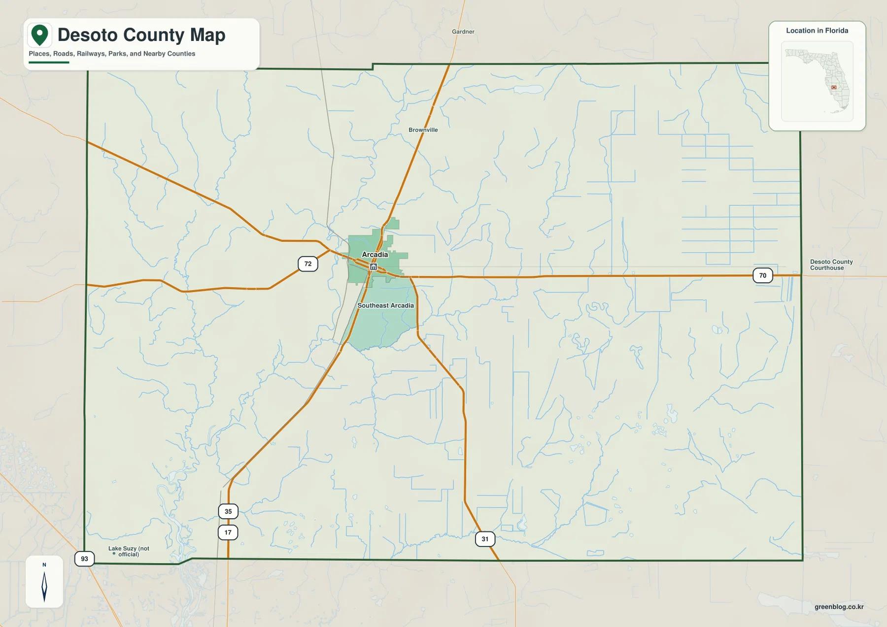
On the general county map, Arcadia is slightly northwest of the geographic center and serves as the clearest reference point for the road network. SR 70 crosses the county from west to east through Arcadia and continues toward Highlands County. US 17 runs north-south through the Arcadia area, linking the Hardee County side with Charlotte County to the south. SR 72 and SR 31 add other directions, but SR 70 and US 17 are the simplest lines to locate first.
Brownville is labeled north of Arcadia and Southeast Arcadia appears immediately to the south. These names are useful for local orientation, but the package’s city map does not rank them as separate major cities. They are better read as communities around the Arcadia-centered settlement area. Looking at them together with the main roads helps explain why the county’s developed labels cluster around the center while much of the outer county remains lightly labeled.
The surrounding county names also help with regional orientation. Hardee County is north, Highlands County east, Glades County southeast, Charlotte County south, Sarasota County west, and Manatee County northwest. This arrangement makes the main route relationships easy to remember. US 17 continues through the Hardee-DeSoto-Charlotte direction, and the Peace River enters from the north and continues south toward Charlotte Harbor.
Large Gaps Between Labels Reflect a Rural Development Pattern
The Census information already supplied in the package lists 33,976 residents in the 2020 Census, 636.70 square miles of land, and a 2020 density of 53.4 people per square mile. Those figures help explain the visual spacing on the map. The large areas between settlement labels are not missing towns; much of DeSoto County consists of ranches, agricultural land, wetlands, and woodland rather than continuous subdivisions.
The DeSoto County land-use material included in the package describes development as following major roads such as US 17, SR 70, SR 72, SR 31, and CR 769. That pattern is visible on the general map. Arcadia and nearby communities sit at or near the road corridors, while broad rural tracts remain between them. This is a better way to interpret the map than expecting the even spacing of communities that might appear in a more densely suburban county.
A Lake Suzy label appears near the southwestern edge with a “not official” note on the map itself. It is therefore best treated as a location aid rather than as proof of an incorporated municipality. The separate city map makes this distinction especially clear by ranking only Arcadia as a major city. The two map types work together: the county map shows more local labels, while the city map keeps the municipal picture simple.
The City Map Highlights Arcadia as the County’s Main Urban Reference
The city map is intentionally sparse. Arcadia is marked as number one and the CITY INDEX shows 7,707. Around the outside are the neighboring counties—Hardee, Highlands, Glades, Charlotte, Sarasota, and Manatee—but no other internal major-city marker is shown. This does not mean DeSoto County has no other communities. It means the map is designed to show Arcadia as the principal urban reference rather than reproduce every place name from the general map.
That emphasis fits Arcadia’s role as the county seat, where government, services, and important road connections are concentrated. Brownville and Southeast Arcadia help fill in the local settlement pattern on the general map, but they are not treated as equivalent ranked city entries. The map therefore gives a quick administrative and regional view without the visual clutter of the full county reference map.
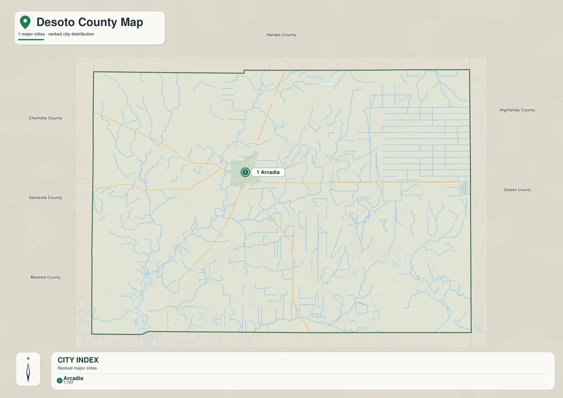
This simplified view is useful when a presentation or county profile needs one clear settlement reference. If the task requires smaller communities, road numbers, or the Peace River, the county or water map is the better choice. The maps are not competing versions of the same graphic; each removes some detail so a particular relationship becomes easier to see.
Peace River, Horse Creek, and Joshua Creek Organize the Western Water System
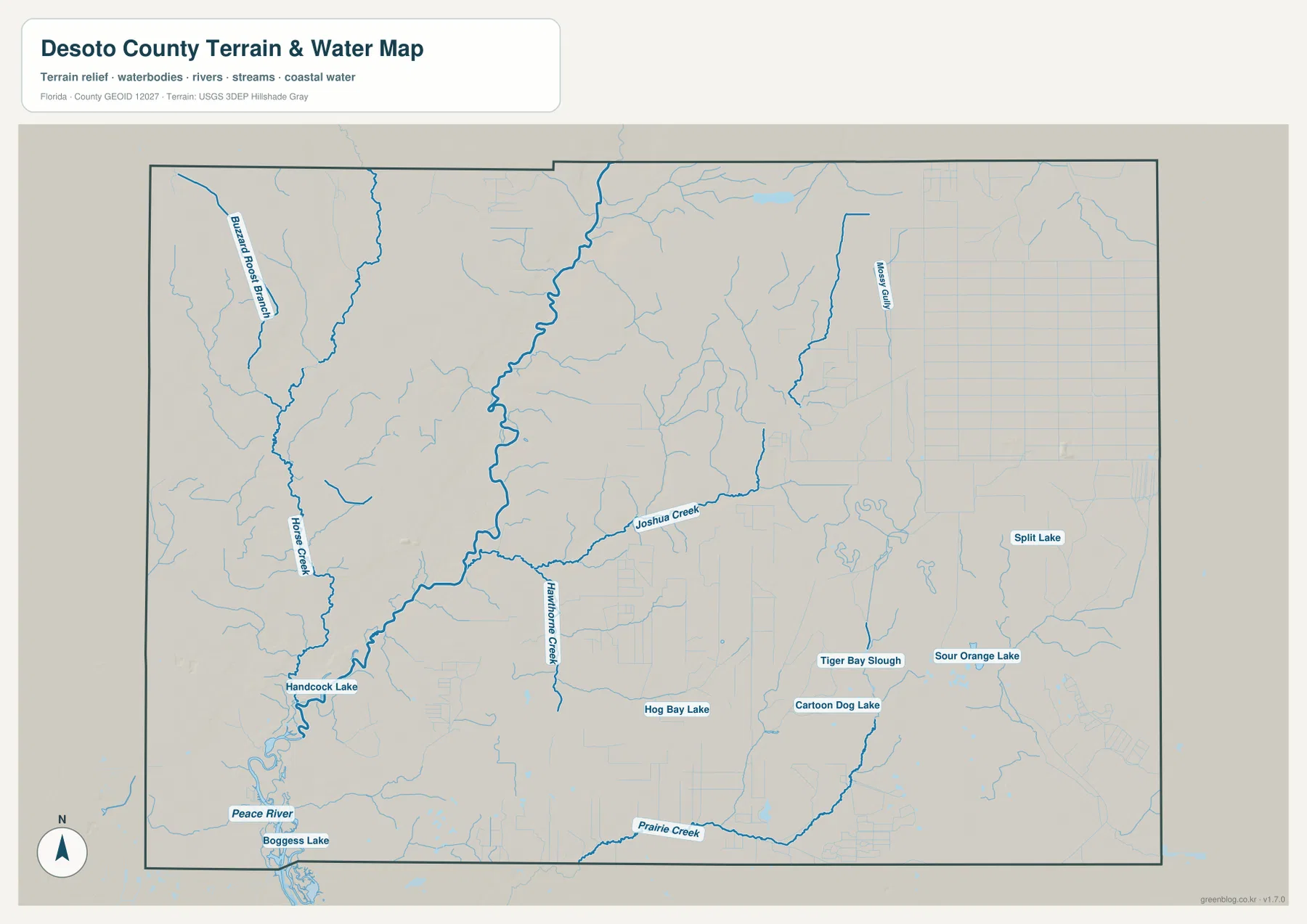
The terrain-and-water map gives the Peace River the strongest visual weight. The river enters from the north, passes west of Arcadia, and continues toward the southern county boundary. Horse Creek flows down the western side and connects with the larger river system, while Joshua Creek comes from the east toward the central river corridor. These named tributaries make the water map much more informative than the thin blue lines on the road map.
Other labeled features include Hawthorne Creek, Prairie Creek, and Messy Gully. The southeast shows Split Lake, Sour Orange Lake, Tiger Bay Slough, and Cartoon Dog Lake, while Hancock Lake and Boggess Lake appear toward the southwest. Together they show that DeSoto County is not drained by a single river alone. Smaller creeks, sloughs, ponds, and wet lowlands are spread across the county and feed into a broader Peace River landscape.
The Southwest Florida Water Management District source supplied in the package treats the SR 70 area at Arcadia as an important reference for the Lower Peace River. The existing county material also describes a wider floodplain downstream from Arcadia, while the Florida DEP Peace River Refuge source documents riverine wetland and forest environments. These sources support what the map suggests: land beside the river is not simply the same as the agricultural ground farther away from the channel.
Roads and Waterways Together Explain Why Arcadia Is the Best Map Anchor
SR 70 and US 17 show how people move through the county, while the Peace River and tributaries show how the natural landscape is organized. Looking at both at once makes Arcadia’s location much clearer. The city sits where the road network is most recognizable, but the Peace River runs just to its west and gives the same area a strong river-valley setting. Brownville and Southeast Arcadia also sit close enough to this central road-and-water relationship to be useful secondary references.
Seasonal water conditions can change the appearance and behavior of this landscape. The existing package notes that Peace River and tributary flows tend to rise during the southwest Florida wet season. Even so, the water map on this page is only a county-scale geographic reference. It is not a FEMA flood map, parcel survey, engineering drainage plan, or navigation chart. Site-specific flood or property questions require current official county and federal data.
Choose the Map Based on Whether You Need Roads, Arcadia, or Waterways
Use the county map when the task is to locate Arcadia, Brownville, Southeast Arcadia, road numbers, and the surrounding county boundaries in one view. Use the city map when Arcadia’s place in the county is the main question and extra labels would only add clutter. Use the water map when the Peace River, Horse Creek, Joshua Creek, and smaller lakes or sloughs are the important features. Choosing one map for the question usually produces a clearer handout or presentation than trying to combine every layer.
No elevation map is included in this package, so exact elevations or contour lines should not be inferred from these files. The road map does not provide live traffic or construction information, and the water map is not designed for legal boundaries or flood-zone decisions. Within those limits, the three maps work well for county overviews, classroom material, travel orientation, and documents that need a clear visual reference for settlements, roads, and waterways.
For printing or larger documents, use the ZIP below instead of relying only on the smaller web previews. The archive contains three A3 high-resolution JPG files corresponding to the county, city, and water maps shown on this page. Each JPG can be used separately, so a project can include only the map that fits the task.
Frequently Asked Questions
Why does the city map show Arcadia as the only major city?
The supplied city map ranks Arcadia as number one and lists 7,707 in its city index. Brownville and Southeast Arcadia are useful labels on the general map, but they are not shown as equivalent ranked-city entries on the city map.
Which side of Arcadia does the Peace River pass?
The Peace River passes west of Arcadia and continues south through the county. SR 70 crosses the area east-west, so viewing the road and river together is the easiest way to understand the county seat’s relationship to the river corridor.
Can the water map be used to determine flood zones or property lines?
No. It is a county-scale reference for rivers, creeks, sloughs, and lakes. Flood risk requires current FEMA or county hazard data, and parcel boundaries require the county property GIS or a survey.
Map File Information
Download one ZIP containing the three A3 high-resolution JPG files that match the county map, city map, and terrain-and-water map shown on this page.
- Included Files: County map, city map, and terrain-and-water map JPGs
- File Type: ZIP containing 3 JPG files
Related Maps
- Baker County Florida Map
- Blountstown, SR 20, and the Apalachicola River | Calhoun County Florida Map
- Brevard County Map
Sources
- U.S. Census Bureau QuickFacts — DeSoto County, Florida — population and land-area reference
- DeSoto County land-use and development record — road-oriented development pattern reference
- Florida Department of Transportation — DeSoto County Map — major-road and county-location reference
- Southwest Florida Water Management District — Lower Peace River — Arcadia and lower-river reference
- Florida Department of Environmental Protection — Peace River Refuge — riverine wetland and habitat reference
Green Map creates custom-edited map images using open geographic data sources such as geoBoundaries, Natural Earth, OpenStreetMap, and government open data. These maps are edited visual materials, not raw data files, and are provided for education, documents, presentations, and graphic reference.