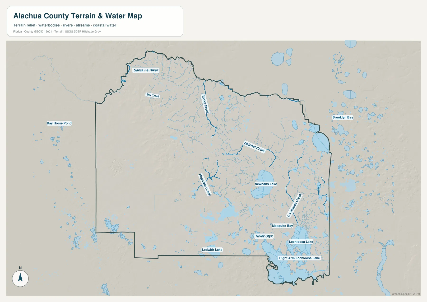
If you are looking for an Alachua County Map, Gainesville is the easiest place to start. The county sits in inland north-central Florida, with Gainesville near its center and smaller communities spread in several directions: High Springs to the northwest, Alachua to the north, Newberry to the west, and Waldo and Hawthorne toward the east. This page includes a general county map for roads and boundaries, a cleaner city map for comparing the main population centers, and a terrain-and-water map that emphasizes the Santa Fe River, Newnans Lake, Lochloosa Lake, and named creeks. After reviewing the local geography below, you can also download the matching A3 high-resolution JPG files in a single ZIP archive.
Alachua County is not a continuous urban area radiating evenly from one downtown. Gainesville is clearly the largest center, but the western and northwestern communities are separated by broad rural and conservation landscapes, while the eastern side has its own chain of smaller places and extensive wetlands and lakes. South of Gainesville, the approach to Micanopy crosses the Paynes Prairie area, creating a sharp break between the city and the southern part of the county. Looking at the road and water maps together makes these contrasts much easier to understand than a list of place names by itself.
Table of Contents
Gainesville Anchors the County Road Network
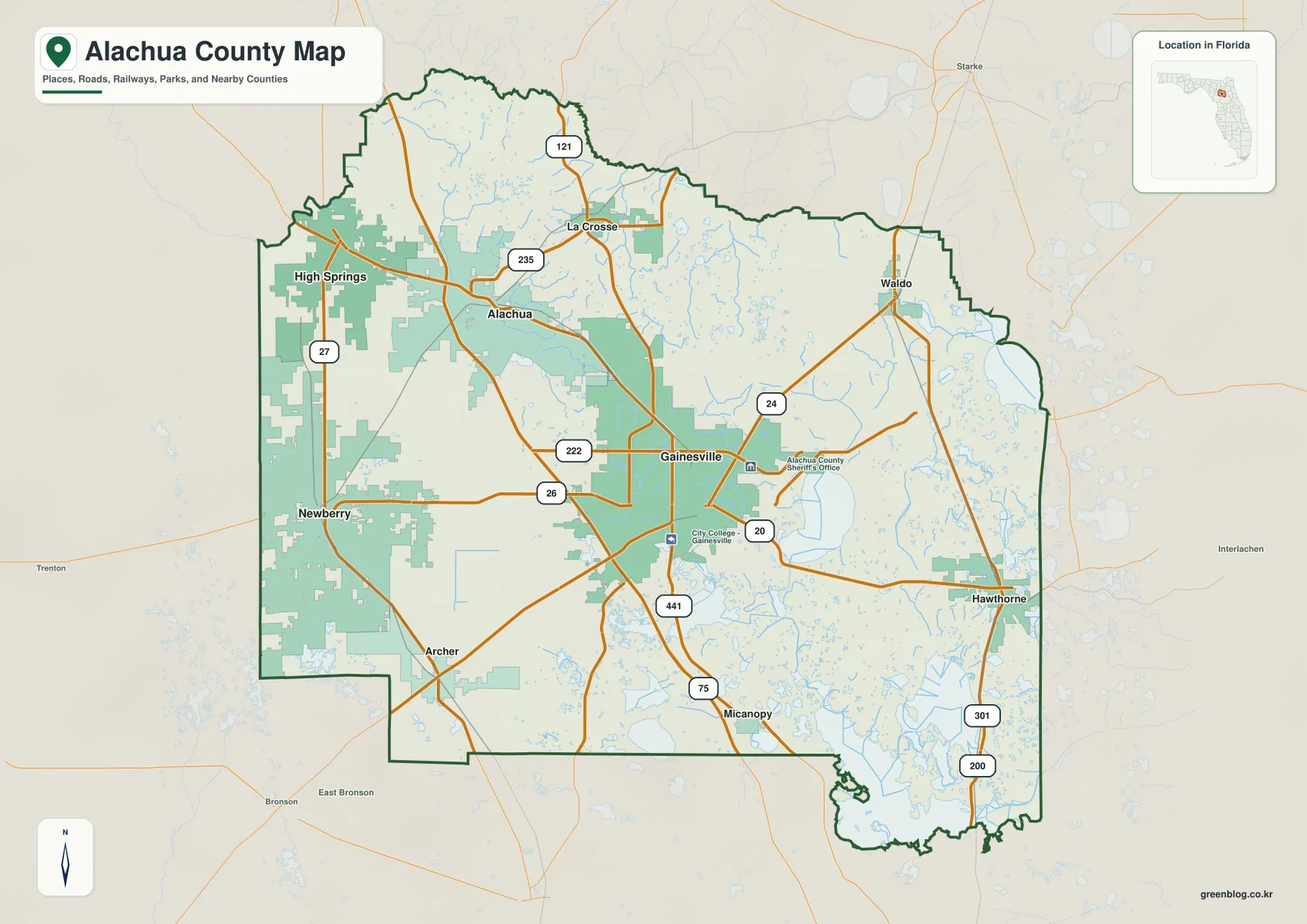
On the general county map, Gainesville is the strongest orientation point. Interstate 75 runs along the west side of the city and continues north toward Alachua and south toward the Micanopy area. U.S. 441 follows a similar north-south direction through the central part of the county, so the relationship between Gainesville and Alachua is easy to trace. These routes also show where the more developed central corridor gives way to the broader rural and conservation landscapes beyond the city.
The western side uses a different set of connections. Newberry and High Springs are linked back toward Gainesville through U.S. 27/U.S. 41 corridors and a network of state roads, including SR 26, SR 121, SR 222, and SR 235. SR 26 is especially useful as an east-west reference between Gainesville and Newberry, while roads farther north help explain how Alachua and High Springs connect to the county’s northwest corner. A traveler who looks only at I-75 would miss much of this western pattern, which is why the smaller numbered roads matter on a county-scale map.
East of Gainesville, U.S. 301 becomes a much more important reference. Waldo lies near the northeastern side of the county, and Hawthorne is farther south along the eastern side. SR 20 and SR 24 provide additional east-west connections from the Gainesville area toward the eastern communities. Archer, southwest of Gainesville, and Micanopy, to the south, help complete the picture by marking two directions that are easy to overlook when the larger cities receive most of the attention.
A City Pattern That Stretches West and East
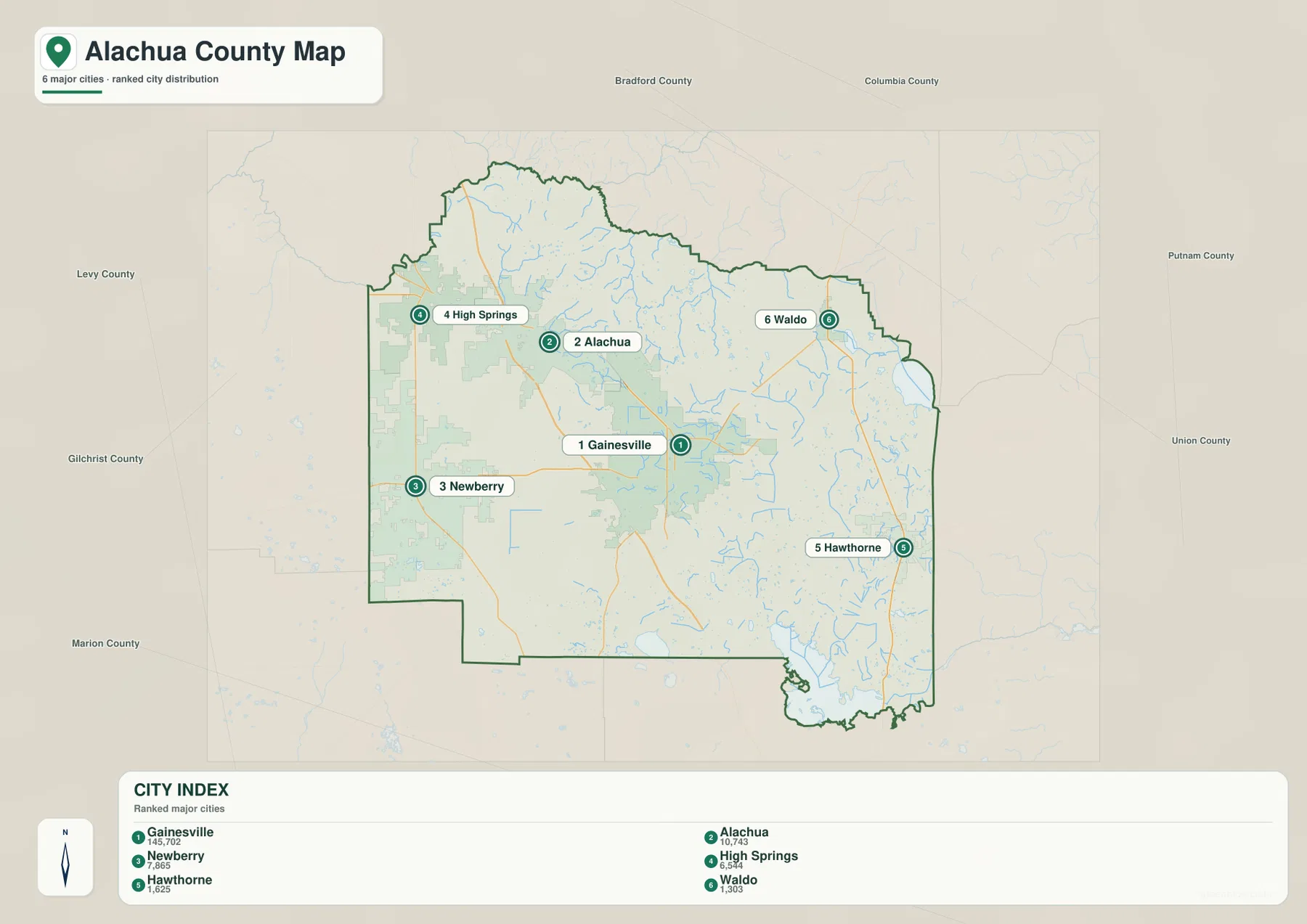
The city map removes much of the road detail and makes the settlement pattern easier to compare. Gainesville occupies the central position and is by far the largest of the six ranked cities shown. Alachua is north of Gainesville and sits along the same broad I-75/U.S. 441 corridor. Newberry lies to the west, while High Springs is farther northwest near the outer edge of the county. That arrangement shows that the western half is not one continuous suburban belt; instead, several distinct communities are separated by open land and smaller roads.
Waldo and Hawthorne create a second pattern on the eastern side. Waldo is northeast of Gainesville and close to the county boundary, while Hawthorne is farther south and also near the eastern edge. On the general map, Archer and Micanopy add two smaller reference points outside the six-city ranking. Archer helps orient the southwest, and Micanopy marks the approach to the southern boundary beyond Paynes Prairie. Together, these places show why describing Alachua County only as “the Gainesville area” leaves out a large part of its geography.
The surrounding county labels on the city map are useful as well. Bradford and Columbia appear beyond the north and northeast, Putnam and Union are to the east, Marion is to the south, and Levy and Gilchrist are to the west. High Springs makes more sense when viewed in relation to Gilchrist and Columbia, while Waldo and Hawthorne are naturally associated with the eastern county line and the direction of Bradford and Putnam. The map therefore works not just as a list of municipalities, but as a quick way to see which communities are close to the outer edge and which are more central.
From the Santa Fe River to the Lochloosa Lake Country
The water map reveals a different set of landmarks from the road map. The Santa Fe River follows the northern side of the county, with smaller waterways such as Mill Creek and Rocky Creek feeding through the northern landscape. High Springs lies in the northwestern part of the county, close to the broader Santa Fe River and springs region. Around Gainesville, Hogtown Creek and Hatchet Creek provide smaller local water references, showing that the central urban area is also crossed by a network of streams even though the largest named river is farther north.
East of Gainesville, Newnans Lake is one of the most prominent water bodies on the map. Farther southeast, Lochloosa Lake and Right Arm Lochloosa Lake occupy a broad wet area near the county’s eastern and southern sides. Lochloosa Creek, River Styx, and Mosquito Bay are labeled nearby, reinforcing how much denser the pattern of water becomes in this part of the county. A road-only map can make the Gainesville-to-Hawthorne corridor look relatively simple, but the water map shows a landscape filled with lakes, creeks, marshy ground, and small water bodies between and around those communities.
Ledwith Lake appears closer to the southern boundary, while Brooklyn Bay and many smaller water bodies are visible beyond the eastern side. The western half of the county has water features too, but the east and southeast show a much more concentrated blue pattern. For practical orientation, it helps to think of three broad water reference areas: the Santa Fe River in the north and northwest, the smaller Gainesville-area creeks and Newnans Lake near the center-east, and the Lochloosa system in the southeast. That simple division matches what is actually visible on the map and makes the many labels easier to place.
This terrain-and-water map is intended for general geographic reference. It is useful for seeing where named rivers, lakes, and creeks are located, but it should not be treated as a flood-hazard map, parcel map, legal boundary survey, or navigation chart. For those purposes, use the relevant official agency products. For trip planning, classroom work, or understanding the relationship between roads and natural features, however, it adds information that the other two maps intentionally leave in the background.
Paynes Prairie Creates a Clear Break South of Gainesville
South of Gainesville, Paynes Prairie is one of the county’s most important natural reference areas. Florida State Parks describes Paynes Prairie Preserve State Park as a large prairie preserve south of Gainesville, with access near Micanopy. On the county map, Gainesville and Micanopy can look fairly close in straight geographic terms, but the land between them is not a continuous strip of urban development. The presence of the preserve helps explain why the southern edge of the Gainesville area changes so quickly into a much more open landscape.
Alachua County is also associated with limestone, groundwater, and sinkhole features. Devil’s Millhopper Geological State Park, northwest of central Gainesville, protects a large sinkhole and interprets the local karst landscape. The maps on this page are not geological or engineering products, so they do not measure underground drainage or survey-grade elevations. Still, this background is useful when thinking about why springs, wetlands, depressions, and small water bodies are such common parts of the county’s natural setting.
These conservation areas also influence how the county feels on the ground. The central city has dense roads and developed neighborhoods, while the southern and eastern sides include broad protected or wet landscapes that interrupt the urban pattern. A visitor moving from Gainesville toward Micanopy or Hawthorne therefore crosses more than a simple change in city names. The road network, wetlands, lakes, and preserved land all combine to create distinct local areas within a single county.
Reading Alachua County Beside Its Neighbors
Alachua County borders Columbia, Union, Bradford, Clay, Putnam, Marion, Levy, and Gilchrist counties. Those neighboring names provide useful orientation because several Alachua County communities sit close to the outer boundary. High Springs is in the northwest, where the directions of Gilchrist and Columbia matter. Waldo is near the northeastern side and Hawthorne is farther south along the eastern side, making Bradford and Putnam useful regional references. Micanopy lies toward the southern part of the county, where Marion County becomes the next major county-level reference.
This boundary context is especially helpful when following roads beyond the county line. Gainesville is central enough that many routes radiate outward, but the smaller outer communities often connect more directly with nearby counties than a Gainesville-centered view might suggest. Checking the county border before tracing a highway or state road helps prevent confusion when the same route continues into another jurisdiction. The general map and city map work well together for this purpose: one provides road detail, while the other makes the relative position of the outer communities easier to see.
Which Map Works Best for Your Task?
Start with the general county map when you need the broadest view of roads, municipalities, the county boundary, and nearby places. It is the best choice for following I-75, U.S. 441, or U.S. 301 and for locating Newberry, High Springs, Archer, Micanopy, Waldo, and Hawthorne around Gainesville. The city map is more efficient when your main question is simply where the larger communities sit relative to one another. If rivers, lakes, and creeks are the priority, the water map provides much more useful detail, especially around the Santa Fe River, Newnans Lake, and Lochloosa Lake.
- Roads and county orientation: use the general map for Gainesville, I-75, U.S. 441, U.S. 301, outer municipalities, and county boundaries.
- City comparison: use the city map to compare Gainesville, Alachua, Newberry, High Springs, Hawthorne, and Waldo with less visual clutter.
- Water features: use the terrain-and-water map for the Santa Fe River, Newnans Lake, Lochloosa Lake, named creeks, and the wetter eastern landscape.
Keeping the maps together is useful for classroom reference, trip planning, local geography study, or printing a county reference sheet. The maps are complementary rather than interchangeable: the road map provides the best travel framework, the city map simplifies settlement patterns, and the water map adds natural features that are easy to miss elsewhere. The ZIP below contains the corresponding A3 high-resolution JPG files so you can save the full set and use the version that fits your purpose.
Frequently Asked Questions
Where is Gainesville within Alachua County?
Gainesville is near the center of Alachua County and is the county seat as well as its largest city. I-75 and U.S. 441 pass through the central corridor, and several state roads extend outward from the city, making Gainesville the most useful reference point for locating the smaller communities.
Which water features stand out most clearly on the map?
The Santa Fe River is the major named river along the northern side. Newnans Lake is prominent east of Gainesville, while Lochloosa Lake and the surrounding creeks and bays stand out in the southeast. Hogtown Creek and Hatchet Creek provide smaller water references closer to Gainesville.
How is High Springs positioned relative to Gainesville?
High Springs is northwest of Gainesville and much closer to the county’s northwestern edge and Santa Fe River area. It sits away from the main Gainesville-Alachua I-75/U.S. 441 corridor, so the western road network and the directions of Gilchrist and Columbia counties are useful for understanding its position.
Map File Information
The ZIP contains the A3 high-resolution JPG versions of the general county map, city map, and terrain-and-water map shown on this page. They can be saved for printing, classroom reference, trip preparation, or general geographic use.
- File Type: JPG
Related Maps
Sources and References
- Alachua County official history — background information about the county and its development.
- U.S. Census Bureau TIGER/Line Shapefiles — official geographic data used for county boundaries, roads, and place references.
- USGS National Hydrography — official reference information for rivers, lakes, streams, and related hydrographic features.
- Florida State Parks — Paynes Prairie Preserve State Park — official information about the prairie preserve south of Gainesville.
- Florida State Parks — Devil’s Millhopper Geological State Park — official context for the county’s limestone and sinkhole landscape.
Green Map creates custom-edited map images using open geographic data sources such as geoBoundaries, Natural Earth, OpenStreetMap, and government open data. These maps are edited visual materials, not raw data files, and are provided for education, documents, presentations, and graphic reference.