Treutlen County is a small southeast Georgia county where one place, Soperton, provides a useful starting point for reading the landscape. The general map shows the county boundary, the main roads that converge near Soperton, and selected nearby place names. A separate water map brings out the Little Ohoopee River, creeks, ponds, and smaller streams, while the elevation map shows a modest but visible pattern of ridges and low valleys. Four high-resolution A3 JPG maps—county, city, water, and elevation—are available together in the ZIP download on this page.
The maps work best as a set because no single image has to carry every label at the same visual weight. The road map makes the transportation pattern easy to follow. The city map strips the view back to Soperton and the neighboring counties. The water map reveals a dense network of tributaries that can be easy to overlook on the general map, and the relief image explains why those streams occupy particular low corridors. Reading them together gives a clearer picture of a rural county organized around one small city, several regional roads, and gently rolling terrain rather than a large urban center.
Table of Contents
Soperton is the clearest anchor for the county road network
On the general county map, Soperton sits south of the geographic middle of Treutlen County and stands out because several numbered roads meet or pass close to it. Routes marked 29, 78, 15, 221, and 227 are visible around the city, while the 16/404 corridor crosses the county farther north in a broad east–west line. That arrangement gives the map a simple logic: find Soperton first, then follow the larger road in the direction of the part of the county you want to examine. The road network spreads outward through a much wider rural area, so the city remains an easy reference even when the destination is near a boundary.
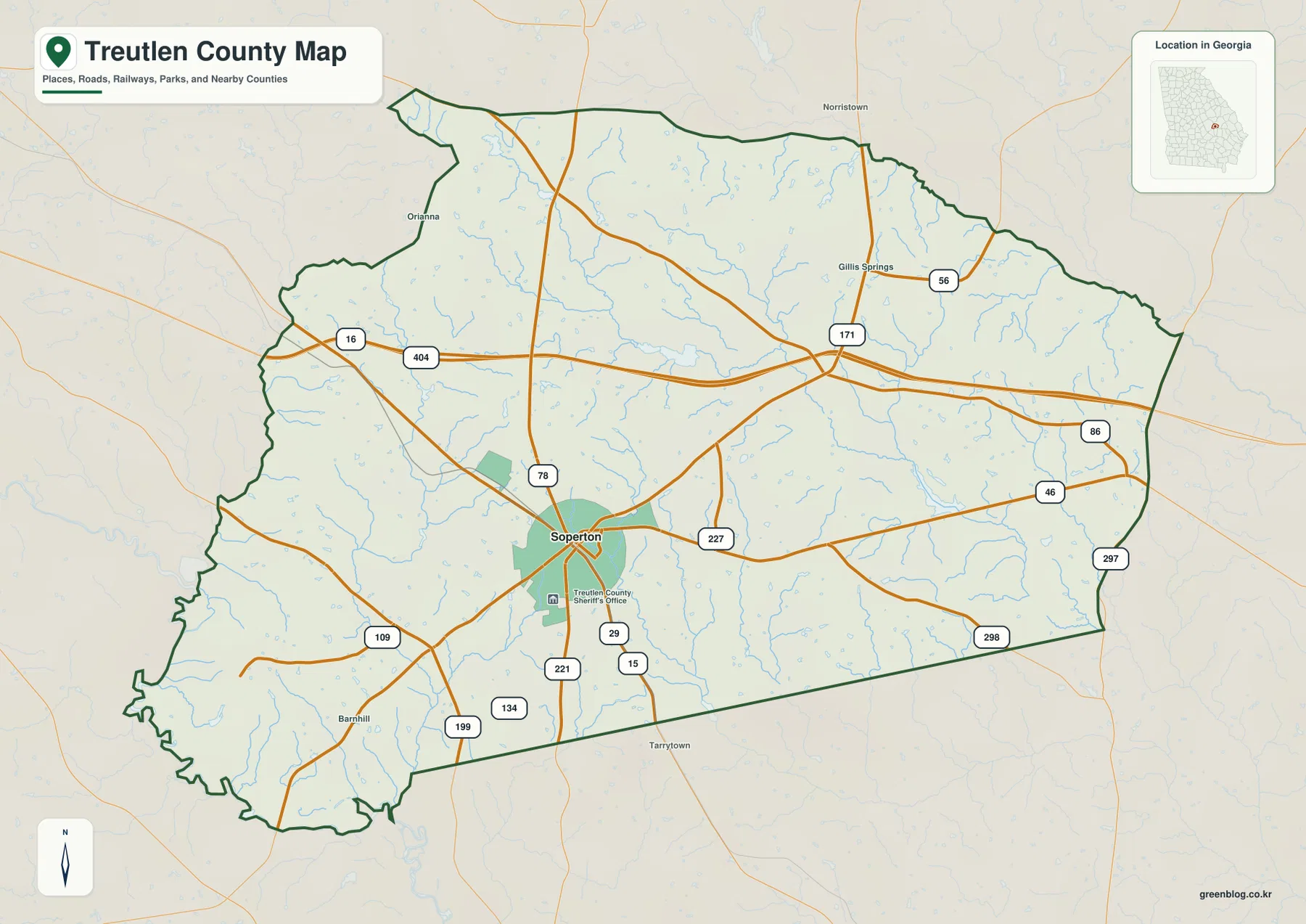
Several smaller place labels add useful orientation without turning the map into a street directory. Gillis Springs appears in the northeastern part of the county, while Orianna is shown near the western side. Norristown and Barnhill appear outside or near the county edge, helping the viewer separate interior places from surrounding communities. The boundary itself is also distinctive: the west and southwest sides are more irregular, while long straighter segments are easier to see along parts of the south and east. Those shapes are useful when comparing the county with a statewide map or checking whether a location is inside Treutlen County rather than just close to it.
The Treutlen County Sheriff’s Office is labeled near Soperton on the supplied general map. That label is not intended as a complete directory of public facilities, but it reinforces Soperton’s role as the county seat and administrative center. The map is intentionally selective. It does not attempt to show every local road, parcel line, residence, business, or unincorporated settlement, so it should not be used as a property survey or an address-level navigation map. Its strength is county-scale orientation: boundary, major roads, selected communities, streams in the background, and the relationship of those features to Soperton.
| State | Georgia |
|---|---|
| County | Treutlen County |
| County seat | Soperton |
| Neighboring counties shown | Johnson, Emanuel, Wheeler, Toombs, Montgomery, Laurens |
| Elevation shown on the map | About 39–113 m, mean 76 m |
| Download package | Four high-resolution A3 JPG maps in one ZIP |
A one-city map makes the surrounding rural area easier to understand
The city map ranks only one major city: Soperton. That is an important clue about how this particular map should be read. In a county with several large municipalities, a city map often becomes a comparison of multiple urban centers. Here the emphasis is different. Soperton is the single labeled city in the index, and the rest of the county spreads around it as a broad network of roads, streams, and rural land. The simplified view makes it easy to see that Soperton is not near the northern edge or the far eastern side; it lies in the southern half where several road connections come together.
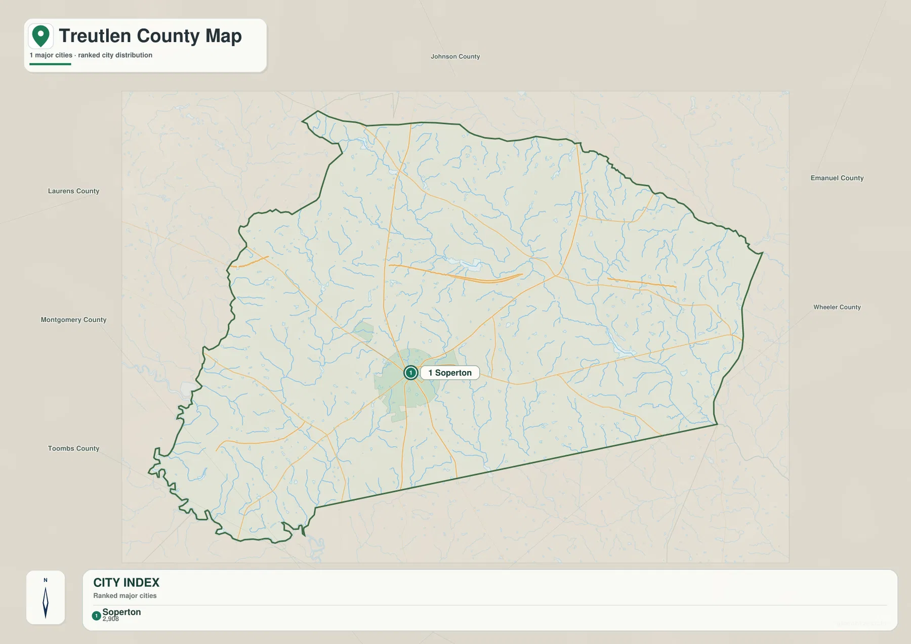
The labels outside the boundary are especially useful for regional context. Johnson County lies to the north, Emanuel County to the northeast and east, and Wheeler County to the southeast. Toombs County is shown toward the southwest, Montgomery County to the west, and Laurens County to the northwest. A reader trying to locate Treutlen County on a larger Georgia map can use those names as a ring of references. Instead of memorizing an abstract spot in southeast Georgia, it is easier to remember that Treutlen sits among these six neighboring counties with Soperton near its southern-central road network.
The supplied background material identifies Treutlen County as having been created in 1918 and describes a local setting shaped by agriculture, forestry, roads, and small-town services. The city map itself does not classify farmland or forest, so those land uses should not be inferred from blank areas on the image. What the map does show clearly is the scale relationship between one small administrative center and the land around it. That distinction matters: a simple city map is not missing information merely because it does not fill the county with place labels. Its purpose is to make the settlement hierarchy and county position easy to grasp.
Roads remain visible beneath the simplified city emphasis, and they help explain why Soperton is a practical point of reference. Lines extend north toward the 16/404 corridor, east and southeast toward the Wheeler and Emanuel sides, and west or southwest toward Montgomery and Toombs. The exact suitability of a route for travel still depends on current road information, but the broad pattern is clear enough for geographic orientation. For a classroom map, a county overview, or a report that needs to show where the county seat sits within the boundary, this version can be cleaner than the more detailed general map.
The Little Ohoopee River is only one part of a dense water network
The water map changes the visual emphasis completely. Roads fade into the background and a dense branching network of streams becomes the main feature. The Little Ohoopee River is labeled in the eastern half of the county, where it receives or runs near several smaller channels. Pendleton Creek and Long Creek are clearly named in the same broad area. Farther toward the center and south, Tiger Creek follows a longer path across the county, while Red Bluff Creek and Dead River appear toward the west and southwest. Many thinner tributaries have no labels, but their branching shapes show that drainage is widespread rather than concentrated in one major channel.
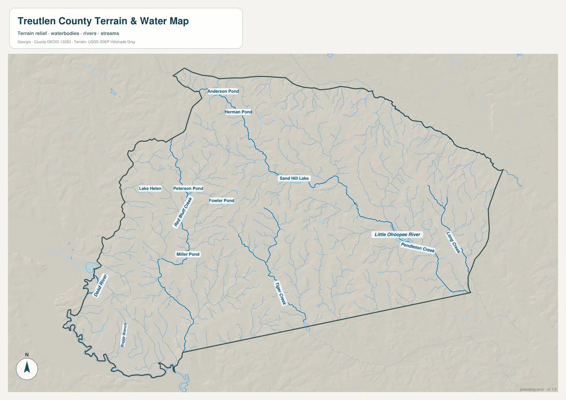
Small named water bodies are concentrated mostly across the northern and western portions of the map. Anderson Pond and Herman Pond sit near the north, while Lake Helen, Peterson Pond, Fowler Pond, and Miller Pond appear farther west or southwest. Sand Hill Lake is labeled closer to the upper central part of the county. None of these features dominates the county in the way a large reservoir would, but together they make the hydrology map much more informative than a simple river-only image. A viewer can see both the continuous stream network and the scattered ponds that occupy smaller local depressions.
Comparing the water map with the road map also helps separate two different kinds of geography. Major roads often cross the county in relatively direct lines, especially the east–west corridor north of Soperton, while streams branch and curve as they follow lower ground. In the northeast and east, thin tributaries repeatedly join larger channels before reaching the Little Ohoopee system. In the west, Red Bluff Creek and other unnamed streams cut across an area that looks much simpler when roads are the only strong lines. This comparison is useful when a project needs to explain why a place can be close by road but separated by several drainage channels.
This map is a location reference, not a flood-hazard or water-quality product. A blue line identifies a mapped watercourse or water feature, but it does not show current depth, discharge, seasonal conditions, water quality, or a legal floodplain boundary. Those questions require separate official datasets. For county-level reading, however, the map is very effective: it reveals that Treutlen County contains many small tributaries, gives names to several of the more important channels, and provides a basis for comparing watercourses with the valleys on the elevation map.
Relief from 39 to 113 meters is modest, but the county is not flat
The elevation map uses a local range of about 39 to 113 meters, with a mean elevation of 76 meters. Those numbers describe low-relief terrain compared with mountain counties, yet the shaded surface shows repeated rises and valleys across almost the entire county. Higher brown and tan areas are prominent through the center and northwest, where short ridges and knolls create a rougher texture. Lower green areas are strongest near the southwest edge and along several valleys toward the east. The result is a landscape that is gently rolling rather than uniformly level.
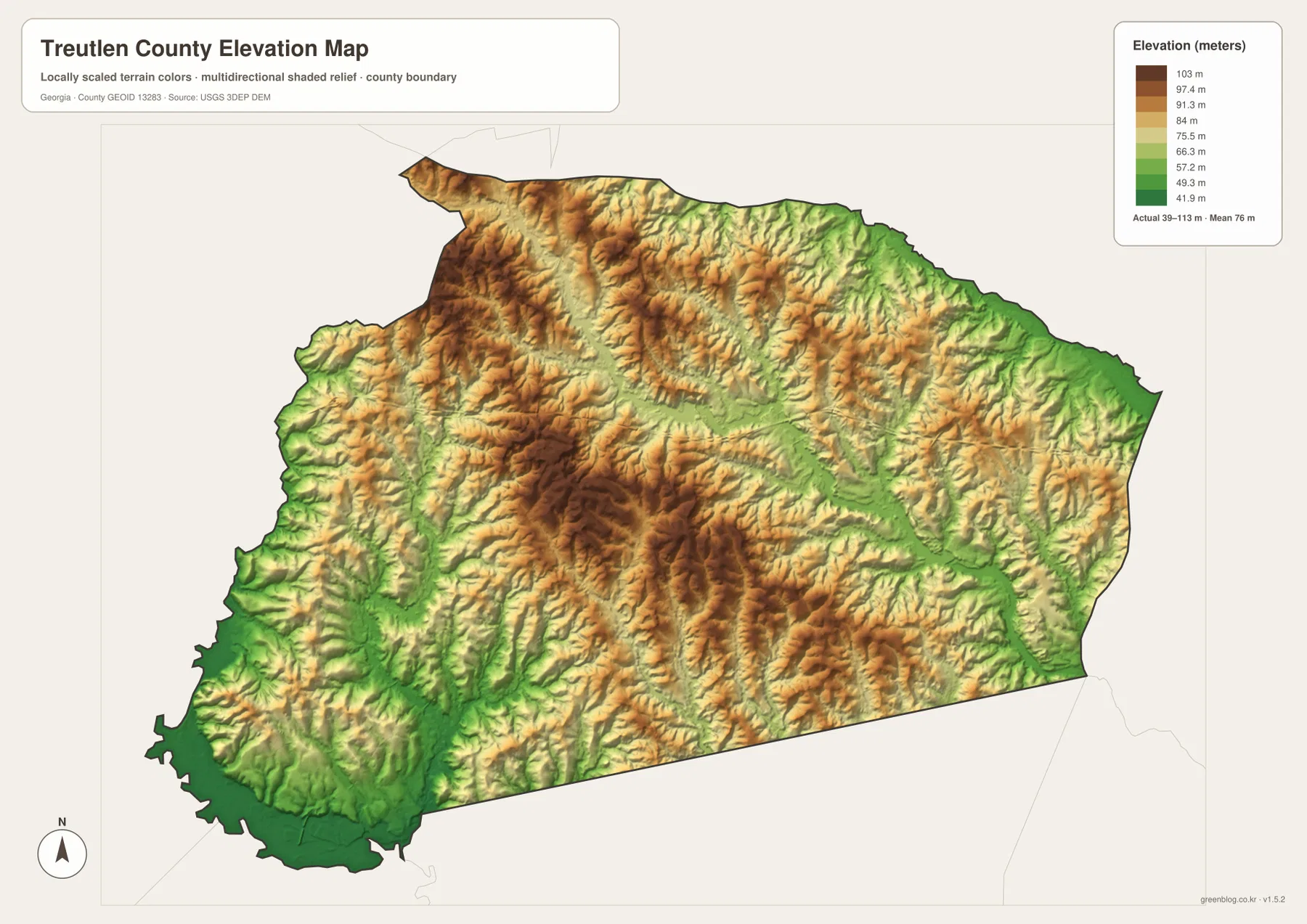
The central high area is especially useful for understanding the branching drainage visible on the water map. Several shallow valleys extend away from the higher ground, creating routes for small streams in different directions. The northern part of the county shows a similar mix of tan ridges and green troughs rather than a single continuous plateau. In the east, greener valley strips become more noticeable, matching the general area where the Little Ohoopee River, Pendleton Creek, and Long Creek are labeled. The two maps therefore reinforce each other without showing the same information in the same way.
The southwest corner is one of the clearest low areas on the elevation image. On the water map, Dead River and several tributaries occupy the same general side of the county. Moving back toward the center, the relief turns browner and more dissected, indicating higher ground cut by narrow valleys. The difference is not large enough to describe Treutlen County as mountainous, but it is enough to influence the shape of drainage and the appearance of the land. A flat road map can hide this detail, which is why the elevation layer adds useful context even in a county with a relatively narrow elevation range.
The relief image should not be treated as a parcel-level slope survey. Color represents relative elevation within the county, and the shaded surface makes small landforms easier to see; it does not provide a road-grade measurement or a construction suitability assessment. For general geographic work, its role is more straightforward. It identifies broad high and low areas, explains the visual relationship between ridges and streams, and helps the reader understand that the rural landscape around Soperton includes many subtle rises and depressions that are not obvious on the city map.
Choose the map by the question you need to answer
For a first look at Treutlen County, the general map is usually the most efficient because it combines the boundary, Soperton, road numbers, selected place names, and background streams. If the task is specifically to show the county seat and the neighboring counties without many extra labels, the city map is cleaner. A report about the Little Ohoopee River, local creeks, or ponds should use the water map, while a discussion of rolling ground, valleys, or relative height is better served by the elevation image. Each version reduces some information so the feature that matters most remains readable.
The maps can also be paired. The city and general maps work well together when explaining how Soperton relates to major roads and county boundaries. The water and elevation maps are a natural pair because the stream network follows the lower parts of the terrain. For a more complete county profile, all four can be viewed in sequence: first locate Soperton and the road system, then step back to the county’s regional neighbors, trace the major watercourses, and finally compare those waterways with the high and low terrain. This sequence avoids forcing every detail onto a single crowded image.
There are limits to what these files are designed to answer. They do not show individual parcels, legal property boundaries, every local road, current traffic conditions, flood zones, or live water levels. They are county-reference maps intended for orientation, education, regional description, printing, and visual support in reports or presentations. When a project requires an authoritative boundary or current technical dataset, the source links below provide useful starting points for Census boundary data, USGS hydrography, and USGS elevation information.
The webpage previews use WEBP so the images can load more efficiently in a browser. The downloadable package is different: it contains the four maps as high-resolution A3 JPG files, which are more convenient when a larger image is needed for printing or offline use. The download box below keeps the file information in one place rather than repeating it after every map.
Frequently Asked Questions
Why does Soperton stand out so strongly on the Treutlen County maps?
Soperton is the county seat, and the supplied city map ranks it as the one major city. The general map also shows several numbered roads meeting near it, so it becomes the easiest reference point for locating other parts of the county.
What named water features appear besides the Little Ohoopee River?
The water map labels Tiger Creek, Pendleton Creek, Long Creek, Red Bluff Creek, and Dead River, along with smaller water bodies such as Anderson Pond, Herman Pond, Sand Hill Lake, Lake Helen, Peterson Pond, Fowler Pond, and Miller Pond. Numerous unnamed tributaries are also visible.
Does the 39–113 meter elevation range mean Treutlen County is completely flat?
No. The county does not have mountain-scale relief, but the elevation map shows repeated low ridges and valleys. Higher ground is especially visible in the central and northwestern areas, while lower green corridors occur near the southwest and along several drainage valleys.
What is included in the downloadable ZIP?
The ZIP contains four high-resolution A3 JPG files: a general county map, city map, water map, and elevation map. The WEBP images in the article are lighter preview versions for browser viewing.
Map File Information
The Treutlen County package includes the general county map, city map, water map, and elevation map as high-resolution A3 JPG files. The images displayed in the article are WEBP previews; the button below downloads one ZIP containing all four JPG maps.
- File Type: Four high-resolution A3 JPG files
Related Maps
Sources and Data References
These external references provide county background and official starting points for boundary, hydrography, and elevation data. For current statistics or technical work, consult the source directly rather than relying on a static map image alone.
- U.S. Census Bureau QuickFacts – Treutlen County, Georgia
- New Georgia Encyclopedia – Treutlen County
- U.S. Census Bureau TIGER/Line Shapefiles
- USGS National Hydrography
- USGS 3D Elevation Program
Green Map creates custom-edited map images using open geographic data sources such as geoBoundaries, Natural Earth, OpenStreetMap, and government open data. These maps are edited visual materials, not raw data files, and are provided for education, documents, presentations, and graphic reference.