You can download four high-resolution A3 JPG maps of Sumter County, Georgia in one ZIP from this page, with lighter WEBP previews used in the article. The maps separate the county boundary and major roads, the five ranked cities shown in the source map, waterways and millponds, and elevation. Americus is the clearest starting point: major routes radiate from the city, Plains lies to the west, Andersonville sits in the narrow northern extension, and Leslie and De Soto form a smaller pair of mapped places in the southeast.
Sumter County also has more terrain variation than a simple road map suggests. The elevation preview shows higher rolling ground across much of the west and northwest, while lower valleys spread through the center and become broader toward the east and southeast. The water map explains many of those low areas, because creeks and small impoundments follow the same branching valleys. Looking at the four maps together makes it easier to connect settlement, roads, drainage, and relief without treating any one map as a complete navigation or engineering source.
Table of Contents
Americus as the road hub in the middle of Sumter County
The county map makes Americus the most useful reference point for orientation. Route 49 continues north from the city, while Routes 30 and 280 head east and southeast. Routes 19 and 3 run south, and Routes 377 and 118 appear farther across the southern part of the county. To the west, Route 27 reaches the Plains area and Route 45 follows the southwestern side. Andersonville is shown in the narrow northern projection near Routes 228 and 271, while Route 195 appears around Leslie and De Soto in the southeast.
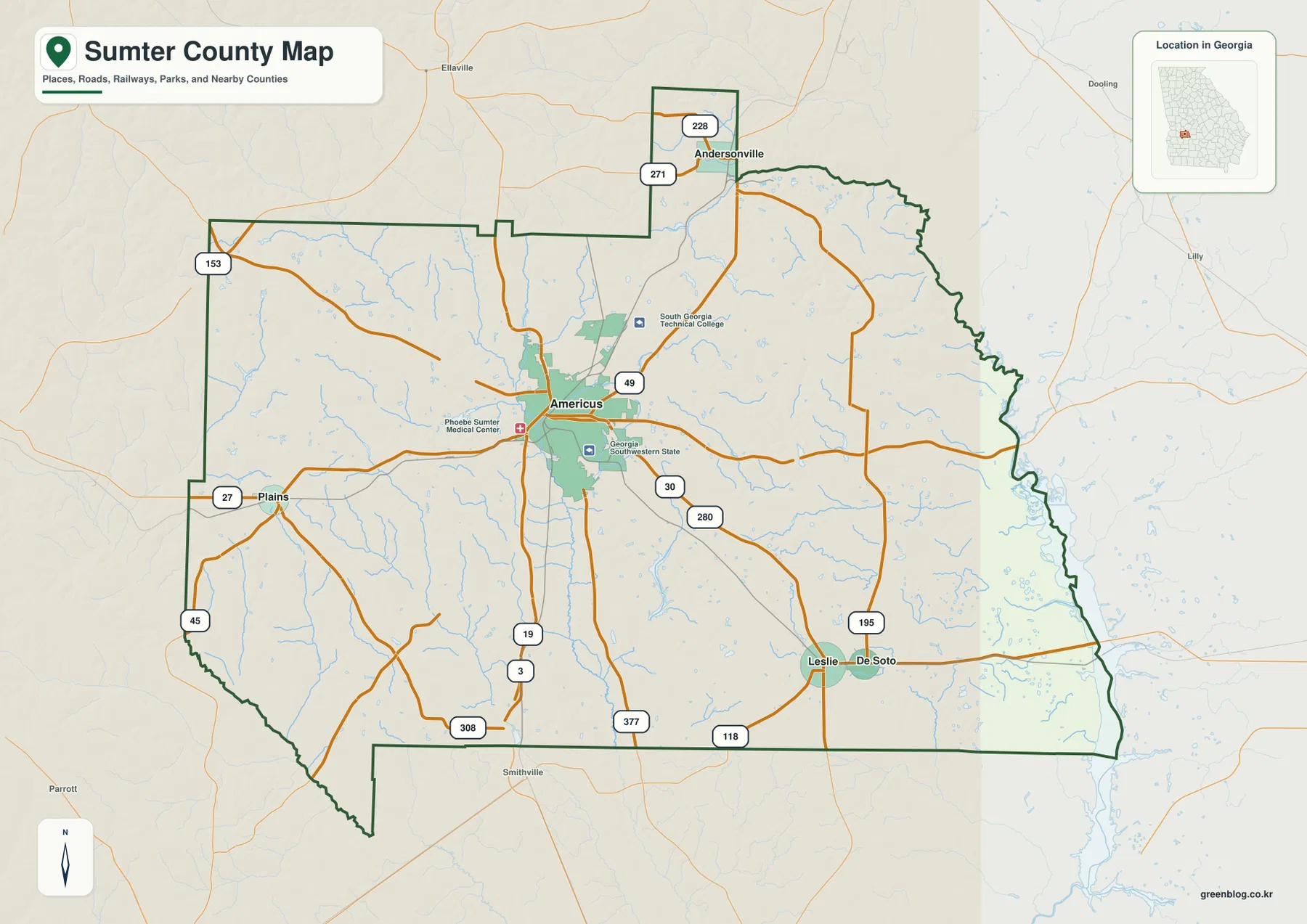
The road pattern is easier to read when the towns are used as anchors rather than treating every numbered route as a separate fact. Plains is west of Americus near Route 27. Andersonville is north of the main body of the county in the rectangular extension of the boundary. Leslie and De Soto are close to one another in the southeast, where Route 195 helps define their local setting. This map is therefore most useful for county-scale orientation and for seeing how the larger routes connect the mapped communities; it is not intended to replace turn-by-turn navigation or a complete local street map.
Several facilities are also labeled around Americus, including Phoebe Sumter Medical Center, South Georgia Technical College, and Georgia Southwestern State University. Their presence reinforces the role of Americus as the county’s main service and institutional center. The map does not show every campus entrance or neighborhood street, so anyone traveling to a specific facility should still use current directions.
Five mapped cities from Plains to De Soto
The city-distribution map ranks five places and gives a simple way to compare their relative size within the map dataset. Americus is listed at 15,813, followed by Plains at 750, Leslie at 510, Andersonville at 237, and De Soto at 99. These values should be read as the city-index figures used for this map rather than assumed to be the latest official population estimates. For current population statistics, the U.S. Census Bureau source linked below is the better reference.
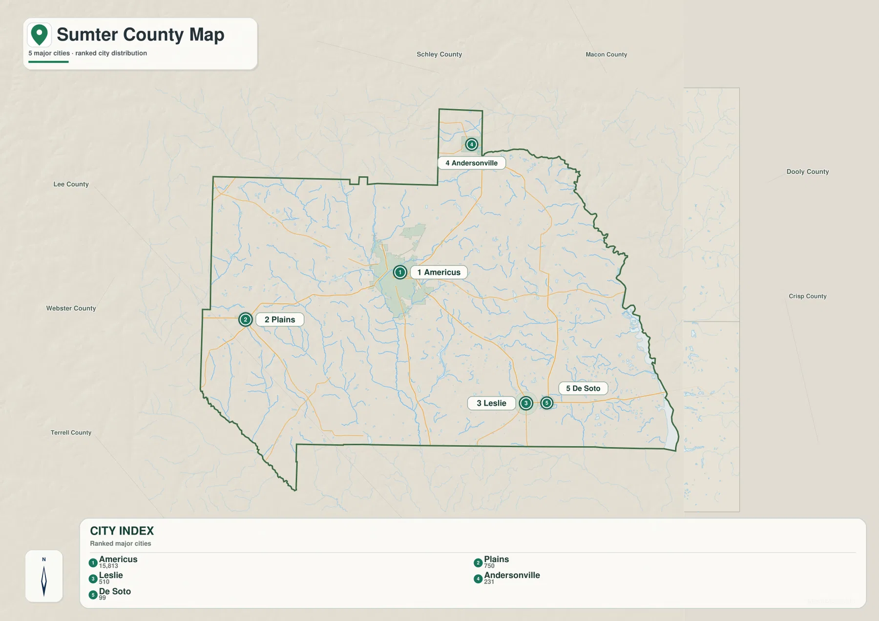
The five places are spread across the county rather than arranged along one corridor. Americus occupies the central area and works well as the base point for reading every other map. Plains is well to the west, Andersonville is separated to the north, and Leslie and De Soto sit near one another in the southeast. This distribution matters because the same arrangement appears again when roads, streams, and terrain are compared. Once the five places are located, it becomes much easier to describe whether a particular creek valley or higher ridge lies near the western, northern, central, or southeastern part of the county.
Plains and Andersonville are widely recognized names, but this map is not a tourism guide. Their main purpose here is geographic: they help define the western and northern parts of Sumter County. Leslie and De Soto perform the same job in the southeast. Americus, by contrast, combines the county-seat role with the largest city-index value on the map and the greatest concentration of major roads and labeled institutions.
Creeks, millponds, and the broad water corridor on the eastern edge
The water map shows a dense network of small streams rather than a county dominated by a single interior river. Branching creeks spread across the west, center, and east, and a broad water corridor follows much of the eastern edge. Lime Creek is clearly labeled in the eastern half, while Muckaloochee Creek and other central drainage lines cut through lower valleys. The pattern is useful because it shows why the elevation map contains so many narrow green channels between higher ridges.
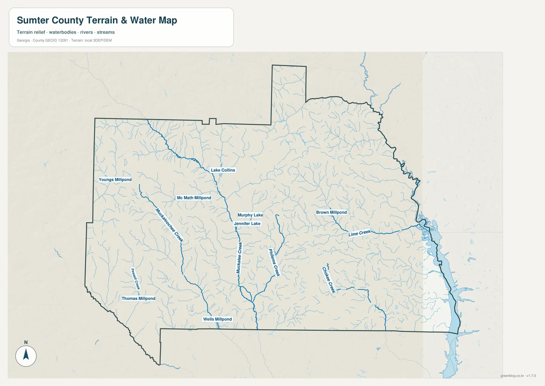
Several named ponds and small lakes are also visible. Lake Collins lies in the north-central area, with Murphy Lake and Jennifer Lake farther south. Youngs Millpond and Mc Math Millpond are mapped in the west, Brown Millpond is farther east, and Thomas Millpond and Wells Millpond appear in the southern part of the county. These scattered water bodies help distinguish the map from a simplified river-only view of the county. They also show how many small water features occur away from the largest river channel.
A mapped pond or creek should not be interpreted as a public recreation site. The water layer shows location, not ownership, access, flood risk, boating rules, or fishing permission. For hydrology, it is a county-scale reference; for recreation or property decisions, users should consult the relevant landowner, agency, or current official map.
Higher western uplands and lower eastern valleys
The elevation map gives an actual mapped range of about 71 to 181 meters, with a mean near 116 meters. The highest-looking terrain is concentrated across much of the west and northwest, where brown and tan hilltops are separated by narrow lower valleys. A long system of lower green corridors runs through the center, while the eastern and southeastern parts of the county contain broader low ground. The contrast is large enough to make the drainage pattern visible even before the water map is placed beside it.
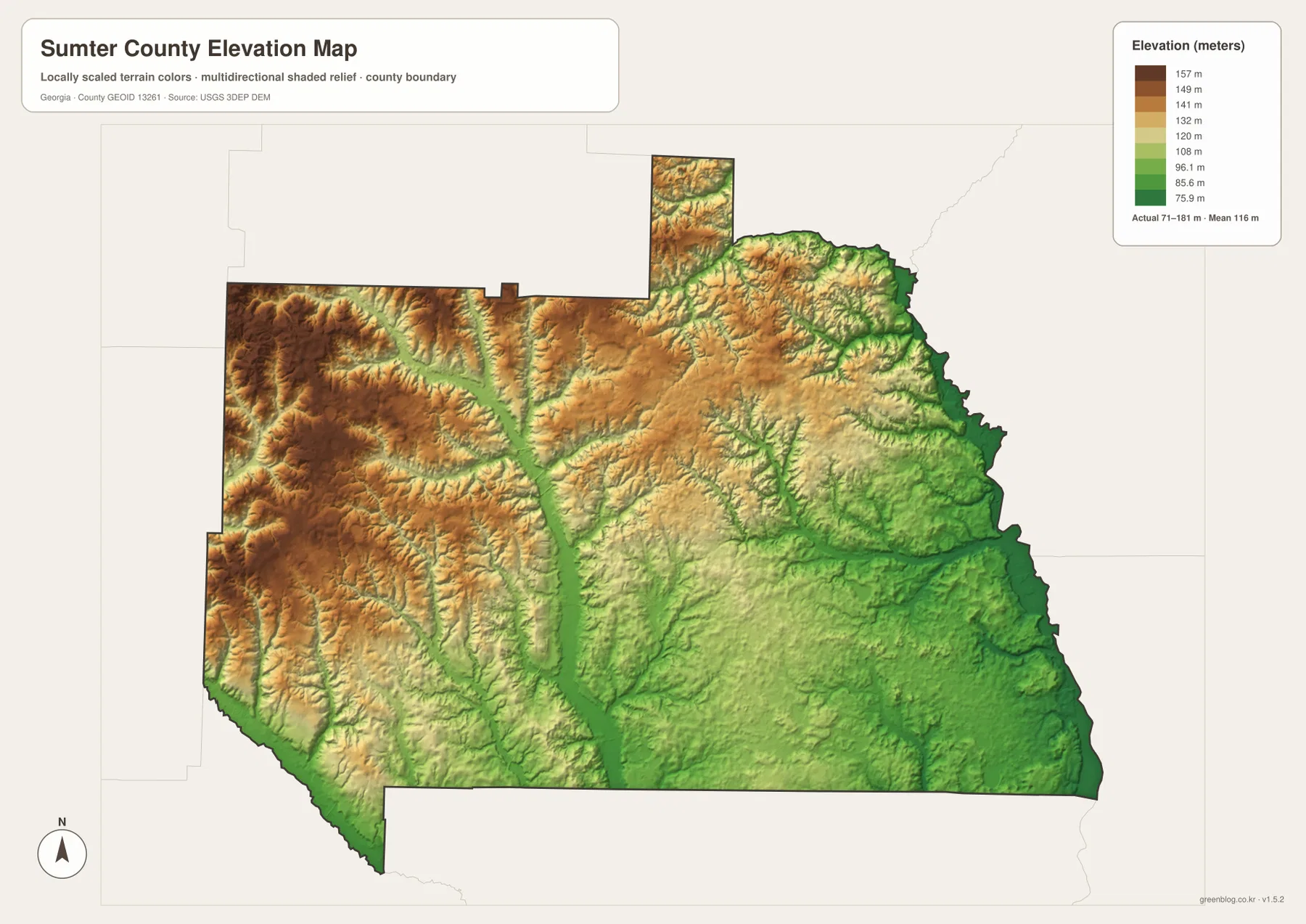
Comparing the water and elevation maps is especially useful in the central part of the county. Many of the green low corridors line up with the branching creeks, and the larger eastern water corridor sits beside some of the lowest terrain on the map. West of Americus and toward the Plains side, the land is generally higher and more strongly dissected by narrow drainage valleys. This does not mean every location in the west is high or every location in the east is low, but the broad county-wide trend is clear.
The elevation layer is intended for visual comparison of county relief. It should not be used as a substitute for survey-grade elevations, construction design, drainage engineering, or a parcel-level slope analysis. Those tasks require the original elevation dataset, more detailed terrain processing, and often field measurements.
Using the four maps together for local reference
A practical way to read Sumter County is to start with Americus on the county map, note the directions of the main numbered roads, and then locate Plains, Andersonville, Leslie, and De Soto on the city map. After that, the water map can be used to see which areas are divided by creeks or dotted with small ponds. The elevation map completes the picture by showing whether those waterways occupy low corridors and whether the surrounding ground rises toward the western uplands.
For example, the Plains side of the county combines western settlement with generally higher rolling terrain and numerous small drainage lines. Leslie and De Soto lie closer to the lower southeastern landscape, where the creek network becomes an important part of the map. Andersonville is memorable because it sits in the northern projection of the county boundary, while Americus remains the best reference for the road network and county services. These differences give each part of Sumter County a distinct map context without requiring a long list of every minor feature.
In a classroom or presentation, the county and city maps work well for explaining location and settlement, while the water and elevation maps are better for describing the physical landscape. For travel, the maps can establish the general direction of a destination, but current road conditions and turn-by-turn routes should come from a navigation service. For research, the linked Census, TIGER/Line, hydrography, and elevation sources provide the next step when more detailed or current data are needed.
Frequently Asked Questions
Which place is the best reference point for reading the Sumter County maps?
Americus is the county seat, the largest city in the city-index map, and the point where several major routes meet. It is the easiest place to use as a starting reference before locating Plains, Andersonville, Leslie, and De Soto.
How much elevation change is shown across Sumter County?
The elevation map shows an actual range of about 71 to 181 meters and a mean near 116 meters. Higher rolling ground is most extensive in the west and northwest, while lower valleys and broader lowlands are more common toward the east and southeast.
Can the millponds on the water map be treated as public recreation sites?
No. Names such as Lake Collins, Youngs Millpond, and Brown Millpond identify mapped water features, but the map does not establish public access, ownership, boating permission, or fishing rules. Those details require separate current information.
Sources and Reference Data
- U.S. Census Bureau QuickFacts for Sumter County
- New Georgia Encyclopedia: Sumter County
- New Georgia Encyclopedia: Plains
- U.S. Census Bureau TIGER/Line boundary and road data
- USGS National Hydrography
- USGS 3D Elevation Program
Map File Information
The ZIP contains four high-resolution JPG maps: county boundary and roads, ranked cities, waterways, and elevation. The article uses lighter WEBP previews, while the larger JPG files are better suited to printing, classroom use, presentations, and offline reference.
- Included Files: county map, city map, water map, elevation map
- File Type: four high-resolution JPG files in one ZIP archive
Related Maps
Green Map creates custom-edited map images using open geographic data sources such as geoBoundaries, Natural Earth, OpenStreetMap, and government open data. These maps are edited visual materials, not raw data files, and are provided for education, documents, presentations, and graphic reference.