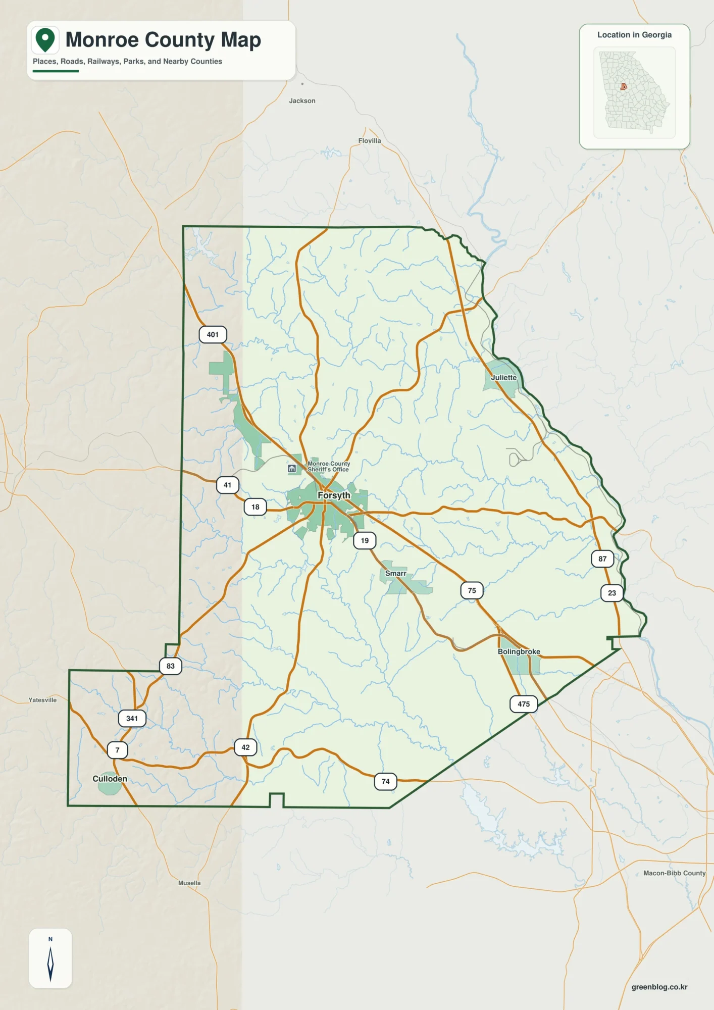
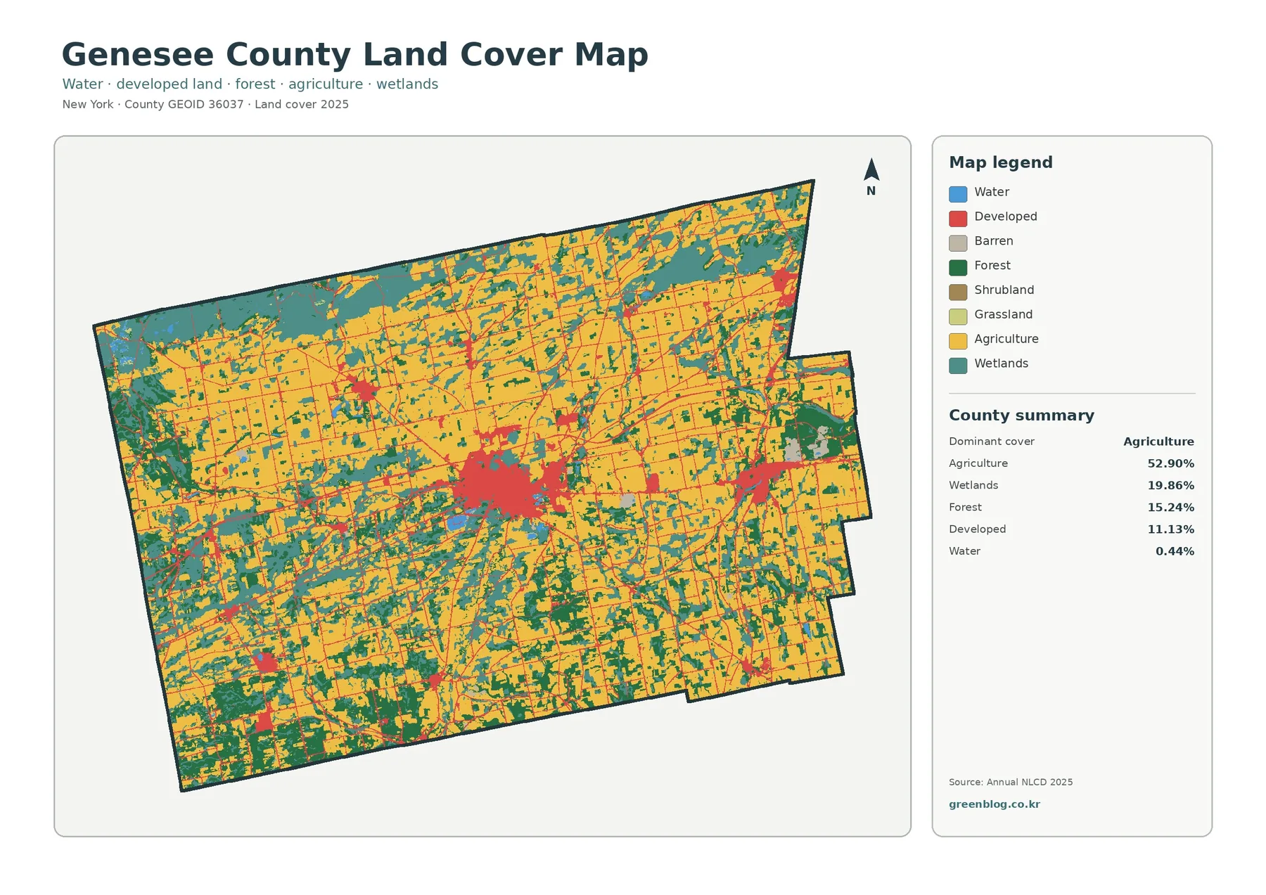
Jeff Davis County lies in southeastern Georgia with Hazlehurst as the county seat, Denton in the southwest, and the Altamaha River along the northern side of a heavily drained rural landscape. You can download four high-resolution A3 JPG Jeff Davis County maps from this page in one ZIP, including the county reference, city, water, and elevation versions. The previews below let you check Hazlehurst, Denton, Satilla, Graham, numbered roads, the Altamaha River and named creeks, plus terrain ranging from about 24 to 93 meters before opening the larger files.
Hazlehurst is the most practical starting point for reading the county. It sits north of the geographic center, with Denton well to the southwest, Satilla to the southeast, and Graham close to the eastern side. Routes 341 and 27 provide an east-west reference near Hazlehurst, while Route 23 continues south. Routes 135, 221, 107, and 268 help organize the western and southern interior, and Routes 19 and 289 provide additional eastern references. Between those roads, dozens of blue tributaries reveal that the open rural land is broken into shallow valleys rather than forming one featureless plain.
Table of Contents
Hazlehurst, Denton, and the County Road Pattern
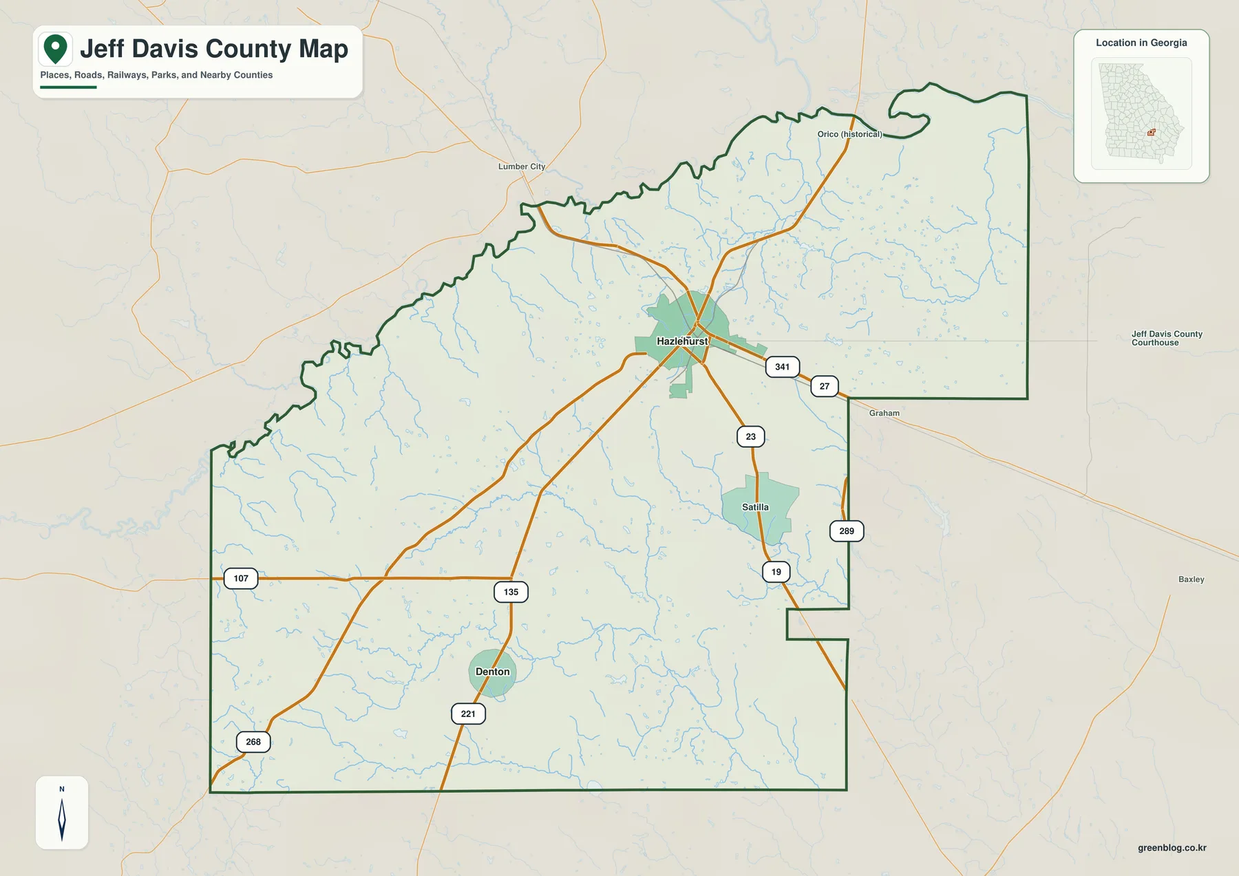
Hazlehurst is the largest developed area on the general map and the place where several road references converge. Routes 341 and 27 are labeled on the eastern side of the city, and Route 23 heads south through the central county. Route 135 crosses the interior toward the southwest, where Denton becomes an important local reference. Route 221 appears near the Denton side, while Route 107 crosses the western portion and Route 268 is shown farther southwest. The road layout gives Hazlehurst a clear central role without suggesting that every local street is included.
Southeast of Hazlehurst, Satilla appears as another developed place and Route 19 provides a useful location marker. Graham is labeled near the eastern boundary with Route 289 nearby. The northern map also includes an Orico historical label, while Lumber City and Baxley appear outside the county for orientation. These labels represent different kinds of places, so they should not be read as a single ranked city list. Their main value is helping readers move from the county seat toward the outer edges of the map.
The county outline is especially irregular on the north and east. The northern edge bends repeatedly around river and tributary terrain, while the eastern side includes both a broad projection and inward notches. Farther south and west, the boundary becomes simpler, but small streams continue to divide the interior. The reference map therefore works well for comparing roads and places first, then shifting to the water view to understand why so many parts of the county are cut by narrow drainage corridors.
Hazlehurst and Denton on the Ranked City View
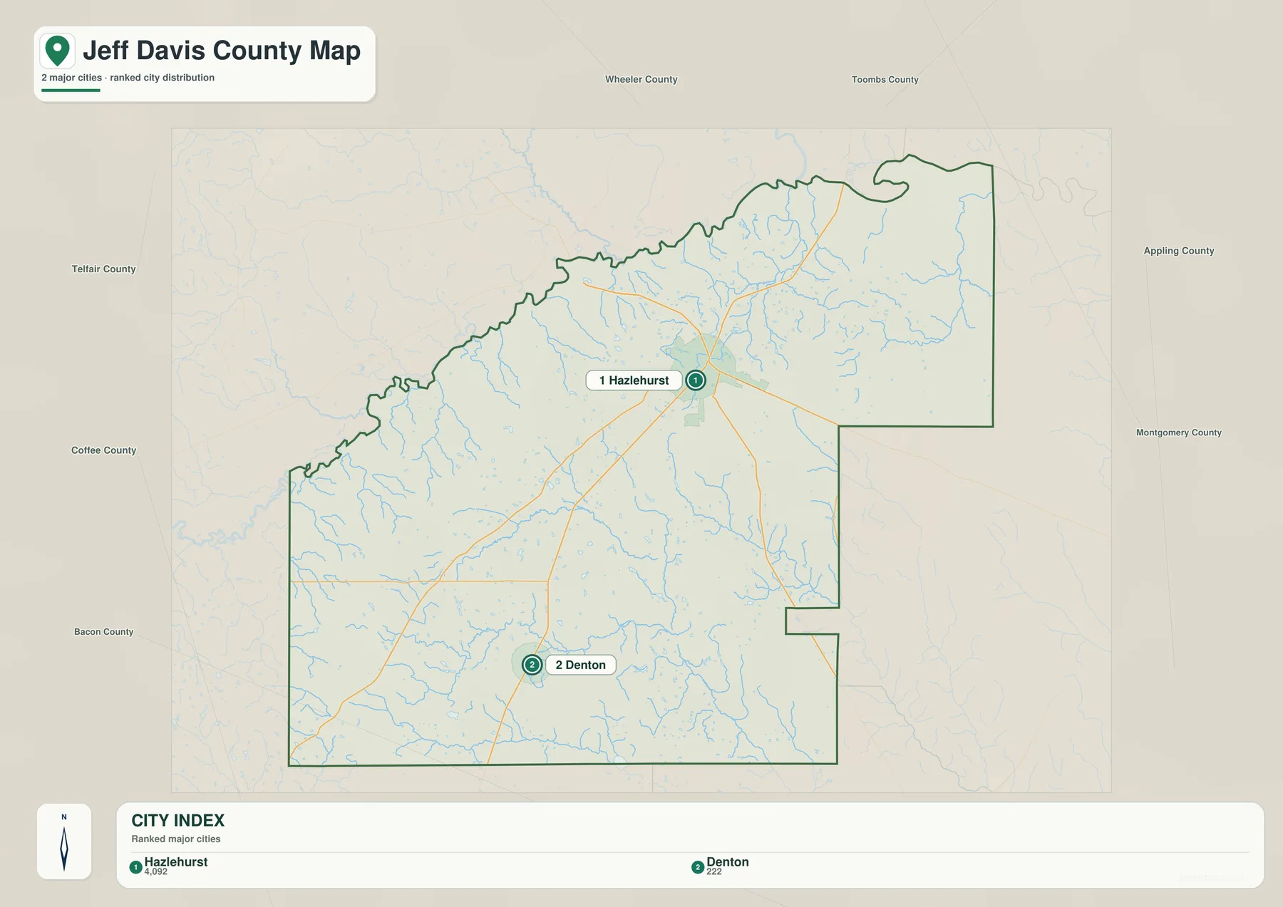
The city graphic removes most of the road and facility detail and ranks two places. Its CITY INDEX shows Hazlehurst at 4,092 and Denton at 222. Those figures are reproduced from the supplied map to explain the graphic; they are not newly verified population estimates for this article. For current official demographic figures, use the Census Bureau source listed in the reference section rather than treating the map values as a live population count.
Hazlehurst is both the county seat and the dominant city marker, positioned in the north-central part of the county. Denton is much smaller and lies in the southwest. The city map does not draw a measured connector line between them, so this article does not add an invented mileage. What the graphic does make clear is the strong difference in size and position: one city anchors the county’s main road network, while the other provides a smaller incorporated reference in the rural southwest.
Wheeler and Toombs counties are labeled along the northern side of the city map. Appling and Montgomery appear to the east, while Telfair, Coffee, and Bacon counties frame the western and southwestern sides. These labels are regional orientation aids rather than survey measurements. Because only two cities are ranked inside Jeff Davis County, the surrounding county names are particularly useful for seeing where Hazlehurst and Denton sit within southeastern Georgia.
| Map rank | City | Displayed value | General position |
|---|---|---|---|
| 1 | Hazlehurst | 4,092 | north-central county seat |
| 2 | Denton | 222 | southwest |
Altamaha River and the Creeks Crossing Jeff Davis County
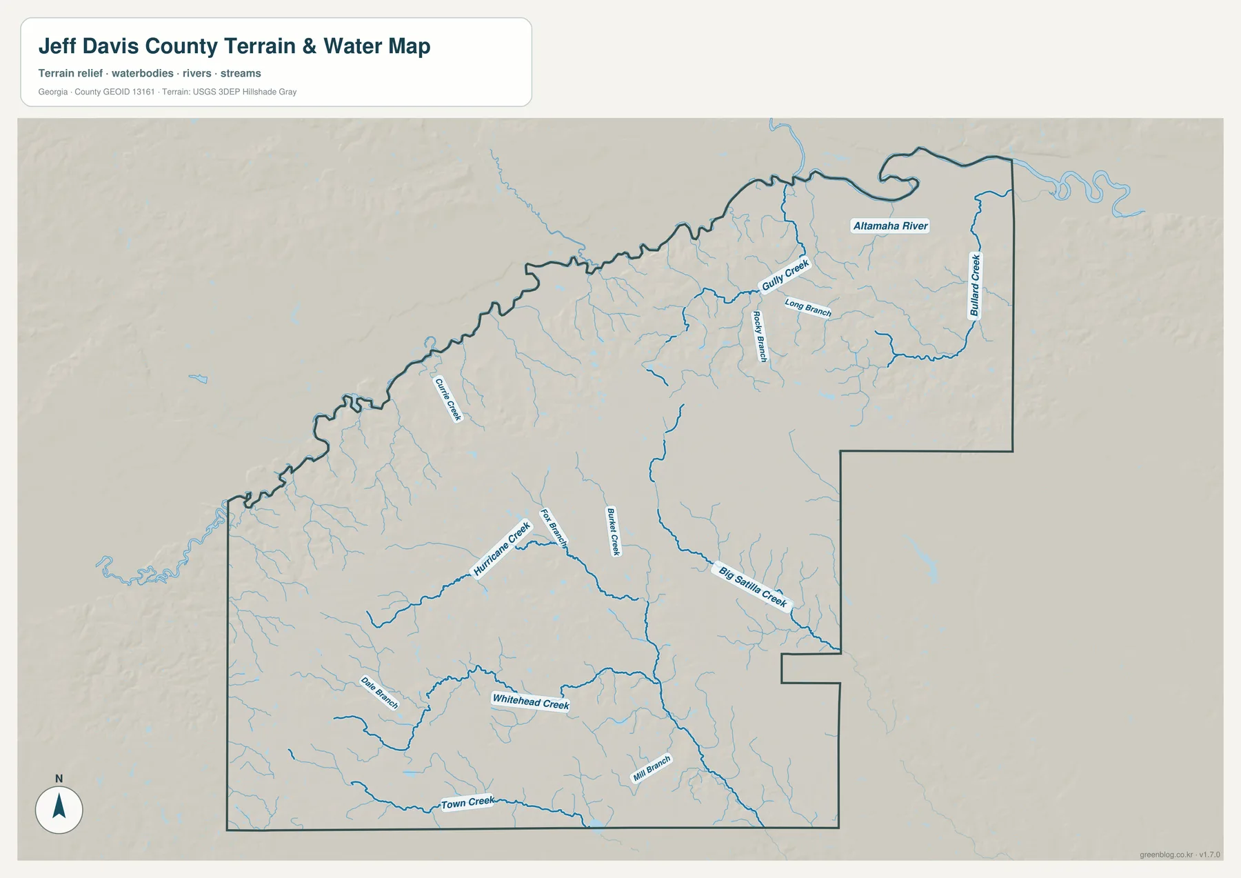
The Altamaha River is the strongest large-water reference on the supplied map. It bends along the northern and northeastern side of the county and helps explain the irregular shape of that boundary. Gully Creek is labeled in the north-central interior, with Long Branch and Rocky Branch close by. Bullard Creek follows a long north-south course near the eastern edge. Together, these features create a low, highly dissected northern landscape rather than a simple straight river boundary.
Farther west, Curtis Creek descends through the northwestern and west-central interior. Hurricane Creek becomes a strong reference across the central-southern part of the county, with Fox Branch nearby. Buffalo Creek lies farther east, and Big Satilla Creek forms another long channel through the southeastern interior. The map therefore contains several important creek valleys that are separate from the Altamaha River itself, making the county’s rural geography easier to understand by drainage names than by towns alone.
The southern half contains another set of named waters. Whitehead Creek stretches across the lower interior, Dale Branch lies to its west, and Town Creek follows a long route close to the southern boundary. Mill Branch is labeled above Town Creek. Many smaller tributaries remain unnamed at this scale. Their density is important because it shows why the southern and western countryside has so many shallow valleys even though the overall elevation range is modest.
This water map is meant for geographic orientation across the county. It should not be used to decide flood status for a parcel, identify a legal property edge, estimate channel depth, or determine whether a specific creek bank is publicly accessible. Those questions need the appropriate current records. Here, the most useful comparison is between the Altamaha River along the north and the Gully, Curtis, Hurricane, Buffalo, Big Satilla, Whitehead, and Town Creek corridors that divide the interior.
Elevation from About 24 to 93 Meters
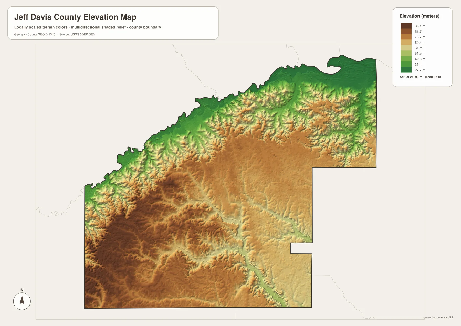
The elevation legend gives Jeff Davis County an actual range of approximately 24 to 93 meters, with a mean of 67 meters. The southwest and parts of the west-central interior contain the broadest brown and tan higher ground. Green lower terrain is strongest along the northern boundary and around the Altamaha River, with additional green ribbons following creeks through the middle and east. The county is low in absolute elevation, but the relief still shows a clear pattern of gently raised uplands separated by drainage valleys.
The northern side provides the easiest water-and-relief comparison. The Altamaha River corridor is consistently lower, and Gully Creek, Long Branch, Rocky Branch, and Bullard Creek occupy green cuts extending away from the river. That relationship explains why the northern county boundary appears so irregular on the general map: water follows low terrain and creates repeated bends, tributary junctions, and shallow valleys.
In the southwest, higher colors cover a wider area, but the surface is still broken by lower creek routes. Hurricane Creek, Whitehead Creek, and Town Creek cut green or lighter corridors through the surrounding uplands. Hazlehurst sits within mixed middle elevations rather than at the highest or lowest extreme. A useful summary is that the county generally rises away from the northern river lowlands, while individual creek valleys create local low paths throughout the interior.
The relief layer is suitable for comparing broad high and low areas across Jeff Davis County. It is not a substitute for a precise site elevation, engineering survey, road-design surface, or drainage plan. A parcel-level project needs finer elevation information and any field measurement appropriate to the work. For classroom geography, a county profile, or a presentation, the 24–93 meter range clearly shows the contrast between the low Altamaha side and the gently higher southwestern interior.
Hazlehurst and a Rural County Shaped by Roads and Water
The source material in the package states that Jeff Davis County was established in 1905 and describes forestry, agriculture, rail and highway access, and the Altamaha River basin as parts of its local background. The maps here do not measure timber production, farm acreage, freight activity, or economic output. Instead, they show the geography beneath that context: Hazlehurst at the county center of activity, Denton in the southwest, a road network spreading through rural land, the Altamaha River along the north, and many creek valleys crossing terrain that ranges from roughly 24 to 93 meters.
Hazlehurst ties the four map themes together. Routes 341, 27, and 23 provide the clearest road references around the county seat, while the city map shows Hazlehurst as the dominant ranked place. Moving north brings the Altamaha River and lower terrain closer; moving southwest reaches Denton and some of the county’s broader higher ground; moving southeast leads toward Satilla and the Big Satilla Creek side. Those relationships provide a more useful picture of Jeff Davis County than a short list of cities or a generic rural-county description.
The general map is the best starting point for places, roads, and the county outline. The ranked city view is cleaner for comparing Hazlehurst and Denton. The water map is more useful for the Altamaha River and the long list of named creeks, while the elevation map explains why those waterways occupy low corridors between gently higher uplands. Because all four files share the same county boundary, they work well as a set for classroom materials, local-history research, reports, and presentations.
Frequently Asked Questions
Which Jeff Davis County places appear in the CITY INDEX?
The supplied city view ranks Hazlehurst at 4,092 and Denton at 222. Hazlehurst is also the county seat, while Denton provides a smaller southwestern city reference.
Which waterways can be identified besides the Altamaha River?
Gully Creek, Curtis Creek, Hurricane Creek, Buffalo Creek, Big Satilla Creek, Whitehead Creek, and Town Creek are among the clearest labels. Long Branch, Rocky Branch, Fox Branch, Dale Branch, and Mill Branch add smaller local references.
What elevation range is shown for Jeff Davis County?
For Jeff Davis County, the relief legend spans about 24 to 93 meters, with the mean marked at 67 meters. The Altamaha River and northern tributaries occupy lower terrain, while the southwest and west-central interior contains broader higher ground.
What does the A3 map ZIP contain?
The archive includes four large JPG originals covering the county reference, Hazlehurst–Denton city view, waterways, and elevation. Keeping the subjects separate makes road labels, city positions, creek names, and relief easier to read when printed or placed in a document.
Map File Information
Jeff Davis County A3 Map Files
- Included Files: 4 high-resolution A3 JPG maps: county, city, water, and elevation
- File Type: JPG files in a ZIP archive
- Intended Use: Printing, education, presentations, and map-based projects
Related Maps
- Jeff Davis County Texas map | Fort Davis and Davis Mountains
- A Clinch County Map
- A Closer Look at the Decatur County Georgia Map
Jeff Davis County Data and Map References
- U.S. Census Bureau QuickFacts: Jeff Davis County – current official county statistics
- Jeff Davis County official website – county government and local information
- New Georgia Encyclopedia: Jeff Davis County – county history and the 1905 establishment date
- Census TIGER/Line boundary resources – county and neighboring-boundary reference geometry
- USGS hydrography resources – reference data for the Altamaha River and named creeks
- USGS 3DEP elevation resources – source elevation data for comparing the 24–93 meter terrain range
Green Map creates custom-edited map images using open geographic data sources such as geoBoundaries, Natural Earth, OpenStreetMap, and government open data. These maps are edited visual materials, not raw data files, and are provided for education, documents, presentations, and graphic reference.