Heard County lies in western Georgia, where Franklin serves as the county seat and smaller places such as Centralhatchee and Ephesus are separated by broad rolling terrain and numerous stream valleys. The four maps on this page divide that geography into readable themes. The general reference map shows Franklin, Centralhatchee, Ephesus, Glenn, major numbered roads, streams, and the county boundary. The city-connections view uses Franklin as its hub, the water map highlights the Chattahoochee River, West Point Lake, named creeks, and small lakes, and the elevation map reports an actual range of about 191 to 416 meters with a mean of 256 meters. High-resolution A3 JPG originals of all four views are available together in the downloadable ZIP.
Franklin is the easiest place to start because it sits near the middle-southern part of the county and provides both the administrative and road reference. Centralhatchee lies to the north, Ephesus is farther northwest near the Alabama side, and Glenn appears close to the southwestern edge. The water and relief maps reveal a second organizing pattern. Higher ground spreads across much of the west and northwest, while the Chattahoochee River follows a lower corridor through the eastern and central-southern county before reaching West Point Lake. That contrast between ridged western terrain and lower river country gives Heard County a much more distinct shape than a simple boundary outline suggests.
Table of Contents
Franklin, Numbered Roads, and the County’s Rural Places
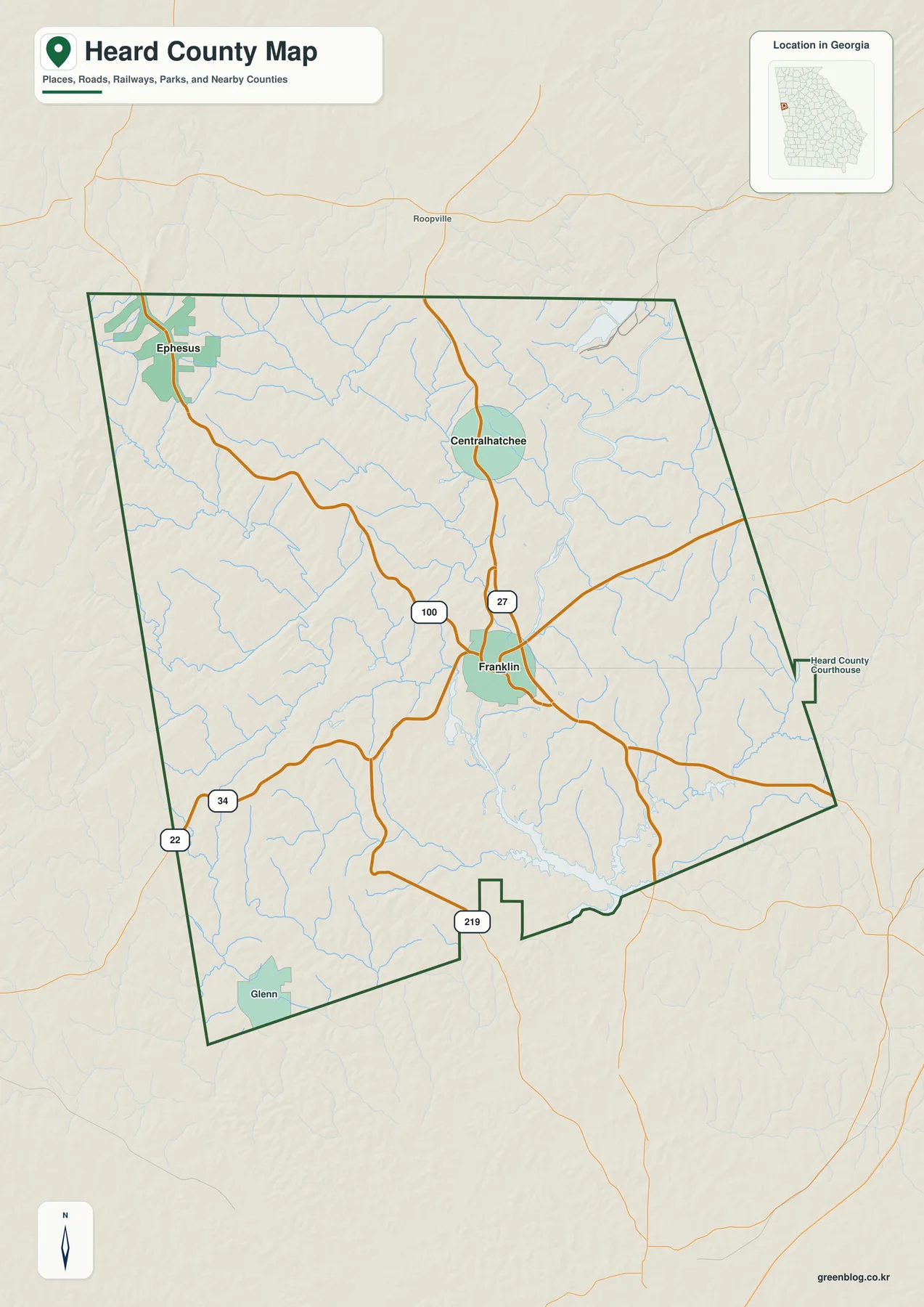
Franklin is the strongest road reference on the general map. Route 27 descends from the Centralhatchee side toward Franklin, while Route 100 provides another major north-south connection through the western-central interior. Routes 34 and 22 are visible toward the southwest, and Route 219 appears close to the southern edge. These routes are useful for county-scale orientation because they establish the main directions in which local travel leaves Franklin. They are not intended to replace current street navigation or show every local road.
Ephesus is the clearest named place in the northwestern corner, close to the Alabama side of the county. Centralhatchee occupies a more central northern position and is easier to relate directly to Franklin through the Route 27 corridor. Glenn appears near the southwestern boundary as a smaller place reference. Roopville is labeled outside the county to the north, adding regional context. Together, these names show a county in which small settlements are separated by large rural areas rather than forming a continuous urban belt.
Thin blue tributaries cover much of the space between the road labels. They are visible west and north of Franklin, around Centralhatchee, below Ephesus, and throughout the eastern half. That detail is important because the open parts of Heard County are not featureless. Short ridges and narrow creek valleys repeatedly divide the landscape. The road map provides the first hint of this terrain, while the dedicated water and elevation views make the relationship between streams and relief much easier to follow.
Straight-Line Connections from Franklin to Centralhatchee and Ephesus
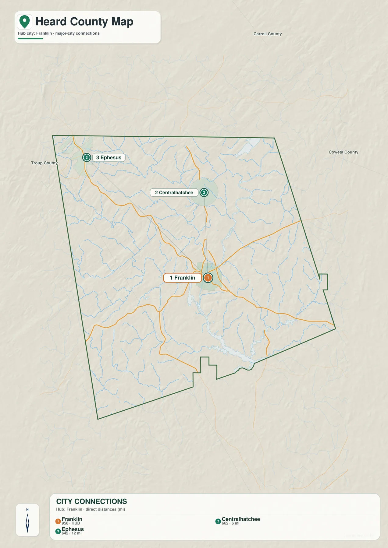
The city-connections map deliberately simplifies the county and uses Franklin as its hub. Its CITY CONNECTIONS panel lists Franklin at 958, Centralhatchee at 662, and Ephesus at 642. These are the values printed on the supplied graphic and are included here to explain the map’s ranking. They should not be treated as newly verified population estimates for this article. Readers who need current official demographic figures can use the Census QuickFacts source in the reference section.
The connector labels place Centralhatchee about 6 miles from Franklin and Ephesus about 12 miles away. Those measurements are straight-line distances, not driving mileage. Actual road travel can be longer because the roads bend through rolling terrain and the exact start and end points vary. The comparison is still useful: Centralhatchee is relatively close to Franklin on the north side, while Ephesus is roughly twice as far away toward the northwestern edge.
Carroll County, Coweta County, and Troup County are labeled outside Heard County for regional orientation. These labels are not survey-grade boundary measurements, but they help show where the Franklin-centered settlement pattern sits within western Georgia. The general map adds Glenn and additional road information, so the city-connections view should be understood as a focused comparison rather than a complete list of every named place in the county.
| Place | Displayed value | Straight-line distance from Franklin | General position |
|---|---|---|---|
| Franklin | 958 | hub | central-southern county |
| Centralhatchee | 662 | about 6 mi | north |
| Ephesus | 642 | about 12 mi | northwest near the state side |
Chattahoochee River, West Point Lake, and the Interior Creeks
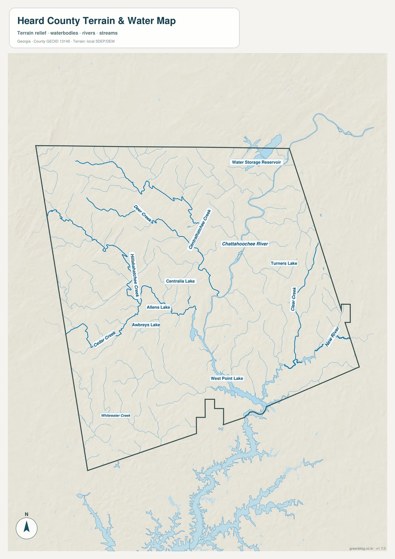
The Chattahoochee River is the strongest large water feature on the map. It follows a winding lower corridor through the eastern and central-southern county, then reaches the broader water of West Point Lake near the southern edge. The difference from the road map is immediate: Franklin remains an important location, but the river and lake become the dominant organizing features in the lower half of Heard County. Long tributary valleys reach toward the Chattahoochee from both sides.
Several named creeks make the northern and western drainage easier to follow. Deer Creek descends from the northwest, while Centralhatchee Creek runs through the central-northern interior toward the larger river system. Clear Creek is a strong eastern reference, and New River is labeled farther southeast. Cedar Creek and Whitewater Creek occupy southwestern valleys. Many smaller unnamed tributaries branch between these waterways, reinforcing the dense drainage pattern already visible on the general county map.
Named standing-water features add local reference points. Centralia Lake appears close to the middle of the county, with Allens Lake and Awbreys Lake nearby to the west and southwest. Turners Lake is labeled on the eastern side near the Clear Creek area, and a Water Storage Reservoir appears close to the northeastern edge. These waters are much smaller than West Point Lake, but they help distinguish locations within an interior where the creek network is otherwise visually similar.
This map is intended for county-scale water orientation. It does not determine parcel flood status, property boundaries, water depth, boating conditions, or legal shoreline access. Those questions require current specialized records. For ordinary map reading, the useful relationships are the Chattahoochee River east of Franklin, West Point Lake along the south, Centralhatchee and Deer Creek in the upper county, and the Clear Creek–New River side farther east.
Elevation from About 191 to 416 Meters
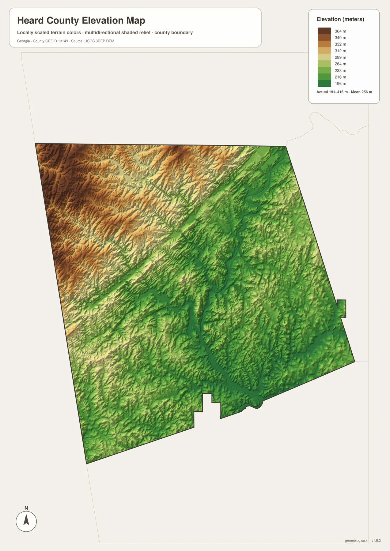
The supplied elevation map reports an actual range of approximately 191 to 416 meters, with a mean of 256 meters. The strongest high relief appears across the west and northwest, where tan and brown ridges form a dense rolling surface. Elevation decreases toward much of the eastern half, and a prominent green valley follows the Chattahoochee River through the central-eastern and southern county. A difference of more than 200 meters between the mapped low and high points is enough to give Heard County a clear ridge-and-valley character.
The river corridor is the easiest place to match water with relief. A dark green band follows the same winding route as the Chattahoochee River and continues toward West Point Lake. The Clear Creek and New River side also contains lower green paths. This relationship makes the drainage network intuitive: water follows the lower routes between hills, and the broadest river occupies one of the deepest continuous corridors on the map.
The western half is higher overall, but it is not a flat upland. Deer Creek, Cedar Creek, Whitewater Creek, and many unnamed tributaries cut narrow green valleys into the brown and tan hills. Ephesus lies closer to this higher northwestern terrain, while Franklin occupies a more intermediate setting between the western ridges and the lower Chattahoochee corridor. The county is therefore better understood as rolling upland repeatedly divided by stream valleys than as a simple one-direction slope.
The elevation colors are designed for broad geographic comparison, not for determining the exact height of a building lot, road project, or drainage design. Site-level work requires finer elevation data and, when appropriate, field measurements. For classroom geography, county profiles, or presentations, the 191–416 meter range clearly shows the higher western uplands and the lower river-and-lake corridor to the east and south.
Franklin, the Chattahoochee, and Heard County’s 1830 Background
The source article in the package states that Heard County was established in 1830 and describes the Chattahoochee River, forestry, agriculture, and travel near the Alabama border as parts of the county’s local context. The four maps here do not measure farm acreage, forest percentage, or traffic volume. Instead, they provide the geography behind those subjects: Franklin as the county seat, Centralhatchee and Ephesus as smaller settlement references, higher rolling ground across the west, the Chattahoochee River corridor through the east and south, and West Point Lake along the lower county edge.
The general county map is the most useful starting point when roads, local places, and the boundary all matter. The Franklin-centered city map gives a cleaner comparison of Centralhatchee and Ephesus and their straight-line spacing. The water map is the better reference for the Chattahoochee River, West Point Lake, creeks, and small lakes, while the elevation map explains why the eastern river corridor lies lower than much of the western upland.
Franklin ties the themes together. Routes 27 and 100 establish the road framework around the county seat, Centralhatchee is shown about 6 straight-line miles to the north, and the Chattahoochee River lies to the east. Farther south, the river widens into West Point Lake, while the northwest rises into stronger ridges toward Ephesus. Reading those relationships together turns Heard County from a list of small place names into a specific landscape shaped by roads, rural settlements, water, and relief.
Frequently Asked Questions
Which place serves as the Heard County seat?
Franklin is the county seat. The general map uses it as the main road and settlement reference, and the city-connections graphic also makes Franklin the hub for Centralhatchee and Ephesus.
Are the 6- and 12-mile labels driving distances?
No. They are straight-line distances from Franklin: about 6 miles to Centralhatchee and about 12 miles to Ephesus. Road mileage can be longer depending on the route and exact endpoints.
Which water features stand out on the county map set?
The Chattahoochee River and West Point Lake provide the largest references. Centralhatchee Creek, Deer Creek, Clear Creek, New River, Cedar Creek, Whitewater Creek, Centralia Lake, Allens Lake, Awbreys Lake, and Turners Lake are also labeled.
What does the A3 download archive contain?
The archive provides four large JPG originals covering the general county reference, Franklin-centered city connections, water features, and elevation. Keeping those themes separate makes roads, place names, water labels, and relief easier to read when printed or placed in a document.
Map File Information
Heard County A3 Map Files
- Included Files: 4 high-resolution A3 JPG map files shown in this article
- File Type: JPG files in a ZIP archive
- Intended Use: Printing, education, presentations, and map-based projects
Related Maps
Heard County Data and Map References
- U.S. Census Bureau QuickFacts: Heard County – current official county statistics
- New Georgia Encyclopedia: Heard County – county history and regional background
- Census TIGER/Line boundary resources – Heard County and neighboring-county reference geometry
- USGS hydrography resources – reference data for the Chattahoochee River, creeks, lakes, and mapped waters
- USGS 3DEP elevation resources – source elevation data for comparing the 191–416 meter terrain range
Green Map creates custom-edited map images using open geographic data sources such as geoBoundaries, Natural Earth, OpenStreetMap, and government open data. These maps are edited visual materials, not raw data files, and are provided for education, documents, presentations, and graphic reference.