This Douglas County Georgia Map focuses on a county immediately west of Atlanta where a strong east–west road network crosses noticeably rolling terrain. Douglasville is the main labeled city, Interstate 20 is the easiest route to trace across the county, and the surrounding maps add waterways and elevation that are easy to miss on a standard road-and-boundary view. Four A3 high-resolution JPG maps can be downloaded together in a ZIP file, so the page can serve both as a quick online reference and as a source for larger printable map files.
The four views are most useful when read as parts of the same place rather than as isolated graphics. The county map places Douglasville, Villa Rica, Lithia Springs, Austell, Fairplay, and major routes in context. The city view strips away much of that detail and keeps attention on Douglasville and the surrounding county framework. The water map brings Sweetwater Creek, Dog River, Mobley Creek, Bear Creek, and a series of small lakes forward, while the elevation map shows a broad change from lower ground along the southeastern side to higher ridges across much of the west and north. Moving between those views makes the county’s geography much easier to understand.
Table of Contents
A county setting between metro Atlanta and western Georgia
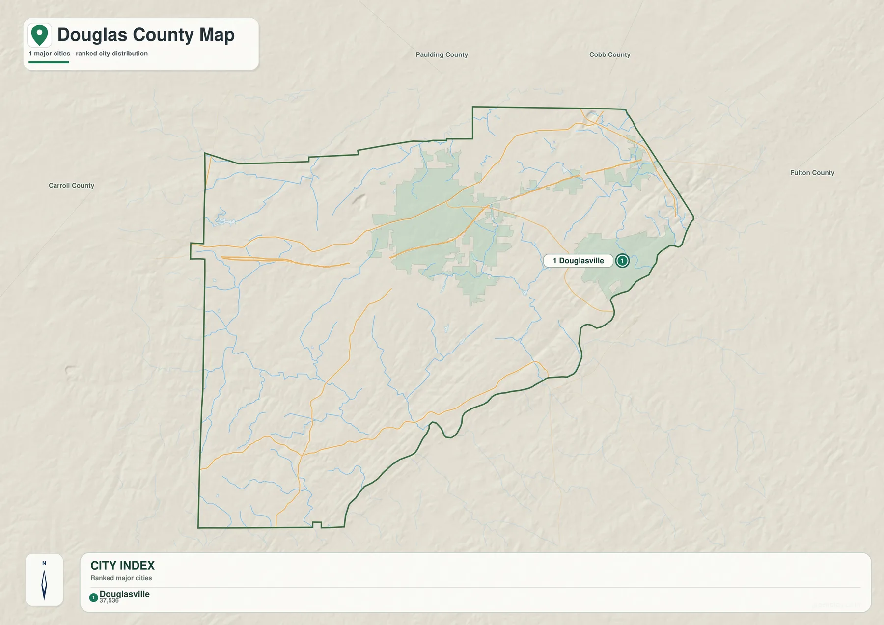
The city map places Douglas County among Paulding County and Cobb County to the north, Fulton County to the east, and Carroll County to the west. That surrounding frame is useful because it shows why the county can feel connected to metropolitan Atlanta while still opening toward a less urban western landscape. South Fulton and Chattahoochee Hills appear beyond the southeastern and southern edges on the broader reference map, while Villa Rica sits near the western side and Austell near the northeastern corner.
The boundary itself is not a simple rectangle. Long straighter segments define much of the north, but the eastern and southeastern edge bends repeatedly before turning across the south. A small western projection appears near Villa Rica, and the southwestern half extends well below the I-20 corridor. This shape matters when reading place labels: a community can look close to Douglasville on a regional map yet lie outside the county, while another place may touch or cross the boundary. The county outline therefore provides the base layer for every other map on the page.
Following I-20 through Douglasville and the northern half of the county
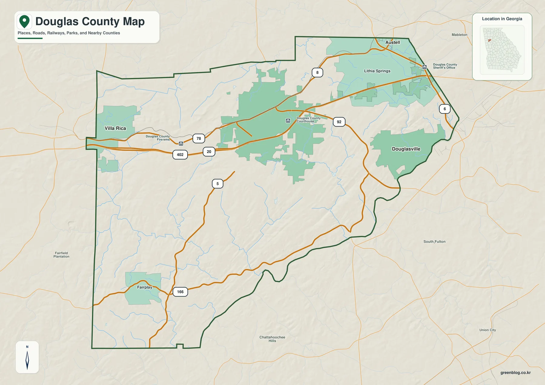
Interstate 20 is the clearest transportation line on the main map. It enters from the west below Villa Rica, crosses the county toward Douglasville, and continues eastward toward the Atlanta side. The map also shows the 402 designation along the interstate. US 78 runs generally east–west farther north and helps connect the Villa Rica side with Douglasville, Lithia Springs, and the northeastern part of the county. Reading those two routes together gives a quick sense of how the most visible settlement labels are arranged across the northern half.
Several state routes add north–south and diagonal connections. Route 5 crosses the central-western part of the county, Route 92 passes near Douglasville and turns through the eastern half, and Route 166 provides an important reference across the south and southwest near Fairplay. Route markers 6 and 8 appear in the northeastern area near Lithia Springs and Austell. These roads should not be treated as a turn-by-turn navigation map, but they are enough to show the basic relationship between the county seat, the western edge, the northeastern communities, and the quieter southern half.
The main map also includes a few public facilities that help anchor the urban area. Douglas County Courthouse appears near the Douglasville road network, the Douglas County Sheriff’s Office is labeled toward the northeast, and a Douglas County Fire/EMS location is shown near the western I-20 side. Those symbols are best used as orientation points rather than as a complete directory of county services. Their value here is that they make the pattern around Douglasville and I-20 easier to recognize at a glance.
Douglasville stands out in the simplified city view
The city map intentionally reduces the number of place labels and identifies Douglasville as the ranked major city. That makes it a cleaner choice when the goal is to show where the county’s principal city sits without filling the page with road numbers and smaller labels. Douglasville appears in the eastern half of the county, not far from the curving southeastern boundary. The surrounding county names remain visible, so the reader can still understand its position relative to Carroll, Paulding, Cobb, and Fulton counties.
This simplified view is especially helpful for presentations, classroom material, or a short county profile. A reader can locate Douglasville first and then switch back to the county map to see I-20, US 78, Route 92, Villa Rica, Lithia Springs, Austell, and Fairplay. The two maps answer different practical questions: one emphasizes the main city within the county shape, while the other explains how that city sits inside the road network. Because only one ranked major city is shown in this preview, there is no need to interpret a city-to-city connector distance here.
The western and northeastern labels are still important even though they do not dominate the city index. Villa Rica provides a useful marker near the Carroll County side, and Austell helps identify the northeastern edge toward Cobb County. Lithia Springs sits southwest of Austell, while Fairplay anchors the southwestern area on the main reference map. Using these labels as orientation points is more reliable than assuming that every named place has the same municipal status or population size.
Sweetwater Creek, Dog River, and a scattered network of smaller waters
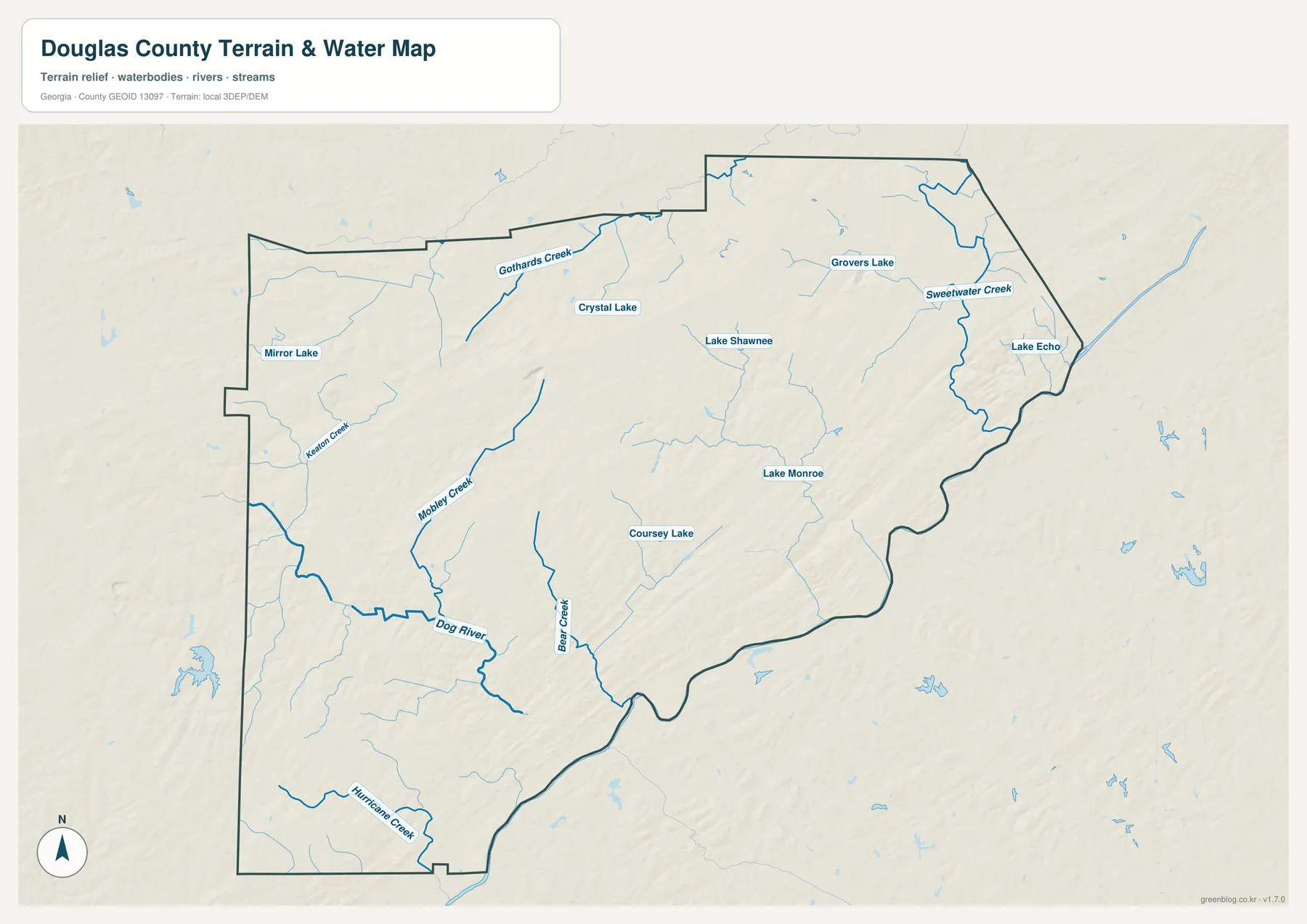
The water map changes the visual emphasis completely. Sweetwater Creek is one of the strongest named features in the northeast, curving southward near the county’s eastern side. Grovers Lake and Lake Echo appear nearby, while Lake Shawnee lies farther west. This part of Douglas County may look primarily urban or transportation-focused on the road map, but the water layer shows that streams and small lakes remain closely interwoven with the developed northeastern section.
Across the west and southwest, the drainage pattern becomes easier to follow through named tributaries. Gothards Creek descends through the northwestern interior. Mobley Creek runs southward through the western half and approaches the Dog River system, which is drawn prominently in the southwest. Hurricane Creek appears near the southern edge. Bear Creek runs through the south-central area, and Coursey Lake and Lake Monroe provide additional reference points to its east. Mirror Lake sits close to the western side, while Crystal Lake is labeled farther north inside the county.
The map is designed for locating water features, not for predicting water hazards. A heavy blue line does not indicate a deeper channel, a higher flood probability, or a legal water boundary. The image does not supply floodplain limits, parcel ownership, dam-safety information, or navigational depth. It is most useful for finding a named creek or lake and then comparing that feature with roads, communities, and terrain on the other maps.
A practical way to read the layer is to start with Sweetwater Creek in the northeast and Dog River in the southwest because both are visually easy to identify. From there, smaller streams such as Mobley Creek and Bear Creek give structure to the interior. The scattered lakes make the drainage network easier to remember because they create fixed points between the larger watercourses. This method avoids treating the water map as a dense list of names and instead turns it into a set of connected geographic reference points.
Elevation shifts from lower southeastern ground to higher western ridges
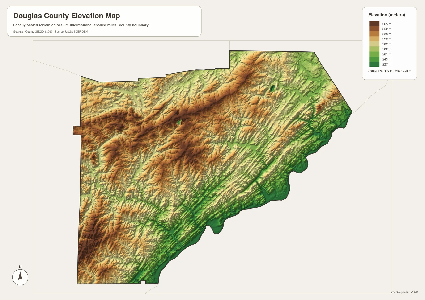
The elevation map gives an actual county range of about 178 to 410 meters and lists a mean elevation of 305 meters. The color pattern makes the broad contrast easy to see. Greens dominate much of the eastern and southeastern edge, indicating lower ground, while yellows, oranges, and browns become more common across the west, northwest, and parts of the north. Long narrow ridges repeat across the interior rather than forming one isolated high point.
The southeastern side is particularly useful for comparison because the lower green belt follows a broad zone near the curving county boundary. When that image is viewed beside the water map, it becomes easier to understand why channels occupy many of the lower corridors. Farther west, the surface becomes more broken, with short ridges and valleys packed closely together. The southwest includes both lower drainage areas and locally higher ground, so the terrain should not be reduced to a simple east-low, west-high rule.
This elevation surface is intended to show county-scale relief. It is not a survey, engineering plan, or parcel-level elevation certificate, and the rendered colors should not be used to estimate the exact height of a house, road, or property corner. For ordinary map reading, however, it is very effective: the map quickly identifies where relief is stronger, where lower terrain spreads along the southeast, and how the county’s ridges run through areas that may look comparatively plain on the standard reference map.
The range also adds context to the roads. I-20 crosses a landscape that changes repeatedly rather than staying on one flat surface, while the southern routes pass through alternating low corridors and rolling ground. The purpose is not to infer road grade from the map, but to understand that transportation, settlement, and waterways occupy a county with meaningful topographic variation. That broader context is one reason the elevation view is worth keeping alongside the county and water maps.
What becomes clearer when the four views are compared
The standard county map naturally draws attention to roads and labeled places, so it can create the impression that Douglas County is mainly an I-20 suburban corridor. The other layers add important depth to that first impression. The city map shows how strongly Douglasville functions as the central reference point in this set. The water map reveals that the county contains a wide network of creeks and lakes, including prominent systems in both the northeast and southwest. The elevation map then explains why those waters do not cross a uniform plain: ridges and lower valleys repeat throughout much of the county.
One useful reading sequence begins at Douglasville, follows I-20 west toward Villa Rica, and then switches to the water layer to notice features that are less obvious on the road map. Mobley Creek and Dog River give the western and southwestern side a different geographic character from the Sweetwater Creek area in the northeast. Moving to the elevation layer shows that both sides contain relief, but the highest and most strongly colored ridge country is concentrated more heavily across the western and northern interior. That progression turns a simple location exercise into a clearer picture of the county’s physical setting.
The maps can also be separated when only one question matters. A county boundary reference does not need every creek label. A water discussion does not need public-facility symbols. A terrain lesson does not need to imply that color bands are municipal divisions. Choosing the map that fits the question keeps the explanation simple, while having all four available on the same page makes it easy to verify how the different layers relate to one another.
Choosing the most useful Douglas County map for a project
For a general county profile, begin with the reference map because it combines the boundary, major roads, and several recognizable place labels. If a slide or worksheet needs a cleaner city-centered graphic, the Douglasville city view removes much of the visual clutter. The water map is the better choice when Sweetwater Creek, Dog River, or named lakes are part of the topic. The elevation map works best when the discussion is about relief, ridges, lower corridors, or the county’s 178–410 meter range rather than street-level navigation.
- Boundary and transportation: use the county map to connect Douglasville, Villa Rica, Austell, I-20, US 78, and the main state routes.
- Simple city orientation: use the city map when Douglasville’s position within Douglas County and the surrounding counties is the main point.
- Streams and lakes: use the water map to locate Sweetwater Creek, Dog River, Mobley Creek, Bear Creek, and the named lakes shown in the county.
- Terrain comparison: use the elevation map to compare the lower southeast with the more strongly ridged west and north.
The downloadable set keeps the four subjects separate instead of forcing every label onto a single image. That makes the files easier to reuse in different contexts, from a county overview to a focused discussion of waterways or terrain. The JPG originals are sized for A3 output, while the page previews are optimized for viewing in the article. When printing, scaling, or inserting a map into a document, the downloadable JPG is the more appropriate source file.
Frequently Asked Questions
Where does I-20 pass through Douglas County?
I-20 crosses the northern half of the county from the Villa Rica side toward Douglasville and then continues east toward the Atlanta side. It is the easiest east–west transportation line to follow on the county reference map, especially when compared with US 78 farther north.
Does the water map identify flood-risk areas?
No. It identifies named streams, rivers, and lakes for geographic reference. Flood zones, expected inundation, channel depth, parcel boundaries, and engineering conditions require separate official hazard or survey data.
What is the main elevation contrast shown in the county?
The map gives an overall range of about 178 to 410 meters. Lower terrain is most visible along much of the eastern and southeastern side, while higher and more closely spaced ridges appear across large parts of the west, northwest, and north. The map is intended for broad comparison, not site-specific elevation measurement.
Map File Information
Douglas County A3 map files
- Included Files: Four high-resolution A3 JPG maps
- File Type: ZIP archive containing JPG images
- Intended Use: Printing, education, presentations, and map-based projects
Related Maps
Sources and reference data
The following official resources provide county information or the underlying types of boundary, hydrography, and elevation data used for geographic reference.
- Douglas County official overview
- U.S. Census Bureau QuickFacts for Douglas County
- U.S. Census Bureau TIGER/Line Shapefiles
- USGS National Hydrography
- USGS 3D Elevation Program
Green Map creates custom-edited map images using open geographic data sources such as geoBoundaries, Natural Earth, OpenStreetMap, and government open data. These maps are edited visual materials, not raw data files, and are provided for education, documents, presentations, and graphic reference.