Download the Tallapoosa County Map as one ZIP containing four original A3 high-resolution JPGs: a county-and-roads map, a six-place ranked map, a terrain-and-water map, and an elevation map. The county is easiest to understand by comparing Alexander City on the northwest side of Lake Martin with Dadeville near the central part of the county. Camp Hill points toward the eastern side, New Site and Daviston toward the north, and the Tallapoosa River ties those areas to a water system that changes from narrow river valleys to the broad, branching reservoir.
Tallapoosa County occupies east-central Alabama and borders Clay and Randolph counties on the north, Chambers and Lee on the east, Macon and Elmore on the south, and Coosa on the west. The general map includes a much wider set of labels than the ranked-city graphic, including Jackson’s Gap, Hackneyville, Goldville, Our Town, Reeltown, and Tallassee near the southern edge. That broad context matters because this is not a county where every community belongs to one continuous urban strip; roads, water, and rolling uplands separate several local centers.
Table of Contents
Alexander City, Dadeville, and the county’s lake-centered layout
Alexander City and Dadeville provide the clearest first orientation. Alexander City lies in the northwest beside the northern arms of Lake Martin and is the largest place represented on the ranked city map. Dadeville sits farther east and serves as the county seat. Jackson’s Gap occupies the area between them on the north side of the reservoir, while Camp Hill stands farther east toward the Chambers and Lee County side. The difference between those locations becomes much easier to understand when the lake is treated as a major geographic feature rather than as background decoration.
| State | Alabama |
|---|---|
| County | Tallapoosa County |
| County seat | Dadeville |
| Largest ranked place | Alexander City |
| 2025 population estimate | 40,953 |
| 2020 census population | 41,311 |
| Land area | 716.53 sq mi |
| Main road references | U.S. 280, Alabama 49, plus routes 22, 38, 50, 63, 120, and 259 shown on the map |
| Water references | Lake Martin, Tallapoosa River, and a dense network of creeks and small lakes |
| Elevation shown | Actual 49-355 m, mean 191 m |
The supplied demographic material gives a July 1, 2025 population estimate of 40,953, compared with 41,311 in the 2020 Census, and a land area of 716.53 square miles. Those numbers help explain why the county map contains substantial rural space between its named communities. They should be read as background rather than as a mapped population layer: the purpose of the county image is to show where communities, routes, streams, and the county boundary sit in relation to one another.
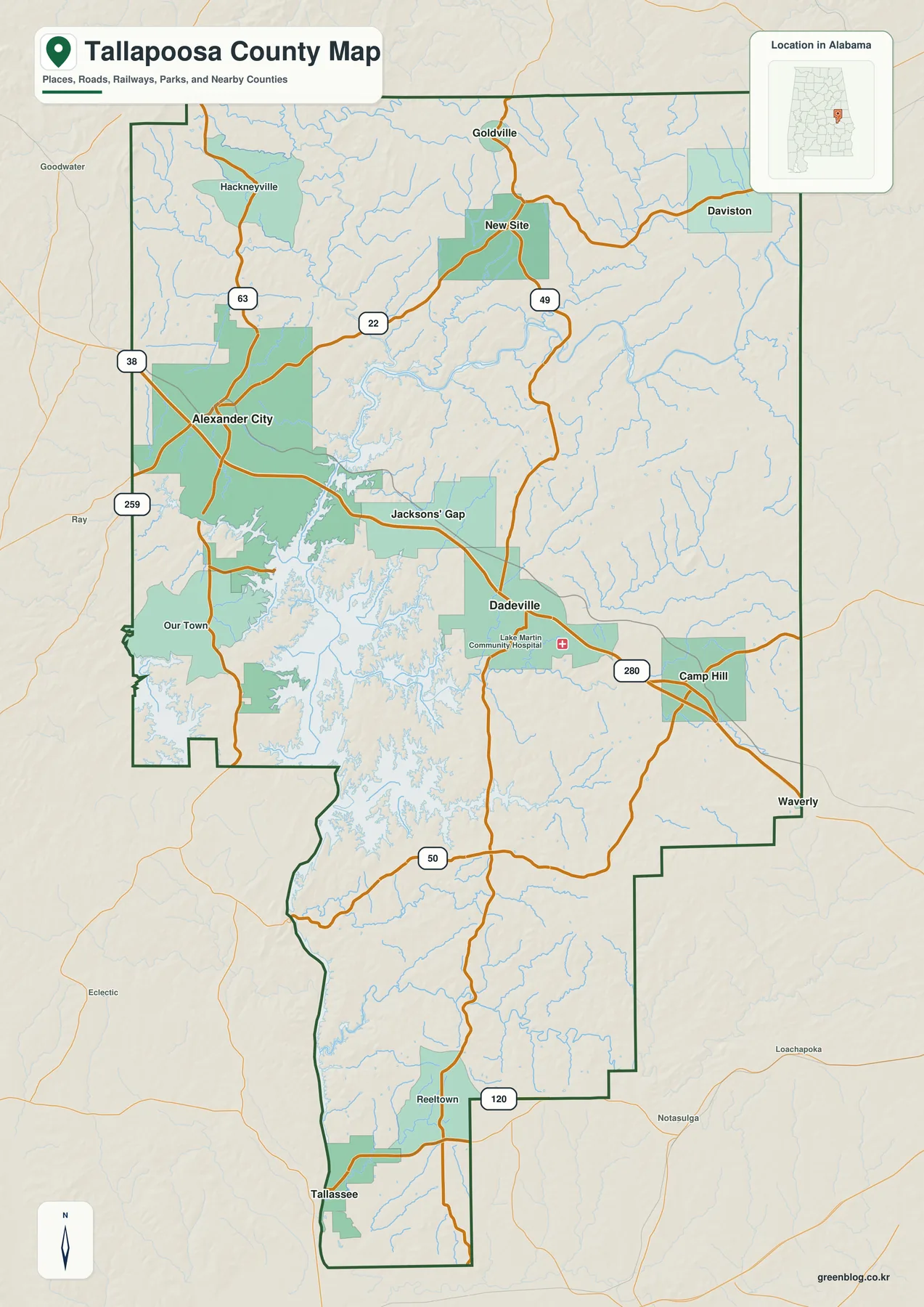
U.S. 280 supplies the clearest east-west road reference. It passes through Alexander City, continues toward Dadeville, and then reaches the Camp Hill side, linking three of the most prominent places on the map. Alabama 49 is more useful for north-south orientation through Dadeville, extending toward New Site and the northern Tallapoosa River country in one direction and toward the Lake Martin area in the other. Routes 22 and 63 add connections around Alexander City and the northwestern interior, while 50 and 120 help locate the southern part of the county.
Six ranked places reveal a large northwest center and smaller regional towns
The ranked city map selects six places from the wider set of labels. Alexander City is printed at 14,606, well ahead of Dadeville at 2,993. Camp Hill follows at 1,238, Jackson’s Gap at 786, New Site at 750, and Daviston at 193. These are the values printed on the supplied graphic, so they are most useful for comparing the map’s selected places rather than replacing a separately dated population table.
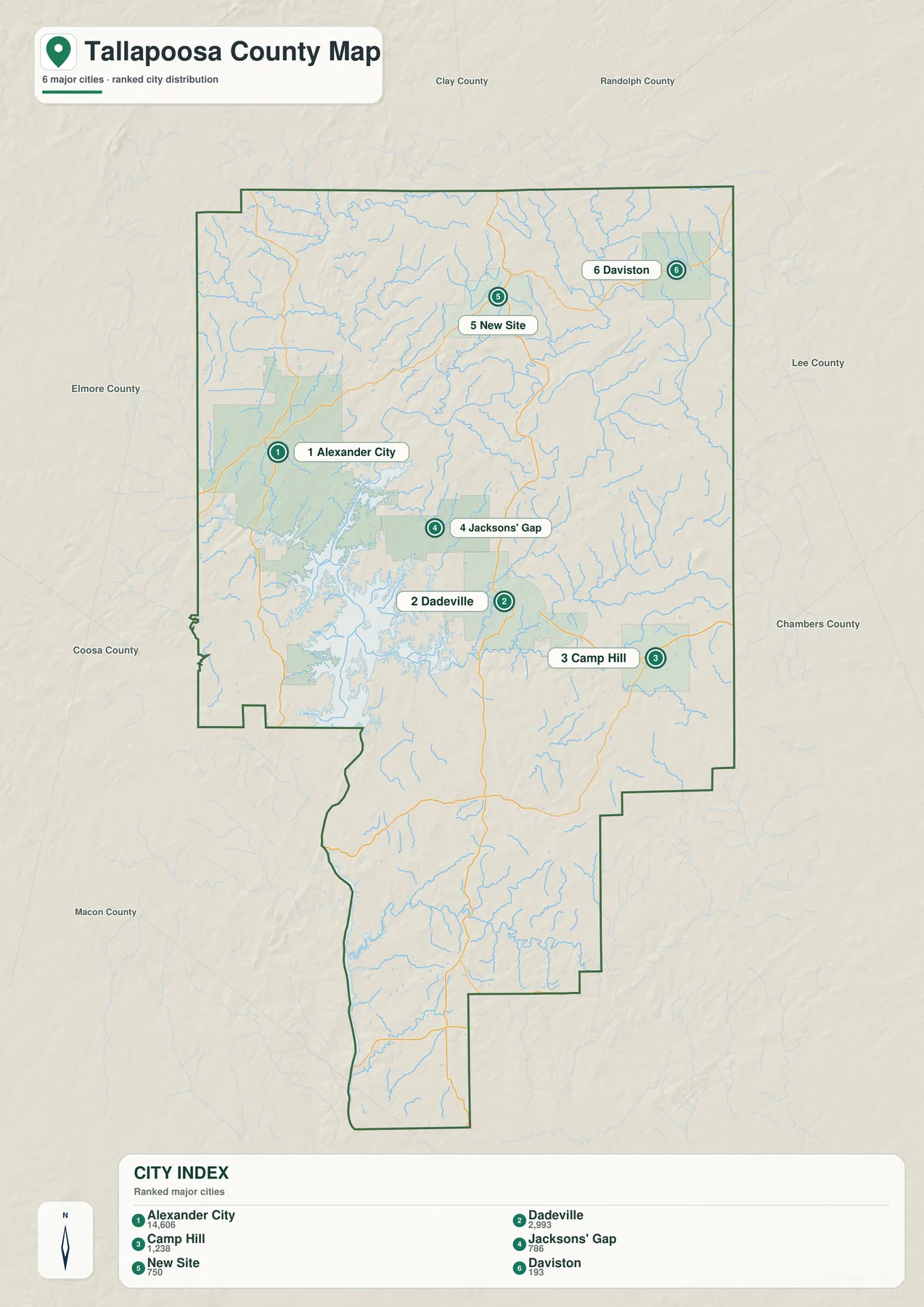
The geography behind the ranking is more useful than the numbers alone. Alexander City anchors the northwest and has a direct relationship with U.S. 280 and Lake Martin. Dadeville provides the administrative reference closer to the center. Camp Hill lies much farther east, while Jackson’s Gap sits on the lake-and-road corridor between the two leading places. New Site and Daviston are northern references where the water network narrows into river and creek valleys.
The city graphic is deliberately selective. The general county map also labels Hackneyville, Goldville, Our Town, Reeltown, and other communities that are not included in the six-place ranking. For that reason, the ranked map should be used to compare a small set of prominent places, while the general map is better for a broader inventory of local names, roads, and county-edge context.
Lake Martin changes the county from river valleys to a branching reservoir landscape
Lake Martin is the county’s most visually dominant water feature. The existing source material describes the reservoir as having been created by Martin Dam on the Tallapoosa River, covering about 40,000 acres at full pool and having more than 700 miles of shoreline. The map makes the reason for that long shoreline obvious: the water does not form a simple oval. It fills former valleys and tributary arms, producing long coves and narrow peninsulas between Alexander City, Jackson’s Gap, Dadeville, and the western county boundary.
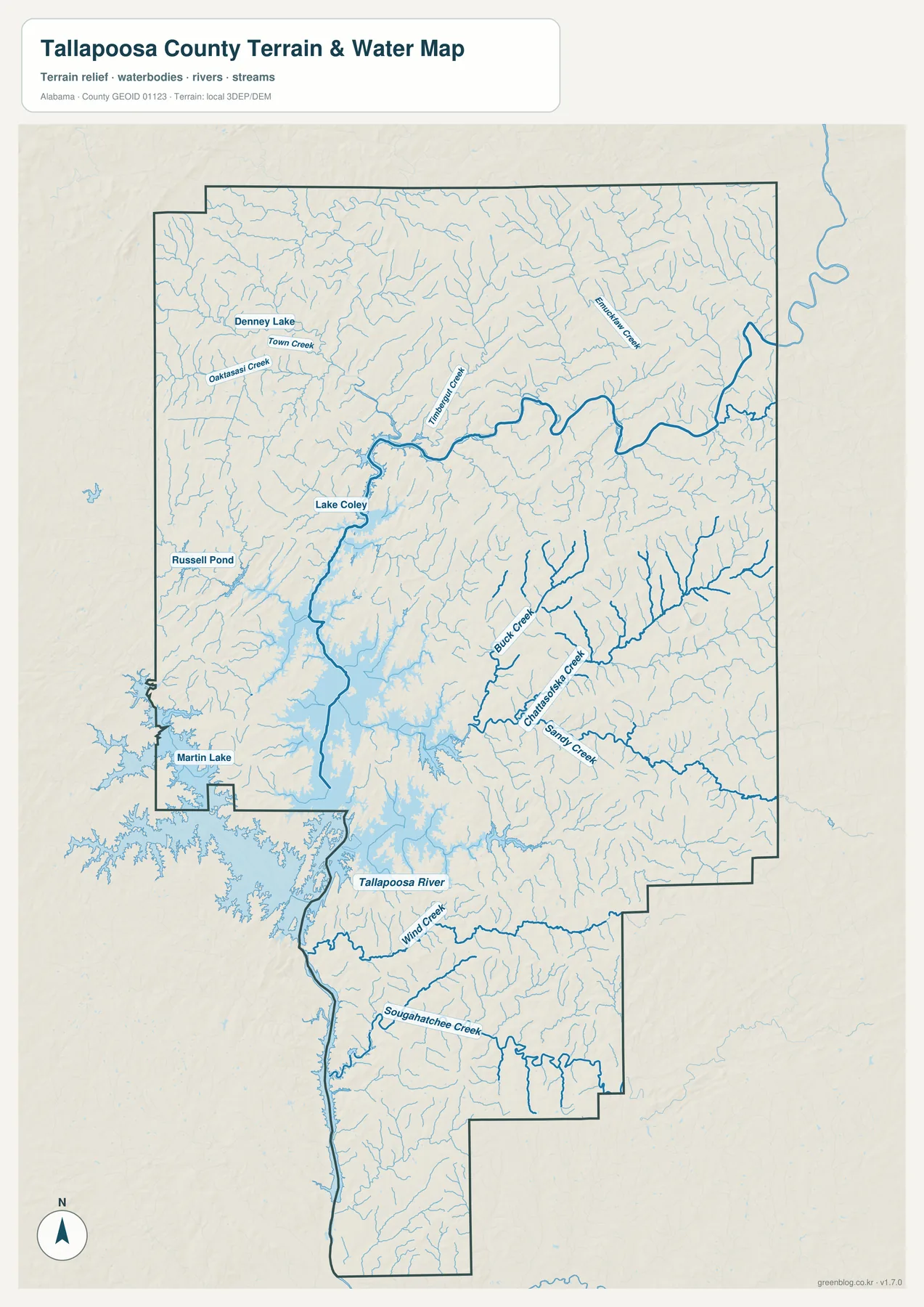
The dedicated water map is much more detailed than the county overview. Denney Lake and Town Creek appear in the northwest, with Lake Coley and Russell Pond providing additional small-water references. Buck Creek and Sandy Creek are easy to pick out in the central-eastern drainage, while Wynn Creek and Sougahatchee Creek cross the southern half toward the Tallapoosa River. Numerous thinner tributaries fill the space between those named features, showing that the county’s water system is dense even away from Lake Martin.
The water landscape changes from north to south. North of the reservoir, the Tallapoosa River and its tributaries occupy comparatively narrow valleys and large bends. Around Lake Martin, those valleys broaden into a complex reservoir shoreline. Farther south, the Tallapoosa River becomes the main linear water reference again as it continues down the western side of the county. The map is well suited to geographic orientation, but it should not be treated as a flood map, legal water-boundary record, navigation chart, or parcel drainage study.
Horseshoe Bend connects northern river geography with county history
Horseshoe Bend National Military Park adds useful context to the northern Tallapoosa River. The supplied background explains that the park preserves a large horseshoe-shaped river meander and the site of the 1814 Battle of Horseshoe Bend. The physical form of the river is therefore part of the place’s name and history, not merely a nearby natural feature. For map readers, it is a good reminder that the northern county is defined by winding river valleys before the water reaches the much broader Lake Martin system.
New Site and Daviston are useful local references for this northern part of the county. Their position on the ranked map separates them from the Alexander City-Dadeville-Lake Martin cluster to the south and west. Even without a large park label on the general county map, the dense northern drainage and the course of the Tallapoosa River provide the physical setting needed to understand why Horseshoe Bend belongs to this part of the county.
Elevation rises into northern and eastern hills above the lake and southern river country
The elevation map reports an actual county range from 49 to 355 meters and a mean of 191 meters. The strongest brown high ground appears across much of the north and northeast, with additional ridges and rolling uplands extending through the central-east. Lower green terrain becomes much more common around Lake Martin, across the southwestern interior, and along the Tallapoosa River as it continues south.
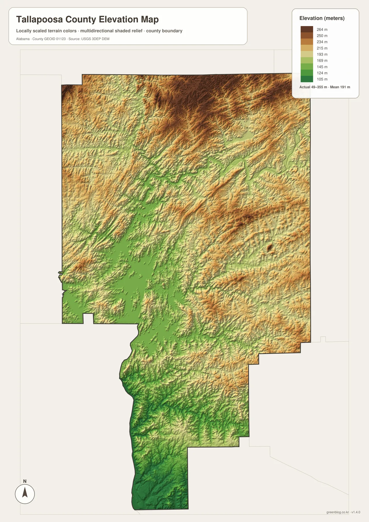
The existing county background places Tallapoosa County within Alabama’s Piedmont Upland. That description fits the relief image: the landscape is made of repeated hills, ridges, and narrow stream valleys rather than one isolated mountain wall. North of Alexander City and across the eastern half, the terrain becomes more broken. Around the reservoir, drowned valleys and lower ridges create the irregular shoreline that is so prominent on the water map.
Relief also adds useful context to transportation. U.S. 280 and Alabama 49 do not cross a perfectly flat surface; their curves and changes in direction occur within rolling hill country and around the lake. Comparing the general map with the elevation layer helps explain why two places that appear close in straight-line distance may have a less direct road connection. The elevation image is intended for county-scale comparison and should not be used as survey-grade or engineering-grade measurement for a specific property.
U.S. 280 and Alabama 49 provide the simplest travel framework
For practical orientation, U.S. 280 is the easiest line to follow first. It links Alexander City, Dadeville, and the Camp Hill direction across the county, creating a recognizable west-to-east corridor. Alexander City faces Coosa County and points farther west, while Camp Hill provides a reference toward Chambers and Lee counties. This route also helps explain why the three highest-ranked places on the city map form a broadly similar east-west sequence despite their different local roles.
Alabama 49 supplies the complementary north-south relationship through Dadeville. Following it north leads toward New Site and the Tallapoosa River/Horseshoe Bend part of the county; following it south returns to the Lake Martin area. Jackson’s Gap sits between Alexander City and Dadeville near the reservoir, while Daviston remains a smaller northern reference in much hillier country. Those road-and-place relationships are usually more useful for a visitor than trying to memorize every smaller route number printed on the county map.
Choose a Tallapoosa County map according to the detail you need
Use the general county map when you need boundaries, roads, major communities, and Lake Martin together in one view. It works well for locating Alexander City and Dadeville, following U.S. 280, or placing Camp Hill, New Site, Daviston, and the southern communities within the full county outline. The ranked city map is cleaner when the only question is how the six selected places compare and where they sit relative to one another.
Choose the water map when named creeks, small lakes, and the transition from Tallapoosa River to Lake Martin are the main subject. It shows far more local water detail than the county map. Choose the elevation map when the question is terrain: the north and northeast rise into noticeably higher hills, while the reservoir and southern river country occupy lower ground.
For classroom use, printing, local research, or a personal map project, the four files work well together because they separate information instead of crowding every label onto one image. Start with roads and place names, use the ranked map to simplify the settlement pattern, then add water and elevation when the physical landscape becomes important.
Frequently Asked Questions
Which place is the county seat, Dadeville or Alexander City?
Dadeville is the county seat. Alexander City is much larger on the supplied ranked map and is the major northwest urban center near Lake Martin, but county-government and population roles are not the same thing. The general map makes that distinction easier to see because both places appear in relation to the reservoir and U.S. 280.
Is all of Lake Martin inside Tallapoosa County?
No. The general map shows the reservoir extending beyond the Tallapoosa County boundary into neighboring areas. The maps on this page focus on the portion relevant to Tallapoosa County and the way it separates or connects local communities.
Where is the highest terrain shown in Tallapoosa County?
The elevation map places much of the highest terrain in the north and northeast. Its actual range is 49 to 355 meters with a mean of 191 meters. Lower terrain becomes more widespread around Lake Martin and along the Tallapoosa River toward the south.
Map File Information
Tallapoosa County map files
- Included Versions: county, city, water, elevation
Related Maps
- Abbeville, Headland, and Lake Eufaula on the Henry County Alabama Map
- Athens to Wheeler Reservoir on the Limestone County Alabama Map
- Autauga County Map
Sources and references
- U.S. Census Bureau — population and land-area background
- Tallapoosa County official website — county government and local information
- National Park Service — Horseshoe Bend National Military Park — northern Tallapoosa River and historic-site context
- USGS National Hydrography — water-feature reference
- USGS 3D Elevation Program — elevation reference
Green Map creates custom-edited map images using open geographic data sources such as geoBoundaries, Natural Earth, OpenStreetMap, and government open data. These maps are edited visual materials, not raw data files, and are provided for education, documents, presentations, and graphic reference.