Download the Mobile County Map as one ZIP containing four high-resolution A3 JPG files: a county reference map, major-city map, water map, and elevation map. The page also explains how Mobile, Mobile Bay, Dauphin Island, the inland west, and the Gulf coast fit together, so the downloadable files are useful for printing, classroom work, route orientation, and general geographic reference.
The main geographic contrast is between the Mobile urban area near the bay, the inland west and northwest, and the lower coastal section that ends at Dauphin Island. Mobile, Prichard, Chickasaw, Saraland, and Satsuma form the strongest cluster of labeled cities. Farther south, Grand Bay and Bayou La Batre face a very different landscape of tidal water and Gulf access, while the barrier island lies beyond the mainland road network.
Table of Contents
A County Shaped by Mobile Bay
The county reference map gives the broadest orientation. Mobile sits near the eastern side of the county at the head of Mobile Bay, with Prichard, Chickasaw, Saraland, and Satsuma continuing northward. Semmes lies west of that urban concentration, while Citronelle and Mount Vernon are much farther north. The southern half stretches past Tillmans Corner toward Grand Bay, Bayou La Batre, and finally Dauphin Island.
This layout is useful because straight-line distance can be misleading in a coastal county. Mobile Bay and the river system occupy much of the eastern edge, and the lower county contains many creeks, bays, and wet areas. A place that looks close across the water may require a much longer road trip, while communities along I-65 or I-10 can be more directly connected even when they are farther apart on the page.
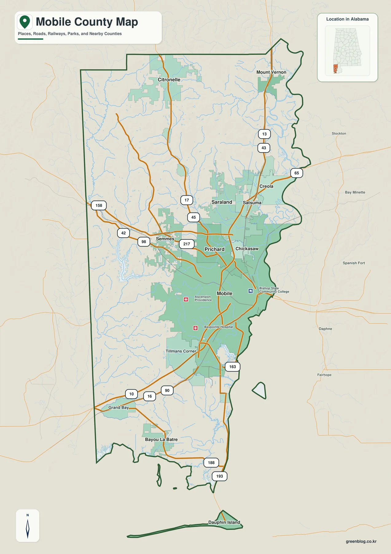
The road pattern reinforces those differences. I-65 runs north from Mobile through the main urban corridor, while I-10 provides the major east-west connection across the Gulf Coast region. Other highways shown on the map branch toward the western interior, the northern part of the county, and the lower coastal communities. Alabama 193 is especially easy to recognize because it provides the final mainland connection to Dauphin Island.
Cities Cluster Near the Mobile Urban Core
The city map reduces the amount of detail and ranks six major places: Mobile, Prichard, Saraland, Satsuma, Chickasaw, and Semmes. Mobile is clearly the dominant southern point in this group. Prichard and Chickasaw sit immediately north of it, Saraland and Satsuma continue farther up the eastern side, and Semmes is separated to the west. The result is a simple view of where the county’s main urban concentration actually lies.
That eastern concentration matters when the county is compared with its full boundary. The populated core occupies only part of a much larger area. Northern and western communities are more widely spaced, and the lower coastal section extends a long distance beyond the six-city cluster. For classroom use or a quick location comparison, the city map makes this pattern clearer than a map with every road and small place label.
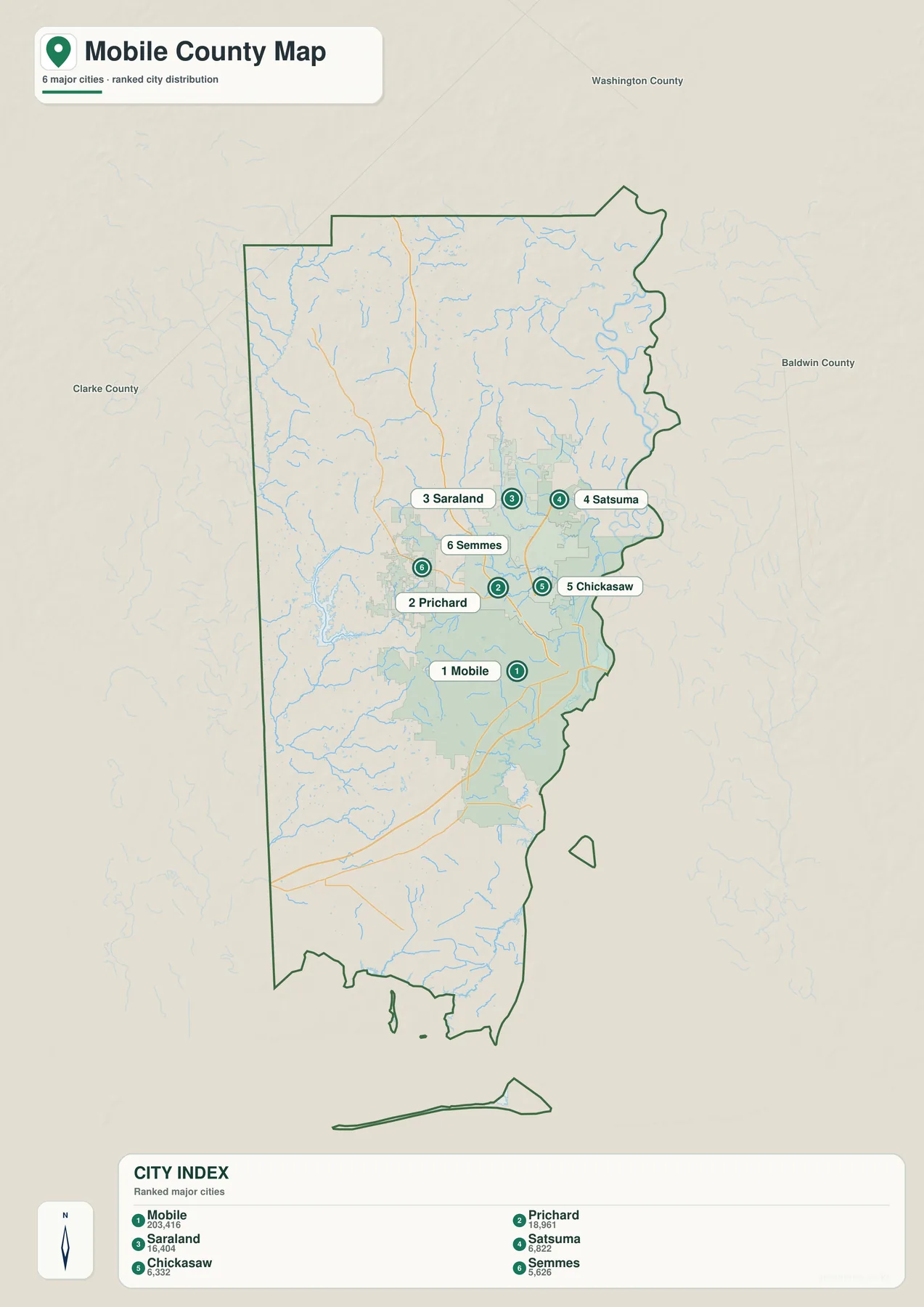
The general map is still better when you need places outside the ranked six. Creola and Mount Vernon help orient the north; Citronelle marks the inland northwest; Tillmans Corner is useful on the southwest side of the Mobile urban area; and Grand Bay, Bayou La Batre, and Dauphin Island define the lower county. Switching between the two views lets you keep the city hierarchy simple without losing the wider geographic frame.
For route planning, start at Mobile and follow the main road corridors outward. The I-65 direction leads toward Prichard, Saraland, and Satsuma. The southwest side connects toward Tillmans Corner and Grand Bay, while the southern coastal route continues toward the Dauphin Island Parkway and Alabama 193. This approach is much easier than trying to memorize a long list of place names without a directional anchor.
Rivers, Bays, and the Coastal Edge
Water is not a background detail in Mobile County; it defines a large part of the county’s eastern and southern geography. The water map labels Mobile River and Spanish River near the upper bay, Dog River farther south, and the Fowl River system closer to the lower coast. Escatawpa River appears along the western side, while many smaller tributaries spread across the interior.
Mobile Bay occupies the large open-water area east of the county and connects southward toward Mississippi Sound and the Gulf of Mexico. Point Aux Chenes Bay is labeled near the southwest coast, and the map also shows the relationship of the county to Weeks Bay and Bon Secour Bay across the broader bay system. These labels make the coast much easier to understand than a simple county outline can.
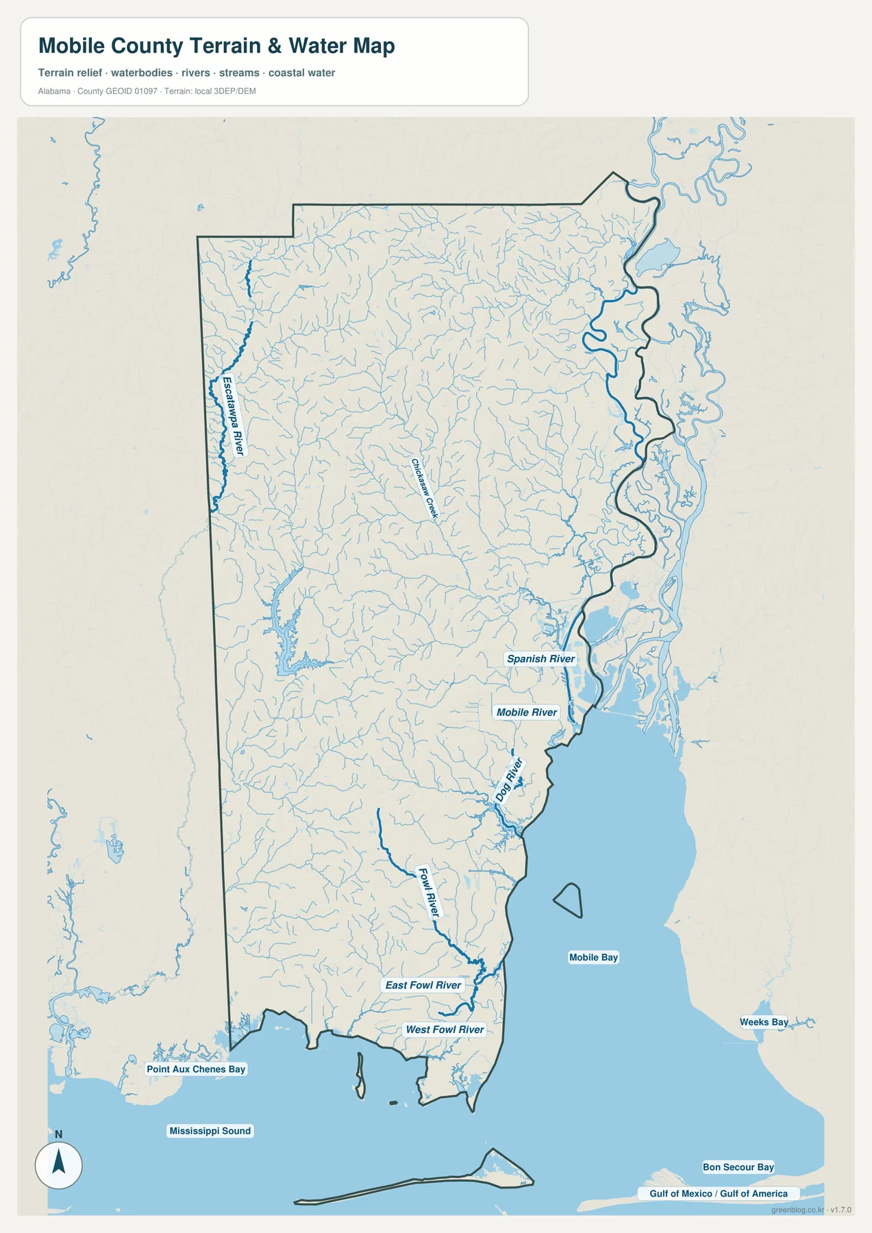
The Mobile urban area sits on the west side of the Mobile River rather than in the middle of a continuous land surface. East of downtown, broad water and wetlands interrupt the normal street grid, so crossings toward Baldwin County are concentrated on major bridge and causeway routes. The map therefore helps explain why the county’s eastern edge looks open and lightly labeled even though it is directly beside a large metropolitan area.
The same principle becomes more obvious in the south. Dog River and the Fowl River branches divide the lower mainland, and Bayou La Batre is tied to a coastal setting very different from inland Semmes or Citronelle. Dauphin Island is another step removed: it sits at the mouth of Mobile Bay as a barrier island and is reached from the mainland by Alabama 193. Grouping all of these places as simply “south Mobile County” hides meaningful differences in access and physical setting.
Elevation from Inland Ridges to the Gulf
The elevation map shows a clear transition from higher inland ground to low coastal terrain. The map reports an actual range of about -1 to 106 meters, with a mean elevation near 34 meters. Browns and tan shades are concentrated in the west and northwest, where small ridges and valleys create a rougher surface. Greens dominate much of the eastern side and lower county closer to the river, bay, and Gulf.
Mobile County is not a mountain county, but the shaded relief makes the inland terrain much more visible than it is on the road map. Western and northwestern drainage lines cut through rolling ground, while the eastern side becomes lower and smoother as it approaches the Mobile River system. The southern mainland and Dauphin Island also remain close to sea level compared with the inland ridges.
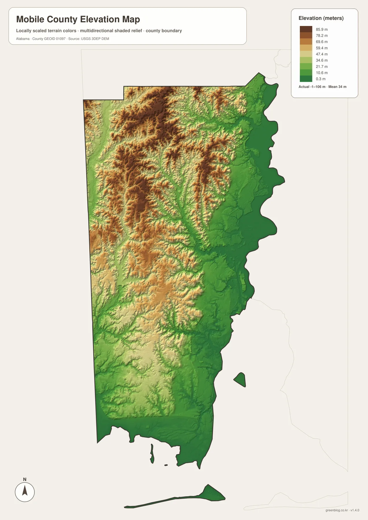
Using the elevation and water maps together gives a more complete picture. Rivers and small tributaries descend from the inland surface toward the low eastern and southern waters, while the broad bay and coastal edge occupy the lowest part of the county. This is useful for geography lessons, general terrain comparison, and understanding why the county’s landscape changes so much between Citronelle, Mobile, Bayou La Batre, and Dauphin Island.
The elevation colors should not be treated as a property-level flood map or a statement about development rules. They show relative height and shaded terrain at county scale. If a specific parcel, flood zone, navigation route, or regulated area matters, a dedicated official dataset should be checked separately.
Choosing the Right Map for the Task
Use the county reference map when you need the most complete orientation. It combines the boundary, many place labels, major roads, and the county’s position within Alabama. It is the best choice for a general report, a travel overview, or a worksheet where readers need to connect Mobile with northern, western, and coastal communities.
Use the city map when the goal is simpler. Its ranked markers make Mobile, Prichard, Saraland, Satsuma, Chickasaw, and Semmes easy to compare without competing road labels. Choose the water map for river and bay names, especially Mobile River, Spanish River, Dog River, the Fowl River branches, Mobile Bay, and the Gulf edge. The elevation map is the clearest choice for comparing the higher western interior with the low eastern and southern coastal plain.
- County map: boundary, roads, many labeled places, and overall orientation
- City map: quick comparison of the six ranked major cities
- Water map: rivers, tributaries, Mobile Bay, Mississippi Sound, and the Gulf coast
- Elevation map: county-scale terrain from roughly -1 to 106 meters
The WebP images on this page are convenient for reading on screen, but the downloadable set is prepared for larger use. The ZIP keeps the four map themes as separate A3 JPG files, so you can print one map, place several side by side, or use the water and elevation versions as companions to the general county map. There is no need to extract information from a small screenshot when the full-size files are available below.
Frequently Asked Questions
Which map is best for understanding Dauphin Island and the lower coast?
Start with the water map because it shows Mobile Bay, the Gulf edge, the Fowl River system, and the separation between the mainland and Dauphin Island. Then use the county map to trace the road connection south from Mobile and identify Alabama 193. Together, the two maps show both the physical coast and the practical land route to the island.
Why does the elevation map look so different from the city map?
The city map is designed to simplify settlement patterns, so it highlights six major places and keeps other details quiet. The elevation map removes that city emphasis and uses terrain shading to show higher inland ridges and lower land toward Mobile Bay and the Gulf. They answer different geographic questions and are most useful when viewed as companion maps rather than substitutes for one another.
Map File Information
Mobile County A3 map files
- Included Versions: county, cities, water, elevation
Related Maps
- Abbeville, Headland, and Lake Eufaula on the Henry County Alabama Map
- Athens to Wheeler Reservoir on the Limestone County Alabama Map
- Autauga County Map
Sources and Reference Data
The maps and local descriptions can be checked against the following official sources. These links cover county background, road classification, the Port of Mobile, Dauphin Island, national hydrography, and elevation data.
- Mobile County official history and municipal information
- ALDOT Highway Functional Classification Maps
- Alabama Port Authority: Port of Mobile
- Town of Dauphin Island official information
- USGS National Hydrography
- USGS 3D Elevation Program
Green Map creates custom-edited map images using open geographic data sources such as geoBoundaries, Natural Earth, OpenStreetMap, and government open data. These maps are edited visual materials, not raw data files, and are provided for education, documents, presentations, and graphic reference.