The Lamar County Alabama Map is easiest to understand by starting with Vernon near the middle of the county and then looking west toward the Mississippi state line. Sulligent sits in the northern part of the county along U.S. 278, while Millport and Kennedy help define the south and Beaverton and Detroit mark the northeastern side. Because the county is rural and crossed by many creeks and low ridges, roads, waterways, and terrain are more useful orientation clues than city size alone.
You can download the map set from this page as a ZIP containing four high-resolution A3 JPG files. The files cover the main county map, the distribution of six incorporated places, the water network, and elevation. The sections below explain what each map is best for, so you can check the preview first and then choose the printable file that fits a classroom project, trip planning reference, local-history study, or general geographic comparison.
Table of Contents
A County on Alabama’s Western Edge
| State | Alabama |
|---|---|
| County | Lamar County |
| County seat | Vernon |
| 2025 population estimate | 13,587 |
| 2020 census population | 13,972 |
| Land area | 604.85 square miles |
| Main roads | U.S. 278, AL 17, AL 18, and AL 96 |
| Major water systems | Buttahatchee River and Luxapallila Creek systems |
Lamar County occupies the northwestern edge of Alabama. Mississippi is directly to the west, Marion County is to the north, Fayette County is to the east, and Pickens County is to the south. That state-line position matters when reading the map because highways and streams continue across the boundary; the western edge is not an isolated wall around the county.
The county is large in area compared with its population. The supplied reference material lists 13,972 residents in the 2020 census and a July 1, 2025 estimate of 13,587. Instead of one dominant urban center filling the map, Lamar County has a series of small towns separated by broad rural areas, wooded ridges, creek valleys, and local roads.
For a first pass, find Vernon and use it as the central reference point. From there, Sulligent is north and west toward Mississippi, Millport and Kennedy are far to the south, and Beaverton and Detroit are in the northeastern part of the county. Once those places are fixed in your mind, it becomes much easier to compare the road, water, and elevation maps without losing your orientation.
County Boundary, Vernon, and the Main Road Pattern
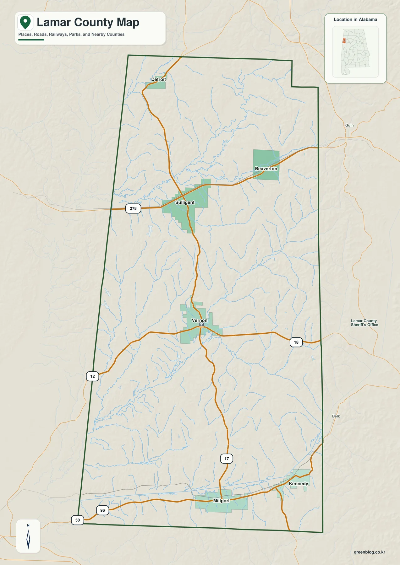
Vernon is the county seat and appears near the middle of the long north-south shape. Alabama 17 provides the clearest north-south reference through the central and southern parts of the county, while other state routes branch east and west from the Vernon area. If you are using the map to understand county government or simply to orient yourself, Vernon is the most practical starting point.
U.S. 278 is the most prominent east-west route in northern Lamar County. It runs through Sulligent and continues toward the Mississippi line, making the town a useful marker for the northern part of the county. On the map, the route is easy to spot because it crosses the county horizontally and intersects the road system that leads south toward Vernon.
The southern end looks different. Millport lies near the lower part of the county, Kennedy is farther east, and Alabama 17 provides an important connection back toward Vernon. Smaller routes and local roads spread through the rural areas between them. The map therefore shows why a simple north-south list of towns does not fully describe local travel: the road network branches around creek valleys and connects to different neighboring counties.
This map is most useful when you need a general geographic overview rather than a specialized layer. The bold county outline, labeled communities, highway shields, and blue water lines give enough context to understand where places sit in relation to one another. It also works as the base reference for the next three maps, which remove some details and emphasize cities, water, or elevation instead.
How the Six Mapped Places Are Distributed
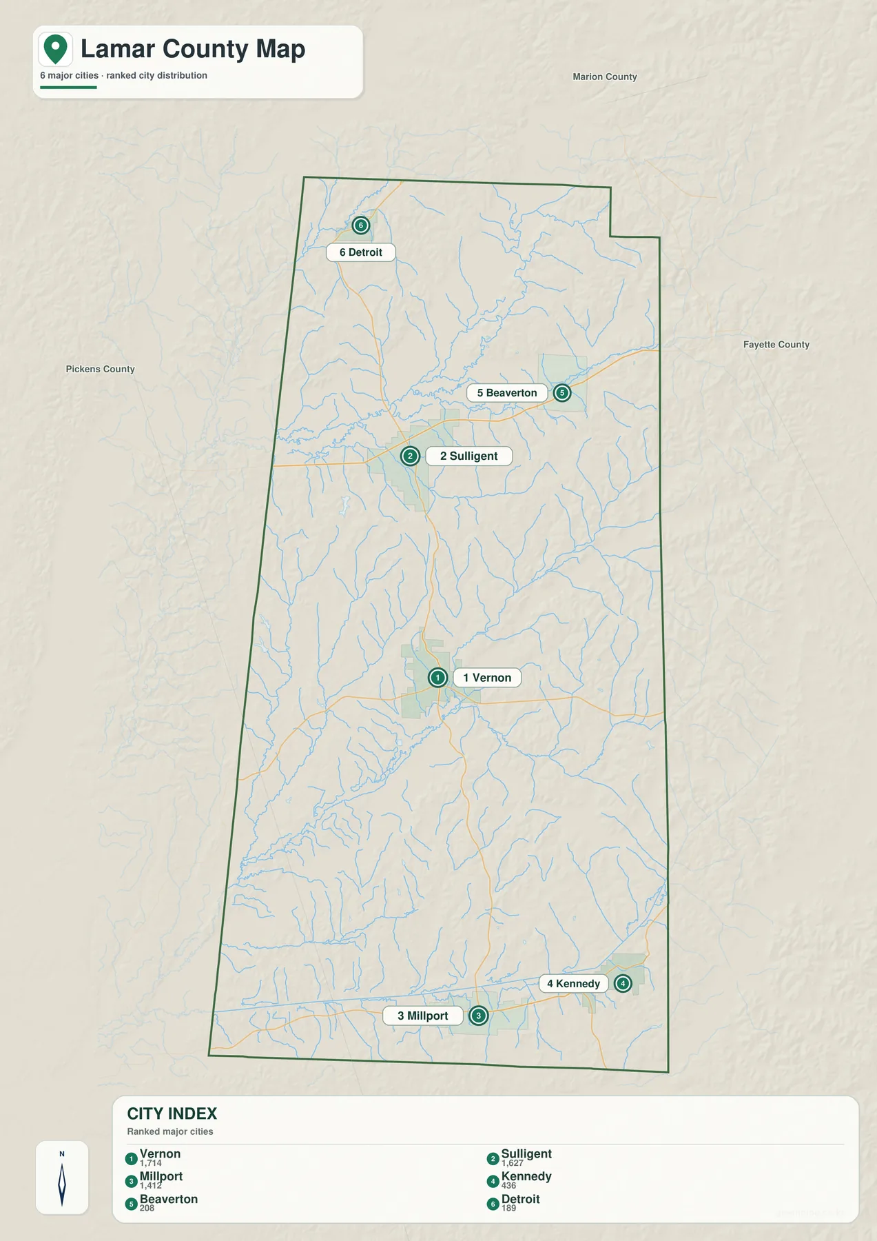
The city-focused version strips the geography down to six incorporated places and makes their spacing much easier to see. Vernon is marker 1, Sulligent 2, Millport 3, Kennedy 4, Beaverton 5, and Detroit 6. The numbered markers are especially helpful on a printed page because you can match each point to the city index without scanning through a dense set of labels.
The map’s city index lists Vernon at 1,714 residents, Sulligent at 1,627, and Millport at 1,412. Kennedy is shown at 436, Beaverton at 208, and Detroit at 189. These values make clear that even the larger places are small towns, which helps explain why the county’s geography is defined by the spaces and road connections between communities as much as by the settlements themselves.
The spacing also tells a story. Vernon is positioned alone in the central part of the county. Sulligent is well to the north, Beaverton lies east of it, and Detroit is farther north. Millport and Kennedy form a separate southern pair. This distribution divides Lamar County into several recognizable sections rather than one continuous built-up area.
When the city map is used to compare distances, remember that a straight line between markers is not the same as a driving route. Creeks, ridges, and the available road network can force travel to bend away from the direct line. For driving, use a road-navigation source; for a classroom worksheet, geographic orientation, or a quick visual comparison of settlement spacing, this map is the better choice.
Streams, Creeks, and Small Lakes Across Lamar County
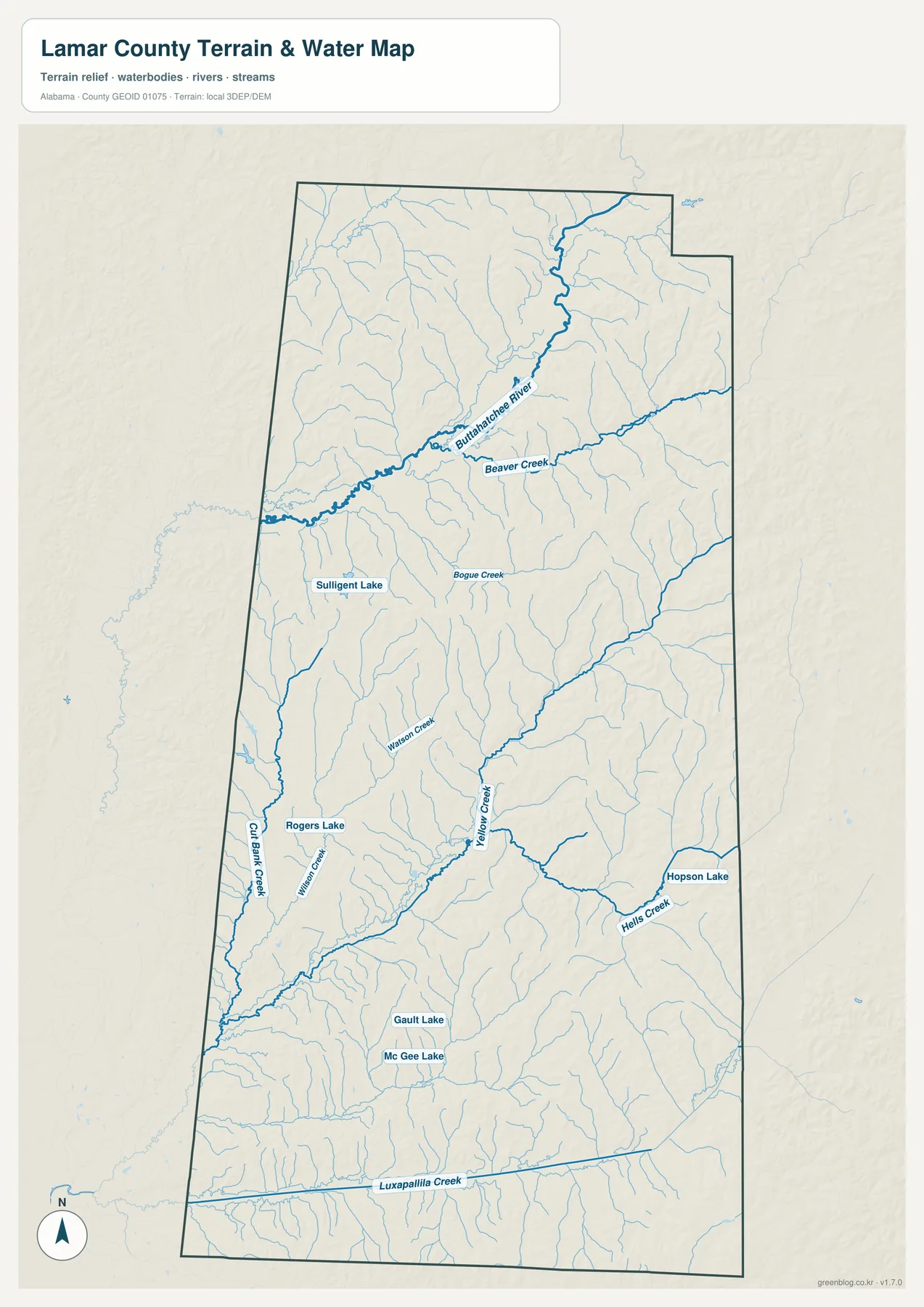
The water map reveals a much denser pattern than the general road map. In the northern half, the Buttahatchee River is one of the strongest blue lines and is joined by tributaries such as Beaver Creek. Bogue Creek appears farther south, while Watson Creek and Yellow Creek help define the central part of the county. Near the bottom, Luxapallila Creek crosses the southern area as part of the larger Tombigbee drainage system.
Several small named lakes are also visible, including Sulligent Lake, Rogers Lake, Gault Lake, Mc Gee Lake, and Hopson Lake. None dominates the county at the scale of a major reservoir, but they are useful landmarks when matching local places to nearby streams. If you are trying to identify an unfamiliar branch, finding one of the named lakes or a major creek first gives you a better reference point.
The Buttahatchee system continues westward beyond Alabama, and the Luxapallila system also belongs to the broader Tombigbee basin. This makes the Mississippi boundary more meaningful than a simple political line. Water does not stop at the county or state edge, so the map should be read as a local section of a larger drainage network.
This is a reference map for visible rivers, creeks, and water bodies. It is not a flood-hazard map, parcel map, legal water-boundary record, or navigation chart. If you need to determine flood risk for a property, confirm a legal boundary, or plan work in a stream channel, use the appropriate official source. For ordinary map reading, the main value here is seeing where water corridors lie in relation to roads and settlements.
Elevation Reveals the Ridges Between the Creek Valleys
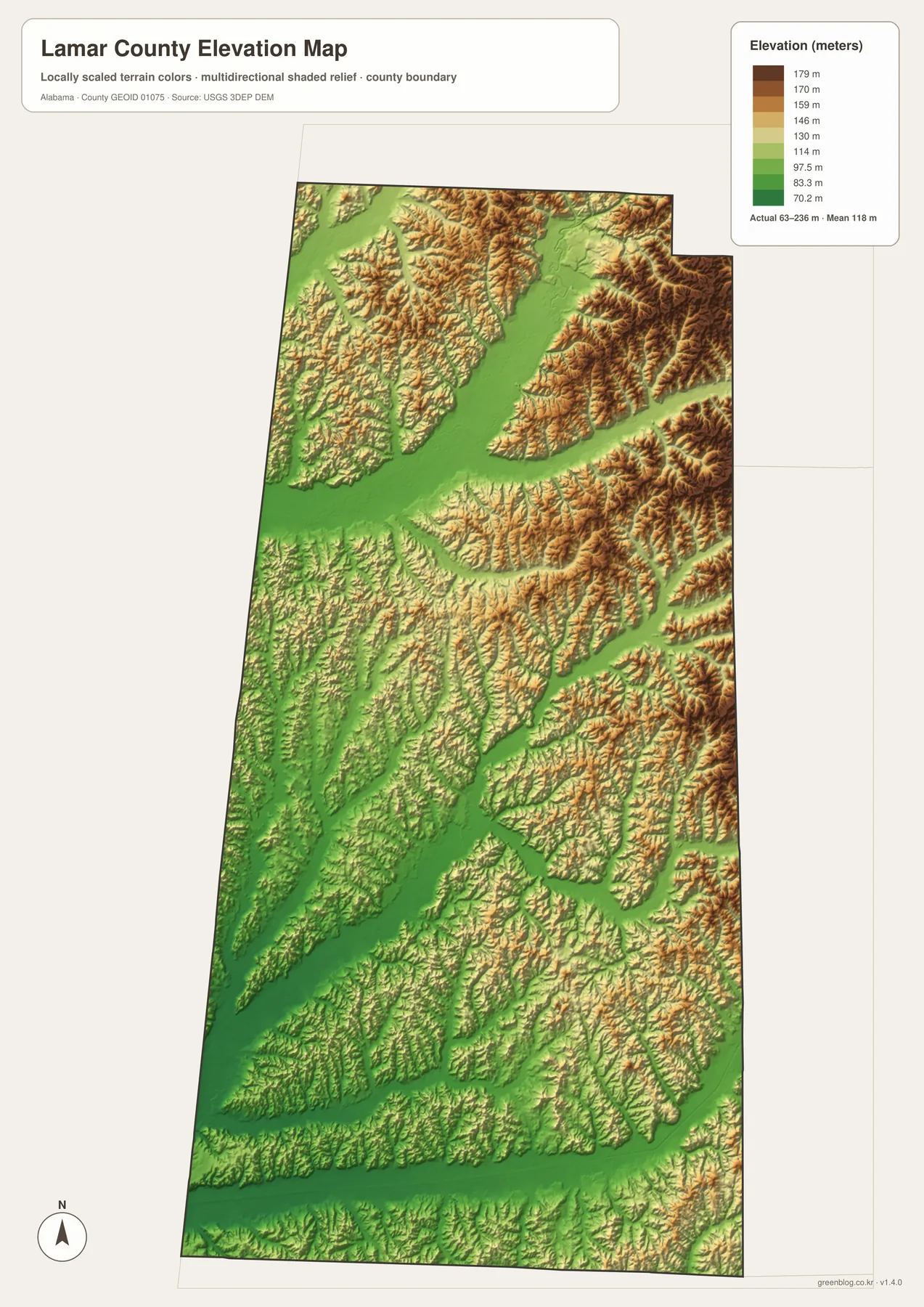
The elevation map changes the way the county looks. Instead of a flat background with roads and labels, it shows a closely spaced pattern of ridges and valleys. The map reports an actual elevation range of about 63 to 236 meters and a mean of 118 meters. Those values are modest compared with mountain regions, but the local relief is strong enough to shape roads, streams, and the appearance of the landscape.
Higher ridges are especially noticeable in the northern and eastern portions, where tan and brown bands break into many narrow spurs. Lower green corridors run between them and often line up with the stream network shown on the water map. The central and southern portions are not flat either; they contain repeated low valleys separated by smaller ridges.
Comparing the elevation and water maps is one of the most useful exercises in the set. Locate a major creek on the water map, then find the same general corridor on the elevation image. In many places the stream occupies a lower green strip bordered by higher ground. That relationship explains why local roads may curve, why crossings are concentrated at certain points, and why straight-line distance can be misleading.
The colors are scaled to make differences within Lamar County visible; they should not be treated as survey-grade measurements for a specific lot or construction site. The map is best for broad terrain comparison and for recognizing valleys, ridges, and drainage directions. Precise elevation work should be checked against the underlying USGS 3D Elevation Program or another authoritative survey source.
Roads, Rail, and Local History Explain Why the Towns Sit Where They Do
Lamar County’s administrative history is unusual. The supplied county history says the area was organized from parts of Marion and Fayette counties in 1867 as Jones County, later re-established as Sanford County, and renamed Lamar County in 1877. Vernon also had an earlier name, Swayne, before becoming Vernon in 1868. These changes help explain why the county seat’s role is tied to government history rather than to the later growth of railroad towns.
Sulligent developed with a different set of advantages. Its northern location and later railroad connection supported commercial growth, while U.S. 278 now gives it a direct east-west highway link toward Mississippi and the rest of northern Lamar County. Looking at the county map, the combination of the highway, rail history, and state-line direction makes Sulligent easy to distinguish from Vernon.
Millport’s history is closely connected to water-powered activity and then to rail. Creeks supported early milling and other local industry, and the arrival of the Georgia Pacific Railroad shifted activity closer to the tracks. Kennedy also grew after a railroad station was established, serving the surrounding agricultural area. Their positions near the southern end of the county are therefore more meaningful when rail and creek geography are considered together.
Beaverton and Detroit complete the northern and northeastern picture. Beaverton’s name is associated with Beaver Creek, and the community also developed along a rail line, while Detroit serves as a small northeastern reference point. Together, the six mapped places show several different reasons for settlement: courthouse government, highway access, rail service, farming, milling, and proximity to water.
Choosing the Right Map for Your Task
Use the general county map when you need the boundary, major roads, and labeled places in one view. Choose the city map when the main question is where Vernon, Sulligent, Millport, Kennedy, Beaverton, and Detroit sit relative to one another. The water map is better for tracing rivers and creeks, while the elevation file is the clearest way to compare low valleys with higher rolling ground.
- County map: best for overall orientation, main roads, labeled communities, and the county outline.
- City map: best for comparing the six incorporated places and using the numbered city index.
- Water map: best for the Buttahatchee River, Luxapallila Creek, tributaries, and small lakes.
- Elevation map: best for seeing how ridges and valleys relate to streams and roads.
You can also use the files together. For example, find Vernon on the county map, check nearby water lines on the water map, and then compare the same area on the elevation map. Repeating that process for Sulligent, Millport, or Kennedy turns the four separate images into a simple geographic study of roads, water, settlement, and terrain without forcing every detail onto one crowded page.
Frequently Asked Questions
Where should I start when reading the Lamar County maps?
Start with Vernon near the center of the county, then locate Sulligent and U.S. 278 to the north. Next, find Millport and Kennedy in the south and Beaverton and Detroit in the northeast. Once those six places are familiar, use the Mississippi state line and the major roads as fixed reference points when you switch to the water and elevation maps.
How should I compare the water and elevation maps?
Find a major water feature such as the Buttahatchee River or Luxapallila Creek on the water map and then look for the same corridor on the elevation map. Streams often follow the lower green valleys between higher ridges, so comparing the two files makes the terrain much easier to understand. The elevation layer is a regional reference, however, not a substitute for a survey, engineering measurement, or property-specific flood study.
Map File Information
Lamar County A3 Map Files
- Included Files: 4 high-resolution A3 JPG map files shown in this article
- File Type: JPG files in a ZIP archive
- Intended Use: Printing, education, presentations, and map-based projects
Related Maps
- Abbeville, Headland, and Lake Eufaula on the Henry County Alabama Map
- Autauga County Map
- Barbour County Alabama Map
Sources and Reference Data
- U.S. Census Bureau QuickFacts: Lamar County, Alabama
- Lamar County official history
- Alabama Department of Transportation Highway Functional Classification Maps
- USGS National Hydrography
- USGS 3D Elevation Program
Green Map creates custom-edited map images using open geographic data sources such as geoBoundaries, Natural Earth, OpenStreetMap, and government open data. These maps are edited visual materials, not raw data files, and are provided for education, documents, presentations, and graphic reference.